In January 2021, I drove up the Icefields Parkway to meet Matt Clay for an ultra-scenic suffer-fest on “Spreading Ridge.” As dawn broke, the gently-rising southeast ridge of Dolomite Peak (briefly) diverted my attention from the hot pink sky and spectacular alpenglow above the road. Whizzing by at highway speeds, I thought to myself: “That looks like it might make for a scenic snowshoe…” I casually mentioned this to Matt C. between breaths as we huffed and puffed our way up “Spreading Ridge.” Despite the fact that we were still in the midst of one exploratory snowshoe, we’d unknowingly started planning our next!
When we returned home, our initial guidebook and internet research turned up little. Examining photos from nearby peaks, however, confirmed that the ridge looked like a reasonable snowshoe target. Excited by our cleverness and originality, we wondered if we’d unearthed another untapped Rockies gem! In the final stages of our trip prep (the night before), additional internet sleuthing revealed that Dolomite Peak’s southeast ridge is actually a popular destination for backcountry skiers (who refer to it as “Dolomite Shoulder”). With the knowledge that we were neither as clever, nor as original, as we’d initially thought, Matt, his “wife” Sandra and I decided to head out nonetheless because, what the hell, it looked pretty! 🤣
.jpg)
After leaving Calgary under dark, COLD skies, we caught our first glimpse of Dolomite Peak and its “Shoulder” (right) as we descended towards Mosquito Creek on Highway 93. When we parked, we both remarked that it looked steeper than we remembered! We also noted that the predicted warming trend hadn’t hit the valley bottom yet as we geared up to deal with the frigid temperature (-24 C). 🥶
.jpg)
Only 24 hours earlier, we’d thought that this might be a rarely ascended, hidden gem. As we arrived at the peak’s base, however, we found ourselves among a caravan of skiers parked on the highway’s shoulder! On the upside, finding the best starting point (1.1 km north of Mosquito Creek) had proven to be a simple task…
.jpg)
Speaking of easy, travel proved remarkably straightforward as we left our cars and started up a veritable ski highway in the woods. After allowing me to take on the bulk of the trail-breaking last month, Matt C. graciously offered to return the favor today. Thanks Matt! 🤨
.jpg)
After travelling north for about 1.5 km, the terrain ahead leveled and Dolomite Shoulder’s steep lower slopes came into view to the west. Here, the highway of ski tracks split and we followed the westward branch (and 4 backcountry skiers) up through a mix of forest and glades.
.jpg)
Bright February sunshine punched through the forest as we ascended the steep lower slopes. This terrain was definitely steep enough to avalanche but we were comforted by stable conditions and by the fact that numerous skiers had already ascended in front of us.
.jpg)
Fluffy snow pillows mask the harsher terrain (cliffs) below. Mercifully, these were easily avoided!
.jpg)
After an initially steep ascent, the terrain levelled as we reached tree line and saw the Shoulder’s open, alpine slopes ahead. Concerned about windchill, we stopped here for a snack (only to later discover that it was windier in the trees than it was on the summit)!
.jpg)
Matt C. and Sandra start up the open slope above tree line. While we’d benefited greatly from the skiers’ up-track below, we left it behind here and opted to ascend more directly – one of the few benefits of snowshoes! Were it not for the plethora of tracks, we’d have been moderately concerned about wind slabs and their potential to avalanche on this slope. Thanks to its myriad ski tracks, however, we felt confident that any dangerous slabs had been chopped to pieces already. ✂️
.jpg)
Matt C. and Sandra pause for a breather and a photo.
.jpg)
Crowfoot Mountain comes into view as we continue ever upwards into the alpine.
.jpg)
As we ascended, the panorama behind us became more and more spectacular, prompting numerous photo breaks. Also, we needed to catch our breath! Click to see larger.
.jpg)
.jpg)
LEFT: A gloriously sunny day on the Icefields Parkway! After 2 weeks of extreme cold and COVID-related quarantine 😷, the mid-morning temperature finally started to rise and it felt amazing to be back outdoors!
RIGHT: Matt and Sandra don’t let the cold deter them. Despite temperatures below -30 C, they’d been out both previous days. Nevertheless, they seemed happier as it became clear that we wouldn’t lose any fingertips today!
.jpg)
.jpg)
LEFT: Following the skiers’ skin-track up a slope of some concern. It was far from extreme but it could “go” given the right conditions. Despite thinning air, we didn’t linger here.
RIGHT: Upon gaining a rocky bench, we finally bore witness to Dolomite Shoulder’s steep “summit” block. About halfway up, the slope became too steep and rocky to ski and the skiers in front of us left their gear behind at, what looked like, a mix between a base camp and a yard sale.
.jpg)
Someone else’s skis add a splash of color at the “yard sale.”
.jpg)
Matt C. and Sandra start up the final, steep slope, obliterating the skiers’ boot-pack track with their snowshoes. For my part, I opted to switch to micro-spikes here and added my snowshoes to the “yard sale.” Secretly, I hoped that one of the skiers would steal my ‘shoes and leave their skis for me to enjoy on the trip down!
.jpg)
The last few steps to the summit proved mildly exposed but were made much easier thanks to the broken trail. A slip here wouldn’t be fatal but it would certainly send your heart into your throat! For my part, I just made sure that I didn’t slip. Photo courtesy Matt Clay.
.jpg)
.jpg)
LEFT: As we took the final steps towards Dolomite Shoulder’s summit, Dolomite Peak’s vertiginous towers finally came into view.
RIGHT: Knowing that Sandra doesn’t care for exposure, I was pleasantly surprised when she made quick work of the final, somewhat airy, traverse. She was obviously happy to be on the peak’s small summit but I did notice that she preferred to hunker down and keep close to the ground the whole time that we were up there! 🤣
.jpg)
And "Boom" goes the "Dolomite"! A pretty decent summit view for a “Shoulder”! 😍 Click to see larger.
.jpg)
Looking west beyond Dolomite Peak’s sheer ramparts towards the Crowfoot Glacier and Bow Lake below. Above, a host of Wapta summits (including Crowfoot Mountain, Mount Rhonda, Mount Habel, Portal Peak and Mount Thompson) are also visible.
.jpg)
Looks like I’m 2/2 when it comes to spectacular snowshoe summits in 2021! Spreading Ridge might be hard to top but Dolomite Shoulder certainly gives it a run for its money! Better still, we reached the summit in only 3 hours thanks to the well-established skin-track; a far cry from the suffer-fest Matt C. and I “enjoyed” on Spreading last month!
.jpg)
Nearby Dolomite Peak’s towers appear to be impenetrable. Fortunately, they’re not!
.jpg)
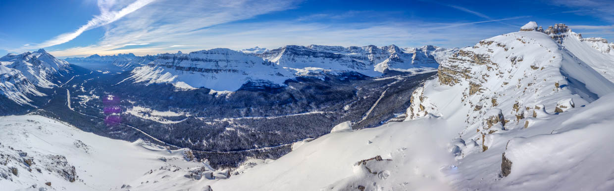
The beautiful alpine valley between Dolomite Peak and OXO Peak filled the panorama to the northeast. This valley is part of the popular “Dolomite Circuit” ski tour. Click to see larger.
.jpg)
OXO Peak rises impressively to the east of Dolomite Peak.
.jpg)
OXO Peak (left) and its outlier Puzzle Peak (right). 11,000er Mount Willingdon pierces the blue sky at center while the Quartzite Peak/Ramp Peak/Mosquito Mountain triad rise up to the right.
.jpg)
.jpg)
LEFT: Ski tracks litter Puzzle Peak’s steep slopes. It seems that this is a popular ski destination as well (despite the fact that a huge chunk of the peak fell off only a couple of years ago – note the divot below the summit…).
RIGHT: Four tiny skiers start the long trip up Puzzle Peak. From Dolomite Shoulder, we witnessed skiers ascending and descending nearby Puzzle. On the way down, they needed less than a minute to cover 400 – 500 vertical meters. The way up, however, proved less exciting to watch from afar!
.jpg)
Looking east towards Ramp Peak (left), Mosquito Mountain (center) and the Three Brothers (right).
.jpg)
To the south, the panorama stretched from Banff’s remote east ranges to the high peaks of the Continental Divide. Click to see larger.
.jpg)
A pair of peaks named after flies (Mosquito and Noseeum) bookend North Molar Pass. No need for bug spray today, however!
.jpg)
Cataract Peak (center right) towers to the east beyond North Molar Pass.
.jpg)
Reveling in the scenery high above the Icefields Parkway with Noseeum Mountain, Mount Andromache and Mount Hector.
.jpg)
.jpg)
LEFT: A closer look at Mount Andromache, Mount Hector and Little Hector.
RIGHT: Looking south down the Icefields Parkway towards the Bow Valley.
.jpg)
Mount Temple towers over the Bow Valley. Other prominent peaks include: Storm Mountain, Mount Ball, Stanley Peak, Bident Mountain, Quadra Mountain, Haddo Peak and Mount Aberdeen.
.jpg)
The famous Lake Louise group including (from left to right): Deltaform Mountain, Mount Lefroy, Mount Hungabee and Mount Victoria.
.jpg)
Mount Daly (right) rears skyward beyond the Grand Daddy Couloir (a bold ski line on nearby Bow Peak).
.jpg)
Looking west towards the Wapta Icefield. Click to see larger.
.jpg)
Bow Peak.
.jpg)
A telephoto towards more distant Mount Balfour.
.jpg)
Bowcrow Peak (left) and Crowfoot Mountain (center).
.jpg)
A closer look at Crowfoot Mountain: the highlight of my summer scrambling season last year!
.jpg)
After far too many summit photos and an hour-long rest on the, shockingly warm, windless summit, we began our descent, cautiously crossing the more exposed bit just below the summit.
.jpg)
Sandra clings to the snow slope and I snap a few more photos while waiting for my turn. Mind the drop on the left and the cornice on the right! 😬 Photo courtesy Matt Clay.
.jpg)
.jpg)
LEFT: Matt and Sandra carefully descend the summit block’s steepest terrain above the “yard sale.”
RIGHT: Breathing easier on more mellow terrain!
.jpg)
The summit proved a tad small for a group photo so we paused for a 2 meter-ish distant one when the terrain mellowed below.
.jpg)
While a descent on skis would have been a blast, our slower snowshoes gave us plenty of chances to savor the spectacular views.
.jpg)
Plunge-stepping down alpine slopes proved to be reasonably fast and fun anyways (provided that you kept your balance unlike poor Sandra…) 🙃.
.jpg)
Puzzle Peak, Quartzite Peak, Ramp Peak and Mosquito Mountain made for a pleasant, final alpine view as we returned to tree line.
.jpg)
.jpg)
LEFT: Sandra enjoys quick travel along the ski highway below tree line.
RIGHT: Only an hour and half after leaving the summit, we found ourselves back at our cars. With the business of peak-bagging behind us for another day, all that remained was to enjoy a calorie-dense celebratory beverage!
Cheers to spectacular snowshoe summits! 🍻 Whether they’re obscure and unexplored or popular and tracked-out, who cares when they’re this pretty!
.jpg)
.jpg)
.jpg)
.jpg)
.jpg)