Storm Mountain
Elevation: 3161 m
Elevation Gain: 1500 m
George Dawson had a high affinity for the name “Storm Mountain” (and apparently poor luck with weather). Dawson is alleged to have named Storm Mountain after observing inclement clouds on its summit during his time in the area in 1884. The same man is also responsible for naming the Storm Mountain located in Kananaskis Country for the same reason during the same year. Regardless of Dawson’s lack of creativity, both Storm Mountains are stunning peaks – it seems unfortunate that Dawson’s view of them may have been obstructed by poor weather! This particular Storm Mountain was first ascended in 1889 by W.S. Drewry, A. St. Cyr and Tom Wilson.
My Ascents:
August 14 2011
Trailhead: Storm Mountain Parking (Roadside)
Although Storm Mountain is stunning from both Highway #1 and Highway #93 South, I was never particularly tempted to make my way up it based on the route description provided by Kane. What can I say? Hours of log hopping and bushwhacking in prime grizzly territory followed by a steep treadmill of scree didn’t sound all that appealing! Fortunately for me, Roland was more keen on this objective and suggested it as a last minute trip. I wasn’t certain how enthusiastic I was to take on a big objective (1500 vertical meters) like this 2 days before Brianne and I were supposed to back-pack the long 29 km into Mount Assiniboine and 1 day after a quick outing up Paget Peak but, in the end, the little peak-bagging devil on my left shoulder won out over the little voice of reason on my right shoulder (as he often does). Luckily, in researching the trip, Roland had come across Vern Dewit’s trip report and, thanks to the “faint trail” Vern describes, the log-hopping approach was made somewhat more tolerable!
.jpg)
"Rugged going" (as Kane puts it) for the first distance across the old Vermillion burn. Basically good times hopping logs for the first hour. The “faint trail” that Vern Dewit describes is just that – faint. I’m not certain that the trail really makes the log-hopping any easier but at least it provides a sense of direction and purpose on an ascent that would, otherwise, be tedious.
.jpg)
No more vegetation from here on in. Steep walls on all sides once you enter the amphitheater.
.jpg)
The steep ascent route, complete with "laborious scree" (once again, Kane doesn’t really sell this one all that hard). Truth be told, the scree wasn’t the treadmill variety that I had feared on the way up. In fact, it was actually quite solid. While this made the ascent more pleasant than anticipated, there was, nevertheless, a downside – the knee-jarring descent.
.jpg)
A tarn is revealed in a cirque to the north as elevation is tediously gained.
.jpg)
Roland near the top of the scree ledge where several different gullies provide the most interesting scrambling of the day.
.jpg)
After about 800 vertical meters of scree, the angle did finally relent granting a pleasant walk to the top along the mildly angled broad summit plateau.
.jpg)
A spectacular view of Mount Ball's north face from the summit of Storm Mountain!
.jpg)
The awesome cornices atop Storm Mountain can often be seen from the Trans-Canada highway below (beyond Copper Mountain below).
.jpg)
Roland enjoying the view, including a distant Mount Assiniboine.
.jpg)
Massive Mount Assiniboine dwarfing everything in its vicinty.
.jpg)
My 31st summit of the year is one of the most scenic yet! Copper Mountain, Pilot Mountain and Mount Brett over the Bow Valley to the east.
.jpg)
Mount Rundle rising up from behind the difficult summit block of Pilot Mountain.
.jpg)
Cascade Mountain: the other classic Banff peak.
.jpg)
Looking east to the front ranges. Mount Aylmer is the highest shady peak on the left.
.jpg)
Mount Sparrowhawk, Mount Bogart and Old Goat Mountain pierce the horizon in Kananaskis Country.
.jpg)
A very distant 11,000er: Mount Joffre shows its glaciated face beyond The Towers.
.jpg)
The usual summit hero pose.
.jpg)
Beautiful glacier panorama along the continental divide. Mount Ball on the left and Stanley Peak on the right. Click to see larger.
.jpg)
The Stanley Glacier clinging to the steep north face of Stanley Peak.
.jpg)
Thanks to excellent visibility, we could see as far as the Howser Spire - the higest point in BC's Bugaboo Range.
.jpg)
Gorgeous Mount Ball.
.jpg)
Looking south towards the Egypt Lakes area.
.jpg)
The Goodsir Towers (left) and Mount Vaux (center) to the west beyond reddish Mount Whymper.
.jpg)
11,000ers Mount Deltaform, Mount Hungabee and, of course, Mount Temple provide highlights to the northwest.
.jpg)
Mount Lefroy (left) and Temple (right).
.jpg)
The Icefields Parkway to the north: Hector Lake, Bow Peak, the Dolomites and Mount Hector.
.jpg)
The Castle Mountain massif across the Bow Valley.
.jpg)
Close-up of Castle Mountain and the Eisenhower Tower.
.jpg)
From the Icefields Parkway to Castle Mountain to Banff to Kananaskis to Kootenay National Park to the Bugaboos to the Goodsirs to Lake Louise, Storm Mountain is well situated for getting a full view of the Canadian Rockies/Purcells! Click to see larger.
.jpg)
The other 180 degrees. Click to see larger.
.jpg)
We coordinated our poses ahead of time. Actually, I think we were both just cold.
.jpg)
Time to head down! Mind the cornice...
.jpg)
Typical knee-destroying hard scree on descent. Can you spot the tiny chemistry professor?
.jpg)
Alleviating the toil on the bothersome scree by glissading.
.jpg)
The house sized boulder that Kane describes in the amphitheater. Not sure how we missed it on ascent! Professor shown for scale.
.jpg)
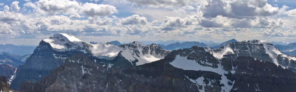
The classic highway view of Storm Mountain from near Castle Junction. This peak’s not half as bad as Kane’s route description makes it sound! It’s also very well-situated to see peaks all over the Rockies (and Purcells)! On a clear day, you might even find yourself enjoying this peak; I certainly did!
.jpg)
.jpg)
.jpg)