August 16th was supposed to be my grand summer adventure featuring an overnight atop a big peak. Unfortunately my plans unraveled at the last minute when my climbing partner had to pull out due to a family emergency. As I attempted to salvage my trip, I emailed and phoned every hiker, scrambler and climber that I knew hoping that someone would be available for a 2 day trip midweek on less than 24 hours’ notice. Predictably my “Hail Mary” fell incomplete.
I was about to cancel my planned days off of work when Matt Clay mentioned that he’d be up for a scramble but not one as grand as my original objective. Among the several trips he suggested, Ramp Peak and Quartzite Peak stuck out. Having set my heart on something big and more technically demanding, these 2 scree slogs didn’t really light my fire but I knew that they were scenically located and had been hoping to catch up with Matt for some time. Besides, I’d yet to climb a peak starting with the letter “Q”, so Quartzite would at least grant me that chance! With forecast fine weather, it seemed a shame to cancel approved time off, so Matt, his wife Sandra and I made plans to leave Calgary at 5:30 am for a "Plan B" two’fer.
.jpg)
The 2.5-hour drive to the Mosquito Creek trailhead along the Icefields Parkway flew by as Matt and I caught up. It was hard to believe but it had been 8 months since we’d gotten out together! Once we arrived, Sandra and I poked around for an outhouse before settling on using the woods. With the morning’s chit chat and “business” taken care of, we carefully crossed the highway and started up the Mosquito Creek trail at an energetic pace.
.jpg)
The first couple of kilometers along the trail proved rather wooded and dull but they did allow for fast-travel. We also noted that the sky looked decidedly more overcast than various weather models had predicted but Matt assured Sandra and I that these clouds would burn off as the day progressed. By the time that we reached the day’s first scenic vista, we were all ready to stop, take off a layer and take in the view of our, still-distant, objectives rising up beyond wildflower-lined Mosquito Creek. From left to right: Quartzite Peak, Ramp Peak and Mosquito Mountain.
.jpg)
Dew drops on fireweed attest to the morning’s humidity and cool air.
.jpg)
After travelling along the Mosquito Creek trail for about 4 km, we found the unmarked turn-off for the much-fainter Quartzite Col trail just before the main trail veers sharply south at a bridged crossing. We then followed the faint trail up-valley alongside a noisy but unnamed creek.
.jpg)
Travel on the faint trail proved pleasant and after about 2 km, Matt declared that it was time to cross the creek. Having done zero research for this trip (it was Matt’s idea after all), I happily obliged and gracefully waltzed across a conveniently placed log.
.jpg)
Rather than risk a frigid fall from the log, Matt and Sandra opted to ford the knee-deep creek just downstream. I suppose they’re just not as graceful as I!
.jpg)
Once we’d crossed the stream, Matt suggested that we bushwhack directly towards Ramp Peak instead of poking around for a trail. Hoping that this would lead to some high-quality suffering, we were understandably disappointed to discover that the forest was thin and that off-trail travel directly uphill proved to be little more than flower-whacking.
.jpg)
After some steep but easy off-trail hiking, we reached a spacious alpine plateau which offered fine views towards the day’s objectives.
.jpg)
Matt and Sandra prove that the alpine meadows below Ramp Peak aren’t as flat as they seem. While I managed to minimize unnecessary ups and downs by contouring strategically, Matt proved quite adept at hiking up (and then back down) pointless little bumps!
.jpg)
After an unusually wet summer, I’d anticipated a wildflower bonanza in the meadows below Ramp Peak. Sadly, these paint brushes were among the very few flowers that we actually found.
.jpg)
Matt and Sandra hike through an unusually desolate alpine meadow which leads to Ramp Peak’s even more desolate scree slopes. Between the surprising lack of wildflowers and unexpectedly overcast sky, I was starting to feel a little bummed out by Ramp Peak.
.jpg)
Of course, things can always get worse (as we soon discovered). The final 500 m of our ascent would take us up and over some genuinely steep and awful scree. As we groveled up, we quickly came to understand why many opt to ascend Ramp on skis in the winter!
.jpg)
The speedy Dr. Clay provides a sense of scale along Ramp Peak’s impressive and overhanging summit ridge. Mercifully, this ridge marked the beginning of the end (for our first peak of the "Plan B" two’fer anyways)!
.jpg)
A long hour after we set out from the alpine meadows 450 m below, we were relieved to arrive at the summit and be done with Ramp Peak’s miserable scree. Despite Matt’s earlier assurances that the sky would clear, it seemed that the weather had other plans and a viciously cold wind blew in wildfire smoke to further mute what should have been sublime summit views. All told, Ramp Peak proved to be a bit of a sh*t sandwich. Click to see larger cloudy, smoky, cold views.
.jpg)
Nearby OXO Peak provided a bit of a scenic highlight to the northwest. As you can see, the bigger peaks beyond OXO were largely lost in either cloud or smoke.
.jpg)
Our next objective (Quartzite Peak) rises sharply above a scenic but unnamed lake. As you can see, some pretty significant cliff bands prevent a direct traverse between the two. Beyond Quartzite, Watermelon Peak and Bobac Mountain (center left) are both visible despite the haze.
.jpg)
Along with the lake, my bright yellow jacket and I provide a splash of color in front of Clearwater Mountain on an otherwise gray day.
.jpg)
Peering over Ramp Peak’s sheer northeast face towards a remnant pocket glacier far below.
.jpg)
A verdant valley fills the panorama to the east. The nearby highpoint of this valley is Pipestone Pass and marks the headwaters of the Siffleur River. Click to see larger.
.jpg)
To the southeast, neighboring Mosquito Mountain rises up higher than either Ramp Peak or Quartzite Peak. To its left, the Three Brothers (left), Cataract Peak (center left) and Ptarmigan Peak/Mount Richardson (center) are all faintly visible.
.jpg)
The panorama to the south overlooked our approach valley which was bookended by Noseeum Peak (left) and OXO peak (right). This scene should have been filled with the spectacular peaks of the Waputik Icefield but smoke and low cloud hid all of these slightly more distant summits. Click to see larger.
.jpg)
A closer look at the glaciated northeast faces of Mount Hector (in the clouds of course), Little Hector, Mount Andromache and Noseeum Peak to the south.
.jpg)
Mosquito Creek winds its way down our approach valley towards Bow Peak. Beyond, the spectacular glaciers clinging to Mount Balfour’s east face are faintly visible but the peak itself is not.
.jpg)
Matt Clay gets right into our first Instagram photo shoot as I adopt the classic “mermaid pose” on an exposed outcrop high above the Siffleur River Valley. This scene became necessary after a sarcastic exchange back and forth between Matt and I on Facebook earlier this summer. Matt posted a photo showing his usual hiking partners (who it must be noted make much better posers than he and I) going to absurd lengths to capture the perfect Instagram photo. After commenting on his photo, it was decided that he and I would have to recreate it the next time that we got out. How did we do?
.jpg)
With our photo shoot complete, there was little reason to stay atop Ramp Peak’s frigid, smoky summit so we made haste back down. Mercifully, Ramp’s scree proved more pleasant to descend than it had been to grovel up! After descending about halfway, we veered off our ascent line in order to take a more direct line down towards our next "Plan B" objective Quartzite Peak.
.jpg)
A lovely patch of vibrant green moss provided a soft place to sit and enjoy a respite from the wind between Ramp and Quartzite Peaks. With Quartzite’s orange scree ascent slopes (right) looking almost as pleasant as Ramp’s had been, we were in no hurry to move on and enjoyed a long break and some delightful homemade baking here (thanks to Matt and Sandra for sharing)!
.jpg)
Munching on delicious goodies and looking back up towards Ramp Peak, one could be excused for thinking that it was actually a nice day! Unfortunately, the skies were not clearing but, at least, there was a large “sucker hole” atop both of our objectives.
.jpg)
After an extensive break, we realized that Quartzite Peak wouldn’t climb itself and, so, set forth up its uninspiring scree ascent slope.
.jpg)
As we ground our way up Quartzite Peak and stared at our feet, this was our main view: blocky orange scree with interesting slots. Fortunately, this scree proved much easier to ascend than the gray garbage we’d found on Ramp Peak. Matt even described it as “pleasant” (though I’m not sure I’d go that far).
.jpg)
Despite enjoying Quartzite’s scree so much, Matt, apparently, felt the need to race up it. Sandra and I, on the other hand, opted for a more casual pace which allowed us to truly “enjoy” the reddish rubble.
.jpg)
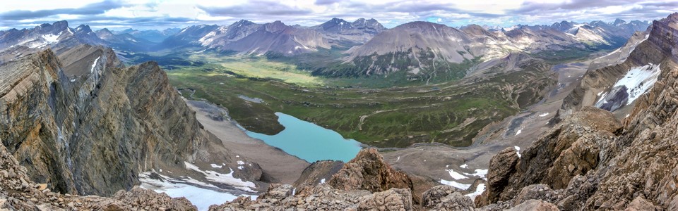
Upon reaching Quartzite’s summit ridge, the view of the green Siffleur River Valley and bright blue (somehow unnamed) lake below once again stole the show. Across the valley, 11,000er Mount Willingdon rises up above Clearwater Pass.
.jpg)
Sandra and I continue to grind our way up the summit ridge while Ramp Peak (left) and Mosquito Mountain (center left) rise up behind us. Photo courtesy Matt Clay.
.jpg)
Atop Quartzite Peak, we found a soaking wet register which contained the peak’s (still-dry) first ascent record. Based on this record, we should perhaps be calling this summit “Porcupine Mountain” and not “Quartzite Peak.” In this day and age of online trip reports, however, I suspect that the more widely used online name will end up trumping the small piece of paper placed in a film canister some 48 years ago.
.jpg)
A smoky southern summit panorama from the summit of Quartzite Peak. This year’s unusually wet summer had provided an almost complete respite from the thick smoke that covered western Canada in 2017 and 2018 so we were completely shocked to find smoky skies on this day! On a personal note, I was especially disappointed by the smoke since it seemed to manifest out of nowhere on the only day in August that I was able to get out for a scramble! Click to see larger.
.jpg)
Hazy views southeast towards aptly named Molar Mountain (center), more distant Ptarmigan/Pika Peak and Mount Richardson (right).
.jpg)
A dizzying notch and chasm along Quartzite’s summit ridge immediately north of its apex. As I looked down the notch into the valley far below, it became apparent that a great mass of rock had slid clean off of Quartzite Peak, depositing an enormous pile of rubble in the valley below. Indeed, standing here one got the sense that the whole peak might be on the verge of collapse!
.jpg)
To the east, the green Siffleur River Valley, Clearwater Pass (center), Pipestone Pass (right) and a series of pocket glaciers immediately below were the highlight of our summit stay. Of course, it helped that the cloud and smoke seemed to be less prevalent in this direction! Click to see larger.
.jpg)
A closer look at Watermelon Peak (center) and Bobac Mountain (right).
.jpg)
Posing once more (albeit less ridiculously than on Ramp Peak earlier).
.jpg)
The three peaks of the Willingdon massif (Willingon, Crown and Tower) rise up beyond Clearwater Pass to the northeast.
.jpg)
Nearby Devon Mountain looks like a lovely scramble if you’re willing to brave the long hike to its base.
.jpg)
A dirty pocket glacier clings to Ramp Peak’s sheer northeast face above Pipestone Pass.
.jpg)
The Three Brothers (left) and massive Cataract Peak (right) highlight the view beyond Pipestone Pass to the east.
.jpg)
Posing for a colorful but cold group summit photo before retreating to the valley’s relative warmth.
.jpg)
Rather than returning the way that we came, we opted to follow pleasant scree down and into the valley to the west of the one that we’d ascended.
.jpg)
Matt and Sandra take a moment to pose with Noseeum Mountain during our descent. Having notched her 250th unique summit atop Quartzite, Sandra had good reason to smile! Bravo!
.jpg)
Passing through a massive debris field as we continue down. What once had been solid mountain here has now been reduced to house- and apartment-sized boulders heaped violently atop one another! In addition to adding some variety, the chance to investigate this impressive slide more closely provided ample motivation for our alternate descent.
.jpg)
As we descended the soft scree into the devastated valley, we discovered hoof prints which preceded us. After a careful scan of the surrounding mountainscape, we also managed to find their maker (who had decided to saunter up an impressive cliff when he heard us coming)!
.jpg)
GOAT!!!
.jpg)
After making the goat’s acquaintance, we continued down past the bouldery devastation and into a lush green valley below. Looking back up at Quartzite Peak, the full extent of the slide became awe-inspiringly obvious. Indeed, it seems that a hundred-vertical-meter-thick layer of reddish rock completely cleaved off of the underlying gray rock and slid violently down the west end of this mountain! Moreover, the lack of trees or vegetation atop the boulders below suggests that this occurrence was relatively recent.
.jpg)
After taking some time to grasp the magnitude of the Quartzite slide, we followed a babbling waterfall down towards more pastoral terrain below.
.jpg)
The noisy creek charted a mossy path through and around the boulders that, until recently, had been firm mountain.
.jpg)
Some of the valley’s smaller boulders provided an excuse for some hands-on scrambling (that’s right – this was one of the smaller boulders)!
.jpg)
As the rubble flow gave way to alpine meadows, we were astonished to discover a sea of colorful wildflowers! We’d been hoping to find this vibrant bounty below Ramp Peak and were quite disappointed when the desolate meadows there failed to provide it. Thank God we opted for an alternate (and unknown) descent! Between the rock slide, the waterfalls, the flowers and the GOAT, this little valley was the true highlight of the day. A day that was best-described as a cloudy, cold, smokey sh*t sandwich only hours earlier was now proving to be an absolute f*cking gem!
.jpg)
Arnica (unless Matt Clay tells me otherwise).
.jpg)
Aster (unless Matt Clay tells me otherwise).
.jpg)
Slide survivors: paint brushes and pasque flowers dance in the gentle alpine breeze just beyond the reach of Quartzite’s cataclysmic slide.
.jpg)
While we could have spent hours exploring, photographing and frolicking in the pristine alpine meadow, the hour was growing late and we still had a long hike back across unknown terrain. While some of the descent was steep, it was never more than off-trail hiking with good flower-whacking to be had.
.jpg)
After a steep but easy descent into the valley, we found the creek which we crossed earlier and followed it back towards the spot where we originally crossed. Travel alongside the noisy creek was quick and easy and, in relatively short order, we found ourselves back on the veritable highway that is the Mosquito Creek trail.
.jpg)
Following fireweed-lined Mosquito Creek back out towards Highway 93N. As we plodded on down the mostly dull trail, visions of hamburgers began to dance in our heads…
.jpg)
After a fairly lengthy day that included two "Plan B" peaks, 1540 m elevation gain and 21 km of hiking, we decided to treat ourselves to a burger at the Lake Louise Hostel. When we arrived, we were, however, devastated to discover that the hostel was closed for a staff event. After discovering long lineups at the nearby Post Hotel Pub and Lake Louise Inns, we were relieved to find surprisingly delicious “Plan D” burgers the Husky gas station’s “Mountain Restaurant.” They even had kids-meals and coloring for Matt! Way to stay inside the lines Doc! 😉
As with most mountain days, this outing provided its share of highs and lows (both literal and metaphorical). I could have done without smoke, cloud and cold but if we hadn’t endured them, we never would have seen what happens when a mountain collapses, met a goat or frolicked amidst a colorful carpet of wildflowers in pristine pastoral surroundings. I suppose that’s why it’s best to always have a “Plan B” on-hand in the mountains (and better still when it’s a two’fer)!
.jpg)
.jpg)
.jpg)
.jpg)
.jpg)