Elevation: 2160 m
Elevation Gain: 125 m
The Windy Peak Hills are a series of 4 front range high points which stretch to the north of Windy Peak. Like their namesake peak, the aptly titled hills take their name from the frequent high winds that batter this part of southern Alberta.
My Ascents:
July 4 2020
Trailhead: "The Hump" (Highway 532 Highpoint)
To date, our summer can be summed up in 3 words: camping, camping and camping! 2020 has been a disappointment in many ways but, at the very least, we’ve been able to make the most of the summer season! After a couple of family camping trips, we decided to slightly expand our “bubble” and invited our best-friends Chris and Jenn for an “extended family” weekend.
Since camping and hiking are synonymous in the Hobbs household, we invited Chris and Jenn to join us for a sunny Saturday outing. Having attempted Hailstone Butte a year earlier, we were familiar with Highway 532’s steep route up “the Hump.” “The Hump” is a high pass that grants easy access to South Kananaskis’ alpine environs. In essence, it’s a great place to start a hike since most of the elevation is gained by car! After last year’s debacle on Hailstone Butte, we were hesitant to return to “the Hump” but, for better or worse, we threw caution to the wind and set off to explore the hills which lead south from there towards Windy Peak.
A full parking lot suggests that we weren’t the only ones looking to take advantage of “the Hump’s” high elevation. From the parking area, we followed a faint trail directly up the grassy hill on the left. On descent, we tried to find a more sheltered route down along an old road which is accessed from the east side of this pond. Both routes work equally well and (spoiler alert) neither is actually sheltered.
LEFT: Our colorful little hikers make their way up towards the first Windy Peak Hill. As Penny’s sideways-flying hair suggests, the hill lived up to its name!
RIGHT: Mera wanted to carry her “Friend Rabbit” up the hill (spoiler alter: Dad ended up carrying “Friend Rabbit” 99% of the way).
After ascending sparse trail and open meadow, we met up with the main ridge-top trail (which continues down to the old road that we used on descent). Ahead, the high point of the first Windy Peak Hill can be seen in the center of the photo.
Wind-twisted roots and lichen-livened rocks add to the alpine scenery as we meander ever upwards amidst hurricane-force winds.
Jenn enjoys a good hair day while Chris holds our eldest’s hand to keep her from flying off to Saskatchewan.
Our “summit” for the day – the high point of the first Windy Peak Hill. On a calm day, this place would be serene. With sustained winds in the 70 km/h range, however, this was not that day!
While Chris held Mera’s hand to keep her grounded, we opted to anchor Penny directly to my back. As you can see, she did not object.
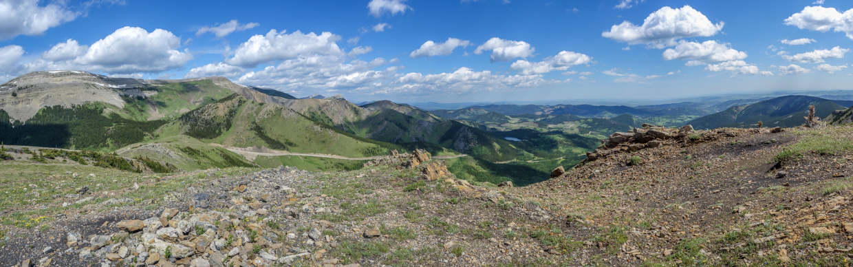
Windy Peak Hill offers a wonderful panorama provided that a gust doesn’t knock you off your feet while attempting to enjoy it! Click to see larger.
Highway 532 runs along the base of Hailstone Butte to the north.
A closer look at Hailstone Butte’s fire lookout-adorned summit. The rock bands to the lookout’s left proved to be our undoing during a multigenerational family attempt in 2019.
Chris and Mera look out over Bear Pond and the verdant foothills that surround it.
Looking south towards Saddle Mountain (left), Windy Peak (center) and Mount Livingstone (center right). The traverse to Windy Peak looked quite pleasant but the vexing wind had already frayed our nerves only 1-km into the hike so we opted to enjoy the hilltop view quickly before retreating.
Looking southwest towards Monola Peak (center left), Isola Peak (center) and Monad Peak (center right).
Beating a hasty retreat in search of some form of shelter from the relentless gale.
A couple of us were still having fun at least!
Pleasant views as we continued downwards. Mercifully, the cluster of trees in the center of the photo provided the day’s only respite from the wind, giving us a chance to eat lunch!
A Krummholz island of serenity in the hurricane’s eye.
Scenic stunted growth suggests that the day’s meteorological conditions were not an isolated event…
In the hope of finding shelter in a slight lee, we followed the old road all the way back to Highway 532 on descent. Despite appearances, however, the road provided no respite from the wind. In fact, we ran into some of the day’s fiercest blasts while hiking down it!
Brianne tackles the day’s crux – balancing across a Texas gate in a hurricane. Fortunately, we survived our encounter with the gate and finally found shelter in our cars. A short drive then brought us back to the calmer campground where craft beer and ice cream soothed wind-frayed nerves. After a drink/scoop or two, our windy debacle even began to seem like type 2 fun. Seeing as we set out to hike up hills that were literally named “Windy”, I suppose we shouldn’t have been surprised by high airspeeds. Still, ill-name or not, sometimes you just need to throw caution to the wind!
.jpg)
.jpg)
.jpg)
.jpg)
.jpg)
.jpg)
.jpg)
.jpg)
.jpg)
.jpg)
.jpg)
.jpg)
.jpg)
.jpg)
.jpg)
.jpg)
.jpg)
.jpg)
.jpg)
.jpg)
.jpg)