For Father’s Day this year, I decided that I wanted…the same thing that I want every year! A day out in the mountains with my family (and, with any luck, a new summit to add to my tally). Since I’m not the family’s only father, we extended invitations to Grandpa Gord and Papa Gary as well as their better-halves and set out for Hailstone Butte en-masse. I reasoned that the grandpas would enjoy the scenic drive to the trailhead at “the Hump” and figured that, from there, the 1.6 km and 336 vertical meter route to the top would be “short and sweet” for hikers over 70 and hikers under 4. It turns out that “short and steep ” is a more accurate description!
.jpg)
From our parking spot near “Teardrop Lake” at “the Hump”, our multi-generational group carefully crossed Highway 532 and started hiking up the pastoral valley at the Butte’s foot. Photo courtesy Grandpa.
.jpg)
Minutes after leaving the car, a clump of uniquely twisted, dead trees prompted a stop for a family photo-op. Photo courtesy Grandpa.
.jpg)
Mera finds a cozy seat among the twisted trees. Photo courtesy Papa.
.jpg)
Onwards and upwards! Following a faint trail, Nannie and Grandma resume our hike towards Hailstone’s steep-looking summit (right above Grandma’s head). Photo courtesy Grandpa.
.jpg)
A closer look at the most-popular “Roper” route up Hailstone Butte (mouse over for line). The route was named for long-time lookout Tom Johnston’s lab-shepherd cross Roper. Roper was famously sociable and would run down to greet hikers before guiding them up through the break in the cliffs.
.jpg)
Making our way up the verdant valley. Photo courtesy Grandpa.
.jpg)
Where Papa leads, Mera follows!
.jpg)
A relaxed pace allowed plenty of time to stop and smell the flowers. Photo courtesy Grandpa.
.jpg)
Enjoying the improving scenery to the south with Penny, Crux and Grandma. Photo courtesy Grandpa.
.jpg)
Lower down, the approach valley was home to a noisy little stream. Higher up, this feature mellowed to a babbling brook whose soft, mossy banks glowed almost impossibly green under the summer sun.
.jpg)
Quality time together – a perfect Father’s Day gift!
.jpg)
Expansive prairie views opened up beyond rolling foothills as we continued up, up, up (Great Day for Up!).
.jpg)
All that up, up, up must mean that it’s time for (another!) snack break. Fortunately, the col at the head of our approach valley provided a scenic place for just such a respite and repast. Photo courtesy Grandpa.
.jpg)
Grandpa Gord in his favorite spot (behind his camera lens). Happy Father's Day Old Man!
.jpg)
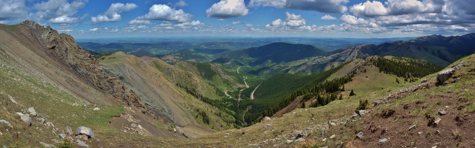
A colorful panorama to the east from the col at the head of the approach valley. From here, the more-direct “Roper Route” ascends straight behind us while an alternate route (the “Elk Traverse”) side-hills across steep scree/dirt towards an aesthetic bluff on the left. Click to see larger.
.jpg)
With an eye towards scouting the “Elk Traverse”, I made a quick jog across the steep scree and (of course) scrambled up the appealing bluff. Photo courtesy Grandpa.
.jpg)
Making my way back across the “Elk Traverse”. As you can see, the slope is steep and, with only a very narrow trail across it, hikers may be wary of the exposure. I figured that this traverse might be vertigo-inducing for some of the older and younger members of our group so we decided that the shorter “Roper Route” would probably be best.
.jpg)
Near a dirty snow patch, we started up steeper terrain towards the ominous-looking cliffs above. Photo courtesy Grandpa.
.jpg)
Grandpa, Grandma, Mera, Penny and Brianne hike up, angling to the climber’s left to stay on grassy terrain for as long as possible.
.jpg)
Brianne and her “Baby Bear” (who seems to have somehow escaped from her hiking carrier…).
.jpg)
Nannie and Papa gamely continue up (despite the obviously-steepening slope).
.jpg)
Penny delights in thrashing backwards and forwards in an effort to knock me off-balance as the grass keeps getting steeper and steeper. In preparing for this outing, I’d read a few trip reports but none of them accurately conveyed the steepness of the slope immediately below the rock band. This is probably because the reports were written by scramblers and, from a scrambler’s standpoint, this slope is child’s play. From a multi-generational hiking standpoint, however, it was pushing it! Confident hikers will have no issues here but it might not have been the best choice for a tot/grandparent outing. Oops! Photo courtesy Grandpa.
.jpg)
Brianne and Mera contemplate the best course of action atop the steep grass slope at the base of the rock band. Photo courtesy Grandpa.
.jpg)
A surprisingly civil family discussion. I figured I was D-E-A-D for picking this Father’s Day hike but everyone was surprisingly nice to me as they clung to the steep hillside (note Nannie doing just that below). I guess they had to be nice since it was Father’s Day? Photo courtesy Grandpa.
.jpg)
Since the steep grass slope already exceeded the acceptable-for-a-family-hike threshold, we decided to call it a day at the base of the rock band (about 20 vertical meters below the summit). Fortunately, the lovely view towards Windy Peak Hills, Saddle Mountain, Windy Peak and Mount Livingstone was the same from here as it would have been a stone’s-throw above. Photo courtesy Grandpa.
.jpg)
A quick photo of my hiking girls with the rock band. Although the cliff appears moderately fearsome, there are ledges that provide reasonably easy passage (just ask Roper!). Photo courtesy Grandpa.
.jpg)
Brianne carefully plots her descent. Although the slope doesn’t look absurdly steep in photos, it was steep enough that carrying 3-year-old Mera down seemed more prudent than allowing her to toddle down on her own. Photo courtesy Grandpa.
.jpg)
Nannie, Papa, myself, Penny, Crux, Brianne and Mera make our way cautiously down as the slope begins to relent. Photo courtesy Grandpa.
.jpg)
Salvation in the form of a flat perch near the dirty snow patch! Photo courtesy Grandpa.
.jpg)
Safely back to flat ground, Nannie shoot “the look!” Although Grandpa took this photo, I'm confident "the look" was intended for me!
.jpg)
Grandma was, likewise, happy to be down to mellower terrain. Pity she’d decided to leave her cell phone higher up on the mountainside…if you’re going to butt-scooch down a steep hill, you should probably make sure your new phone isn’t in your back pocket! Photo courtesy Grandpa.
.jpg)
Crux wonders why we’re not on the summit while Papa and I venture back up on a cell phone-hunt. Photo courtesy Grandpa.
.jpg)
Having successfully retrieved the missing phone, Penny and I decided to stretch our legs on a more reasonable slope. Mouse over to see 2 happy hikers! Photos courtesy Grandpa.
.jpg)
After regrouping and enjoying (another!) snack break, we started back down the lovely little ascent valley at a relaxed pace (despite the approaching thunderstorm which Nannie and Crux appear to have suddenly noticed).
.jpg)
Hmmm…there may be some hailstones falling on that butte…so much for the forecast 10% chance of precipitation! Fortunately, the storms all veered south and we didn’t add “getting soaked” to this Father’s Day’s list of missteps!
.jpg)
Near the trailhead, we captured a rare photo of the man who’s almost always behind the camera lens and not in front of it!
.jpg)
All’s well that ends well – and a day that ends with pineapple jalapeno IPA in the sun while collecting “monkey hugs” can certainly be said to have ended very well! It looks like my Father’s Day hike selection could still use some work but at least I know how to pick a good craft brewery! Thanks to the whole family for spending some quality mountain time with me! Next year, I promise to pick something less-steep! Maybe… 😈
.jpg)