I’M BACK.
After a 131-day mountain hiatus, a combination of forecast clear skies, low-moderate avalanche danger and an eager partner prompted me to get my butt in gear, and more importantly, up a mountain!
The adventure started (as it often seems to 🤔) when Matt Clay reached out looking for a mid-week alpine accomplice. I’ve really struggled to balance work, family and mountain outings recently so it came as no surprise that I had multiple commitments on the Wednesday in question. After consulting my weather and avi oracles, however, I decided to put ‘Operation-To-Hell-With-Everything-Else’ into motion! My boss begrudgingly granted a last-minute vacation day; I cancelled a dental appointment (with less than 24-hours-notice); and Brianne agreed to a day of single parent duty before a scheduled night shift. In short, I inconvenienced a lot of people and, given how it turned out, I’d do it again.
.jpg)
After discussing a number of potential peaks with Matt, he suggested Twin Cairns just west of Sunshine Village. While I’ve been to Sunshine many, many, many times (thanks to a previous life as a downhill skier), Matt had never visited the area during winter months so I happily agreed to play the role of ‘guide’ for him. Hoping to avoid the hordes that the resort attracts, we set off early and were rewarded when Sunshine staff directed us to the closest parking stall in the, oft-overflowing, lot (rockstar parking!). Matt and I couldn’t help but laugh at the irony of this coveted spot being given to a pair of backcountry free-loaders on snowshoes and cross-country skis. 🤣
.jpg)
.jpg)
LEFT: Setting off up the freshly groomed ski-out, Matt and I kept a brisk pace to cope with the -20 C temperatures. With clear, blue skies above, even frozen fingers and cold-induced asthma issues couldn’t dampen our spirits.
RIGHT: Mount Bourgeau catches the day’s first sun while valley-bottom temperatures and lighting resemble those on the dark side of the moon. If the sun won’t come to you, you just have to climb up to the sun, I suppose!
.jpg)
Stopping to consult a sign for directions. Photo courtesy Matt Clay.
.jpg)
After a relatively peaceful 90-minute trip up the deserted ski-out, we reached chaotically crowded Sunshine Village. Despite the cluster-f*ck of downhill skiers and snowboarders, the lure of a warm lodge proved too much to resist following our day’s frigid start. After a 30-minute break and a $10(!) breakfast sandwich, we plotted the most efficient escape route possible up “Prune Picker’s Pass” and made haste to escape the hordes (mouse over to see route).
.jpg)
.jpg)
LEFT: Thanks to packed ski runs, we easily hiked up between the “Standish” and “Wawa” chairlifts and caught our first glimpse of Twin Cairns to the west beyond the ski area boundary.
RIGHT: Donning snowshoes, we left the confines of the ski hill and embarked into the marvelous backcountry that surrounds it.
.jpg)
Twin Cairns took on a more foreboding air as we neared it. Knowing that other parties have ascended the northeast ridge (right), and noting a preponderance of ski tracks on it, we plotted a course in that general direction, sticking to the lowest-angled terrain possible (mouse over for route).
.jpg)
Upon reaching the base of the northeast ridge, however, we decided that this aspect was too steep for our liking. While the day’s avalanche forecast only called for “moderate” danger in the alpine, we knew that the consequences of any slide would be severe. Thanks to a deep, persistent (and unpredictable) layer, an avalanche on this slope would likely bring the entire 200+ cm snowpack down on us. Confronted by this risk, we beat a hasty retreat to safer ground to re-evaluate our route.
.jpg)
After descending below the likely runout zone of any avalanche, we made our way towards the more-distant northwest ridge which appeared to be more gentle. To get there, we plotted our own course, sticking to safer, low-angled terrain (mouse over for route). If you go up Twin Cairns, don’t mindlessly follow skin tracks as we spotted a number that needlessly crossed under steep, convex slopes.
.jpg)
Upon reaching the northwest ridge, we discovered a “rock garden” of sorts and stopped to take advantage of the photographic opportunities that it presented. I was especially pleased with this photo until I noticed the grinning chemist obscuring the otherwise lovely mountain scenery. 😝
.jpg)
.jpg)
LEFT: The sun rises over the northernmost high point of Twin Cairns. More gentle ascent slopes lie immediately out-of-sight to the right (west) of this photo.
RIGHT: The Monarch makes an impressive first appearance beyond the more gentle ascent slopes that we aimed for (mouse over for route). Once again, a previous skin track here needlessly ascended more hazardous terrain.
.jpg)
BEAST MODE! In the midst of a 131-day summit drought, I turned on the afterburners when I saw that the summit ridge was at hand. Photo courtesy Matt Clay.
.jpg)
The Ball Range makes for a spectacular backdrop as Matt, uncharacteristically, follows in my footsteps. To my recollection, this is the first of our many trips together where Matt hasn’t graciously taken on the entirety of the trail-breaking duties. As a result, I was pleased to finally return the favor (and even more pleased that snowshoe penetration was only 1 – 2 inches compared to some of the waist-deep sh*t-snow Matt has post-holed through to break trail for me)!
.jpg)
Upon reaching the ridge, we decided to explore the nearby north summit (even though we knew it wasn’t the ridge’s highest point). Photo courtesy Matt Clay.
.jpg)
The Monarch rises up beyond the first of, presumably, two cairns on Twin Cairns.
.jpg)
.jpg)
LEFT: The impressive cairn on the northern high point provides a study in contrasts: windward vs. lee.
RIGHT: Matt strives to gain that last extra meter of elevation (don’t tell him this is just a false summit anyways).
.jpg)
For a sub-summit, the northern high point offered an adequate panorama. Click to see larger. Photo courtesy Matt Clay.
.jpg)
Matt enjoys the midday sun from the northern high point with the true summit looming behind.
.jpg)
After our brief detour to the northern high point, we set our sights back towards the actual summit. From this angle, the ridge-top traverse looked relatively benign, however, the snow arête immediately ahead actually yielded a “spicy” moment or two! Photo courtesy Matt Clay.
.jpg)
A look at the somewhat-“spicy” arête and the nearby summit beyond. For some reason, the skin track ahead crossed, wind-hammered 40 degree slopes just below the arête. Confident that a slip here would not be arrested, we stuck to the crest itself which felt more exposed but offered a much greater potential to arrest any misstep or slide. I’d hoped to get a better photo of Matt crossing to show the exposure but I was too slow getting my camera out and Matt didn’t feel like obliging by waiting atop the day’s most dangerous point. Whether the above photo conveys it or not, this little section was a highlight as it granted an ‘alpine’ feel to an otherwise straightforward ascent.
.jpg)
Matt nears the summit. What goes up the arête must awkwardly come down a rocky prominence on its other side apparently!
.jpg)
.jpg)
LEFT: After a few entertaining ups-and-downs, we reached the summit of Twin Cairns under crystal-clear skies. We were greeted by a view that was well-worth reorganizing my schedule for!
RIGHT: Mount Assiniboine, “the Matterhorn of the Rockies,” highlights the view to the south.
.jpg)
A westward WOW. Click to see larger.
.jpg)
Twin Matts atop Twin Cairns.
.jpg)
Looking southwest towards the Simpson River Valley and the area devastated by 2017’s Verdant Wildfire. The larger peaks (from left-to-right) include: Octopus Mountain, Mount Harkin, Mount Daer, Lachine Mountain, Selkirk Mountain, Caitlin Peak and Split Peak.
.jpg)
A jet cuts through bright, blue skies as the nearby Monarch towers over snow-covered Eohippus Lake.
.jpg)
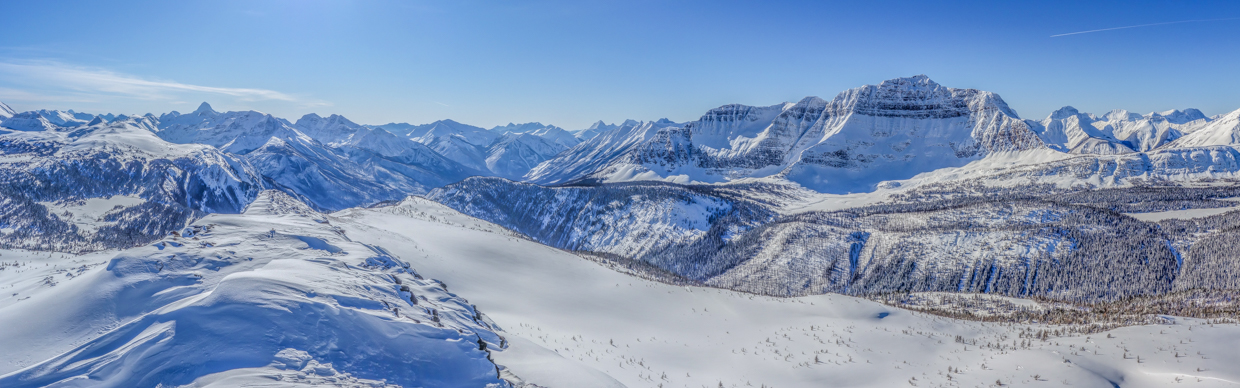
The spectacular panorama towards the Ball and more distant Vermilion Ranges. Click to see larger.
.jpg)
I’M BACK!
.jpg)
Massive Mounts Verendyre (left) and Floe Peak (right) tower above Hawk Ridge (center left) in Kootenay National Park.
.jpg)
The Monarch Ramparts rise up above forested alpine environs while larger Talc Peak (left) and Scarab Peak (right) provide a snowy backdrop.
.jpg)
Looking northwest over Healy Pass towards Banff National Park’s Egypt Lakes area.
.jpg)
Towering Mount Ball soars above the Pharaoh Peaks.
.jpg)
Alpine highlands stretch northward from the summit. Click to see larger.
.jpg)
Looking north towards Mount Brett (left), Black Brett (center left) and Mount Bourgeau (right). Diminutive Wawa Ridge is also visible at Bourgeau’s foot while Mystic Peak and Mount Ishbel can be seen through the Bourgeau-Black Brett col (Harvey Pass).
.jpg)
A telephoto shot down our, now-distant, approach valley towards Banff. The top of the “Wawa” chairlift is faintly visible at bottom-right. Visible peaks include (from left-to-right): Mount Cory, Mount Edith, Mount Brewster, Mount Aylmer and Cascade Mountain.
.jpg)
The expansive Sunshine Meadows stretch southward from the namesake ski resort into BC’s Mount Assiniboine Provincial Park. Click to see larger.
.jpg)
Officially-named Eagle Mountain (left), Mount Howard Douglas (center) and Brewster Rock (right) are, for some reason, referred to as “Goat’s Eye Mountain”, “The Eagles” and “Lookout Mountain” on ski hill maps.
.jpg)
A barely visible chairlift (bottom-right) provides a sense of scale when looking towards Mount Howard Douglas.
.jpg)
The Continental Divide runs along the Sunshine Meadows, splitting the provinces of Alberta (left) and British Columbia (right).
.jpg)
Gently-angled “Sunshine Landing” is dwarfed by “Little Fatigue” (which is anything but despite its name).
.jpg)
Citadel Pass sits between Nasswald Peak (center-left)/Golden Mountain (center) and Citadel Peak (centeright), marking the southern edge of the Sunshine Meadows. To the right, Mount Byng is visible beyond Mount Cautley and Wonder Peak.
.jpg)
.jpg)
LEFT: On top – again – at last!
RIGHT: After a rejuvenating summit stay, we were in no hurry to end our day so we decided to continue our traverse of Twin Cairns, descending via the scenic, wind-sculpted south ridge. In addition to adding variety to our day, this choice provided the benefit of allowing us to continue staring towards majestic Mount Assiniboine as we descended.
.jpg)
Easy scrambling is anything but when wearing snowshoes! Fortunately, the south ridge was gentle and the consequences of a fall were limited to embarrassment.
.jpg)
Ambling along the ridge with frozen fingers. After snapping too many photos atop Twin Cairns, I paid the requisite price for the first 10 – 20 minutes of our descent. Photo courtesy Matt Clay.
.jpg)
.jpg)
LEFT: Well-south of the summit, we stumbled upon the second “twin” cairn. Initially, its location struck me as odd (being on a point of no obvious prominence) until I noted…
RIGHT: …the geological survey marker immediately next to the cairn! The southernmost of the ridge’s “twin” cairns is located on the Alberta-BC border. Curiously, the summit of Twin Cairns didn’t sport either of its namesake cairns and was home only to an unimpressive mound buried by snow!
.jpg)
Matt pauses to soak in the views of the Simpson River Valley as we transition from rocky ridge to snowy meadows.
.jpg)
At a junction, Matt took the low road and I took the high road. Perspective is a funny thing as this roll was only 6-feet-tall (despite appearances to the contrary). Photo courtesy Matt Clay.
.jpg)
An idyllic snowshoe descent!
.jpg)
Quartz Hill and Ridge (center-left) rise up beyond lovely larch meadows.
.jpg)
An overlook granted pleasant views towards snow-covered Rock Isle Lake.
.jpg)
As we neared the network of summer trails, we quickly discovered a veritable highway of skin and ‘shoe tracks to follow, easing travel considerably.
.jpg)
Hoofing it back towards the ski area boundary on a well-packed trail.
.jpg)
.jpg)
LEFT: A descent into MADNESS. After a serene, rejuvenating day in the Banff backcountry, we were faced with the prospect of braving the Sunshine ski-out to get back to our car. Matt did so in boots while I furiously snow-plowed down on skinny cross-country skis. The experience was stressful and harrowing. Snowboarders, in particular, seemed to enjoy whipping by as close as they possibly could at speeds that would maim or kill. Based on my field observations, they appear to adhere to a code of conduct that emphasizes being the biggest douche possible.
RIGHT: While the day ended on a note of unpleasantness thanks to gravity-propelled morons, the scenery was still, undeniably, spectacular (if you moved slowly enough to notice it). We were granted a final sense of satisfaction as we returned to our rockstar parking spot and watched the erstwhile speed demons awkwardly shuffle with arms-full of heavy equipment a kilometer or more towards their vehicles at the far end of the, now-full, parking lot.
Downhill denizens aside, it was good to be BACK in my beloved Rocky Mountains!
.jpg)
.jpg)
.jpg)
.jpg)
.jpg)