The highest summit of the Pharaoh Peaks group is a relatively small peak surrounded by much larger ones and is, according to the little information that I could find, a straightforward walk-up via open south-facing slopes. Despite its location in the scenic center of the Egypt Lakes area, this peak appears to have been largely overlooked by the scrambling community. I’m not sure if it was the lack of online trip reports or the reputed beauty of the Egypt Lakes area but, for some reason, I found myself mildly obsessed with it.
Located in the middle of a popular backcountry area, numerous long approach options exist for access. The shortest of these routes (the approach via Healy Pass) involves a 13.7 km hike before the scrambling even begins. While a ~30 km return distance is not without precedent for a day trip, I really wanted to explore the Egypt Lakes area which this route only peripherally visits. After charting several different options on my Gem Trek map, I managed to convince myself that the longer approach via Redearth and Pharaoh Creeks could still be feasible as a day trip. This route would require a marathon distance (42 km) to get to and from Pharaoh’s ascent slopes but allowed for half that distance to be cycled. It also minimized unnecessary elevation gains and losses by not going over any passes. Finally (because this route wasn’t already long enough), it would grant the option to explore more of the area if I made the longer return trip via Shadow Lake instead of Pharaoh Creek.
.jpg)
Undeterred by the long road ahead, my trusty steed and I set out from the Redearth trailhead at 7:30am. Having not mountain biked in years, I made slow progress as the old fire road gained 300 vertical meters. When I told Brianne that I would be cycling the night prior, she worried about me surprising a bear at high speed. Rest assured Honey, I think I was going slower than I could have walked for a good deal of the bike ride up!
.jpg)
The sun rises over the shoulder of Pilot Mountain. Views during the initial 10.5 km bike ride were extremely limited with this counting as one of the finer ones.
.jpg)
The end of the road – for my bike anyways! Excited to be moving onto the next step in my journey, I locked up my bike and hastily started up the wrong trail. If I had taken a split second to look at the sign, I would have no doubt noticed that the Pharaoh Creek trail goes left here while the longer route to Pharaoh Peaks via Shadow Lake goes right. After hiking on the longer route for 5 minutes, I realized my error and retraced my steps, carefully read the sign and proceeded down the intended trail. Guess my day just got a little bit longer…OY…
.jpg)
If you intend to follow the Pharaoh Creek trail, you’ll encounter this warden’s cabin moments after the bike rack. If you don’t, you may be on the wrong trail…just sayin’.
.jpg)
Typical travel along the first 5 km of the Pharaoh Creek trail.
.jpg)
As I set out along the Pharaoh Creek trail, I found myself appreciating the mossy forest and the smaller details of the foliage underfoot. After 5 km without a view of anything but forest, however, I quickly tired of it!
.jpg)
Fresh bear scat – I wasn't the only one out on this trail for a morning stroll!
.jpg)
15 km from the trailhead, I was granted my first view of the day’s objective: Pharaoh Peaks. The south (left) summit is the highest of the three. From this point on, the terrain became a little more open, however, the views remained limited thanks to the valley walls to either side of Pharaoh Creek.
.jpg)
Sugarloaf Mountain rises up behind the shelter at the Egypt Lake backcountry campground. By this point in the day, I had already passed 3 backcountry campgrounds (a testament to the fact that few would consider this a single day trip). While scenery up to this point had been lacking, that was about to change in a big way!
.jpg)
After scenic starvation all morning, I gorged myself upon the vista from Egypt Lake! Sugarloaf Mountain is reflected in Egypt Lake’s outlet on the left while Scarab Peak rises up beyond a steep headwall on the right. Visiting the lake required a small detour from the main trail but I wasn’t going to hike marathon distances and not check out the lake for which the whole area is named! Click to see larger.
.jpg)
An impressive waterfall cascades down the sheer headwall at the far end of the lake.
.jpg)
Postcard-worthy views from my trip to Egypt (Lake).
.jpg)
A massive log near the lake’s outlet proved to be a good spot to sit down and enjoy my first lunch of the day.
.jpg)
Enjoying the view of Scarab Peak (left) and Greater Pharaoh Peak (right) from my log-top lunch stop. While it would have been nice to while away the day here, I still had many miles to cover and was soon back underway following the trail up the headwall at the base of Pharaoh Peak.
.jpg)
From the Egypt Lake campground, the well-travelled trail steeply switchbacks its way up the rocky headwall. Atop the headwall, the trail forks with 1 path leading up towards Whistling Pass and the other leading back down towards Scarab Lake. For Pharaoh Peak, avoid losing hard-won elevation and stick to the Whistling Pass trail…
.jpg)
…unless you’re a sucker for punishment like me and decide that the small detour and elevation loss to Scarab Lake are probably worth it! On the map, it looks like the main trail passes right by all of the Egypt Lakes, however, most of them actually require a short detour. Ah well…in for a penny, in for a pound I suppose.
.jpg)
Steep pockets of remnant snow cling to Scarab Peak above its namesake Lake. Scarab Lake was, apparently, the first geographical feature in the area upon which an “Egyptianized” name was bestowed. From there on, however, the Interprovincial Boundary Survey clearly got carried away! Click to see larger.
.jpg)
Making my way back up to the main trail from Scarab Lake. While regaining elevation sucked, the colorful wildflower display at the base of Greater Pharaoh Peak did help to ease the pain.
.jpg)
An Egyptian munches on wildflowers.
.jpg)
As the trail to Whistling Pass contoured around Pharaoh’s south aspect, the open slopes looked less daunting. In general, the further left (towards Whistling Pass) that you go, the gentler the ascent angle. By this time, however, I was tired and just decided to bash up from here.
.jpg)
Looking towards Whistling Pass as I pick my way up typical terrain on Pharaoh’s open south slopes.
.jpg)
During the ascent, a breathtaking panorama was unfolding behind me. The views were simply so good that I had to stop frequently to admire them (the stopping had nothing to do with the steep ascent or the 25 km that I’d already covered, I swear)! Click to see larger.
.jpg)
Paternoster lakes: Mummy Lake sits on an alpine bench just above much larger Scarab Lake.
.jpg)
As I gained height, the grassy meadows petered out and all that was left was the sub-summit slog.
.jpg)
Upon gaining Greater Pharoah Peak’s ridge crest, the view of glaciated Mount Ball is spectacularly revealed beyond the Middle Pharaoh Peak’s steep escarpment.
.jpg)
Success! 26 km from the trailhead, I finally topped out to spectacular views of the continental divide beyond Pharaoh Peaks’ summit cairn.
.jpg)
Always a pleasure to follow in Rick Collier’s footsteps (actually, it’s pretty tough not to in the Canadian Rockies)! From the entries contained in here, it would seem that one day ascents of this peak are pretty rare.
.jpg)
Rick got the first page of the register and I’m honored to lay claim to the last page. After signing it, I took it down with me to return to the ACC/Whyte Museum for archiving. If anyone’s heading up Pharaoh, please bring up a new register!
.jpg)
Three deep blue lakes lie at the confluence of green alpine meadows and the red rock of the continental divide. This may be the prettiest place that I’ve ever been. Click to more fully enjoy the scene!
.jpg)
Egypt Lake glistens in the afternoon sunshine. My lunch log looks pretty small now!
.jpg)
The continental divide spans the pass just beyond Mummy Lake. Across the pass, Hawk Ridge is the closest of the many BC peaks visible while aptly named Split Peak is apparent in the distant center.
.jpg)
With regards to scenery, Egypt Lake, Scarab Lake and Mummy Lake compete with the Monarch (left) and Scarab Peak (right) to steal the show.
.jpg)
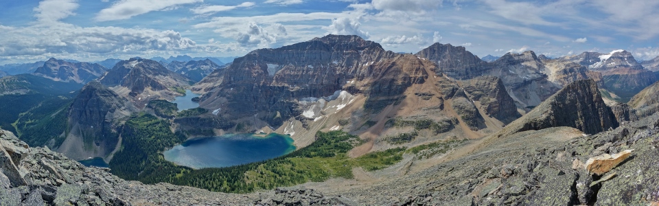
Pharaoh Lake (immediately below) drains into its namesake Creek which winds its way through the panorama back towards the Bow Valley (and the trailhead) some 20+ km to the north. To the left, the lesser Pharaoh Peaks and Mount Ball dominate the view while the vast alpine environs of Healy Pass and Sunshine Meadows stretch out to the right. Click to see larger.
.jpg)
The lengthy Castle Mountain massif in the distance.
.jpg)
A long way back to Copper Mountain. My bike is sitting somewhere along its base and my car is still 10.5 km from there! In the distance, snow-spotted Bonnet Peak is visible on the left while Noetic Peak and Flints Peak are the pointy summits on the far right.
.jpg)
Pharaoh Lake immediately below – one of the few lakes in the area that I opted not to detour to for a visit (I had to draw the line somewhere)!
.jpg)
Banff National Park’s own alpine Eden stretches out between Pilot Mountain on the left and Sunshine Village on the right. Click to see larger.
.jpg)
Pilot Mountain.
.jpg)
Mount Brett (left).
.jpg)
Harvey Pass and Mount Bourgeau; after today, Mount Bourgeau seems like a short day trip! Mount Girouard (the highest peak in the Fairholme Range) is visible to the left while Banff landmark Mount Rundle can be seen to the right.
.jpg)
Looking over Healy Pass towards Sunshine Village: Eagle (“Goat’s Eye”) Mountain to the left and Mount Howard Douglas (“Lookout Mountain”) to the right with Wawa Ridge in the middle ground. Not much snow left on “Delerium Dive” this time of year!
.jpg)
Mountain money shot! From left to right: the Monarch, Sugarloaf Mountain, Egypt Lake, unnamed (with a glacier no less), Hawk Ridge, Mummy Lake, Scarab Lake, Scarab Peak, Haiduk Peak, unnamed, Isabelle Peak, Middle Pharaoh Peak, Mount Ball, Lesser Pharoah Peak and Storm Mountain. Click to see larger.
.jpg)
Haiduk Peak beyond the red rock shoulder of Scarab Peak.
.jpg)
Tumbling Peak (distant left) and Isabelle Peak (distant right) on either side of an unnamed outlier of Haiduk Peak. Massive Mount Goodsir can just be seen far beyond the right side of Isabelle Peak.
.jpg)
Mount Ball beyond the lower Pharaoh Peaks. Both of the other Pharaoh Peaks appeared to be easy – moderate scrambles but, by this time, I was thinking less about bagging additional peaks and more about the long road home…
.jpg)
Mount Ball: one of my greatest epics in the Rockies.
.jpg)
The Banff version of Storm Mountain (right) beyond Baby Pharaoh.
.jpg)
On top of Pharaoh Peaks!
.jpg)
After nearly an hour spent soaking in the views and enjoying my second lunch, I begrudgingly started to make my way back down. On descent, I aimed for the col between Greater Pharaoh Peak and Middle Pharaoh Peak (far left) instead of going straight down the slope that I ascended. As I planned to exit via Shadow Lake, it made sense to angle as far towards Whistling Pass as I could to cut down on distance. Copper Mountain is visible in the distance down the Pharaoh Creek Valley to the right; my car is on the other side of it. OY…
.jpg)
From the col I found a lovely scree chute to plunge step down and I was back on the main trail in short order. Whistling Pass is just out of frame to the right in this photo and while I could have cut down on some distance by descending directly to it, that route would have been bouldery and less pleasant than the slightly longer combo of good scree run and easy trail.
.jpg)
From the trail, I had to make a very minor ascent up to Whistling Pass but from there on, it was all downhill!
.jpg)
Looking out over Haiduk Lake towards Mount Ball and Storm Mountain from Whistling Pass.
.jpg)
A closer view of the most northerly of the Pharaoh Peaks (lesser Pharaoh Peak); this one appears to be the most difficult of the three but an ascent of the obvious gully still looks to require only moderate scrambling.
.jpg)
Back amidst the wildflowers.
.jpg)
Mount Ball is reflected in Haiduk Lake as I work my way back towards the trailhead along its shores.
.jpg)
As with all of the other lakes in the area, the views from Haiduk Lake were sensational. This photo was taken looking back towards Scarab Peak (left) and Haiduk Peak (right); Whistling Pass is the low point on the far left. Click to see larger.
.jpg)
Haiduk Lake and Peak.
.jpg)
Pretty views but I think that the length of the day was wearing on me – by this point I could hear voices coming from the creek. Fortunately, they were singing opera (which I don’t even like) and not compelling me towards evil acts.
.jpg)
Fast forward passed a great deal of walking and I arrived on the grassy shores of Shadow Lake. Here I rested again and enjoyed my third lunch of the day.
.jpg)
A backlit Mount Ball towers above the far end of Shadow Lake. Even with the poor lighting, the scene here was spectacular! If I had been thinking, I would have walked in via Shadow Lake to enjoy the better morning light here rather than in the viewless forest along Pharaoh Creek. Click to see larger.
.jpg)
Shadow selfie.
.jpg)
A final glace towards behemoth Ball from the outlet of Shadow Lake. From here, the trail plunges back into thick forest for the remaining 14 km. OY…
.jpg)
Pretty flowers distract from the pain of a day gone too long.
.jpg)
Hallelujah!!! With the death march behind me, all that remained was a speedy 10.5 km bike ride back down to the trailhead. According to my GPS, I hit speeds of up to 42 km/h cruising down the fire road! While I had been ready to give up on life for the last few kilometers of hiking, the fast and fun ride down proved invigorating and allowed me to finish off the day on a really positive note.
.jpg)
52 km later…OY! In summary, Pharaoh: small peak, big day, IMMENSE views!
Walk Like an Egyptian (song) by sirnarnian
PS: You didn't think that I'd write up this whole trip report without a gratuitous Bangles reference, did you? Enjoy!
.jpg)
.jpg)
.jpg)
.jpg)
.jpg)
.jpg)
.jpg)
.jpg)
.jpg)