Towering majestically above beautiful Bow Lake, Crowfoot Mountain’s glacier-clad ramparts are one of the Icefields Parkway’s scenic highlights (and the competition is stiff on Highway 93N). It’s no wonder that the roadside pullout near its base is always filled with throngs of camera-toting tourists. Like them, Crowfoot awed my wife Brianne and I with its sheer faces and aesthetic icefalls. Indeed, we found Crowfoot so magnificent that we chose it as the backdrop for our wedding photos. Having long admired it, I’ve often thought about standing atop it and looking down, past the formidable glacier which occupies its impressive sub-summit bench, towards Bow Lake’s cerulean surface.
Obviously, I’d have to climb Crowfoot, but such a peak deserves an occasion. In 2016, on the eve of my 200th unique summit, I concocted a plan to ascend Crowfoot with Dr. Phil (despite an unfortunate dump of snow the night prior). Alas, steep snow slopes thwarted us a short distance below the false summit. As the years passed, Brianne and I often discussed celebrating our anniversary with an ascent of Crowfoot. Since we'd spent our first hours as a married couple at the peak's base, it seemed only fitting to celebrate our anniversary atop it! Year after year, however, our nuptial milestone was met with poor weather and lesser objectives. Still, I had no doubt that Brianne and I would eventually get our chance to enjoy Crowfoot together.
Then, last week, Brianne informed me (in the middle of a steep slope) that she no longer enjoys scrambling. It felt like the end of an era. By my count, we'd stood on 92 different peaks together (but who’s counting?). It’s been a big part of our lives, but lives change (especially once a pair of mostly delightful children are added to the mix). It seemed that the Crowfoot-climbing chapter of our lives had passed.
A week after I was forced to acknowledge that slogging up peaks was more of a “me” activity than a “we” activity, another milestone approached: my 37th birthday. I’m not into birthdays but I do enjoy using them as an excuse to get out to the mountains (because I’d never do that otherwise…). Even if she no longer had any interest in scrambling, my amazing wife knew how I'd want to spend my birthday (on top, of course!), so she told me to go climb something BIG. Since she was no longer interested in such adventures, I reached out to some of my more H-core climbing partners (yes Matt C., I’m calling you “H-core”).
Amidst of flurry of texts and messages to other scramblers, a curveball crossed my plate; my Mom offered to babysit our girls so that Brianne and I could go climb my birthday peak together. Of course, Brianne no longer wanted to scramble but, still, it couldn’t hurt to mention the offer to her, could it? Like the smart husband that I am, I broached the topic at the last minute as Brianne was leaving for a night shift. With the forecast finally looking like it was going to “play nice” for a Hobbs family milestone, I suggested Crowfoot…
To my great surprise, Brianne said "yes"(!). And so, as Grandma arrived at 6:00 am on August 2, my wife and I departed Crowfootwards.
.jpg)
After a remarkably pleasant (and coincidentally kid-free) drive, we arrived at Bow Lake. Before parking near the Num Ti Jah Lodge, we made a quick pit-stop at the Crowfoot pullout (along with a throng of tourists) to size up our objective. While Crowfoot’s northeast face is fearsome, its backside is much less-so (provided that you don’t mind circumnavigating this monstrous peak and the beautiful lake at its foot).
.jpg)
Brianne sets off around Bow Lake under uncharacteristically clear skies. We almost didn't recognize this beautiful area without freezing wind and snow squalls! 🤣
.jpg)
Mount Gordon, St. Nicholas Peak, “The Onion”, Bow Glacier and Bow Glacier Falls reflect in Bow Lake’s crystal-clear surface. Having not had a clear summer day at Bow Lake since our wedding 7-years earlier, I’d forgotten how magnificent it is!
.jpg)
.jpg)
LEFT: Clear, calm water slowed our pace as I stopped for photo after photo after photo...
RIGHT: Having recently joined Instagram, Brianne made the most of our scenic surroundings and was working her ‘Gram game.
.jpg)
.jpg)
LEFT: Vibrant fireweed along the lakeshore (because the lake wasn’t colorful enough on its own)!
RIGHT: After a week of unusually hot weather, many sections of the familiar Bow Hut trail were covered by lake and/or river! It seemed that the clear, sunny forecast which finally worked in our favor was not working in the favor of the glaciers above. Fortunately, the trail's popularity meant that forest by-passes were established and easy to follow (keeping our feet dry…for now).
.jpg)
After completing the hike around the lovely lake, we started up the outwash flats upstream of it, eventually following the trail up the side of a steep canyon.
.jpg)
.jpg)
LEFT: Brianne enjoys the view from the trail’s famous chockstone. This chockstone is a remarkable natural feature that has saved Parks Canada the cost of building one bridge. Pity they don’t reallocate those trail resources towards restoring other bridges that have washed out nearby...
RIGHT: The top of the chockstone provided a great view of the nascent Bow River, rushing down the canyon towards Bow Lake, the Bow Valley and, ultimately, Calgary.
.jpg)
.jpg)
LEFT: Beyond the chockstone-bridged chasm, the rugged trail passed through an annoying boulder field alongside a rushing, glacier-fed stream.
RIGHT: The source of the Bow River: Bow Glacier Falls. Thanks to the blazing hot August sun, the falls were flowing violently and their roar filled the, otherwise, quiet valley.
.jpg)
.jpg)
LEFT: Eventually, the trail turned sharply to the south, following Crowfoot Mountain’s long western flank up the side of, yet another, glacier-fed canyon.
RIGHT: Scenery abounds as the trail climbed steadily through alternating boulder field and forest. With a forecast high near 30 C and a strong August sun overhead, the shade of the latter proved especially welcome! At one point, we somehow managed to lose the main trail and mistakenly followed an unmaintained spur trail. This navigational blunder proved to be a small blessing as the denser, dew-soaked vegetation was remarkably refreshing!
.jpg)
Brianne stops for a quick and photogenic breather as the Wapta Icefield appears overhead. While the parking lot at Bow Lake was already overflowing when we arrived at 8:30 am, only a few groups ventured more than a stone’s throw from their cars and those that did were quite courteous, moving aside to allow COVID-appropriate distancing and some even wore masks. I suspect that these were guided groups on their way to or from Bow Hut. Regardless, it was nice to share the trail with courteous users (and nicer still to leave them all behind once our path parted ways with the official trail).
.jpg)
.jpg)
LEFT: About 6-km from the trailhead, the trail to Bow Hut crossed a significant stream and we stopped to enjoy our first “lunch” of the day. To the east of the stream, a verdant forest and alpine meadows adorned Crowfoot Mountain’s flank. To the west of the stream, a recently exposed post-glacial moonscape was present. After a buggy repast, we located a faint trail through the trees and left the official Bow Hut trail and all other human company behind.
RIGHT: Looking across the stream to the scenic but barren rubble field that eventually leads to Bow Hut.
.jpg)
.jpg)
LEFT: Brianne follows a faint trail upwards. After passing through dense trees for a few minutes, we reached the tree line and entered a spectacular alpine meadow.
RIGHT: Above tree line, a series of slabby cascades bisected alpine meadows and made for idyllic hiking.
.jpg)
Spectacular alpine views back towards St. Nicholas Peak and a very tiny Bow Hut (below the peak to the right). Despite the fact that we reached this amazing alpine environment only 10-minutes after leaving the main trail, I suspect that it is rarely visited.
.jpg)
.jpg)
LEFT: Leaving the hidden alpine meadows behind, we crossed a rushing stream and started up the glacier-carved basin on Crowfoot Mountain's west slopes.
RIGHT: Hiking up where once a glacier had been. This rubblescape proved to be a great testing ground for Brianne’s new hiking boots (which were just procured the night prior).
.jpg)
As we continued up the glacier-carved basin, Crowfoot Mountain’s false summit finally appeared to the southeast (center left). The true summit resides, unseen, 1.3-km beyond the obvious high point in this photo. While the hike up the basin looked like it might be a genuine rubblefuck, it actually proved quite pleasant! Indeed, we ascended glacier-smoothed bedrock that reminded me of a "sidewalk in the sky" for much of the day, and veered onto supportive snow when it suited our mood. Better still, the mosquitoes that tormented us below tree line proved no match for the icy breeze which flowed down from the, still unseen, glacier above.
.jpg)
An unexpected surprise! As we crested a rubbly rise, we suddenly found ourselves on the snowy shore of a brilliant blue tarn that collected at the glacier’s toe (click to see larger)! When I last ventured this way in October 2016, a desolate moat sat here. Clearly, the current situation represented a significant scenic upgrade! We were also surprised to find that the glacier sat between us and the false summit that we were aiming for (right). While the glacier looked benign, we opted to avoid it by detouring around the tarn and aiming for its east margin.
.jpg)
.jpg)
LEFT: As we rounded the colorful tarn, we spotted a recent track in the snow on the very edge of the glacier and aimed for it (thanks for breaking trail Cole!).
RIGHT: With rocky slopes a few meters to the left and glacial ice a few meters to the right, Brianne worked her way up a narrow strip of supportive snow which separated the two.
.jpg)
Despite swearing off scrambling only a week earlier, Brianne was all-smiles on this day. In fact, it was hard to be anything but jubilant when surrounded by so many natural wonders on such a perfect summer day! 🤩
.jpg)
Up, up we go. While the most commonly described scramble route up Crowfoot Mountain ascends towards the false summit at left, we opted to follow the gentler descent line that Matt Clay described in his 2019 trip report. To do so, we took a rising diagonal line up and to the climber’s right aiming for the exposed rock there.
.jpg)
Brianne enjoys supportive snow and a spectacular panorama below Crowfoot’s false summit (left) and above the glacier-covered Crowfoot-Vulture col (right). Beyond the col, Mount Balfour makes its first, dramatic, appearance. Click to see larger.
.jpg)
A tiny Brianne ascends massive terrain towards Crowfoot’s, still concealed, summit (far right).
.jpg)
.jpg)
LEFT: Beautiful, beautiful Balfour.
RIGHT: Rather than grovel up steep scree towards the summit ridge, we continued our rising diagonal line up, taking full advantage of the easy travel afforded by supportive summer snow.
.jpg)
.jpg)
LEFT: Upon cresting the ridge, Crowfoot’s summit finally appeared (about 5.5-hours after we’d last seen it from the car below). Don’t let anyone tell you that Crowfoot is a small undertaking!
RIGHT: Scouting the precipitous summit ridge for photo ops! Photo courtesy Brianne.
.jpg)
.jpg)
LEFT: Grinning ear-to-ear as we approach Crowfoot’s summit together. Less than a week after she swore off scrambling, it was both a joy and a relief to share another amazing mountain adventure with my wife. You can’t keep a good Goat down!
RIGHT: After contemplating an ascent of Crowfoot for years, Brianne finally enjoys one of the most spectacular vistas in the Rockies from its lofty summit.
.jpg)
A summit view worth the wait! To the south, a vast sea of glacial rubble and ice filled the panorama. Click to see larger.
.jpg)
To the east, the glaciated Three Brothers (center left) and Cataract Peak (center right) highlighted the view beyond Noseeum Mountain (middle ground) and Bowcrow Peak (foreground).
.jpg)
.jpg)
LEFT: Little Hector and its 11,000+ foot-tall namesake.
RIGHT: The Waputik Icefield sits atop an impressive glacial bench while a now-empty glacier-carved basin sits directly below Crowfoot’s sheer east face.
.jpg)
Familiar Bow Valley peaks and Lake Louise giants dotted the horizon to the south. From left to right: Storm Mountain, Panorama Ridge, Mount Bell, Mount Ball, massive Mount Temple, Mount Aberdeen, Pope’s Peak, Mount Lefroy, Mount Victoria, Mount Huber and Mount Biddle.
.jpg)
Mount Daly and the retreating Waputik Icefield.
.jpg)
Mount Balfour’s icefall-covered face provided a glimpse of how this whole area looked not long ago. Indeed, it's easy to imagine the bygone glaciers that once shaped this massive landscape.
.jpg)
A dozen or more tarns collect in glacier-scoured dips below Balfour.
.jpg)
A closer look at massive Mount Balfour and its impressive icefalls.
.jpg)
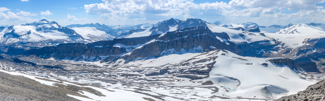
A wondrous, wintery panorama west over the Wapta Icefield. Click to see larger.
.jpg)
.jpg)
LEFT: Looking southwest towards Yoho National Park. The Vice President, the President and Mount Marpole pierced the horizon above the popular Iceline Trail.
RIGHT: Isolated Peak and Mount McArthur.
.jpg)
Mount Olive (center left), Vulture Peak (center foreground) and Mount Collie (center background) rise up beyond the cwm to the west.
.jpg)
The wonderful Wapta Icefield and its many peaks. Notable points include: St. Nicholas Peak (left), Mount Ayesha (center left), Mount Mummery (distant center left), Mount Rhonda (center), Mount Habel (center right), "the Onion" (foreground right) and Mount Baker (right).
.jpg)
Mount Forbes (the highest mountain in Banff National Park) and the Lyell Icefield appeared between more proximate Mount Thompson and Mistaya Mountain (center right).
.jpg)
To the northwest, eons of erosion have shaped a near-perfect summit panorama. THIS is the view that I’d been dreaming of since I first laid eyes on Crowfoot from the popular roadside pullout below; A vertical drop to the pristine Crowfoot Glacier followed by another plummet to beautiful Bow Lake below. Click to see larger.
.jpg)
Crowfoot’s (slightly lower?) north summit rises steeply above Bow Lake. The southern high point that we ascended is the official summit but it certainly doesn't seem to be much (if any) higher than Crowfoot's north peak! While the traverse between the two was enticing, we decided that Crowfoot south was a big enough day on its own!
.jpg)
The Icefields Parkway (Highway 93N) meanders over Bow Summit towards Saskatchewan Crossing. In the distance, the Wilson Icefield, many-towered Mount Murchison and more proximate Mount Weed are all visible.
.jpg)
Observation Peak (center left) and Cirque Peak (center right) rise up to the east of beautiful Bow Lake.
.jpg)
11,000er Mount Willingdon reared skyward beyond another one of Brianne and I’s amazing adventures: Dolomite Peak.
.jpg)
.jpg)
LEFT: Happy wife, happy life!
RIGHT: While I roamed the summit searching for photo opportunities, Brianne found the summit register (which read like a who’s who of Rockies peak baggers). While their many entries made for entertaining reading, it was this one which brought a tear to my eye.
.jpg)
The happy summit couple! To my wonderful wife: words cannot express how much this birthday adventure meant to me. Nevertheless, I’ll try to write something half as heartfelt as what you shared in the summit register. A week earlier, the thought that our scrambling adventures were coming to an end brought tears to my eyes. Today, on my 37th birthday, your summit smile brought me tears of joy. We’ve shared so many adventures together (including, most notably, parenthood). Through the good, the bad and the literal and metaphorical ups and downs, its your company that I enjoy most. Like you, I’m so glad that we got to go on another adventure together and I look forward to the many adventures that life holds in store for us both on top and elsewhere. The summit is merely a destination but it’s really the journey that I savor and there’s no one I’d rather journey with than you, my beautiful Breezy Goat!
.jpg)
After dispatching with the “mushy stuff”, Brianne decided that she’d had enough “adventure” and started back along the summit ridge. In an effort to get the most out of the spectacular view, we decided to follow the summit ridge north to the false summit and descend the more conventional scramble route from there. While the ridgetop views were outstanding, the descent from the false summit was, unfortunately, anything but…
.jpg)
The look on Brianne’s face suggested that she was not a fan of the steep, incredibly loose descent from the false summit. At one point, the entire rock slope actually started to slide down with her. She seemed thoroughly unimpressed when I suggested that she just jump off the rockslide in progress! Fortunately, she took my advice (and stuck the landing)! As unpleasant as it was, this slope only took 15-minutes to descend. Had it taken longer, I think Brianne may have sworn off scrambling for the second time in as many weeks! 😬
.jpg)
Back on snow, Brianne breathed a deep sigh of relief. A gloriously refreshing bum-slide ensued (although said slide may have taken us over a pocket glacier at one point…).
.jpg)
.jpg)
LEFT: Plunge-stepping down soft snow on the glacier’s margin proved much more pleasant than our steep scree descent had.
RIGHT: 😍😍😍
.jpg)
As we hiked down, the spectacular meltwater tarn which collected at the glacier’s toe glistened enticingly in the late-afternoon sun.
.jpg)
.jpg)
LEFT: With afternoon temperatures nearing 30 C, the tarn started to look like the world’s most spectacular swimming hole… Photo courtesy Brianne.
RIGHT: “Water’s ‘warm’ Honey! Come on in!” (Never mind the glacier.) Photo courtesy Brianne (who decided that no matter how hot she was, hypothermic would be too cold).
.jpg)
After a heart-stopping swim (ADRENALINE!!!), we resumed our descent, leaving the upper basin’s snow and ice behind and picking our way back down scenic glacial rubble.
.jpg)
.jpg)
LEFT: Brianne enjoys some unnecessary scrambling on remarkably grippy rock.
RIGHT: To no one’s surprise, the glacial stream that we’d crossed earlier was flowing much faster and deeper in the late afternoon heat. We spent a few minutes poking around for a good spot to rock-hop back across but, as you can see, the crossing’s end result was predictable regardless of where it occurred.
.jpg)
After seeing nothing but rock, ice, snow and water for hours, we began to notice colonizer plants, like these avens, amidst the rubble.
.jpg)
.jpg)
LEFT: Hearty avens welcome us back to “the land of the living” as we neared the end of Crowfoot’s glacial rubble field.
RIGHT: Soft alpine meadows felt amazing underfoot (even if said feet were now a ‘little’ wet)!
.jpg)
.jpg)
LEFT: Upon returning to the Bow Hut trail, we decided that we’d overloaded on scenery, so we put our blinders on and entered full-on GTFD mode.
RIGHT: Brianne carefully prepares to hop off the chockstone bridge.
.jpg)
Upon reaching the outwash flats upstream of Bow Lake, we were officially “down” the mountain. Unfortunately, there was still the small matter of hiking 2.5-km around Bow Lake to get back to the trailhead! As we trudged along the never-ending rubble flats, I could see Brianne leaning forward and squinting, trying to peer around the bend; When I witnessed this, I burst out laughing, for I knew exactly what she was looking for: Num Ti Jah Lodge’s bright red roof (which marked the trailhead – and the cooler of cold beer which awaited us there).
.jpg)
Hiking back around Bow Lake, Brianne did her best to look unimpressed but we both knew that this birthday adventure had been top-tier. Even with sore feet (23-km and 1350 vertical meters is a good way to break in new boots!), it was hard not to smile after the day we’d shared.
.jpg)
Upon returning to the still-crowded parking area, we enjoyed one of the most refreshing cold beers either of us could remember and watched as the late evening light lit up the Crowfoot Glacier. Sipping our victory NEIPAs, we couldn’t help but notice that the summit which we’d shared (distant high point above the righthand side of the glacier) looked really, really, ridiculously far away! Fortunately, the journey matters more than the destination and that long journey to Crowfoot’s summit gave me the best birthday present I could ask for: a lofty peak towering above a brilliant blue lake; a wild valley filled with ice and snow; a once-in-a-lifetime swim with a glacier; and, most cherished of all, another amazing alpine adventure with my wife.
Happy birthday to me!
.jpg)
.jpg)
.jpg)
.jpg)
.jpg)