Camping has become a favorite pastime of Penny’s this summer. She loves marshmallows. She loves playing with her sister in the woods. She loves her bunkbed in our camping trailer. But most of all, she loves being carried up mountains in her hiking backpack. While her older sister couldn’t wait to escape from the pack’s cozy confines, Penny has proven quite the opposite. When we asked her what her favorite thing was some time ago, she literally said “when Daddy carry me in backpack!” 🤦🏻♂️
Unfortunately for me, my little “Bear” is getting pretty big and carrying all 35 lbs of her is now a physically gruelling task. In an effort to get her to actually hike, we told her that she wouldn't be allowed in the backpack once she turned 3 and encouraged her to practice hiking "like a big girl."
As her third birthday approached, we organized a family camping trip to celebrate and made reservations in the Oldman Dam Provincial Recreation Area. Pandemic parties are a bit of a no-no but a long weekend filled with her favorite activities and favorite people was sure to be a hit with the birthday “Bear.” 🐻 Better still, she’d be able to squeeze in one final hike before our arbitrary, anti-backpack deadline came into effect!
.jpg)
Beautiful grasslands and towering turbines surrounded our campsite near the Oldman Dam in the province’s southwest corner. While this scenery was second-to-none, Penny immediately noticed the nearby mountains which looked well-suited for a final joyride in her well-used hiking backpack. Photo courtesy Gord Hobbs.
.jpg)
After reviewing several hiking options for Penny's backpack swan song, we drove south towards Castle Wildland Provincial Park to enjoy a hike up Carbondale Hill. To reach the trailhead, we followed signs for Castle Falls and parked at a roadside pullout 3 km from Highway 774. Once we geared up, we immediately tackled the hike’s first obstacle: a gate which prevents motorized access to the fire lookout above. While the grandparents made clever use of a small path around the gate, Mera and Penny both opted for a more head-on approach. 🤣
.jpg)
Penny practices hiking like a big girl with her Mom (to say that this did not last long is a COLLASSAL understatement)...
.jpg)
4-minutes into the hike, the birthday girl threw a fit and ended up in the hiking backpack. It’s going to be very “interesting” when we attempt our next hike without this Penny carrier… 😬
.jpg)
Once the tantrum-throwing toddler had been loaded onto my back, we continued up the fire lookout road. As we hiked, a proliferation of thimbleberry bushes provided a welcome distraction and allowed “Nannie” to demonstate her foraging prowess.
.jpg)
While the thimbleberries were a hit with Nannie, Penny loved them most of all (no surprise there since she’s our little “Bear”).
.jpg)
A colorful thistle. Of course, Mera had to touch it when we warned her that it was prickly. 🤦♂️
.jpg)
Caterpillar discovery. One of the things that I love most about hiking with my girls is their sense of wonder at so many of the natural things that I take for granted.
.jpg)
Mera and Mom enjoy the view (and a rest) from the hike’s first open area about 1.8 km from the trailhead.
.jpg)
After taking in the view, we started back up the forested fire road. Even though the hike was not difficult for 4-year-old Mera, “Papa” was still happy to lend a hand along the way.
.jpg)
Mera and Grandma enjoy more expansive Castle views as the road climbs above the tree line. Photo courtesy Gord Hobbs.
.jpg)
The Carbondale fire road winds its way through the ever-improving panorama. Click to see larger.
.jpg)
Papa takes in the view as the road crests Carbondale’s southeast ridge.
.jpg)
.jpg)
LEFT: Reenergized after a backpack catnap, the birthday girl insisted on coming out to finish the hike “like a big girl.”
RIGHT: The impressive Flathead Range looms beyond nearby foothills. Photo courtesy Gord Hobbs.
.jpg)
Carbondale’s parched upper slopes provided ample evidence that this August has been exceptionally dry.
.jpg)
With Penny out of the pack, my pace slowed to match hers. Mera, Nannie and Papa, meanwhile, continued up at a much faster rate, waving as they passed overhead on the final switchbacks.
.jpg)
.jpg)
LEFT: Brianne looks exacerbated as Penny becomes distracted by, yet another, unremarkable something. It was very nice that Penny wanted to hike the final stretch on her own but it would have been nicer still if she’d actually spent some time hiking (as opposed to running in circles chasing ants).
RIGHT: Unable to get Penny moving in the right direction, I offered her a piggy-back ride to the top. As you can see, she happily accepted. So much for hiking like a “big girl”…
.jpg)
With a “Bear” on my back, we made better time and soon caught up to the rest of our crew atop Carbondale Hill.
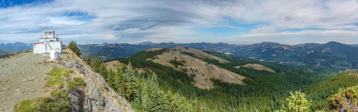
.jpg)
The foothill-filled panorama east from the Carbondale Lookout. Click to see larger.
.jpg)
.jpg)
LEFT: Another summit for Crux! While Crux has retired from scrambling, he still enjoys nice hikes (especially when said hikes are to cheeky summits that can pad his impressive totals).
RIGHT: Papa and Nannie also like nice hikes. Carbondale Hill was, however, a little too easy for Nannie so she decided to challenge herself by balancing on one foot whilst atop it? 🤷♂️
.jpg)
Looking north towards Crowsnest Pass, Crownest Mountain (left), Hillcrest Mountain (center left), Turtle Mountain (center left) and the Livingstone Range (center right) are easily recognized.
.jpg)
From whence we came: looking back towards the sea of prairies that surround the Oldman Dam.
.jpg)
Castle Peaks meet the prairies to the southeast.
.jpg)
Prairie Bluff (center left) is the most easterly peak in the area, Victoria Peak (center right) is one of the most impressive and Table Mountain (right) is, undoubtedly, the most popular.
.jpg)
A peak-filled Castle Wildland panorama stretches out to the south of Carbondale Hill. Click to see larger.
.jpg)
Looking into the heart of Castle, Southfork Mountain (left) and Syncline Mountain (right) bookend massive Mount Haig.
.jpg)
A closer look at Mount Haig and the Castle Mountain Ski Resort (which is located on Gravenstafel Ridge).
.jpg)
The Flathead Range’s jagged outline pierces the sky making for a dramatic panorama to the west. Click to see larger.
.jpg)
Mount Darrah (center left) was the most eye-catching of the many Flathead peaks visible.
.jpg)
Mount Coulthard (right) marks the northernmost reach of the Flathead Range.
.jpg)
Smiles all around on Carbondale’s scenic summit.
.jpg)
Penny celebrates Part 1 of her third birthday extravaganza with all of her favorite people!
.jpg)
After the requisite summit photos, snacks and bum-scooching (?!?), it was time to begin our descent. After all, we still had a birthday party to get to!
.jpg)
Having heard rumors that there would be a party back at the campground, Mera and Penny wasted little time descending Carbondale Hill… Of course, the birthday girl didn't manage to keep this pace for long and, soon enough, she was back in the (you guessed it) backpack!
.jpg)
Someone is rather pleased with herself after being carried and fed thimbleberries the whole way down the mountain…
.jpg)
Thimbleberries weren’t my jam so I treated myself to a more adult treat at the car. After carrying my heavy little almost-3-year-old all day, I think I earned it! 🍺
.jpg)
Back at the campsite, our little Queen Bear was all smiles as she enjoyed birthday presents 🎁 and treats 🎂 with her family. Having officially turned 3, we asked her if she was sad that she wouldn’t get to ride in the hiking backpack anymore. Without hesitating, she told us that she was “actually” turning 2 again and that pack rides were, therefore, still available to her. How do you say “no” to that (and how do you say “no” to that smile? Oh, my poor back…
.jpg)
.jpg)
.jpg)
.jpg)