Turtle Mountain
Elevation: 2204 m
Elevation gain: 900 m
Turtle Mountain is the site of the deadliest landslide in Canadian history. At 4:10am on April 29 1903, a massive block of limestone (425 m high, 1000 m wide and 150 m thick) weighing an estimated 82 million tonnes broke free from the top of the mountain and fell to the valley below at speeds reaching 112 km/h, burying the east side of the town of Frank. The Frank Slide, as the event came to be known, spread debris as far as 3 km away from Turtle Mountain and 120 m up the opposite side of the valley. The event resulted in at least 70 deaths and was heard over 200 km away in Cochrane. Prior to being named Turtle Mountain by local rancher Louis O. Garnett in 1880, the aboriginal people of the Crownest Pass had their own, ominous, name for the peak: “the Mountain that Moves.” It is said that the aboriginals were uncomfortable under the peak and never camped below it. The peak’s faulted anticline geology make it particularly susceptible to landslides as moisture enters the faults present on top, freezing and destabilizing the mountain’s weaker inner layers from within. Today, the mountain is closely monitored by a government of Alberta monitoring program which makes use of 80 monitoring stations.
My Ascents:
September 12 2010
With dismal conditions forecast for Calgary and the Bow Valley, Gord and I decided to make our way south towards the Crowsnest Pass in the hopes of finding better conditions and climbing Crowsnest Mountain (after 2 previous unsuccessful attempts). After a 3 hour drive, we arrived to discover that the poor weather had followed us. With the summit of Crowsnest Mountain firmly in the clouds, we opted to ascend nearby and smaller Turtle Mountain. Although Turtle Mountain had not been the original target, the ascent proved interesting both scientifically and personally. From a geological standpoint, the peak is amazing and we were awed by the power of the Frank Slide; although the event took place over 100 years ago, the devastation in the valley and on the peak looks as though it might have happened only yesterday. From a personal standpoint, the peak was very interesting as my grandfather Joseph Hlasny had been raised, the son of a coal miner, in the town of Bellevue just east of the Frank Slide. While the slide destroyed much of Frank, it also approached Bellevue, stopping less than half a km from the town’s present location. As a child, I remember my grandfather teaching me about the Frank Slide and recounting his ascent of Turtle Mountain (which was marred by a sunburn and excessive mosquitoes). The opportunity to follow in his footsteps up this peak is one that I count myself blessed to have had.
.jpg)
Not the ridge we were supposed to ascend...this is what happens when you ask a fat local man who looks like he's never even walked up his own stairs for directions to the trail-head...he points you in the opposite direction of the obvious, well-marked trail-head and you bushwhack up a steep slope instead. For those wishing to not repeat our error, start ascending Turtle Mountain at the northernmost edge of its north ridge.
.jpg)
After bushwhacking about 500 vertical meters, we finally gained the correct ridge...massive stress fractures in the rock along the ridge from the 1903 slide.
.jpg)
Looking down into the heart of the mountain through one such stress fracture.
.jpg)
Gord contemplating a fissure.
.jpg)
The ridge leading up to the summit. A labyrinth of deep fissures makes for some fun scrambling.
.jpg)
The mountain is wired for sound. And by sound, I mean movement. I suppose the geologists don't mess around after a mountain collapses on a town.
.jpg)
Trying not to set of the seismic equipment near the summit...definitely time for a diet if he does...
.jpg)
Where the town of Frank used to be...
.jpg)
The Crowsnest river cutting through the debris.
.jpg)
The Frank slide interpretive center at the base of the debris field.
.jpg)
Signing yet another register!
.jpg)
#30!
.jpg)
Father-son 'on top of a natural disaster' shot.
.jpg)
Wind power in progress over the prairies.
.jpg)
Seismic equipment lining the ridge towards the false summit. Numerous fractures along the ridge.
.jpg)
Entropy at work. Also the prairies.
.jpg)
Some perspective as to how large the boulders below are...moreover, the highway is well over a km from the base of the slide!
.jpg)
Artsy deadwood.
.jpg)
Gord tempting fate on a stress fracture in the rock.
.jpg)
For easier access, this mountain comes equipped with a heil-pad.
.jpg)
The Minister of sustainable resources apparently has no qualms about logging the crap out of this region.
.jpg)
We decided to continue south along the ridge from the summit for a different perspective of Frank slide.
.jpg)
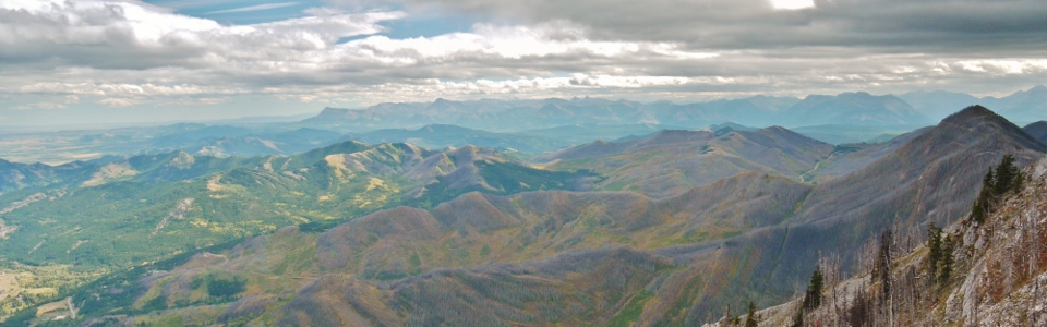
Looking south towards Waterton.
.jpg)
Up top I found a shovel which proved useful for ruining Gord’s self-timer summit shot!
.jpg)
The last thing they ever saw…
.jpg)
Mount Crowsnest and its perma-crown of cloud and the Seven Sisters across the valley.
.jpg)
Adventures in route-finding...whoops! I guess one should try to stick to the ridge…
.jpg)
Wondering how stable that rock bridge across the fissure is...
.jpg)
Looking back to the true summit from the false summit. To the left is where the mountain once was...
.jpg)
...and below is where most of the mountain now is.
.jpg)
Is that you God?
.jpg)
God briefly came down and told me to get new boots. Seriously.
.jpg)
Turtle Mountain and Frank Slide from the Interpretive center.