Everyone loves a good mystery. Some people enjoy reading mystery novels. Others like to speculate about unexplained phenomena. Personally, my favorite mysteries are mountain mysteries…
Some time ago, I stumbled upon a ‘whodunit’ that was too irresistible to pass up. Has anyone ever stood atop Mount Gloria’s highest point? Given that a first ascent was claimed almost 90 years ago, the answer would seem to be “of course”; however, when recalling his 1992 ascent of Gloria, the venerable Rick Collier noted his “doubts about what apex in the area is actually the true summit.” The peak that Collier climbed corresponded with the description of the summit the first ascenders had reached. Rick, however, noted that “there was clearly a higher point some 0.4 km to the NW across a broken ridge.” Having found a tin can with an “illegible set of records” inside the summit cairn and seeing “nothing of the sort on the higher more distant summit,” Collier reasoned that the higher nearby point must be an outlier of neighboring Mount Eon. As I consulted government topographic maps, however, the unclimbed (?) high point appeared to be part of Mount Gloria and slightly higher than the summit upon which Collier and the first ascenders had stood. Could it be that the highest point (and true summit) of Mount Gloria was, as yet, unclimbed?
.jpg)
The most detailed topographic map that I could find showed that Mount Gloria bears 3 distinct peaks above 2,800 m (circled). A 4th peak shows a listed elevation of 2,769 m. Based on his description, Rick Collier and the first ascent party climbed the peak circled in violet. The northernmost apex (circled in blue) appears to be of similar height while the summit circled in red features 1 additional contour line and would, therefore, appear to be at least 20 m higher than the other peaks (map courtesy Caltopo).
Based on the evidence available, it appeared that both the first ascent party and Rick Collier had failed to reach Mount Gloria’s highest point, begging another question: how feasible would it be to reach Gloria’s true summit? Collier climbed Gloria from Marvel Pass using an exposed 4th class ledge. Anything that Rick Collier considered 4th class, however, was likely to be way above my threshold for risk!
.jpg)
Fortunately, I had a good view of Mount Gloria from the nearby summit of Mount Alcantara some years earlier. As I examined my photos from that ascent, I became convinced that Mount Gloria’s south slopes could provide a less-technical route up. From my photos, it appeared that this route would grant access to the first ascent/Collier summit and, potentially, the higher true summit via a steep gully. The final true summit block looked like it might still present a challenge and the ferrocity of the bushwhacking in the valley-bottom could not be assessed from above but the rest of the route certainly looked feasible! Mouse over to see my proposed south slopes route (red) and Rick Collier’s more technical route (yellow) or click here for a higher resolution image.
Hoping to solve the mystery of Mount Gloria, I, therefore, reached out to fellow scrambling sleuths Andrew Nugara, Doug Lutz and Roland Roesler to see if they had any interest in this ‘case.’ Unable to pass up a good mystery, they all quickly committed to joining and we set out from Calgary at 4 am on July 29, 2018.
.jpg)
After a 3.5 hour drive, we reached the Aurora Creek Staging Area near BC’s Baymag Mine. While the road continued a little beyond the staging area, we opted to park there to take advantage of the “porcupine shields” left behind by others. Uncertain how fierce the upcoming bushwhack would be, we enjoyed a brief stint of easy hiking along the old logging road at the base of Eon Mountain before the real fun started.
.jpg)
After a couple hundred meters, the pleasant road disappeared and we ventured into the brush, paralleling Aurora Creek east towards our intended ascent route about 2 km away. Doug set a torrid pace into the tangle and the rest of us did our best to keep up. The bush wasn’t exactly pleasant but it was a far cry from the thrash required to ascend nearby Mount Alcantara.
.jpg)
An Indian Paintbrush adds a splash of color to our bushwhack.
.jpg)
Eventually, we reached a large boulder field which allowed for faster travel than the forest did. This opening also provided our first view of Mount Gloria’s east buttress (above the group’s heads) and the slope which we hoped to ascend on its near side.
.jpg)
A distant Mount Docking (left) appears down-valley as I make my way through the boulder field. Somewhere near this spot, we heard a large animal thrashing through the brush but couldn’t determine what we’d spooked. If my wife or mother ask, it was probably a (very large) chipmunk. Photo courtesy Andrew Nugara.
.jpg)
About an hour after we left the staging area, we reached the base of our intended ascent slope. From here, we wandered up steep but easy terrain where the rockier slope transitions to light forest.
.jpg)
Lower sections of the ascent slope featured a surprising preponderance of beautiful Blanket Flowers (Gaillardia).
.jpg)
Doug and I grind our way up as the already-hot morning sun beats down upon us (photo courtesy Andrew Nugara).
.jpg)
As far as slogs go, this one was at least scenic thanks to nearby Mount Alcantara.
.jpg)
Andrew stops for a photo-op (and a much-needed breather). For those who don’t know Andrew, he climbs mountains and, in his spare time, writes guidebooks about climbing mountains.
.jpg)
Roland enjoys more gentle terrain as we crest the steepest part of the slope and enter a large alpine amphitheatre.
.jpg)
Andrew attempts to locate Eon Mountain on his map (pssst – look behind you). Photo courtesy Doug Lutz.
.jpg)
Our ascent amphitheatre featured a couple of headwalls which were easily by-passed on the climber’s right.
.jpg)
An extremely unusual plant looks like something out of a science-fiction film! None of us could recall having seen anything similar on any other peak (and between the 4 of us, that’s a lot of peaks)! Subsequent research revealed that the plant is a Double Twinpod (Physaria didymocarpa) which is related to Mustard plants.
.jpg)
After by-passing a couple of headwalls and ascending grassy ramps, we reached a massive karst basin below Mount Gloria’s summit block. From here, we were granted our first view towards the true summit and the more commonly ascended east (Collier) peak. Mouse over to see each summit labelled.
.jpg)
Roland makes his way over glacier-scoured terrain towards Gloria’s summits (photo courtesy Andrew Nugara).
.jpg)
Very interesting and very overhanging cliffs on the north side of the sub-summit karst terrain. Presumably these features were carved by a glacier which no longer exists.
.jpg)
Roland pauses for a rest after crossing the entire karst basin.
.jpg)
A vibrant orange rock sits below Gloria’s true summit and the loose gully which we hoped to use to ascend it. Although the gully looked non-technical, the very steep terrain immediately above it caused both Roland and I concern.
.jpg)
The more frequently ascended (at least twice!) peak looked far more reasonable. It was at this point that our party split. With stamina and confidence waning somewhat, Roland and I opted to make our way up the sure thing while Andrew and Doug split off to explore the gully below the true summit. It was a little sad to split up after such a great morning together but this now afforded us the chance to measure the height of both peaks by GPS so that we could solve Gloria’s summit mystery once and for all!
.jpg)
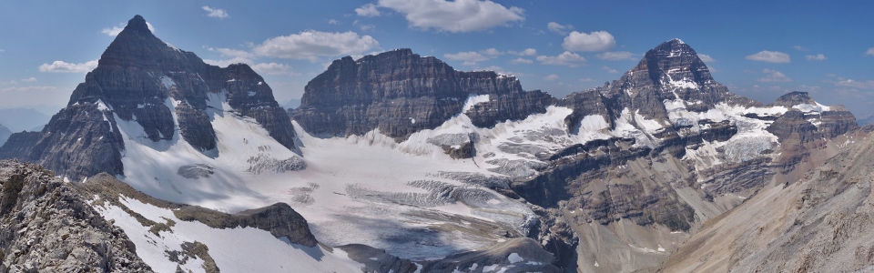
Mount Alcantara (left), Eon Mountain (center) and Mount Gloria (right) tower above the karst basin where once a glacier sat. Click to see larger.
.jpg)
Roland clambers up blocky talus while Eon Mountain rears impossibly skyward.
.jpg)
Are we having fun yet? While this terrain wasn’t exactly pleasant, it wasn’t frightening either and, after steepening somewhat, it led without incident to a summit (though perhaps not the summit)!
.jpg)
A “Marvelous” panorama to the east from a summit of Mount Gloria. Wonder Pass (left), Marvel Lake (center) and Marvel Pass (right) highlight the view beyond Gloria’s east-facing glacier. Click to see larger.
.jpg)
Looking north towards Mount Magog, Terrapin Mountain and the Towers.
.jpg)
A view literally filled with Wonder and Marvel: Wonder Peak rises above Marvel Lake.
.jpg)
Looking east beyond Marvel Lake and Peak towards Kananaskis Country.
.jpg)
Mounts Sparrowhawk (center left background) and Bogart (center right background) rise up beyond Cone Mountain (left middleground) and Mount Turner (right middleground) which, in turn, rise up beyond Marvel Peak (left foreground) and Penny’s Peak (right foreground).
.jpg)
Posing for a summit photo with a host of Marvel Pass peaks (from left to right: Cone Mountain, Penny’s Peak, Mount Turner, Mount Morrison, Mount Byng and Aurora Mountain).
.jpg)
Looking down towards Aurora (Cabin) Lake. If you look closely, you can spot the incomplete cabin and a helicopter which landed near the lake in this photo (mouse over to see).
.jpg)
The spectacular southern summit panorama. The snowy col immediately below us (center) is where Rick Collier ascended from while our group ascended from beyond the rocky plateau at far right. Click to see larger.
.jpg)
A lot of familiar peaks in one telephoto shot! From left to right: Mount Birdwood, Mount Murray, Aurora Mountain (foreground), Snow Peak, Mount French, Mount Curie, Mount Ware, Mount Sir Douglas and Mount Vavasour.
.jpg)
Massive Mount King George stands above all the other peaks in the distant Royal Group while Sharkfin (Talon) Peak and Mount Soderholm highlight the view to the right.
.jpg)
Mount Alcantara (center left), Eon Mountain (center right) and Aye Mountain tower impressively above the glacier-carved basin that we ascended. Click to see larger.
.jpg)
Eon, Aye and I!
.jpg)
Eon Mountain is a striking peak whose first ascent was marred by tragedy.
.jpg)
While Eon Mountain is impossibly sharp, its neighbor Aye Mountain features an equally impressive broad fin of vertical rock.
.jpg)
The “higher point some 0.4 km to the NW” somewhat obscures the summit panorama towards Eon Mountain, Aye Mountain and Mount Assiniboine at the head of the Marvel Lake (right) Valley. Click to see larger.
.jpg)
As we’d hoped, the summit of Mount Gloria provided an absolutely spectacular view of the mighty Mount Assiniboine.
.jpg)
Roland and I pose for our “group” summit photo. Having not been on an outing together in over 4 years, it was great to get out with Roland once more!
.jpg)
Buried deep in the summit cairn, we discovered the tin can that Rick Collier described after his 1992 ascent of Gloria. Could this have been left behind by Gloria’s first ascent party in 1929?
.jpg)
The oldest surviving record of ascent which we found on Gloria’s east summit: a faded entry dating back to 1956!
.jpg)
The register which Collier placed in 1992 was wet but in, otherwise, decent condition allowing us to enjoy a chuckle while reading Rick’s register entry which starts: “at least I hope this is Gloria”! The other laugh that the register prompted was the sticker on the front cover with instructions on where to return it once full. The 26 years between Rick’s ascent and our own saw only one other party reach the summit so I doubt anyone will be carrying a full register off of Mount Gloria in the near future!
.jpg)
Documenting the elevation of Gloria’s east summit. With 2 different GPS units, Roland and I recorded near-matching summit elevations of 2,865 ± 1 m (well shy of the 2,908 m officially-listed height).
.jpg)
Having established the elevation of Gloria’s east summit (which was claimed by both the first ascenders and Rick Collier), we turned our attention to the higher point to the NW where we could see Doug and Andrew ascending steep terrain. Mouse over for a closer look towards the 2 intrepid explorers amidst a sea of steep, chossy rock.
.jpg)
Mount Assiniboine bears witness as Doug and Andrew reach the highest point (and therefore true summit) of Mount Gloria. Doug and Andrew reported that their GPS units recorded the height of this peak as 2,900 - 2,920 m, suggesting that the officially listed height of 2,908 m is accurate and irrefutably confirming that this peak is the true summit of Mount Gloria. Mouse over for a closer look. Now to answer the mystery of Mount Gloria’s actual first ascent: Had Doug and Andrew successfully gone where no one had before?...
.jpg)
…Nope! Unless the wind blew this very old sardine can up to Gloria’s true summit, Doug and Andrew were following in the footsteps of at least one other party. But who else had been up here (and who on Earth brings sardines along as a hiking snack?)! Photo courtesy Andrew Nugara.
.jpg)
Inside the old sardine can, Doug and Andrew discovered a single record of ascent from a climb that occurred almost 84 years earlier! On September 2, 1934 Lillian Gest and her guide Christian Häsler had stood upon the true summit of Mount Gloria and were quite likely the first to accomplish this feat. Subsequent research revealed that Lillian Gest was a remarkable woman who laid claim to several first ascents in the Rockies (most notably: Mount Bryce) and, in her later years, wrote 3 books outlining the history of different regions in the Rockies. After learning more about Gest, I’m in awe of her accomplishments. Sadly, the world can be quick to forget remarkable people who are no longer with us. Fortunately, some of them left bits of themselves behind on old, weathered papers in sardine can summit registers so that we would know who we had the privilege of sharing a beautiful summit with. Cheers to Lillian! Photo courtesy Andrew Nugara.
True summit or otherwise, Mount Gloria has seen remarkably few ascents. From the records which we collectively discovered, Gloria has been ascended by the following individuals:
• 1929: C. Baldwin, E. Bigelow, F.X. Bigelow, H. Bigelow, H.B. Bigelow, S. Detty, G. Duffy, R. Hallowell, H.Howe, C. Saltonstall, R. Saltonstall, R. Walcott and C. Coyteaux. First recorded ascent (which appears to have been of the lower eastern peak).
• 1934: Lillian Gest and Christian Hasler. Possible first ascent of Mount Gloria’s true summit.
• 1956: Douglas L. Kerr (east peak).
• 1992: Rick Collier (east peak).
• 2014: Vivien Bowers, Dave St. Denis, Cheryl Gwillim and Glenn Cameron of the Kootenay Mountaineering Club (east peak).
• 2018: Matt Hobbs, Roland Roesler (east peak), Doug Lutz and Andrew Nugara (true summit).
Interestingly, Doug and Andrew found Lillian Gest's register entry protected by a plastic baggie. Doug wondered if plastic bags even existed in 1934 and found that they were patented in 1931 and that "Saran" was invented in 1933. This means that Gest and Häsler could have wrapped their register entry in plastic but, given the timing of their ascent, it seems equally likely that a subsequent mystery party may have done so to preserve the FA record. If that is the case, we'll likely never solve the mystery of Gloria's second ascent...
.jpg)
Doug takes in the mind-bending (and rarely glimpsed) panorama from the true summit of Mount Gloria (photo courtesy Andrew Nugara). Click to see larger.
.jpg)
Roland and I enjoying the east peak as seen from Gloria’s slightly higher true summit. Mouse over for a closer look (photos courtesy Doug Lutz and Andrew Nugara).
.jpg)
An awe-inspiring glacial bench rests at the base of Mounts Eon, Aye and Assiniboine. Sadly, this extensive field of ice was not fully visible from the east peak and failing to see it firsthand is my only regret. Fortunately, Doug and Andrew were good enough to share their photos so that Roland and I (and now you) can bear witness to its beauty (photo courtesy Doug Lutz). Click to see larger.
.jpg)
As good a view of Mount Assiniboine as there is (photo courtesy Doug Lutz)!
.jpg)
Doug and Andrew atop the true summit of Mount Gloria; a possible second ascent! Photo courtesy Doug Lutz.
.jpg)
Meanwhile back on the east peak, Roland daydreams of knee-jarring rubble. Fortunately, he’d get his share of it in a few moments when we began our descent back towards the karst basin below.
.jpg)
♫ Reunited and it feels so good! ♫ Catching back up with Doug and comparing ascent/summit notes below Gloria’s twin peaks.
Doug and Andrew reported that their ascent was "non-technical" but said they "wouldn't call it scrambling" based on the steepness, looseness and exposure. Andrew in particular mentioned that the ascent gully was the scariest such feature he'd ever been in and both seemed just as pleased to be back on solid ground as they had been to attain the summit in the first place! Photo courtesy Andrew Nugara.
.jpg)
Since we’d failed to share a single summit, we made sure that we at least took a good sub-summit group photo. The smiles you see all around were generally representative of, what was, an awesome day out with great company!
.jpg)
After debriefing each other and enjoying a brief rest, we turned our attention towards the remaining 1,100 vertical meters of descent.
.jpg)
An unnamed outlier of Red Man Mountain provides nice views as we continue downwards. The fact that this 2,800 + meter peak is unnamed is a testament to how infrequently this area must be visited!
.jpg)
Pleasant views from equally pleasant descent slopes (photo courtesy Doug Lutz)!
.jpg)
Roland takes advantage of a particularly idyllic place for a nap. On descent, his strategy seemed to be “run down the mountain so that I can nap while everyone else catches up.” Photo courtesy Andrew Nugara.
.jpg)
As my toddler would tell me: “Careful of the dropoff Daddy!” While the mountain’s lower slopes steepened significantly, they were, fortunately, quite easy to descend.
.jpg)
Taking advantage of reasonably soft dirt, we were able to descend the steepest sections with relative ease.
.jpg)
Aurora Creek cascades down a steep headwall below the unnamed peak north of Red Man Mountain. By this point, we’d all, more or less, exhausted our supply of water and were looking forward to a cool drink from the fast-flowing creek.
.jpg)
After refreshing ourselves at the creek, we opted to cross it and attempt to gain the Marvel Pass/Aurora Creek trail on its far (south) bank. We knew that this good trail would quickly return us to the staging area where we’d parked. The last mystery of the day, however, was: how bad will the bushwhack to the trail be? As you can see, it got pretty bad! Indeed, the trail was only 530 m from the creek but it took us over 20 minutes to cover that ground, likely negating any time which we may have made up along it. On the way in, our 2.2 km bushwhack required an hour and on the way out our 0.5 km bushwhack and 1.9 km on-trail hike required…1 hour! In short, I wouldn’t really recommend the Marvel Pass trail as the bushwhack below Eon’s south slopes wasn’t really that bad anyhow. At least we solved another mystery…
.jpg)
A cold(ish) beer at the staging area provides an exclamation point, bringing to a close another spectacular day in the magnificent Canadian Rockies! Having enjoyed ourselves immensely and solved many of Mount Gloria's mysteries, all that was left was to remark: “Gloria, Gloria!”
"Gloria! Gloria!" (A final thanks to Andrew and Doug for ensuring that Laura Branigan was stuck in my head for days after our ascent!)
.jpg)
.jpg)
.jpg)
.jpg)
.jpg)
.jpg)
.jpg)