With Aunty Di making her annual pilgrimage to the Canadian Rockies, I was tasked with selecting a spectacular, family-friendly objective to remind her of why she should move back home from the left west coast. Having previously taken Di up Fairview Mountain, Cirque Peak, Pocaterra Ridge and Mount Wilcox, the “scenery” bar was set pretty high; nevertheless, having made a solo ascent of Snow Peak last year, I was confident that the beautiful Kananaskis views (both en route and on top) would rival anything else in the Rockies.
.jpg)
An overcast start to the day at Mud Lake near the Burstall Pass trailhead. Although the forecast called for rain (and a fair bit of it – 15 mm!), we opted to attempt Snow Peak anyways since July 21 was the only day that the whole family (+ Grant) were available for an outing. Since when has the forecast ever been right anyways?
.jpg)
After a rather pedestrian (in more ways than 1 since we didn’t bring bicycles for the approach) hour hiking through the forest, we arrived at the gravel outwash plain from the Robertson Glacier. I’m not sure why the Park decided to place a bridge here, since there are no others through the labyrinth of creeks that follows! Fortunately, a series of signs has been erected in the hopes of guiding hikers through the outwash and onwards to Burstall Pass.
.jpg)
Snow Peak reveals itself beyond the outwash.
.jpg)
Thanks to a series of gravity-defying Chuck Norris-style leaps, we made our way across the many streams without wetting our boots.
.jpg)
Hmmm…crossing this last stream may require a particularly epic leap (hint: go left and look for logs – you can still leap across them if you want).
.jpg)
Emerging from the forest into a flower-filled alpine meadow.
.jpg)
Mom and Aunty Di stop for photos with Mount Birdwood (not to be confused with Mount Butterscotch).
.jpg)
After the outwash, the trail does a strange thing – it actually starts to gain elevation (the first several km of trail are disappointingly flat). The result: beautiful alpine views! This particular view is looking back down the approach valley towards Mount Galatea (left), Gusty Peak (center) and Mount Chester (right).
.jpg)
After hiking for 7.4 km and 450 vertical meters, we reached the stunning alpine environs of Burstall Pass (featuring Whistling Rock Ridge on the left and Mount Sir Douglas on the right). The panorama from the pass is so fine that it’s a worthy destination in its own right. One could spend days exploring in every direction from here! Click to see larger.
.jpg)
Hobbs family photo at Burstall Pass (with honorary family members Aunty Di and Grant).
.jpg)
From the pass, Snow Peak, Mount Birdwood, Pig’s Tail and Commonwealth Peak form a single file line down the valley. Click to see larger.
.jpg)
Mom poses with Snow Peak. Unfortunately, at this point our group decided to split up. With Gord’s back causing him grief all morning, he and my mom opted to stay at the pass and explore while Aunty Di, Brianne, Grant, Crux and I continued up the right-hand ridge towards the summit of Snow Peak.
.jpg)
Crux shows the girls the way across the first snow patch as the views of Burstall Pass below become more and more impressive.
.jpg)
Crossing the same snow patch (this photo was taken by Gord from a “slightly” different angle back down at the pass).
.jpg)
Leman Lake, Sharkfin Peak and Mount Soderholm come into view to the west. The latter two are in BC while the former is still in Alberta.
.jpg)
Aunty Di monkeys around on a steeper bit.
.jpg)
A persistent snow patch just below the summit. While this patch looks somewhat innocuous, it’s deceptively steep and runs out over a series of rock bands. Complicating matters, the cold temperatures had resulted in a good overnight freeze making the traverse somewhat treacherous – one would not want to slip here. Since I was the only one who had brought crampons and an ice axe, the group rested here for 15 minutes while I cut steps across the snow with my axe’s adze. Once my “highway” was complete, the group quickly but carefully scampered across the snow to the summit.
.jpg)
Crux and I enjoy the summit with 2 of our favorite ladies.
.jpg)
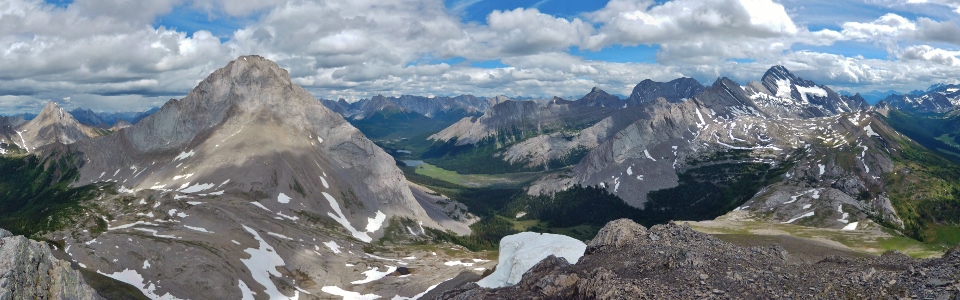
The panorama from the summit of Snow Peak does not disappoint! For a relatively small peak, the views truly are grand! Click to see larger.
.jpg)
One can spend hours on top of Snow Peak picking out other summits. To the north (from left to right): Mount Morrison (background), Mount Turner (background), Smutwood Peak, Mount Shark, Cone Mountain (directly behind Shark), Mount Smuts, Old Goat Mountain (background), Mount Nestor (background), the Fist, Mount Lougheed (background) and Mount Sparrowhawk (background).
.jpg)
Slabby west faces of Mount Birdwood (left) and Mount Burstall immediately to the east.
.jpg)
Looking beyond the outwash flats that we crossed several hours earlier towards a variety of familiar peaks including (from left to right): Mount Chester (background), Mount James Walker (background), Mount Inflexible (background), Mount Potts (distant background), Kent Ridge North Summit (background), Mount Evan Thomas (distant background), Mount Burstall, Mount Packenham (distant background), Mount Hood (distant background), Mount Brock (distant background), CEGNFS, Mount Murray and Mount French.
.jpg)
A good chance to catch up with Grant (foreground) and the British Military Group (background).
.jpg)
Nearby Mount Sir Douglas is over 600 meters higher than Snow Peak and is the highlight of the view from the summit.
.jpg)
Snow Peak may only be a few hours of hiking from the highway but it grants views of some wonderfully remote areas featuring towering peaks and rarely visited lush green valleys. Click to see larger.
.jpg)
Mount King George (distant left) and Mount Queen Mary (distant center right) tower above Mount Cradock (center left), Mount Back (center), Mount Queen Elizabeth (directly in front of Mount Back) and Mount King Albert (center right).
.jpg)
Finally able to enjoy another summit with my beautiful wife! After a slow start to her scrambling season, I look forward to many more peaks with her before the snow returns!
.jpg)
Mounts Eon (left) and Assiniboine (center) beyond one of several cornices atop Snow Peak. Despite the poor forecast, it never did rain on us and, as you can see, the visibility was surprisingly good in every direction!
.jpg)
Grant enjoying a scenic outing in the Rockies.
.jpg)
Group summit photo.
.jpg)
After a short stay on the summit, we carefully retraced our steps over the steep snow patch and began to make our way back down to the pass where Gord (with his sore back) and my mom were patiently waiting.
.jpg)
Enjoying the beautiful greens of the valleys and passes below on descent. Click to see larger.
.jpg)
…Meanwhile back at the pass: the folks pass the time by enjoying the views of Mount Leman, Sharkfin Peak, Mount Soderholm, Mount Leval, White Man Mountain and Mount Vavasour.
.jpg)
Unbeknownst to us, however, Gord decided that his back wasn’t THAT sore anymore so they started up the peak around the time that we were heading down to meet them at the pass. As the terrain steepened, my mom decided to call it a day while Gord continued up the ascent ridge hoping to run into us as we made our way down. Instead of retracing our steps down the entire ridge, however, most of us had opted to take advantage of some excellent scree skiing to the skier’s right and, therefore, managed to completely miss Gord and my mom. Grant, who didn’t see the scree run, ran into them but no longer knew where we were. All in all, the situation could best be described as a total cluster fuck with members of our group ending up scattered all across the mountain!
.jpg)
Once we reached the alpine meadows well below the peak, I began to scan the mountain using my camera’s zoom hoping to figure out where Grant had ended up. Imagine my surprise when I spotted Gord (who was supposed to be waiting back at Burstall Pass) high up on the mountain all by his lonesome! I wanted to get everyone back on the same page at this point, so I made my way back up most of the peak (finding Grant and my mom en route) before intercepting Gord just below the summit. Together we made our way down and managed to get everyone back together by the time that we reached Burstall Pass.
.jpg)
“What an awful selfie. But, then again, there was no one else up on the summit to take my photo.” – Gord later said in a tone reminiscent of Eeyore.
.jpg)
All-together again, we made our way back to beautiful Burstall Pass before starting the long hike back to the car.
.jpg)
Crux looking somewhat sad (Gord’s Eeyore tone must have been contagious) at the prospect of having to cross the outwash flats and their myriad of streams again.
.jpg)
To hell with balancing on logs and leaping over streams – it’s been a long day – let’s get down!
.jpg)
Last views of the Robertson Glacier, nestled between Mounts Robertson (left) and Sir Douglas (right). From here on, an hour of unremarkable hiking brought us back to the trailhead following another scenic excursion with Aunty Di.
.jpg)
.jpg)
.jpg)
.jpg)
.jpg)