A day after completing an ascent of Forum Peak and the full traverse of Akamina Ridge (1300 vertical meters and over 20 km round trip), Brianne and I were ready for more punishment – this time at the hands of Mount Crandell. Mount Crandell is not much to look at and, as a result, had never really been high on my “to-do” list. That all changed the instant, I saw Vern Dewit’s panoramic summit photo. For a peak that isn’t particularly impressive-looking from below, Crandell packs quite a punch. We decided to ascend via the moderate “Tick Ridge” approach and found the route to be challenging. Moreover, the “easy” descent route proved more challenging than anticipated as well. I found Kane’s descent directions difficult to interpret and the photo in the guide book is of no help from the summit. We later discovered that the Parks Canada information center offers a pamphlet with details of the routes up and down Mount Crandell (complete with a topographic map) and I highly recommend picking one of these up if you’re planning to climb this peak. The weather also contributed to our difficulties as the hot July sun beat down upon us and dehydration and sun stroke became issues as the day wore on. In hindsight, the view alone makes this peak worth ascending, however, it should not be underestimated!
.jpg)
Mount Crandell as seen from the Waterton townsite. The more difficult Bear’s Hump approach is visible in the center (the ridge dividing the sun from the shade) while our chosen route, the moderate Tick Ridge approach is the right-hand skyline ridge.
.jpg)
The Boss making her way up Tick Ridge. The name of the ridge had me paranoid and checking myself for unwanted passengers all day. Just one more charming thing about this ascent!
.jpg)
The "no nonsense" route. Straight up. The lower sections of Tick Ridge proved mercilessly steep under the hot sun.
.jpg)
After climbing about 400 vertical meters, the rest of the Tick Ridge ascent route comes into view.
.jpg)
Although the terrain was unpleasant, the view more than compensated - at least according to me! Brianne may beg to differ...
.jpg)
The upper section of Tick Ridge is a jumbled mess of pinnacles etc. making it quite scenic. It also makes the scramble more interesting as you get higher.
.jpg)
Using a window in the rock to spy on the guests at the Prince of Wales hotel.
.jpg)
Great views of the peaks across Waterton Lakes (from left to right: Sofa Mountain, Vimy Peak, Mount Boswell, pointy Miche Wabun and Mount Cleveland).
.jpg)
From Tick Ridge, it feels like you're looking straight down on the Prince of Wales hotel. Come to think of it, that's not far from the truth!
.jpg)
Finally the summit comes into view near the top of Tick Ridge. As you can see, there's still a fair bit of ground to cover as the summit lies well north of Tick Ridge. You can also make out the crux of the ascent, the cockscomb ridge, in the upper left of the photo.
.jpg)
Looking down on the Waterton townsite and the alternate more difficult Bear's Hump approach from the junction between the two routes. In my opinion, the best views of the entire scramble are right here! I wish I'd taken some panoramic shots here because the views weren't as nice from the summit. Next time maybe...
.jpg)
Great view of Sofa Mountain and Vimy Peak towering over the prairies.
.jpg)
Chief Mountain to the south-east in Montana.
.jpg)
From the top of Tick Ridge the view of the Akamina Parkway peaks is spectacular. From left to right: Mount Lineham, Mount Hawkins, Mount Blakiston (the highest peak in Waterton) and Ruby Ridge in the foreground.
.jpg)
The challenging cockscomb ridge separating us and the summit. The "easier" route goes along ledges to the left before ascending to the ridge crest once it is "preferable" to do so. The more difficult route? Straight along the cockscomb. After seeing Vern Dewit's trip report photos, I had no desire to even attempt the cockscomb so Brianne and I quickly headed climber's left to try to avoid the wrotten looking ridge. Although most of the difficult terrain can be dodged in this way, you will still need to cross an exposed section of the cockscomb to get to the summit. Don't confuse "easier" terrain with "easy" terrain! It's all relative up here.
.jpg)
The terrain below the cockscomb isn't particularly friendly either. Once the difficulty becomes upper moderate, it's time to regain the ridge. Here Brianne tries to find a moderate way back up to the cockscomb.
.jpg)
An airy traverse.
.jpg)
Looking back along a section of the cockscomb that was, surprisingly, preferable to the ledges below at this point. This section was unavoidable but mercifully short.
.jpg)
After the cockscomb, the rest of the route is merely a walk. A long, excruciatingly hot walk under the beating July sun with no hint of wind (VERY unusual for Waterton). The summit panorama was spectacular and featured from left to right: Sofa Mountain, Chief Mountain, Vimy Peak, Mount Boswell, Miche Wabun, Mount Cleveland, Waterton Lake, Citadel Peak, Mount Richards, Bertha Peak, Mount Alderson, Mount Carthew, Buchanon Ridge, Akamina Ridge, Long Knife Mountain, Mount Rowe, Mount Lineham, Ruby Ridge, Mount Hawkins and Mount Blakiston. Click to see larger.
.jpg)
Modeling the latest in summit fashion: the MEC turban used in an attempt to counteract the effects of the sun and heat.
.jpg)
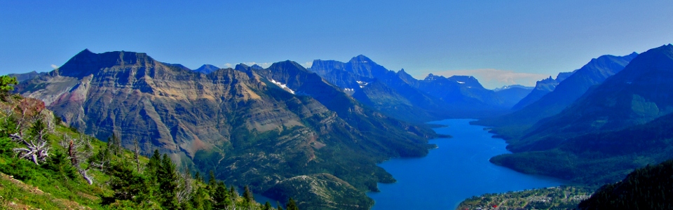
Beautiful Waterton Lake. Mount Cleveland is the prominent peak behind the lake. Citadel Peak is the oft-photographed craggy peak to the right of the lake.
.jpg)
Mount Cleveland (right) is the highest peak in Glacier National Park dominates the view to the southeast.
.jpg)
Looking south towards Akamina.
.jpg)
The peak with the coolest name in the area (and Brianne's favorite): LONG KNIFE PEAK!
.jpg)
The popular Carthew-Alderson trail. Mount Alderson on the left above Alderson Lake; Mount Carthew on the right. The trail descends the pass between the two peaks and connects Cameron Lake to the Waterton townsite.
.jpg)
Summit panorama to the north and east. Mountains give way abruptly to prairie. Click to see larger.
.jpg)
Mount Glendowan, Cloudy Peak and Mount Dugarvon form an impressive barrier to the prairies.
.jpg)
The aforementioned prairies. The south-facing descent route visible in the foreground.
.jpg)
Company on the summit. We didn't see any businessmen up here but we did see these guys.
.jpg)
Exhausted summit shot. All out of water thanks to the strong sun, lack of wind and HOT weather. Too bad that lake isn't a little closer...
.jpg)
Taking her rage out on the summit cairn. The Boss wasn't the hugest fan of Mount Crandell. By the end of our thirsty descent, I would start to feel the same way.
.jpg)
They looked hot too.
.jpg)
The "gentle" (in some places) south-facing descent slopes provide another great view of all of that cold, refreshing water way down in the valley. If I sound thirsty, it's because I was. This is the thirstiest I've been since Mount Fullerton last year (where I had to hike out 12 km in the sun without any water left).
.jpg)
Make it stop...or at least make it rain :(
.jpg)
Despite the thirst, we made it back. Enjoying the view of our peak from our campsite.
.jpg)
After all that whining about water: guess what I find at the bottom of my backpack when unpacking it the next day?
.jpg)