Akamina Ridge and Forum Peak
Elevation: Akamina Ridge - 2575 m, Forum Peak - 2415 m
Elevation Gain: Akamina Ridge - 929 m (Note: Kane lists elevation gain along the entire ridge traverse as 1300 m), Forum Peak - 769 m
In the Kootenai dialect “Akamina” means “benchland”. In geology, benchlands are long narrow strips of relatively level ground bound by distinctly steeper slopes above or below. Based on these criteria, round-topped Akamina ridge, with its steep walls is aptly named. Geographically, this long ridge is an important barrier, separating Alberta, British Columbia and Montana. While Forum Peak appears to tower above Cameron Lake from below, it is actually little more than an outlier of Akamina Ridge.
My Ascents:
July 21 2012, August 20 2011
Trailhead: Akamina Pass Trailhead
The end of July marks my favorite time of the year. Scrambling season is in full swing and the more interesting peaks have usually rounded into form. The days are long and the valleys are lush and green. It simply doesn’t get any better than late July scrambling! It was with this enthusiasm, that Brianne and I elected to escape to Waterton National Park for a long weekend. Brianne has been lucky enough to see a reasonably large cross-section of the Rockies in the 3 – 4 years since she moved to Calgary (What can I say? I’m a good tour guide), however, we had never managed to make it down to tiny Waterton Park. Wanting to show her the best that the park had to offer, we decided to ascend Akamina Ridge on our first day in the area. I hiked up Akamina a year earlier and, being suitably impressed by the grandeur of the views along the spectacular traverse, wanted to share the experience with Brianne. Having found the hike up a little tame, however, we decided to challenge ourselves a little more and attempt Kane’s scramble route this time around. What the hell – while we’re up there, may as well bag Forum Peak and claim the two’fer too!
.jpg)
Forum Peak, as seen from the south end of Cameron Lake.
.jpg)
The cut line through the trees denotes the BC-Alberta border and serves as the approach for Kane's scramble route up Akamina Ridge. This bit was beyond steep.
.jpg)
Finally through the thickest part of the cut line, the forest thins and begins to offer spectacular views.
.jpg)
One of the locals.
.jpg)
One of the benefits of following Kane's ascent route was the spectacular view of Cameron Lake at the foot of Mount Custer in the United States.
.jpg)
The American side of Cameron Lake: surprisingly snowier than the Canadian side...
.jpg)
The scramble route was carpeted with glacial lilies.
.jpg)
Boss on the border.
.jpg)
People have been vandalizing these border markers since 1946! I hope for their sakes that the cut line was thinner back then...
.jpg)
Finally getting to the fun stuff! Soistheman rates this rock band as difficult, however, we found it quite simple and pleasant 50 m to the right.
.jpg)
First glimpses of Forum Lake below.
.jpg)
Brianne breezing up a rock chimney.
.jpg)
For reasons that no one will ever understand, the cairn and summit register on Akamina Ridge are ~300 vertical meters below the summit on the eastern-most portion of the ridge. The summit can be seen a long way off in the distance on the right.
.jpg)
Having problems getting into the register; looks like somebody needs to hit the weightroom!
.jpg)
Lower Waterton Lake is faintly visible (as is the cut line denoting the Canadian-American border) to the east from this point of the ridge.
.jpg)
Craggy peaks carved by glaciers on the American side.
.jpg)
Looking west into BC and Montana along Akamina Ridge.
.jpg)
Kintla Lake bracketed by Kinnerly Peak and Long Knife Peak.
.jpg)
Testing the sturdiness of the "summit" cairn.
.jpg)
Having nearly knocked over the cairn on Akamina Ridge, we opted to pay a quick visit to the United States on nearby Forum Peak.
.jpg)
It's hard to believe that this bump (located 5 minutes from the low point on Akamina Ridge) counts as a summit, but the cairn, register and topographic maps make it official. Looks like we got a two'fer before we even got the the summit of Akamina!
.jpg)
Mount Chapman behind Mount Custer in Glacier National Park. Cameron Lake in the valley below and Wurdeman Lake beyond.
.jpg)
Summit shot ~300 m below the summit!
.jpg)
Cameron Lake and the smaller Akamina Lake in the distance from the summit of Forum Peak.
.jpg)
Pleasant strolling along Akamina Ridge.
.jpg)
More "impressive" peaks to the south beyond a small Canadian cornice. Pocket Lake in the valley below.
.jpg)
Boulder Peak and some spectacular spires beyond.
.jpg)
Peak wild flower season; as if Waterton isn't colorful enough with its plentiful red, green and yellow rock.
.jpg)
Mount Peabody, Kintla Peak and Kinnerly Peak beyond Gardner Point in the States.
.jpg)
A beautiful hanging valley where a glacier once lived.
.jpg)
One happy goat in front of Waterton's colorful array of peaks.
.jpg)
The highest peak in Waterton National Park, Mount Blakiston, beyond the yellow summit of Mount Lineham.
.jpg)
Lush valleys at the western foot of Mount Custer.
.jpg)
On the road again...still not at the ridge's summit yet!
.jpg)
The Boss' favorite mountain of the day (and that was before we knew that it had such a wicked name): Long Knife Peak.
.jpg)
Finally on summit approach!
.jpg)
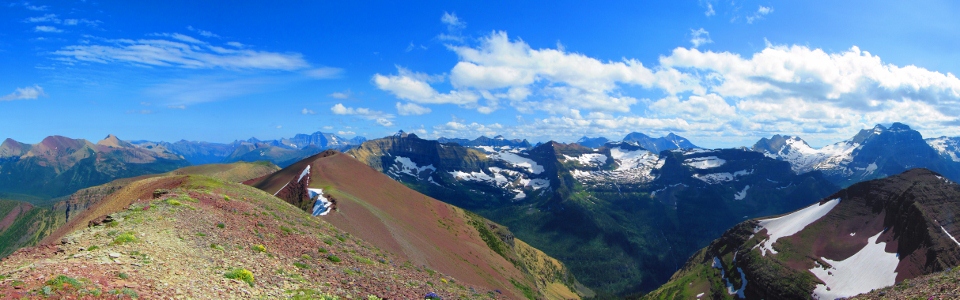
Spectacular summit panorama.
.jpg)
I had heard that there were many goats in these hills, but had no idea they were so beautiful ;)
.jpg)
Summit rock garden.
.jpg)
Red Mount Carthew and yellow Mount Alderson on the Albertan side of things.
.jpg)
Brianne and I in front of LONG KNIFE PEAK. Such a cool name...
.jpg)
No register on the real summit but she still found a way to leave her mark...
.jpg)
Wall Lake a long way below.
.jpg)
Mount Kinnerly above Kintla Lake.
.jpg)
The remnants of the Agassiz Glacier.
.jpg)
Wall Lake tucked in at the base of Akamina Ridge.
.jpg)
Akamina's steep north face protects a surprising amount of snow for late July.
.jpg)
Beargrass!
.jpg)
Scenic Wall Lake. A tedious plod back to the van followed. Many a foot ached and many a sigh was uttered.
.jpg)
Happy ending!
.jpg)