Tangle Ridge
Elevation: 3000 m
Elevation Gain: 1100 m
Tangle Ridge was named by Mary Schaffer in 1907 as a result of the difficulties that many early parties encountered while attempting to descend Tangle Creek to the north. Despite the name, the ascent of the ridge itself is straightforward and, almost entirely, above the tree line making it an ideal location from which to take in the views of the surrounding icefields.
My Ascents:
August 4 2011, September 18 2010
Trailhead: Tangle Creek Falls Parking
Tangle Ridge is a spectacular and easy scramble. Indeed, the entire ascent can be completed hands-in-pocket and the grade is generally quite gentle. As an ascent, therefore, it can be a little dull. Why do people come up here, then? THE VIEW. I’m hard-pressed to think of a single scramble in the Canadian Rockies (or elsewhere) which can match this one for breathtaking panoramas in every direction. To make matters better, the vast majority of the route lies above the tree line and the entire ridge can be traversed so you can spend hours savouring this view! Ever since they saw my photos of this view from my ascent last year, my parents have been adamant that I return to the ridge with them. On August 4 2011, Gord’s 63rd birthday, I was ecstatic to be able to take them both up Tangle Ridge under clear blue skies.
.jpg)
Only 10 minutes past the trailhead, we were greeted by a stunning view of Mount Andromeda. From here on, the views only get better!
.jpg)
After being forced to stay off of her feet for 3 months following surgery on her foot, my mom certainly looks pleased to be back on her feet in her Rocky Mountains!
.jpg)
Thinning trees eventually lead to pristine alpine meadows with spectacular views of Mounts Kitchener and Stutfield. The angle of the alpine meadow here gives you a good idea as to what the ascent angle generally is on Tangle Ridge.
.jpg)
The birthday boy making his way up the gentle upper scree slopes of Tangle Ridge.
.jpg)
Glacial debris at his feet.
.jpg)
The Kitchener and Stutfield Glaciers pour down into the Sunwapta Valley in a spectacular icefall.
.jpg)
Clear skies overhead!
.jpg)
Million dollar view.
.jpg)
As we approached 10,000 feet elevation, my mom started to notice the thin air so, in addition to my services as guide, I also lent a hand as a porter for the summit push.
.jpg)
The 63 year old, however, was fuelled by the panorama and burned up the slopes to the summit!
.jpg)
Almost there...rare views of Mount Alberta provide the final bit of inspiration necessary to get to the top!
.jpg)
When we arrived at the summit, we found the photographer hard at work.
.jpg)
The other end of the previous photo.
.jpg)
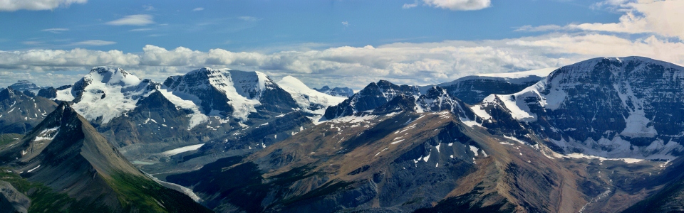
Spectaculr icefields panorama, from left to right: Mount Saskatchewan, Mount Wilcox, Mount Athabasca, Mount Andromeda, the Snow Dome, Mount Kitchener, Mount Columbia and Mount Stutfield. Click to see larger.
.jpg)
Looking back down the valley towards the Athabasca Glacier and the "Columbia Icefields" that most park visitors are familiar with.
.jpg)
Mount Columbia, the heart of the icefield, is visible beyond the icefall between Mounts Kitchener and Stutfield. At 3747 m, Columbia is the 2nd highest peak in the Canadian Rockies and the highest in Alberta.
.jpg)
Close up of Mount Columbia.
.jpg)
Getting ready to sing 'Happy Birthday'.
.jpg)
The long tongue of the Athabasca Glacier (bottom right) and Sunwapta Lake below giants Athabasca and Andromeda.
.jpg)
A snow bus ascends the Athabasca Glacier.
.jpg)
Wide angle shot of the Sunwapta River Valley to the north.
.jpg)
Mount Alberta is the high point of the Winston Churchill Range to the northwest.
.jpg)
At 3619 m, Mount Alberta is one of the most challenging climbs in the Canadian Rockies.
.jpg)
Panorama from Columbia to Alberta! Click to see larger.
.jpg)
The North Twin, also higher than 3700 m, was visible.
.jpg)
Thick ice on the Snow Dome.
.jpg)
Jets crossing paths above the apex of the continent.
.jpg)
The awesome icefall that is the Kitchener Glacier.
.jpg)
Mount Wilcox looks positively diminutive in front of giants like Mount Saskatchewan (distant), Mount Athabasca and Mount Andromeda.
.jpg)
Despite its small stature relative to its neighbors, Wilcox is an awesome scramble!
.jpg)
Taking in the sea of peaks through his lens.
.jpg)
A chilly lunch break.
.jpg)
Mounts Amery (left) and Saskatchewan (right) to the south.
.jpg)
He looks like he's having a happy birthday!
.jpg)
The Brazeau Range to the east. Sunwapta Peak on the left, and many unnamed peaks on the right.
.jpg)
A distant Mount Brazeau and Sunwapta Peak.
.jpg)
Mount Brazeau.
.jpg)
Looking south to Wilcox Pass.
.jpg)
Nigel Peak and Wilcox Lake to the south.
.jpg)
One last family photo before heading down...
.jpg)
Where we have to get back to! Highway 93 and the Sunwapta River in the valley below.
.jpg)
Unintentional glissade.
.jpg)
The ridge was littered with great fossils. Everytime my mom wanted a breather she pretended to be prospecting for fossils. Let's just say she found quite a few!
.jpg)
Rubble giving way to meadows giving way to trees, eventually giving way to highway.
.jpg)
Last views of Andromeda and Athabasca from just above the highway.
.jpg)
Tangle Falls at the trailhead after an amazing day on Tangle Ridge. I really can't recommend this scramble enough!
.jpg)
.jpg)