Mount Wilcox
Elevation: 2884 m
Elevation Gain: 940 m
Mount Wilcox was originally named Wilcox Peak in 1924 before the name was changed to Mount Wilcox in 1928. In 1956, the peak’s name was officially changed back to Wilcox Peak, however, it is still most commonly referred to as Mount Wilcox. Regardless of whether or not it is a “peak” or a “mountain”, it is named after Walter Wilcox, an early explorer in the Canadian Rockies. Wilcox’s party was the first to reach Sunwapta Pass in search of a pass by which the Athabasca River could be reached. Wilcox, along with Robert Barrett are credited with the first ascent of Mount Wilcox (or is that Wilcox Peak?) in 1896.
My Ascents:
August 2 2011, September 1 2007
Trailhead: Wilcox Pass Trailhead
Day 2 of the birthday scrambling extravaganza! While my actual birthday isn’t until August 3, I wasn’t going to let that stop me from bagging a peak on August 2! While climbing Mount St. Piran a day earlier, Brianne and I concocted a brilliant scheme to go for 3 peaks in 3 days leading up to my birthday (OK, maybe I had more to do with that scheme than her…). Brianne hasn’t ever scrambled in the Icefields Parkway, so we decided upon Mount Wilcox since it (as Kane puts it) “offers possibly the best view in the entire Rockies for the energy expended.”
.jpg)
Early views of the Dome Glacier from Wilcox Pass. Slightly inclement weather, but not too bad. Kane suggests that this ascent be made directly from the Columbia Icefields Visitor Center, however, I’m forced to disagree with him. During a previous ascent, I followed his advice and, while the steep grassy ascent from there is shorter, it is not pleasant. Walking through Wilcox Pass, on the other hand, is heavenly. While the Wilcox Pass ascent is 2 – 3 km longer, it is much easier and you make much better time on the well-maintained “highway” of a trail. The Wilcox Pass trail allows you to combine one of the most spectacular hikes in the Rockies with one of the best scrambles in the Rockies. Why would you deprive yourself of that?
.jpg)
The boss making her way across a stream in the pass. Little A Glacier in the background. See what I mean regarding the views from Wilcox Pass?
.jpg)
My shorts have seen better days...
.jpg)
Apparently stepping on a mushroom in a mossy pass can be quite a terrifying experience.
.jpg)
The objective: Mount Wilcox, steep, slightly exposed and fun from the snow patches on.
.jpg)
As we gained elevation, the weather improved dramatically (it usually works the other way around)! It's as though the weather Gods knew it was my birthday (tomorrow). Nice views of the Snow Dome, the hydrographic apex of North America.
.jpg)
Breathtaking views of the Athabasca Glacier from Wilcox Pass. Even if you don’t scramble, Wilcox Pass is an easy hike that is ASBOLUTELY worth doing!
.jpg)
Head down, nose to the grindstone...it's not that bad, is it? :P
.jpg)
Enjoying the ridge after the wide open meadows of Wilcox Pass.
.jpg)
Avalanche on Mount Kitchener!
.jpg)
We found a lost scrambler along our way and took him in for the day. Here, Brianne shows him the way up the first of the hands-on-scrambling. From here on, the scrambling is as fun as the views are spectacular!
.jpg)
Brianne took this shot of me arriving at the false summit from the true summit. You can see how close the two are but there is some mild exposure separating the two of them!
.jpg)
Great little ledge on the last part of the ridge. There's an airy km between myself and Highway 93 below to the left! Holding on VERY tight!
.jpg)
Narrow bit between the false summit and the true summit.
.jpg)
After narrow bits in the previous 2 photos, it's a quick walk to the top! As you can see, the view from the top is outstanding!
.jpg)
What a view! Mounts Kitchener and Stutfield across the valley.
.jpg)
The North Twin and the Twin Tower between Mounts Kitchener and Stutfield. For an amazing view taken from Vern Dewit’s ascent of the Twin Tower, click here.
.jpg)
Looking down the Sunwapta River Valley. From left to right: Stutfield Peak, Mount Cromwell, Mount Engelhard, Mount Alberta (behind Engelhard), Mount Wooley, Diadem Peak and Mushroom Peak.
.jpg)
Mount Alberta (3619 m) just visible above and behind Mount Engelhard.
.jpg)
An airy kilometer between us and the Sunwapta River/Highway 93 below!
.jpg)
Looking back to the false summit from the true summit: Mounts Saskatchewan (distant), Athabasca and Andromeda.
.jpg)
Athabasca and the 'Little'-A Glacier.
.jpg)
Looking south to Wilcox Pass and the Icefields Parkway towards Mounts Cirrus, Coleman and Wilson.
.jpg)
The aptly named Snow Dome.
.jpg)
A snowy Sunwapta Peak to the north.
.jpg)
Nigel Peak: I sat atop there and enjoyed a similar panorama exactly 364 days earlier (on my 27th birthday). Wilcox Lake at its base.
.jpg)
Brianne and I loving the views of the Athabasca Glacier.
.jpg)
The rarely spotted Mount Bryce (3507 m) on the other side of the Athabasca Glacier.
.jpg)
Trying to convey the exposure near the top of the ridge.
.jpg)
The remote and colorful Brazeau and Caribou Ranges to the east.
.jpg)
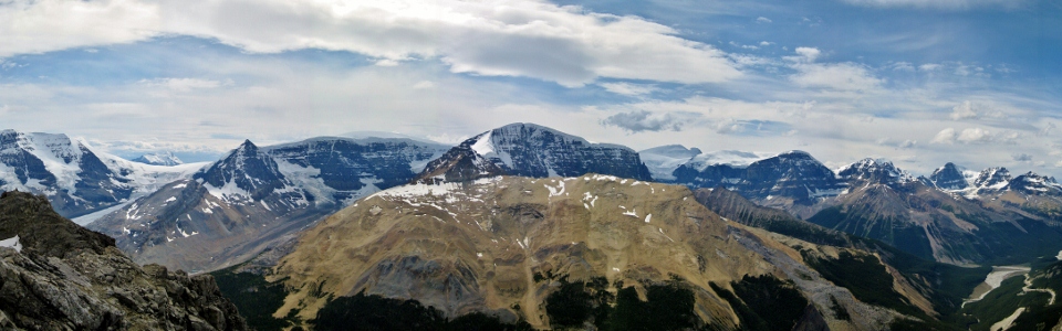
The ultimate icefields panorama. Click to see larger.
.jpg)
Goats are always so happy to be in steep alpine terrain!
.jpg)
After taking in the panorama for almost an hour, we reluctantly decided to start making our way back down.
.jpg)
Time to make our way back down. Brianne negotiating the exposed bit.
.jpg)
Classic descent technique.
.jpg)
The great views persist the whole way down the ridge!
.jpg)
Taking advantage of a scree chute to lose elevation and get back to Wilcox Pass as quickly as possible.
.jpg)
After a small break in the pass, the weather took a quick turn! I’m certainly glad that we summited when we did!
.jpg)
The one benefit of finishing off the day in unsettled weather: a rainbow!
.jpg)
Wilcox wildflowers.
.jpg)
Since we were planning another scramble the next day anyways, we decided to stay at the Rampart Creek hostel to save some driving.
.jpg)
That's a big beer! Oh well, she earned it! 2 day and 2 summits! Tomorrow, we go for the hat trick!
.jpg)