Paget Peak
Elevation: 2560 m
Elevation Gain: 1000 m
Paget Peak is an exception in the Canadian Rockies: a peak actually named after the first person to successfully climb it. In addition to being the first person to climb Paget Peak, Dean Paget was also a founding member of the Alpine Club of Canada. The peak's southern slopes previously served as one of the first fire lookouts in the Canadian Rockies. Although the structure that was used for this purpose remains there, it has not been used since the 1970s.
My Ascents:
August 13 2011, August 28 2010
Trailhead: Sherbrooke Lake Trailhead
Paget Peak is another one of my mom’s favorite scrambles (and my mom has good taste in peaks). The view is spectacular and the scrambling itself, fairly easy. The approach to the fire lookout is well-marked and easy and, from there, the scrambling is simple (you may need to use your hands for balance once or twice near the top). Like Mount Fairview and Cirque Peak, Paget Peak is an excellent objective for beginners. The terrain is non-technical and the views will keep them coming back for more! With this in mind, my parents asked me to join them and my uncle on Paget Peak for his indoctrination into the world of peak-bagging.
.jpg)
Uncle Peter makes his way skyward just above the fire lookout. Although the path crosses below the rock bands above to the right, the bands themselves are simple (and fun) enough to scramble directly up. Just be careful not to knock any rocks on the path below if you choose to amuse yourself in this manner!
.jpg)
A high alpine meadow just below the mound of summit scree provides a good last chance for a comfortable break.
.jpg)
4 wheel drive.
.jpg)
The summit of Paget Peak is located a 5 minute walk north from the first high point along the ridge and you must make your way past this brief down climb in order to get there. The down climb looks much worse than it actually is (and is, therefore, a good spot to collect epic-looking photos) despite what my mom will tell you.
.jpg)
I said the summit view was spectacular didn't I? Round-topped Mount Niles caps the valley above the lush green Niles Meadows to the north.
.jpg)
Mounts Niles, Balfour and Daly.
.jpg)
Beautiful Balfour!
.jpg)
The old man enjoys another summit in the sun.
.jpg)
The long red ridge of Mount Bosworth to the northeast.
.jpg)
Documenting my 30th summit of the summer.
.jpg)
The panorama to the north includes (from left to right): Mount Ogden, Mount Niles, Mount Balfour and Mount Bosworth. Click to see larger.
.jpg)
To the south, Temple just peeks out from behind Collier Peak. Mount Whyte and Pope's Peak to the left; Narao Peak to the right.
.jpg)
A stunning view of the Lake Louise group.
.jpg)
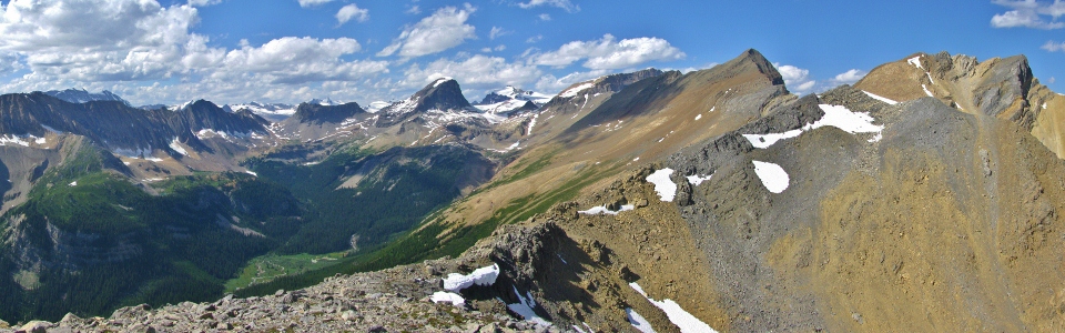
The incredible panorama to the south. From Lake Louise on the left to Field on the right. Click to see larger.
.jpg)
Mount Victoria dividing the continent.
.jpg)
Mount Biddle over Lake O'Hara. Wiwaxy Peaks in the foreground. Lake O'Hara is directly on the other side of Wiwaxy.
.jpg)
Success! Peter signing his first summit register!
.jpg)
Words of wisdom.
.jpg)
The Kickinghorse River winds its way past Field at the feet of Cathedral Mountain (left) and Mount Stephen (right).
.jpg)
Cathedral Mountain, complete with Cathedral Crags.
.jpg)
The imposing north face of Mount Stephen 2 vertical km above Field. The south face isn't really any less imposing either...
.jpg)
The Kickinghorse River.
.jpg)
Castle Mountain and the Bow Valley to the east.
.jpg)
My mom and Peter enjoying the last views from the summit before heading down.
.jpg)
Sherbrooke Lake in the valley below Mount Ogden.
.jpg)
What goes up must come down...classic 5-point descent technique. After this afternoon, she needed to buy new shorts!
.jpg)
Taking lessons.
.jpg)
Gord, on the other hand, made the descent look a little easier (if not a little more disturbing)!
.jpg)
.jpg)