After a 2.5-month hiatus from peak-bagging, I found myself with 12-days off-work at the end of 2024. With so much time off, a trip up a mountain seemed a near-certainty. Even Brianne agreed that I was overdue for a “Matt-day” (replete with summit-related suffering)! 🏔️ Then, on Christmas Eve, I hurt my back picking kids toys up off the floor (again). 😣 You’d think that I’d learn to embrace a filthy home in favor of sparing my spine by now but, alas, I’m not a quick learner… 🤷♂️ By the time my back felt up for a trip to the mountains, the weather and family commitments put the final nails in my 2024 scrambling season's coffin. ⚰️
Fortunately, the new year brought with it a new opportunity for a mountain suffer-fest. Having “banked” my end-of-2024 “Matt-day,” I reached out to the like-named Dr. Clay to see if he was also due for a “Matt-day.” Of course, he was (and always seems to be). After a flurry of instant messages, we settled on Zephyr Creek Hills because: they were relatively close; the weather looked too poor for something bigger; and they started with the letter “Z” (which my website’s “Summit” index had, heretofore, been missing)! 😝
While these hills didn’t sound especially impressive, Matt Clay had hiked them previously and he assured me that they still required “a big mountain effort.” I was sold, so at 7 am, we departed Calgary for, what would end up being, a test of will and good sense in the Zephyr Creek Hills.
.jpg)
Right from its earliest conception, our winter attempt on ZCHs probably defied “good sense” as the very first thing that one must do after parking at the (for some reason gated) Sentinel PRA is to ford the frigid Highwood River. Given the months of sub-zero temperatures that we’d endured, I figured that the river would be a mere trickle but discovered that it was more liquid and deeper than anticipated! Luckily, Matt C. had a spare pair of hip waders (with a “very minor leak”) to lend to me. After crossing, not one, but two, watercourses, we successfully reached the river’s southern bank with our boots relatively dry and our feet still warm (for now…).
.jpg)
The northwesternmost of the ZCHs (sometimes called North Limestone Ridge) makes an appearance at left as Matt C. completes his early morning ford of the Highwood River. With the knowledge that he’d previously hiked these hills, I didn’t spend much time researching our route ahead of time. If I had, I would have learned that there’s a reason that they’re “hillS” PLURAL. Indeed, Daffern’s Kananaskis Country Trail Guide highlights A DOZEN high points in them, connected by a web 🕸️ of on-trail and off-trail routes. For our part, Matt C. suggested that we follow the Zephyr Creek trail up the valley below North Limestone Ridge (essentially between the two bumps in this photo). At the valley’s end, we’d ascend Bear Pass and then hike up South Limestone Ridge before starting our ridgetop journey to the highest of the ZCHs. Confused, bewildered and ignorant, I simply followed him. 🤷♂️ I may not have been paying attention, but I’m pretty sure that he neglected to mention that Bear Pass was 9-km away!... 🤔
POST-SCRIPT: Had I done proper research ahead of time, I’d have learned that most scramblers directly ascend North Limestone Ridge at far left and forego the Zephyr Creek valley all-together. If I were to return, I’d probably do likewise but hindsight is 20/20…
.jpg)
This is, essentially, the view along Zephyr Creek for 9-km. Of the many “trails” in the ZCH area, Daffern correctly notes that “none are so wonderful you’d want to walk them for their own sakes.” 😂 Having come this way in the past, however, Matt C. had always found this trail well-packed by others. Unfortunately, that was not the case this year and we were forced to expend more energy than we’d hoped breaking trail through the viewless woods. 🥵 Travel was never difficult but, as the kilometers mounted, the word “tiresome” was thrown around with increasing frequency. Ironically, we’d settled on this front range objective to avoid snow… 🙄
.jpg)
For a while, we did have other tracks to follow: a wolf’s! But even the wolf 🐺 had the good sense to give up before reaching Bear Pass… 😂
.jpg)
As we continued up the LONG Zephyr Creek valley, the snow became deeper. In the woods, it was tiresome “sugar” and in open areas it was deeper sugar with a tiresome wind-crust to break through on top. It was not fun. To make matters worse, I started to note that my toes were getting VERY cold. The outside temperature was just below 0 C, but I’ve noticed that the circulation in my extremities isn’t what it used to be, and my toes and fingers freeze easily these days. 😞 Hoping to avoid this, I stopped to don iron-charcoal toe warmers.
.jpg)
With conditions in the Zephyr Creek valley challenging our will to continue live, we eventually spotted open slopes to the east and elected to side-hill along them towards Bear Pass (just out of sight above Matt C.’s head in this photo). By this point, we’d trudged just over 7-km up the snowy valley. Side-hilling is never fun, so the fact that our moods improved on this slope is a testament to how “tiresome” the snowy valley was! 😂
.jpg)
After about 1-km of mercifully dry side-hilling, we arrived just above Bear Pass. From here, we doubled back and continued up the grassy south ridge on our left. 3.5-hours after we’d left our car, we were finally ascending out of the Zephyr Creek valley! 🙏
.jpg)
At first the steep grass slopes along the south ridge provided straightforward access up. Nearer to the ridge crest, however, thickening forest slowed us considerably. The reason for this was twofold: 1) The thicket prevented wind from clearing the slope, so we were forced to trudge through snow (again) 😑; 2) The thicket was just that – THICK! Thanks to the prevalent west winds, errr, I mean zephyrs 🙃, in this area, these small trees had grown so twisted and strong that they were impenetrable in places! Normally, it takes very little effort to thrash through branches when trees are this size, but this slope was replete with zephyr-hardened super shrubberies!
.jpg)
Eventually, the slope’s steep angle relented and we reached a relatively level and open area near the ridgetop. Having been at it for nearly 4-hours, we decided to enjoy some lunch and a spot of tea ☕ amongst the pleasant terrain and good views here. As we did, I unfortunately came to the conclusion that the toe-warmers I’d donned earlier were not working. 😞 Indeed, a closer inspection of my feet revealed that the tips of my toes had turned blue. 🔵😬 Hoping to correct this, I changed into my spare pair of dry thermal socks and stuffed hand-warmers (which I knew were working) into them.
.jpg)
After teatime, we continued north along the ridge. As we ascended, the slabby terrain proved more entertaining than anything we’d passed earlier. With a renewed sense of positivity, we scrambled up, up, up.
.jpg)
Matt C. “enjoys” one of the ridge’s more knife-edged sections, bracing himself against the omnipresent wind, errr, I mean zephyr. 🌬️
.jpg)
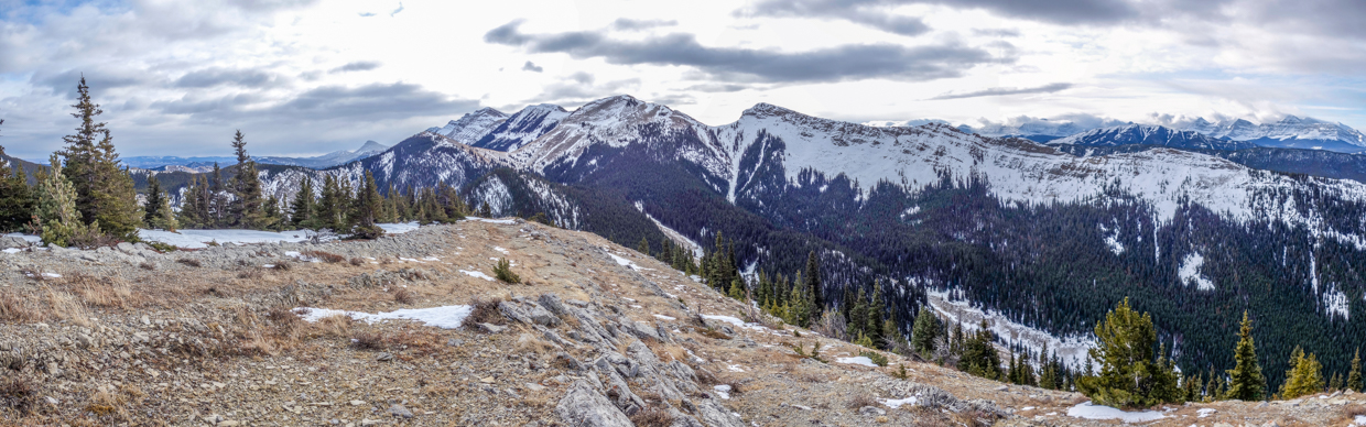
Panoramic views from the first high point along the ridge! Daffern refers to this ridge as South Limestone Ridge and it provided our first good views of the High Rock Range/continental divide to the west (only 4.5-hours after leaving the trailhead). Click to see larger.
.jpg)
Clouds cascade over Mounts O’Rourke (left) and Farquhar (right) to the southwest.
.jpg)
Looking west towards a quartet of near-3000-m-tall peaks (from left to right): Mount Etherington, Baril Peak, Mount Cornwell, and Mount Aldridge.
.jpg)
More cloud-capped High Rock Range peaks to the northwest (from left to right): Mount Armstrong, Mount Maclaren, Mount Strachan, and Mount McPhail.
.jpg)
To the north, the ridge extended towards Holy Cross Mountain (left) and the Bull Creek Hills (right). The popular trail up Grass Pass is visible at center and looked much less snowy than the damned Zephyr Creek valley below us! 🙄
.jpg)
To the east, we were finally able to see the highest of the ZCHs at far right and about 50 m higher than our current location. Obviously, we’d intended to tag this highest point (and we even started towards it briefly) but the intervening lee terrain, concomitant deep snow and my purple/blue toes gave us pause. Add to this, the fact that sunset was now only 4-hours away (and it had taken us 5-hours to get here) and good sense finally prevailed. We decided to turn around. We wouldn’t reach the highest of the ZCHs today, but we had, at least, tagged one of them!
.jpg)
The obligatory “summit” photo of a hiker who regrettably found himself up Zephyr Creek without a paddle. 🛶🤣 While turning around was the sensible thing to do, neither Matt C. nor I were looking forward to retracing our “tiresome” route back down the valley below me here… As noted earlier, Daffern calls this point “South Limestone Ridge” but I’m sticking with “Zephyr Creek Hills West” for the simple reason that I want a “Z” on my summit list (and I think I earned it)! 😝
.jpg)
As we started our LONG descent, the view east towards the highest of the ZCHs (left) and the Bear Creek valley opened up somewhat (it had been blocked by trees at the high point).
.jpg)
For better or worse, we managed to descend the slabby ridge without sliding off it to our doom, and soon found ourselves back on gentler, more tea-friendly terrain with panoramic views to the south. Click to see larger.
.jpg)
Distant Sentinel Peak (left) and more proximate Mount Burke rise up on the other side of Bear Pass.
.jpg)
A telephoto shot of Mount Burke reveals that an abandoned/dilapidated fire lookout still sits atop its summit.
.jpg)
.jpg)
LEFT: As we descended to Bear Pass, I experienced more hardship as my boot’s shoelace exploded 💥 leaving me without ankle support on the day’s steepest downhill. Fortunately, I carry spare laces (after a similar incident years ago) so I was, at least, able to tie my boot up again once we reached the pass and could sit down. It would seem that today was simply not my day!
RIGHT: Looking up towards a recent rockslide as we side-hilled back down to avoid the snow-choked Zephyr Creek valley for as long as possible. Sadly, the rocks had already fallen and they were, therefore, unable to put us out of our misery. 🙃
.jpg)
“Enjoying” dry hillside while it lasted (with 8 – 9 km of snowy valley between us and the trailhead). On the upside, the combination of makeshift toe-warmers and downhill-related friction had finally brought my toes back to life! 🥳
.jpg)
The ONE photo that I took over the final 8-km walk out. It’s pretty representative of the whole length of the valley (save for the smile on Matt C.’s face)! 😂 If this valley had been “tiresome” on the way in, it proved never-ending on the way out thanks to an achy back after too many miles travelling through the snow.
.jpg)
The day’s final indignity: having to ford a frigid river with cold toesies and a sore back. 😂 While we’d spent most of the day feeling like we were up Zephyr Creek without a paddle, we (at least) had hip waders for this part!
.jpg)
.jpg)