My wonderful wife Brianne and I both LOVE hiking with our kids. Nevertheless, I’ve started to also miss my special days atop a mountain with just her. Once upon a time, we were carefree and young and these adventure dates were a near-weekly occurrence. I never realized how spoiled I’d been to share so many unique bonding experiences and beautiful places with her. Recently, I was shocked to discover that 3 long years had passed since we last enjoyed a kid-free day in the mountains together! 🤯
After dodging a day alone with me for so long, I was, therefore, elated when Brianne finally committed to a kid-free mountain trip in celebration of our 11th wedding anniversary. 🤵👰💍 Not coincidentally, this aligned with my parents also committing to a full day of babysitting for all 3 of our young kids (after some artful dodging of their own).
Brianne and I got engaged and married in the Skoki area of Banff National Park, and we’ve also enjoyed a number of anniversary ascents there. We, therefore, decided to take advantage of our kid-free day to continue this tradition. Although Brianne initially said that she’d join me for “as big a trip” as I wanted, she visibly bristled when I suggested an outing that was over 50-km-long. Having presented her with the outrageous option first, she was much more receptive when I suggested 16-km-long Unity Peak as an alternative. 😂
Indeed, Unity had a bit of everything and, therefore, looked to be a perfect option for our long-awaited kid-free return to the mountains. From the option to bike part of the day, 🚴 to the beautiful larch valleys all around it, Unity had always been high on my (sub-20-km) to-do list. Unity even offered the potential for some interesting scrambling up high and a longer alternative descent via a different larch-filled valley. Of course, I kept these latter points to myself (for now). After more than a decade of marriage, I’ve learned that it’s best not to volunteer information that can turn your wife’s “yes” into a “no.” 😏 Instead, I satisfied myself with the knowledge that we’d finally get to enjoy a kid-free scramble together (regardless of the specific route that we chose on Unity). 💑
.jpg)
.jpg)
LEFT: Arriving at the busier-than-usual (*cough* larch season *cough*) Skoki trailhead, we made sure to bundle up as we readied our bikes. It was a beautiful morning to be sure, but a tad brisk (2 degrees C)! 🥶 Even the autumn chill couldn’t wipe the smile off our faces though. After 3 long years, neither of us had to carry our daughter Lillian up this mountain!!! 🎉
RIGHT: Brianne takes advantage of her bike to expedite a rare flat section on the Temple Fire Road (which is used to approach Unity Peak and pretty much every other mountain in the Skoki area). Even with a bike, however, this road is no joke thanks to the 350 vertical meters that it ascends (imagine biking up to the Calgary Tower’s observation deck about 1.8 times…). As a result of its generally steep grade, we ended up walking our bikes up ¾ of the road and it still took us a full hour to cover its 4-km distance. Pushing a bike up steep hills isn’t the most fun thing in the world but the payoff later in the day makes it SO worth it (imagine biking down from the Calgary Tower’s observation deck about 1.8 times)! 😁
.jpg)
.jpg)
LEFT: About halfway up the road, Brianne insisted that we stop to say “good morning” to some fellow backcountry adventurers (“Neighs!” as Lilly would say). 🐴
RIGHT: As she has in previous years, Brianne once again put me to work on many of the road’s steeper sections…
.jpg)
After an hour of mostly pushing our bikes up the road while hikers and backpackers incredulously passed us, we reached the bike drop and enjoyed a quick snack before stashing our bikes in the woods and continuing up the Skoki trail on foot.
.jpg)
.jpg)
LEFT: Only 0.7-km from the bike drop, we reached the unmarked turnoff for the Wolverine Valley, which is accessed using a faint spur trail that ascends to the climber’s right of a creek. 6-years earlier, we’d hiked up this same trail on a much snowier anniversary ascent of Wolverine Ridge. Fortunately, this year’s conditions were much better than those we’d endured on our last trip up here! 🙏
RIGHT: Following a short stint in the steeper forest, the trail soon delivered us up into a magnificent subalpine valley and we were treated to our first views of Unity Peak near the headwaters of this charming little creek. At first, a good trail followed alongside this creek but the path quickly disappeared as the surrounding meadows became increasingly boggy. Above this point, travel remained easy but we had to be careful not to step into any of the ankle-to-knee-deep water holes that were randomly distributed all about.
.jpg)
As we continued up the surprisingly moist valley, its evergreen forest was rapidly replaced by a spectacular proliferation of golden larch trees. THIS is my happy place. 😊 Better still, while hordes of others waited in long lines for shuttles to hike in nearby Larch Valley, Brianne and I had this equally colorful valley all to ourselves! Click to see larger.
.jpg)
As we hiked up the beautiful valley towards Unity Peak, the warm sunshine seemed to set the larch forest aglow.
.jpg)
Like all good things, our hike through the vibrant Wolverine Valley eventually came to an end and we found ourselves below Unity Peak’s mostly barren ascent slopes. Other scramblers have used vegetated patches to angle diagonally up towards the Redoubt-Unity col (center right) until a landmark pinnacle appears above and we did likewise. The grassy sections of this slope were mercilessly steep but otherwise unremarkable. The bouldery sections were extremely unpleasant, however, so we tried to pick a line that kept us off of these as much as possible.
.jpg)
About halfway up the steep slope, the pinnacle appeared above us (center left). From here, we continued to ascend using a rising diagonal line to reach the slopes below this rocky landmark.
.jpg)
.jpg)
LEFT: Brianne picking her way across some of the intervening rubble. This talus had the nasty habit of rolling away whenever we stepped on it. Concerned for the safety of our ankles, I decided that this was a good time to inform Brianne that there was a (much longer) alternative descent possible via the valley on the other side of the Redoubt-Unity col above us. Since Brianne was neither eager to go back down this hill nor eager to commit to a descent that would be about 8-km-longer, she suggested that we take a wait-and-see approach to this dilemma.
RIGHT: Safely across the blocky rubble, Brianne continued to work her way up steep grassy slopes. 🥵 Behind her, glacier-capped 11,000ers began to appear beyond Wolverine Ridge’s incredibly yellow slopes.
.jpg)
.jpg)
LEFT: Having reached the slopes immediately below the pinnacle, we continued straight up towards it. Others have reported that it’s possible to go up on either side of it and we elected to ascend to its left for the simple reason that we were sick of side-hilling and/or ascending diagonally. 😂
RIGHT: The gully to the left of the pinnacle wasn’t entirely pleasant but Brianne is used to spending her anniversary on terrain like this. Sometimes, I think she’d be sad if we celebrated on a stable slope. 😝
.jpg)
As we huffed and puffed up the nasty slope, we paused frequently to look at the ever-improving panorama that was unfolding behind us. Each and every time that we did, we remembered why we subject ourselves to this variety of high-quality suffering. Click to see larger.
.jpg)
Above the pinnacle, we found another rock band with intermittent breaks. Hoping to minimize unnecessary elevation gain, we side-hilled under this band towards the Redoubt-Unity col. The side-hilling wasn’t awful but, in retrospect, I’d just hike straight up to the broad ridge crest from the pinnacle and then over towards the col.
.jpg)
Turquoise Lake Louise finally came into view over Wolverine Ridge and its golden slopes as we reached the Redoubt-Unity col.
.jpg)
Brianne admires the view in her Lake Louise-colored hiking shirt. #Coordinated!
.jpg)
From the col, Unity Peak’s bouldery summit still looked far away but proved deceptively close (which is the opposite of how these things usually work out in the mountains)! 😂 Indeed, only 20 minutes after we reached the col, we found ourselves On Top of Unity Peak!
.jpg)
While the last bit to the summit went quickly, it wasn’t exactly a stroll in the park…
.jpg)
.jpg)
LEFT: Brianne carefully negotiates Unity Peak’s summit boulder field. Many of these rocks were appliance-sized (or larger) and they were inexplicably jumbled in an ultra-entropic manner with large gaps and chasms all about. Many times, we saw a boulder and wondered how on Earth it ended up in that position? At least once, Brianne tossed her pole so that she could use her hands and almost lost it down a bottomless black abyss between two large rocks. Fortunately, most of these massive boulders proved unexpectedly stable. In the end, this last bit of ascent wasn’t actually difficult but it did require care (and it worked best when you didn’t toss your pole in a hole)!
RIGHT: Brianne scrambles up a final, bouldery (of course) step. “Hon, where are your poles?” 🤔
.jpg)
My Love, ❤️ exactly where she likes it, On Top (of a summit boulder). 😉 There are actually a few boulders that are candidates for “true summit” on the jumbled mess that is Unity Peak but Brianne reasoned that the rock with the official Government plaque on it ought to be the “official” summit boulder.
.jpg)
.jpg)
LEFT: Said official Government plaque underneath Brianne.
RIGHT: While the plaque-adorned boulder provided a scenic perch, it did not provide a comfortable place to sit, so Brianne had to climb down off of it before she could enjoy her lunch. As you can see, she did this in the least graceful way possible and got herself “stuck” a couple of times before finally making it down onto a fatter, flatter rock. 🤣
.jpg)
While the boulder with the plaque may be the “official” summit, there was one messy pile of rocks nearby that was clearly higher. So, of course, I climbed it… This oven-sized boulder half-perched precariously atop a slightly smaller, down-sloping rock pillar was unequivocally the “true” summit (and after taking a photo of me atop it, Brianne suggested that I not linger there lest I tragically end up underneath it).
.jpg)
After “bouldering” about atop Unity Peak for a few minutes, we eventually decided to enjoy the summit’s rock pile’s lofty larch-filled views, which included this panorama towards the Protection Mountain massif and the Bow Valley to the southeast. Click to see larger.
.jpg)
To the east, double-summited Bonnet Peak (center) and Hickson Peak (center right) highlighted the view over a sea of mostly unnamed and remote peaks. While these peaks may be remote, they are not small. In fact, many of them are 3,000-m-tall or more.
.jpg)
A closer look at the Protection Mountain massif, which includes Bulwark Peak and Armor Peak, in addition to the massif’s namesake, highest peak.
.jpg)
Mount Avens (center left) and glaciated Pulsatilla Mountain (center) rise up to the east of Bulwark Peak’s spine-like summit (center right). Armor Peak’s summit is also visible at right and Helena Ridge can be seen filling in the impressive gap between Bulwark and the former.
.jpg)
Looking down the Bow Valley, a number of large larch forests lit up hillsides near and far with their awesome autumn ambers. 💛
.jpg)
Even though it was 71-km away, the highest peak in the southern Canadian Rockies, Mount Assiniboine, still made a dramatic appearance thanks to the crisp, clear fall air.
.jpg)
Glaciated Mount Ball (center) and Stanley Peak (center right) were similarly apparent 30-km to the south in Kootenay National Park.
.jpg)
🎵 Larches to the left of me, larches to the right; Here I am, stuck in the middle with views! 🎵 A magnificently colorful panorama south towards Purple Mound and the more distant giants of the Continental Divide. Click to see larger.
.jpg)
The famous “Ten Peaks” (left) and massive Mounts Temple (center right) and Hungabee (right) rise up beyond Purple Mound (center left) and Lipalian Mountain (center right).
.jpg)
A closer look towards the Valley of the Ten Peaks, which include (from left to right here): #1) Mount Fay, #2) Mount Little (hardly), #3) Mount Bowlen, #4) Tonsa Peak, #5) Mount Perren and pointy #6) Mount Allen.
.jpg)
The third highest peak in the southern Canadian Rockies (Mount Temple) towers between Lipalian Mountain (foreground) and the Peaks #7 (Mount Tuzo) and #8 (Deltaform Mountain). Peak #9 (Neptuak Mountain) is hidden behind Temple.
.jpg)
Peak #10) Wenkchemna Peak (far left) is actually just the shoulder of larger Hungabee Mountain. At center right, Mount Lefroy towers above Saddle Peak, Sheol Mountain, Haddo Peak and Mount Abderdeen. On the bottom right, a golden glow is apparent from larch-filled Saddle Pass.
.jpg)
The (now overcrowded) “jewel of the Canadian Rockies”: Lake Louise and her beautiful, blue water. That amazing color only happens because of the rock flour generated by the majestic glaciers on Mounts Lefroy (left) and Victoria (center).
.jpg)
Enjoying a kid-free summit with my Goat 🐐 for the first time in 3 years! ❤️
.jpg)
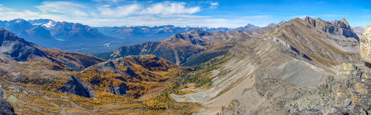
Looking west over a host of golden larch trees, the panorama stretched from Lake Louise (left) over Kickinghorse Pass (center left), up the Icefields Parkway (center right) and into the Skoki backcountry (right). Click to see larger.
.jpg)
Nearby Wolverine Ridge may be small but when it comes to fall colors, it is MIGHTY! Not to be outdone, Whitehorn’s ski hill-scarred northeast slopes also support an impressive larch forest. Last year, Brianne and I scrambled up Whitehorn and descended this larch-filled valley for our 10th wedding anniversary (with little Lillian along for the ride).
.jpg)
Glaciated peaks in Yoho National Park and along Banff National Park’s Icefields Parkway pierce the horizon beyond Wolverine and Whitehorn. From left to right, these include: the President, the Vice President, Mount Niles (ZAP), ⚡ Mount Daly, Mount Balfour, Mount Collie (distant), Mount Gordon, Mount Olive, Baker Peak (distant), and Vulture Peak.
.jpg)
To the northwest, 11,000er Mount Hector towers beyond diminutive Richardson Ridge, which like Unity has an unholy pile o’ boulders for a summit.
.jpg)
And last, but not least, the spectacular (you guessed it: larch-filled) panorama deeper into the Skoki backcountry to the north! Click to see larger.
.jpg)
Redoubt Mountain’s long afternoon shadow creeps towards the namesake Lake at its base. Beyond Redoubt Lake, tiny Packer’s Pass Peak and Skoki Mountain rise up ahead of much larger Cyclone Mountain (center left) and Pipestone Mountain (center right). The world-famous Skoki Lodge sits (unseen from here) at the base of Skoki Mountain.
.jpg)
An unbelievable expanse of golden larch trees carpet the valley to the northeast of Unity Peak. Across the valley, Heather Ridge rises up and a peak that is dear to us (Fossil Mountain) is the tallest one visible at center here. This is the valley that I suggested as an alternative descent route to save our ankles. When I pointed out the route to Brianne, she raised 2 reasonable “concerns”: 1) Going down this way would require that we walk all the way around Redoubt Mountain to get back to our bikes (and it’s not a small mountain). 2) She couldn’t help but notice that we’d actually have to walk uphill to escape this valley via Redoubt Lake. 🤔 Did I omit these details previously? Perhaps…
.jpg)
.jpg)
LEFT: Final larch-filled views towards massive Mounts Douglas (left) and St Bride (right) deep in the Skoki backcountry.
RIGHT: After an enjoyable half hour break atop Unity Peak, we came to the conclusion that this heap of boulders wasn’t going to descend itself and started back the way that we’d come. The easiest (alternative) way down is reached by initially descending south towards Purple Mound and then doubling back on Unity’s east ridge below the mass of boulders to and following it down into the valley. This meant that we’d have to go south, then east into the valley, then north to Redoubt Lake, then all the way around Redoubt Mountain to the south again. Perplexed? So were we, so we just went back the way we came! 😱😂 Speaking of going back, the pile o’ boulders which we ascended with relative ease seemed much more difficult in reverse! At a number of points, both Brianne and I made this jumble of rock look much harder than it actually was to descend!
.jpg)
Eventually, and with care, we escaped the summit blocks of doom and started the easy plod down towards the col with awesome views of Redoubt Mountain and Lake to keep us entertained. We briefly toyed with the idea of still descending into the alternative valley via the slope to Brianne’s right here, but closer inspection suggested that it would be at least as hard to descend as the one we’d climbed up earlier. Rather than double our fun suffering, we, therefore, decided to simply go back from whence we came (into the valley to Brianne’s left). Instead of side-hilling to the pinnacle, however, we hiked along the ridge crest ahead until we spotted the pinnacle below us and descended directly from there.
.jpg)
After a pleasant plod along the ridge, we spotted the pinnacle (to the right of Brianne’s head here) and started our scenic but STEEP descent into the Wolverine Valley – notice how the pile of boulders down there looks almost directly below?... 🤔
.jpg)
After carefully descending a mix of steep grass and rubble to the skier’s right of the pinnacle, we noticed a tempting grassy slope below it and to the left (farther up-valley than the one that we’d ascended). After moseying over that way, we were pleased to discover that this slope was indeed easier to descend! Better still, there was a tempting scree slope immediately to the left of it (further up-valley still). At first, it was obvious that this slope was actually hard dirt atop down sloping slab (!) but, about halfway down, it looked deep and steep. Since this is exactly the way that we like our scree, we moseyed left again and whooped and hollered as we ran, slid and plunge-stepped easily all the way down to the valley below. 😁
.jpg)
.jpg)
LEFT: At the bottom of our descent slope, Brianne looks back up towards the grass (left) and scree (right) which made our descent easy and fun. If I were to come back to Unity, I’d hike farther up the boggy valley to ascend this grassy slope directly to the pinnacle rather than side-hilling diagonally up and over to it.
RIGHT: After reaching the valley, we enjoyed one last snack break, soaking in the awesome autumn scenery and sunshine.
.jpg)
She’ll deny it but I think Brianne was actually happy to spend a day alone with me too… 💛
.jpg)
The best part of our anniversary scrambles is often the easy hike down a spectacular larch-filled valley at the end. Some might point out that we could just hike up these valleys and skip the nasty terrain above them but what fun would that be? Like our marriage, our anniversaries are usually an adventure. 😝
.jpg)
.jpg)
LEFT: Following Wolverine Creek back down the valley on a perfect fall afternoon.
RIGHT: In no time flat, the beautiful larch-filled valley became an evergreen forest with an easy trail to follow. This, in turn, led us back to the much easier Skoki trail which we followed to our waiting bicycles near the Temple Lodge. And this – THIS is where the real FUN began. From this point forward, we TORE down the Temple Fire Road like two love-crazed bats out of hell, reaching speeds of 42 km/hour. I don’t think that we needed to pedal once as we flew past some of the same hikers who’d looked at us like we were idiots when we were pushing our bikes up the same road earlier. “Later Dudes!”
.jpg)
After turning the 1-hour hike down the boring road into a 10-minute self-driven roller coaster ride, 🎢 our bikes delivered us back to the trailhead. Since the ride down had significantly expedited our descent, we made a pitstop for a pint along the banks of the beautiful Bow River in the Lake Louise Village. After all, Grandma and Grandpa were supposed to be babysitting all day and we didn’t want to arrive home too early and deprive them of that pleasure! 😏🍻
After 3 long years, it was an absolute pleasure to spend a kid-free day with my wonderful wife, celebrating our 11th anniversary with another shared, larch-filled adventure. 💛💛💛
.jpg)
.jpg)
.jpg)
.jpg)
.jpg)
.jpg)