Yearning for an escape from the city and its routine, Brianne and I decided to brave the Labor Day Long Weekend crowds for an overdue family hike on Sunday September 1st. August had come and gone (as it tends to) but the summer weather stuck around, so we concocted a half-baked, last-minute plan to enjoy the sunshine On Top of something; we just didn’t know what that something would be when we left the house… 🤷
“Fortunately,” hordes of other long weekenders cluttered up the highway so we had ample time to discuss options as we crawled along at playground zone-speeds. Brianne was eager to give the new trail up Ha Ling Peak a try, but I was weary that it would be ridiculously overcrowded, and that the scrambling might exceed the definition of reasonable for our youngest daughters.
With crystal clear blue skies overhead, I therefore proposed an alternative: the Tent Ridge Horseshoe. Tent Ridge is one of the most magnificent viewpoints in Kananaskis Country, and the Tent Ridge Horseshoe, which traverses the 4-km-long (you-guessed-it: horseshoe shaped) ridge 🧲 is a justifiably busy trail. It is also, if I am to be believed an easy hike with only occasional bits of “benign” scrambling. In short: a perfect outing for a young family like ours on a sunny, late summer Sunday!
While the traffic improved dramatically when we left Highway 1 behind, we still found the Tent Ridge trailhead jam-packed when we arrived (at the crack of noon) 😂, and were forced to park about half a km away at the end of a long line of other hikers’ cars on the roadside. Aw well, what’s half a km?... 🤷
.jpg)
.jpg)
LEFT: Just south of the main trailhead parking area, we easily located the starting point for those wishing to complete the horseshoe in a clockwise manner. Notably, this is not the same trail you’ll descend if you do the full horseshoe (the descent trail is a little north of the parking area). While Brianne and I clearly didn’t recall much from our previous horseshoeing, we knew it was easier to go clockwise since this allows you to ascend, but not descend, the ridge’s (supposedly) “benign” scrambly bits.
RIGHT: Having gotten off to a late start, Brianne was unimpressed when Penny found a host of wild strawberries alongside the trail. 🍓 These slowed us somewhat as our little hikers turned into little foragers. 😒 Eventually, we got them moving again by convincing them to leave some berries for the bears! 🐻
.jpg)
Like many outings in the Spray Lake/Smith-Dorrien area of Kananaskis, Tent Ridge involves an approach hike on a convoluted and overgrown network of old logging roads and cutlines. We followed the obvious one that we found just south of the parking area for about 600 meters (15 minutes with foraging children), and then reached our first junction. From here, the right (west) fork leads up Tent Ridge. The left fork has been strategically blockaded to make the correct trail obvious but the condition of the logs suggested that not everyone takes this hint. If you take the wrong turn here, you’ll eventually realize the error of your ways when you reach Tryst Lake…
.jpg)
.jpg)
LEFT: From the junction, staircase-like roots ascended through the woods. With the hot afternoon sun directly overhead, we were happy to enjoy some shade as we gained elevation here! In fact, the forest was cool and shady enough to support a significant mushroom population 🍄 to the delight of 8-year-old Mera who tirelessly pointed out each and every one of them.
RIGHT: Deadfall is another aspect of the Tent Ridge Horseshoe that I actually remembered accurately (ie: there’s a fair bit). While Mera enjoyed “limbo-ing” under these logs, Penny (apparently) takes after her Mom when it comes limbo form… 😂
.jpg)
Recently, we gave Mera her Mom’s old point-and-shoot camera so she could take pictures of our adventures. It’s always interesting to download them when we get home to see what made her personal highlight reel of the day... (photo courtesy Mera)
.jpg)
.jpg)
LEFT: About 2-km from the trailhead, we began to leave the forest behind as we entered the basin in the middle of the horseshoe-shaped ridge. On the left, the ridge’s rocky summit still looks far away, while the descent slopes on the right look discouragingly steep. Around this time, we were also startled by the rustling of something large in the woods. This happened to us at nearly the same spot in 2013 and, once again, we readied our bear sprays and made haste and noise as we continued up. As before, we were happy to never discover the true identity of the beast in the trees…
RIGHT: Brianne watches on while Penny crosses Monica Brook on a makeshift but substantial log bridge. Ironically, the brook’s water level was so low that it was easy to step over without risking a twisted ankle on this unstable timber (and I did just that).
.jpg)
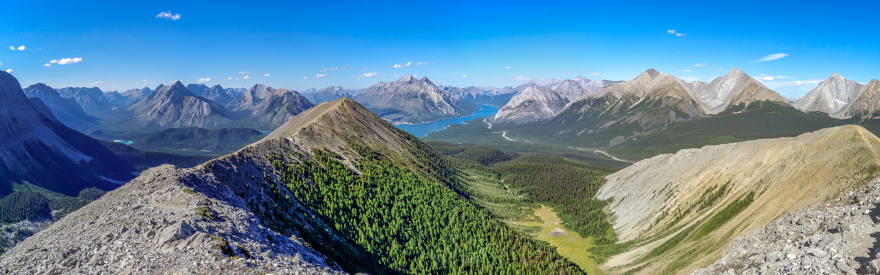
The full extent of the Tent Ridge Horseshoe, panoramically revealed from high up in the Monica Brook basin. From here, the route gains the rocky east ridge just out of sight to the left and then follows it up and over numerous “benign” scrambly bits before reaching the Space Command Center 👨🚀 summit (center left). From the SCCS, some elevation loss is necessary before ascending Tent Ridge’s true summit (center). The route then continues along the west ridge towards its northern summit before making its way down steep slopes on the right side of this panorama. Click to see larger.
.jpg)
.jpg)
LEFT: As we hiked up towards the east ridge, Penny (who just had her ears pierced for her birthday the day prior) proudly told Mera all about earrings and Mera’s imagination ran wild at the prospect of having her own one day soon. This proved so distracting that both girls forgot about the fact that I promised them a fun-size chocolate bar every kilometer on this hike and they scooted uphill, distracted and happy. Eventually, the pine forest gave way to larches and the girls continued up, now distracted by the trees’ silky soft needles. All of this, of course meant that there would be more chocolate for Mom and Dad! 🍫
RIGHT: Leaving the larches behind, Spray Lake made its first appearance as we started up the rocky ridge. Let the “benign” scrambling begin!
.jpg)
8-year-old Mera susses out the route as the terrain becomes increasingly rocky and steep. 🤔
.jpg)
Brianne keeps a close watch as 7-year-old Penny negotiates a scrambly step. For the record, it felt much less “benign” with 2 young children in tow and 1 on my back than it had 11-years earlier when Brianne and I last completed this route… 😬
.jpg)
My little route-finding pupil contemplates her next move.
.jpg)
.jpg)
LEFT: Hmmm. I guess I completely forgot about this steep step on the ridge… As we watched a pair of inconsiderate scramblers negotiate the steep terrain ahead, Brianne began to question my assurances that the scrambling on the Tent Ridge Horseshoe was limited and “benign.” In hindsight, the terrain wasn’t unduly dangerous, but it’s notable that I was too busy to take photos of my family while we carefully ascended this and other challenging sections…
RIGHT: For their parts, Mera and Penny LOVED the scrambling and arrived at the top of the steepest bit grinning ear-to-ear. 😁 Brianne also appeared to be smiling so it either wasn’t that bad, or she was thinking about the penance that she’d require of me after bringing our 3 young kids up here…
.jpg)
Above the steepest scramble, it was mostly an easy ridge walk to the first, Space Command Center-adorned, summit…
.jpg)
Mostly… 😂
.jpg)
After more scrambles than I recalled, we eventually reached the broad but scenic false summit to everyone’s great pleasure and/or relief!
.jpg)
.jpg)
LEFT: While the Space Command Center 👨🚀 atop this high point was an eyesore, it provided a welcome bit of shade where Mera, Penny, Lillian (and Brianne) collected the candy bar debt that I owed them for being such good hikers/scramblers on the way up. 🍫🍫🍫
RIGHT: Unfortunately, someone else was also interested in our candy bars. This aggressive little devil was stationed in the Space Command Center and, from the size of him, extracted a toll from each and every hiker that passed his post. While we tried to eat, he repeatedly attempted to get into our bags and earned himself a few “whacks” with our hiking poles-turned-squirrel-sticks… (Photo courtesy Mera)
.jpg)
The SCCS sported an impressive, peak-filled panorama south down the Smith-Dorrien Valley. Click to see larger.
.jpg)
A closer look at the British Military Group to the south (from left to right): CEGNFS, Mount Murray, Commonwealth Ridge (mid-ground), Mount Smith-Dorrien, Prairie Lookout, Mount French, Commonwealth Peak (mid-ground), 11,000er Mount Sir Douglas, “Pig’s Tail” (mid-ground), Mount Birdwood (mid-ground) and Snow Peak. Immediately below, tiny Tryst Lake adds a splash of color to the verdant valley.
.jpg)
The rest of the Tent Ridge Horseshoe filled much of the panorama north towards Spray Lake. Click to see larger.
.jpg)
Looking down over the Monica Brook basin about 90 minutes after we started our scramble up Tent Ridge to the SCCS. Peaks of note along the horizon include (from left to right): Beersheba Peak, Mount Turbulent, “Fortulent Peaks,” Goatview Peak, Mount Rundle (distant), Old Goat Mountain, Mount Nestor, the Three Sisters, Rimwall Summit and distant Grotto Mountain.
.jpg)
A host of old cut blocks adorn the foot of the Kananaskis Range to the east. From left to right: Mount Buller, Mount Engadine, the Tower, Mount Galatea, Mount Chester, Mount Inflexible and Kent Ridge North. Click to see larger.
.jpg)
After fending off the Space Command Squirrel 👨🚀🐿️ for 25-minutes, we decided to continue on our way, descending to the col between the SCC and the true summits of Tent Ridge. Compared to the scrambly ascent, the hike down to the col was simple hands-in-pocket walking that was complicated only by a preponderance of kamikaze grasshoppers. 🦗
.jpg)
23-month-old Lillian and her big sister Mera loving life with Dad at the col between the summits. From Lillian’s vantage, what’s not to like? As we met other hikers throughout the day, many pointed out her enviable position on either my back or Brianne’s!
.jpg)
Brianne and Penny demonstrate that what goes down, must go back up on the Tent Ridge Horseshoe…
.jpg)
.jpg)
LEFT: While the true summit hadn’t looked all that daunting from afar, its slopes seemed to get steeper and steeper the closer that we got to it…
RIGHT: … See what I mean? There may not have been any real “scrambling” of note on the mercilessly steep, summit push, but it definitely wasn’t benign! 🥵
.jpg)
Fortunately, the panorama and light breeze on the summit were ample reward for the steep grind and harder-than-expected scrambling required to reach it! Click to see larger. 😍
.jpg)
A proud Dad and his 4 favorite hiking partners On Top of Tent Ridge! 😁🥰
.jpg)
Thanks to clear skies, glacier-capped (and 60-km-distant) Mount Ball was visible up the Bryant Creek Valley. More proximate peaks visible here beyond Watridge Lake included (from left to right): Mount Turner, Mount Cautley, Gibraltar Rock, Cave Mountain, Og Mountain, Golden Mountain, Mount Mercer and Cone Mountain.
.jpg)
Compared to the SCCS, the true summit provided similar but slightly shifted views towards Spray Lake. It also showed how long the rest of our hike down the descent ridge (foreground left) would be… At least the scrambly bits were all behind us now, right?...
.jpg)
To the south and west, the Fist, Mount Birdwood, Mount Smuts and Mount Shark all presented formidable rock faces, darkened against a backlit sunny sky. Click to see larger.
.jpg)
Looking back towards the SCCS and tiny Tryst Lake at its base.
.jpg)
A closer look at the Fist (right) and its sheer cliffs to the south.
.jpg)
Things photographed by Mera: a heart-shaped snow patch ❤️ at the base of the Fist’s sheer north face. Looks like we may need to buy her a camera with a better zoom! (Photo courtest Mera)
.jpg)
To the south, a jagged ridge leads towards the Fist (out of sight on the left). The Fist, in turn, is connected to the Mount Smuts and the Mount Smuts is connected to the Mount Birdwood and the Mount Birdwood is connected to the Snow Peak (and so on and so on)! 🎵
.jpg)
.jpg)
LEFT: Inspired by a trio of non-stop Instagram posers that we shared the summit with, Miss Mera decided to that it’s never too early to get a jumpstart on her social media profile pics… 😂💪
RIGHT: Unfortunately, Brianne was not granted the luxury of posing (repeatedly) for the perfect pic as toddler-wrangling is full-time work when there’s a 300-meter drop-off beside you!
.jpg)
My “big girl” hikers proud to add another summit to their respective tallies. ❤️
.jpg)
After a hectic 😵💫 25-minutes trying to feed kids, take a few photos and keep Lillian from short-cutting down the mountain, we packed up and started the long walk north along the final section of the Tent Ridge Horseshoe. Since I’d carried Lillian all the way up from the meadowy basin below, Brianne volunteered to take a shift with the heavy toddler-bearing backpack after I reassured her that all the scrambling was now behind us. As I remembered it, the rest of the ridge was a simple, scenic hands-in-pocket walk!
.jpg)
Hands-in-pocket or not, we still needed to mind our step near the crest of the ridge!
.jpg)
.jpg)
LEFT and RIGHT: Okay, so if we’ve learned anything from this trip report, it’s that I am a liar and not to be believed when I say that something is an easy hike… 🤥🤷
.jpg)
Taking a break to single out and praise my “Penny Bear.” 🐻 This year, Mera has gotten a lot of attention for some of her big days in the mountains, but Penny did just as well (or better) than her big sister on Tent Ridge! With the exception of a stray grasshopper here and there, 🦗 this beautiful smile was plastered to Penny’s face all day long. Looks like Dad might have another little scrambling partner in training…
.jpg)
As we got further and further from the summit (center), the descent ridge eventually mellowed and made less of a liar of me. 😂
.jpg)
.jpg)
LEFT and RIGHT: Enjoying a long ridge walk with plenty of photo ops for my girls. 📷 Clearly, one of them was paying attention to the trio of ridiculous Instagrammers on the summit! I may have to show Mera “the Mermaid” on our next hike…
.jpg)
As we continued to work our way north along the ridge, massive Mount Assiniboine’s pyramidal peak (center left) made its first appearance of the day while its more proximate neighbors cast long shadows across the intervening mountainscape.
.jpg)
This is the ridge that doesn't ends, yes it goes on and on my friends…
.jpg)
Mera and Brianne begin to cast long shadows of their own… Hmmm, what time is it?...
.jpg)
About an hour after leaving the summit, we finally spied the end of this 2-km-long stretch of ridge. Excited at the prospect of losing some elevation before sunset, 🌅 we stopped for an end-of-ridge selfie while the scenery was still 💯 before finally starting our descent in earnest.
.jpg)
The northernmost high point of the Horseshoe offered the finest panorama towards Spray Lake yet! Visible peaks included (from left to right): Mount Mercer, Cone Mountain, Beersheba Peak, Mount Turbulent, Mount Fortune, Cascade Mountain (distant), Goatview Peak, Old Goat Mountain, Mount Nestor, Rimwall Summit, Mount Fable (distant), the Windtower, Lougheed I, Mount Lougheed, Mount Sparrowhawk and Mount Buller. Click to see larger.
.jpg)
Mera, Brianne and a napping Lilly 😴 start down the steeper-than-it-looks-here scree on the Horseshoe’s northern terminus.
.jpg)
.jpg)
LEFT: When the descent angle mellowed somewhat, we finally left the ridge for good and started down this trail, which side-hills its way back down towards the valley below. While the trail was obvious, and marked with a small cairn, we saw another oblivious party miss it all-together as they continued straight down the ridge.
RIGHT: Brianne provides Penny with a bit of assistance on a steep bit (or is it the other way around?)…
.jpg)
Continuing our scenic descent in the shadow of the ridge we’d just climbed.
.jpg)
After returning to tree line, we followed a good trail down “Gawby Gulch” which eventually delivered us back to one of the many old logging roads below.
.jpg)
.jpg)
LEFT: Everyone needs a little lift from their Mom now and then… After a lot of scrambling and ups and downs along the ridge, poor Miss Mera hit her wall about 1-km from the parking lot. 😔 Luckily she’s light and Brianne loves her!
RIGHT: As you can see, Mom wasn’t the only one shouldering a heavy load at this point. 🥵 Thank God Penny was able to keep hiking on her own 2 feet! 🙏
.jpg)
.jpg)
LEFT: Eventually, we all managed to get down to the parking lot... The only problem was that our car wasn’t in the lot since we’d been forced to park half a kilometer down the road. 🤦 My penance for saying that this would be an easy hike was, therefore, to retrieve our car, solo and in shame, while everyone else enjoyed a well-earned break.
RIGHT: As the sun set, Lillian enjoyed a pack of Reese’s Pieces for dinner after getting into her PJs (while Dad was still walking back to the car). #ParentsOfTheYear 🏆
.jpg)
Mera and Penny proudly show off the remains of, what had once been, a full bag of candy bars. Looks like my girls were busy while I was off retrieving the car! 🍫🍫🍫 Oh well, after 7.5-hours of “benign” scrambling, I’d say they earned it and we all learned a valuable lesson: don’t believe everything that you read on the internet (even if it’s on your own website)! 🤣
.jpg)
.jpg)
.jpg)
.jpg)
.jpg)
.jpg)
.jpg)