Mustang Hills
Elevation: 1844 m
Elevation Gain: 230 m (cumulative)
The Mustang Hills (also known as the Rainy Creek Hills) are a group of three high points located between Rainy Summit (the highest point of Highway 66) and the Elbow River. The Hills take their unofficial name from a herd of wild horses that frequent this area. Alberta is, surprisingly, home to over 1,000 wild horses, many of whom have been roaming free for several generations. Indeed, the earliest documented wild horse encounter took place in 1805 so it’s possible that some of these horses have been wild for hundreds of years.
My Ascents:
August 3 2024
Trailhead: Rainy Summit Roadside Pullout
GPS Track: Mustang Hills
With my 40th lap around the sun ☀️ set to come to an end, I let Brianne know that I only wanted 2 things for my birthday 🥳:
1) A day in the mountains with my family. 🏔️👨👩👧👧👶
2) A day in the mountains without my family. 🏔️🙌
Having enjoyed a solo bike and bog slog on Commonwealth Peak the day before my birthday, I was looking forward to a main event family hike on August 3. The only problem is, I was kinda tired 🥱 from the previous day’s exertion. 😂 Consequently, I suggested a teeny-tiny lil’ hike for the “main event” (and no one in my family seemed to mind)! 🤣
When it comes to itsy bitsy outings, Mustang Hills is one that I’ve kept in mind for a few years now. It’s not big, not bad, but a “summit” at least and it’s also conveniently situated. Apart from these factors, any mustangs 🐎 encountered would simply be considered a birthday bonus so after a bit of a lazy morning, we packed up the kiddos and ventured west towards hills, haze and (maybe) horses!
.jpg)
After a short 45-minute drive, we reached the roadside pullout at “Rainy Summit.” Rainy Summit is the high point of Highway 66 and also serves as the trailhead for Mustang Hills (which meant that the car got to do most of the work on this one thanks to the 230 vertical meters that the highway ascends). 😏 It seems I’m starting to work smarter not harder in my old age…
.jpg)
After an unnecessarily mad dash to cross to the east side of the highway, we started our search for the Mustang Hills trail amongst the area’s ample cow paddies and attack-grasshoppers. The hills in question are the forested bumps visible above my girls.
.jpg)
.jpg)
LEFT: Without much effort, we soon found and followed a good trail on the east side of the highway (just north of the roadside pullout).
RIGHT: Based on the amount of horse poop 🐎💩 that we ran into, it immediately became apparent that there are, indeed, mustangs in these hills (and presumably pooping mares as well).
.jpg)
After following the path for a few minutes, we found an old road and continued right (east) along it.
.jpg)
Not long after finding the road, we reached the beginning of an old cut block and followed a good trail up along its left side (center of the image above).
.jpg)
.jpg)
LEFT and RIGHT: The sparse trees on the cut block’s edge were home to all manner of colorful wildflowers including golden gaillardia 🌻 and pink paintbrushes. 🌷
.jpg)
It was extremely courteous of bygone loggers to clear the trees here so that I could enjoy this birthday view many years later!
.jpg)
6-year-old Penny, 1-year-old Lillian (aboard the ageless Breezy Goat 🐐) and 8-year-old Mera tackle the most "rugged" terrain near the top of the first (and highest) of the three Mustang Hills.
.jpg)
Penny and Mera pose with Dad for a birthday “summit” selfie. Because the highest hill is (still) heavily forested, 🌲 it offers no view so most (including us) continue on towards a pair of slightly lower, but more open, hills to the east.
.jpg)
The good trail that continues east of the first hill offered little in the way of challenge for anyone with legs longer than 30-cm. Weiner dogs: consider yourselves warned! 😂
.jpg)
Charting a path through more open terrain as we near the high point of the center hill.
.jpg)
A fire pit and crude log bench marked the high point and provided a good spot for us to enjoy a snack and a seat.
.jpg)
Those “lucky” enough to be on the ultra-exclusive invite list for Matt’s 2024 birthday bash. 🎉
.jpg)
A chip off the old (summit) block. A few weeks ago, we dug out an old “point and shoot” camera for Mera to play with. Now, not only does she enjoy scrambling up bigger mountains, but she insists on taking photo after photo after photo atop them. Sounds like someone I might know…
.jpg)
A day with the family in the mountains = the best birthday gift of all. 🎁😊
.jpg)
.jpg)
LEFT: After enjoying our lunch and the cozy log loungers on the central summit, we decided to continue on to the third and final Mustang Hill by following this trail down and into the woods near the fire pit.
RIGHT: The center Mustang Hill is, apparently, a double high point as we found this cairn so short a distance away that we knew we were still on the central hill not the eastern one.
.jpg)
From the cairned high point, the eastern hill came into view a short distance away. More distant still, Swany Ridge and Quirk Ridge (a pair of glorified foothills) were also apparent.
.jpg)
Mera leads us towards the “summit” of the third and final Mustang Hill…
.jpg)
… and Brianne, Lillian and Penny follow. The other part of my birthday present from Brianne was her agreeing to carry Lilly on this hot and humid August afternoon! 😁🥵
.jpg)
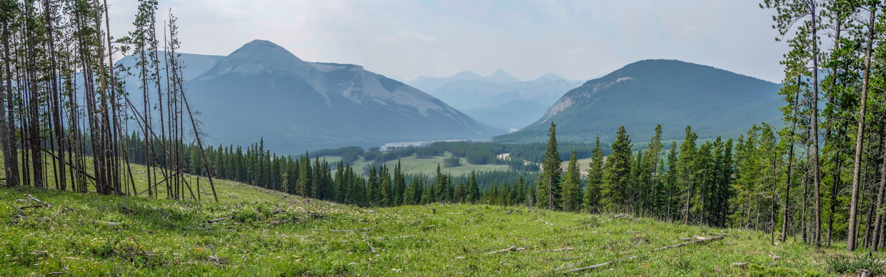
Even in the summer haze, the easternmost Mustang Hill provided a pleasant panorama west towards the larger front range peaks that rise above the Elbow River. Click to see larger.
.jpg)
A closer look at Old Forgetmenot and Forgetmenot Ridge above the Elbow River’s flood plain.
.jpg)
A quartet of much larger (1100 m-higher) mountains rise up through the Elbow River Gap to the southwest. From left to right: Banded Peak, Outlaw Peak, Mount Cornwall and Mount Glasgow.
.jpg)
The broad, treed flank of Powderface Ridge dominates the view immediately to the west of the Mustang Hills.
.jpg)
.jpg)
LEFT and RIGHT: Little Lillian 🥰 enjoys some freedom with (and without) her sisters on the sunny “summit.”
.jpg)
My happy little hikers start their return trip together. Not pictured is Brianne who was also happy to not have Lilly on her back for a little bit! 🙃
.jpg)
Penny and Mera lead us back up and over the center summit on our hike back. There’s no single significant elevation gain on this hike, but the repeated ups and downs throughout eventually provided us with the sense of having gotten some exercise at least!
.jpg)
.jpg)
LEFT: Brianne was happy to lead Lilly back through the woods (for as long as she was willing to walk for)!
RIGHT: Time’s up Mom! 😝 Eventually, Lilly got her way and Brianne’s load increased commensurately. Fortunately, the hike up and over all three Mustang Hills was relatively short (2.6-km each way), so it wasn’t long before we were back at the car and Brianne got to take a load/Lilly off. While some complete this hike as a circuit, we decided to simply follow the good trail that we’d found in an “out and back” manner (instead of exploring the alternative descent from the center hill, which is reportedly bushy). Our return hike was, sadly, Mustang-less but the persistent prevalence of poop 💩 suggested that it would only be a matter of time before you spotted wild horses in this area!
.jpg)
The epilogue to our “Happy Birthday Matt” hike: a nightcap on the patio at Cold Garden (thanks to a last-minute birthday babysitting offer from my parents)! 🙏 We may not have found horses, but the combination of hills, haze and a hazy IPA proved equally awesome. 🍻😄
.jpg)