After a spectacular autumn anniversary adventure with my wife the weekend prior, I found myself unable to stop thinking about a return trip to the mountains. Instead of sating my appetite for a scramble, the previous weekend’s ascent of Unity Peak seemed to whet it instead. 🤷♂️ With snow ❄️ already falling at elevation, however, I knew that the 2024 scrambling season was near its end so, I cross-referenced my calendar and the weather forecast hoping to find a suitable day for one “last” escape this season. When I did, I came to the surprising conclusion that the very next day was my last best hope for a scramble. 😱
Imagine Brianne’s surprise when I broached this topic at dinner time… “Love, can you please pass the potatoes (and, by the way, I’d like to climb a mountain tomorrow.)” 😂 While she was a bit taken aback by my very last-minute request, her only real issue with it was that I had no climbing partner lined up. You see, she doesn’t love me venturing solo into bear territory 🐻 at a time of year when they’re trying their best to fatten up! Unfortunately, I was unable to overcome this limitation on such short notice, so I tried to convince her that I’d pick a bear-free mountain (or at least one where the risk of an encounter could be minimized)…
Enter Mount Howard Douglas. Although the peak is just outside of the Sunshine resort’s lease, the entire approach to it follows roads and ski runs. While bears still frequent these, they're at least easy to spot (and maybe avoid 🤷♂️) when they’re on them! Better still, Howard Douglas is a big mountain, surrounded by larch forests so the idea of climbing it excited me. After promising my wife I’d make plenty of noise and keep my bear spray handy, I made my way to beautiful Banff National Park to cap my 2024 scrambling season with a second peak in a week!
.jpg)
Having discovered some years earlier that bikes are (surprisingly) allowed on the Sunshine access road/ski-out, I decided that Howard Douglas would also be my second bike-and-hike in a week. 🚴 As with last week’s outing, the day got off to a chilly start (2 degrees C and WINDY) but the combination of a steep road and a heavy mountain bike soon had me plenty warm! 🥵
.jpg)
The signage on the access road spoke the truth – this road is best described by a single word: UPHILL. While I struggled up (both riding and pushing my bike), numerous cars effortlessly passed me, whisking workers and contractors up to and down from the ski hill above. At one point, a van pulled over and the driver told me that he’d driven this road multiple times a day all summer and I was the first biker he’d seen attempting it.
.jpg)
.jpg)
LEFT: More wisdom from signs! As I huffed and puffed my way up the steep road, I definitely had to stop 🛑 (multiple times). 😂
RIGHT: Nearby Mount Bourgeau provided a scenic backdrop for at least one of those stops.
.jpg)
After 50 minutes, I reached the end of the line for my bike: the Goat’s Eye gondola station, 3.6-km from the parking lot and 380 meters above it. After locking my bike to a tree, I did some quick carb-loading (yum – granola bar!) and started off 100% on foot. 🚶♂️ While others on the internet have approached Howard Douglas using the “Sunshine Coast” run on Goat’s Eye, I decided to follow Nugara’s guidebook instructions and hiked up a smaller “connector” ski run that parallels the drainage between Eagle (Goat’s Eye) Mountain and the objective. The benefit to this approach was that it completely eliminated the bushwhacking and elevation gain/loss that are required to connect “Sunshine Coast” and Howard Douglas’ scramble route.
.jpg)
.jpg)
LEFT: From Nugara’s guidebook description, I’d been slightly concerned that it would be difficult to navigate the smaller “connector” ski runs but it was dead easy. There was really only one place where the ski run split (by this massive backlit boulder) and I followed the left fork here to stay as close to the drainage as possible. At one point, it was briefly tempting to hike directly up the drainage but Nugara doesn’t mention doing this so neither did I. A few minutes later, I was surprised to see that the gentle dry creek bed had become a small canyon full of dry waterfalls. I guess this is why you stay on the ski run! 🤷♂️
RIGHT: On my drive out, I’d noted that a decent amount of snow had fallen in the past week but I hadn’t expected to be hiking through it this low down! Nevertheless, I continued easily up the connector ski run as frozen heather crunched underfoot and golden larch trees began to highlight the otherwise evergreen forest.
.jpg)
Lovely larches proliferated as Mount Howard Douglas finally came into view.
.jpg)
About 2-km from the Goat’s Eye Gondola station, the connector ski run spat me out into a lovely little larch-filled cirque. The meadowy areas here provided the day’s first panoramic views which included Eagle Mountain (left), Mount Howard Douglas (center) and an impressive outlier of Howard Douglas (right). If you use the alternative “Sunshine Coast” approach, you’ll need to thrash down through the forest on the left at some point… 🌲🌲🌲 Click to see larger.
.jpg)
A final few larch trees aglow in the last sun that I’d see for a couple of hours.
.jpg)
As I hiked deeper into the cirque, I found myself surrounded by snow ❄️ and ice 🧊 and in perpetual shadow. Because of the massive cliffs to the south (climber’s right), there are many areas of this cirque that won’t see daylight from October until at least March. The majority of the route essentially follows the path of least resistance up the center and right side of the cirque, eventually angling left into the sunshine and up a steep scree slope that cleaves 2 very large rock walls. From the last of the larch trees, there is still about 600 vertical meters to go and Nugara is correct when he describes it as a slog of “biblical” proportions. Indeed, this cirque is the sort of thing that an angry Old Testament God might inflict on his enemies! 🦗🐸🦗🐸🦗
.jpg)
My God, what hath I done to anger thee?!
.jpg)
About a third of the way up the cirque, a small rock band broke up the steep scree. The waterfalls on the left of this band weren’t the only thing that was frozen here. In fact, the WHOLE slope was frozen SOLID. Typically, scree and talus have a predictable amount of give in them, allowing you to sink your boots in to gain some purchase. That was NOT the case in Howard Douglas’ cirque, where every rock, big and small, was frozen tight in place. This made the largely non-technical terrain quite challenging to ascend. With straightforward scree posing a challenge, I’d been concerned about this first rock band but was pleased to discover that it was pretty easy to break through it using a series of frozen ledges on the right.
.jpg)
.jpg)
LEFT: Above the first rock band, I began to angle to the climber’s left and up into the sun. I didn’t think it was possible, but the terrain actually got steeper the higher that I ascended! While it was nice to finally feel the sun’s warmth after about an hour and 400 vertical meters in the icy shadows, this steep slope remained quite frozen. In this regard, the ascent reminded me of the old “frog in a pot of boiling water” analogy. Steep frozen scree that I’d been concerned about lower down no longer seemed bad compared to the ridiculously steep frozen scree up here! Fortunately, small gullies filled with boot-deep wind slab made the ascent easier (provided that you didn’t slip). A pair of tracks down the snow also provided a measure of psychological comfort as it was clear that two scramblers had successfully navigated this terrain the day prior. Above the scree slope in this photo, the ledge traverse to the summit block is also visible rising slightly from left to right through the major cliff band above.
RIGHT: The frog (me) in his pot of increasingly warm water (the steep, frozen cirque). 🐸☕
.jpg)
After a long grind up frozen scree and snow, I finally reached the scree ledge traverse that cleaves the upper rock band. Not knowing how wide this scree ledge was, I was concerned that the traverse might not be feasible if it was snowy or icy but, apart from the first step to gain the ledge, it was mercifully dry! 🙏
.jpg)
Howard Douglas’ spectacular southwest outlier (and its now-perpetual shadow) highlight the panoramic views back down the icy cirque. To the left, the start of the scree ledge traverse is also visible. Click to see larger.
.jpg)
After gaining the scree ledge, I was pleased to find that it grew wider and wider as I followed it, with a razor-thin trail cut into its (still-steep) scree. The above photo shows one of the traverse’s easier sections but nothing was especially scary 😱 on the ledge.
.jpg)
At the far end of the ledge, a steep scree gully cleaved the massive rock band above, granting easy but unpleasant access to the summit ridge above.
.jpg)
From the summit ridge, the summit block finally came into view above the caves that Nugara notes (just visible as dark spots on the center left and center of this photo). Nugara mentions going to the right around difficulties on the ridge above, but I never had to detour more than a meter or two from its crest.
.jpg)
The final summit block under a brilliantly blue sky. The technical crux of the day lies just ahead with a moderate scramble step between the buttress at center and the one on the center right. While I had to “heave ho” myself awkwardly up this step, there was zero exposure so it wasn’t unnerving. The funny thing about Mount Howard Douglas was that its moderate scrambling steps weren’t frightening but its easy (STEEP) scree slopes were! MHD was, simultaneously the hardest easy scramble and the easiest moderate one! 😂🤷♂️
.jpg)
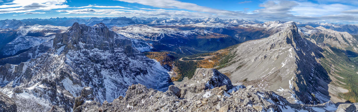
A heavenly reward for a slog of “biblical” proportions! ✝️ The panorama from the summit of Howard Douglas stretched from Mount Assiniboine Provincial Park (on the left), to Kootenay National Park (at distant center) and into Banff National Park (foreground and right). And no matter what Park you look over, there are colorful larch forests EVERYWHERE! Click to see larger.
.jpg)
A closer look at Howard Douglas’ dramatic, double-summitted southwest outlier and its long, cold shadow. Throughout the day, I was drawn to this beautiful peak (which didn’t look much lower than the true summit I stood atop). In fact, its dramatic ramparts reminded me of much larger Mount Andromeda as seen from the AA col scramble route up Mount Athabasca.
.jpg)
The outlier’s undulating ridge mirrors that of nearby Mount Shanks (center right in the sun).
.jpg)
Looking west over tiny Standish Hump towards the Monarch’s impressive ramparts. Just beyond the Monarch, the peaks of the Vermilion Range jut dramatically skyward (from left to right: Mount Wardle, White Tail SE1, Mount White Trail, Mount Verendyre and an unnamed outlier).
.jpg)
To the northwest, a series of colorful larch forests adorn the high elevation plateaus on Eagle Mountain, Wawa Ridge, Healy Pass and Harvey Pass.
.jpg)
Looking west over the heart of the Sunshine Village ski resort towards meadows that give way to the diminutive rock pile that is Twin Cairns (left) and the long Monarch Ramparts ridge (center to right). Above the Monarch Ramparts, Talc Peak (center), Numa Mountain (center right) and Scarab Peak (right) glow in the autumn sunshine while the larger peaks of the more distant Vermilion Range dwell in the cool shadows. With respect to the Vermilion peaks, the following are visible (from left to right): Mount Verendyre (above Hawk Ridge North), unnamed, Floe Peak, pointy Foster Peak, Hewitt Peak and Tumbling Peak.
.jpg)
Massive Mount Ball highlights the view to the northwest. At far left, the Pharoah Peaks rise up over the Egypt Lakes area, while outliers of Storm Mountain highlight the view on the right.
.jpg)
Storm Mountain (center right) and its many unnamed outliers. Beyond Storm, the backsides of many of the “Ten Peaks” are visible.
.jpg)
Mount Temple broods in the clouds to the northwest over much smaller Mount Bell. To Temple’s left, Mounts Fay and Babel are visible in the sunshine while Mount Daly and its east glacier are shaded by more overcast skies to Temple’s right.
.jpg)
The sunnier panorama northeast over Eagle Mountain, and the Massive and Sundance Ranges. The town of Banff is nestled between peaks at the panorama’s midpoint. Click to see larger.
.jpg)
.jpg)
LEFT: Nearby Eagle Mountain’s east face rises dramatically above an unnamed valley. Eagle seems to get very little respect from scramblers online but I thought that it was a great option for a short day with spectacular views. Beyond Eagle, Mount Brett (left), Mount Bourgeau (center) and Massive Mountain (right) are also visible. Ironically, Massive Mountain is the least massive peak in the area!
RIGHT: Looking down the unnamed valley towards the Sunshine access road at Massive Mountain’s foot. If you squint, you can see a roadside pullout on this road. Later in the day, I was sure to stop at this pullout to get the reverse view of Mount Howard Douglas (since it isn’t visible from many other places)!
.jpg)
Lake Minnewanka makes an appearance beyond the unnamed northern high point of the Sundance Range. To the Lake’s left, Banff icon Cascade Mountain sports a dash of summit snow and pointy Mount Aylmer towers above nearly everything else in the area. To the right of the Lake, Mounts Inglismaldie and Girouard also sport a dusting of the white stuff.
.jpg)
Looking west over outlying peaks towards the 22-km-long Sundance Range. This photo shows about 15 km of the Range and every single high point shown is, somehow, unnamed! 🤯
.jpg)
Looking east over the Sundance Range’s dramatically uptilted strata towards the official (left) and true (right) summits of Mount Rundle.
.jpg)
Unofficially named “Sundance Peak” (center left) is the north end of the Range’s high point.
.jpg)
The distant Kananaskis Range appears to the southeast of a host of (still) unnamed Sundance peaks. On the left, the Three Sisters (Charity, Hope and Faith) are visible. At center, the Mount Lougheed massif highlights the view. Last (but not least), Mount Sparrowhawk, Mount Bogart and Old Goat Mountain stand above all else on the right.
.jpg)
To the south, another scree cirque curves elegantly down towards remote Howard Douglas Creek and the day’s exclamation mark (Mount Assiniboine) ❗ punctuates the horizon at center. Click to see larger.
.jpg)
A wide-angle view south towards the heart of Assiniboine Provincial Park.
.jpg)
Fatigue Mountain rises up on the far side of Howard Douglas Creek. To Fatigue’s left, 11,000er Mount Sir Douglas is visible while taller-still Mount Assiniboine continues to steal the spotlight to its right.
.jpg)
The highest peak in the southern Canadian Rockies: Mount Assiniboine with a lofty plume of cloud extending from its 3618-m-tall summit. Far below, larch forests dot the alpine environs around Citadel Pass (one of the gateways into the core area of Mount Assiniboine Provincial Park). At right foreground, diminutive Citadel Peak stands watch over its namesake pass.
.jpg)
Larch meadows stretch from Citadel peak (center left midground) to Howard Douglas Lake (center right midground) with Simpson Ridge rising above and behind them.
.jpg)
The autumn sunshine sets snowy Quartz Hill alight to the southwest over the (on this day) aptly named Sunshine Meadows. On the hill’s far side, the Simpson River Valley winds its way though Kootenay. Some of the more significant peaks visible there are blocky Mount Daer at center, Mount Selkirk at center-right and Split Peak at right. Unofficially named “Needle Peak” also lives up to its billing between Selkirk and Split.
.jpg)
A very happy Matt on his second peak in a week! 😁 Sure beats the view from my office…
.jpg)
.jpg)
LEFT: After 30-photography-filled minutes on the summit, I started my descent in the hope of getting home in time to see my girls before their bedtime. Since the crux on Howard Douglas is this down climb immediately below the summit, I wasted little time finding my downhill legs!
RIGHT: Walking down the scenic and snowy summit ridge, still mesmerized by the view towards the impressive southwest outlier. 🤩
.jpg)
.jpg)
LEFT: Following a very short stint on the ridge, I returned to and descended the scree gully that leads back to the ledge traverse (just below the buttress on the right side of this photo).
RIGHT: Be sure to exit stage right to traverse back along the scree ledge! While it looks feasible to continue straight down the gully towards the cirque, there are some VERY BIG cliffs down that way! 😬
.jpg)
.jpg)
LEFT: Finishing up with the narrowest section of the scree ledge traverse. There is a small moderate step required to get back into the cirque from here. Rather than awkwardly scrambling down it, I simply hopped off of it ("What do you mean, jump?").
RIGHT: The part of the day I’d been dreading: my return to the frozen cirque… 😑 While I’d been worried about descending its steep terrain and frozen scree, I was able to make surprisingly good time by sticking to snowy gullies and patches wherever I could. Counterintuitively, the boot-deep snow provided better grip/purchase than the rock-hard dirt and scree below it! 😊🙏
.jpg)
As I wandered back through the cool shadow of the outlier, I continued to stick to snow wherever I could. This strategy made the descent much simpler and relatively quick! In fact, it was easy enough that I was able to actually enjoy the larch-filled views that unfolded at the base of the cirque and beyond!
.jpg)
.jpg)
LEFT: After carefully retracing my steps through a break in the cirque’s lower rock band, all that stood between me and more friendly terrain was a massive field of frozen boulders. These were neither pleasant nor awful and, with some care, my ankles and I escaped unscathed! 🥳
RIGHT: Off the frozen rocks at last, I returned to the ski area’s myriad signs. Again they spoke truth as I saw no patrols on Mount Howard Douglas!
.jpg)
Back on more hospitable terrain, I enjoyed a quick snack, surrounded by sunshine and golden larches, before following the connector ski run that I’d ascended down over still-frozen heather.
.jpg)
After 30-minutes of easy walking on relatively soft ground (!), I found myself back where my bike was locked up at the Goat’s Eye chairlift/gondola station. To my great disappointment, the BeaverTails kiosk was NOT open! 😭
.jpg)
While the lack of sugary fried dough was disheartening, I was fairly excited for the final stage of my descent: the roller coaster bike ride down the ski-out/access road. 🎢😁 What followed was a 7-minute white-knuckle extravaganza as my bike and I reached speeds up to 53 km/h on the twisty-turny dirt road! Like a successful saddle bronc rider, I somehow managed to stay on my steed and, before I knew it, found myself back at the car with my heart racing. THIS is why it’s worth it to push a bike up the 380-vertical-meter road if you’re hiking in this area!!! After stowing my “steed” and replacing my stiff mountaineering boots with comfy sandals, I hopped in the car, cranked the heat and started home to see my girls. ❤️
.jpg)
Oh, hello there. So much for Mount Howard Douglas being a “bear-free” mountain! 😮😂 About 1-km from the parking lot, I spotted this MASSIVE bear gorging himself on roadside berries (don’t show Brianne)! I was certainly glad not to have run into him while I was on foot or on my bike a few minutes earlier… Yo Bear! 🐻
.jpg)
After watching the roadside bear in awe for about 10-minutes, I resumed my drive home, stopping only to sneak a quick final peak of Mount Howard Douglas from the roadside pullout I’d noticed while I was on the summit.
Having stood atop one last big peak for the season, I continued home with a sense of satisfaction and even made it back in time to read bedtime stories with my little girls. As winter settles in around us, I’ll look forward to more downtime at home with them but, for now, I’ll continue to bask in the afterglow of another successful ascent and another memorable hiking season.
.jpg)
.jpg)
.jpg)
.jpg)
.jpg)