With my 40th lap around the sun ☀️ set to come to an end, I let Brianne know that I only wanted 2 things for my birthday 🥳:
1) A day in the mountains with my family. 🏔️👨👩👧👧👶
2) A day in the mountains without my family. 🏔️🙌
With a busy August long weekend planned, however, it looked like it would be difficult to sneak both of these in. I, therefore, submitted vacation requests to my boss and my wife (aka “The Boss”) for a mountain hall pass on Thursday August 1. Surprisingly, both of my “bosses” approved the time off and it looked like I was all set for a solo birthday scramble…
That is, until Lillian decided to spike her weekly fever the night prior. 🤒 Suddenly, my day off turned into a day cuddling a sick baby. Such is life. Plans change and you’ve got to roll with it. After taking my turn home with Lilly on Thursday, Brianne told me that she’d take her turn staying home with her on Friday so that I could still get out. After a last-minute, afterhours text to my other boss, I’d obtained all of the requisite approvals (again) was all set (again)! 🙌
Leaving Calgary at 5 am, I was excited. It had been a couple of months since I’d gotten out for an “adult-mountain” and I was looking forward to making the most of it. For years, I’d wanted to climb the highest peak in the Kananaskis Range (Mount Galatea) and today I was set to do just that…
.jpg)
That is, until I pulled into the trailhead parking lot and discovered that the required approach hike (Chester Lake) had been closed the day prior due to bear activity. 🐻🤦♂️ The funny thing is, I’d known that this was a possibility and looked into the status of the Chester Lake trail two days earlier (when it was still open). Such is life. Plans change and you’ve got to roll with it. After contemplating alternatives, I decided to attempt Commonwealth Peak because:
1) I suspected that its summit view would be magnificent (despite Kane’s claims that this peak “will never be an all-time classic”).
2) A mountain bike 🚲 can be used to expedite the day’s first and final 3.5-km (and I just so happened to have brought my bike to expedite my originally planned approach to Galatea).
3) The route up Commonwealth begins from the Burstall Pass trailhead, which was immediately across the road.
Pulling across the road, I quickly parked, readied my bike and my fancy new scrambling backpack (thanks Mom and Gord! 🙏) and set off on the first stage of my adventure: the bike ride!
.jpg)
The Burstall Pass parking lot may be the prettiest trailhead in the Rockies, especially on a quiet Friday morning when Mount Birdwood, Commonwealth Peak, Commonwealth Ridge and Tent Ridge are all reflected in the still waters of Mud Lake. Seriously, how often do I take panoramic photos a stone’s throw from the parking lot? Click to see larger.
.jpg)
After leaving the pretty parking lot behind, I quickly warmed up as I huffed and puffed and pedaled my two-wheeled steed up the old logging road that leads to Burstall Pass. The road was COVERED in bear scat 🐻💩 so the morning silence was frequently shattered by my “Yo Bear!” calls. After about 30-minutes and two dozen piles of poop, I reached the third Burstall Lake and decided to dismount so that I could follow a short spur trail that led to a better viewpoint. This viewpoint offered spectacular early morning views 😍 of the many peaks of the Birdwood group (from left to right: Snow Peak, Mount Birdwood, Pig’s Tail, Commonwealth Peak and Commonwealth Ridge). The peaks and their reflections made this short side trip a worthy one. After a few photos, I retraced my steps and returned to the main trail, where I resumed my bike ride up.
.jpg)
The end of the line for the bike! About 3.5-km from the trailhead, I reached the “No Bikes Beyond this Point” point 🚳 and locked my steed up. Instead of following the trail up towards Burstall Pass from here, I made my way on foot through the woods behind the bikes to begin the second stage of my birthday adventure: the bog!
.jpg)
The first of several streams that separated me from my objective. What looks like grass across this little stream is, in fact, a calf-deep, watery bog so my boots were removed at this point and tied around my neck for most of the next 0.6-km. As I waded across the bog, I was treated to great views of Mount Birdwood (left), Pig’s Tail (center left), Commonwealth Peak (center) and Commonwealth Ridge (right) and began to scout the route up Commonwealth, which ascends the avalanche gully on its left side to the still-shady Pig’s Tail – Commonwealth Peak col.
.jpg)
.jpg)
LEFT: As I marveled at the view of my objective across the bog, I occasionally stepped into a particularly “juicy” bit of bog and was quickly reminded that a scenic bog is still a gross one. 🤢
RIGHT: A more clever animal than I obviously managed to chart a drier course through this bog! 😂
.jpg)
A sun-kissed stream winds its way through the bog. Right above the steam, Mount Chester is silhouetted by the backlit morning sky. Somewhere below Chester, a grizzly bear with two cubs is enjoying having the approach to Mount Galatea all to herself.
.jpg)
.jpg)
LEFT: ♪ The bog necessities, the simple bog necessities… ♪
RIGHT: After finally putting my boots back on as I neared the far side of the bog, I discovered the deepest stream yet and was displeased that I’d have to “barefoot” it again. Sigh. Such is life. You’ve got to roll with it!
.jpg)
Across the stream, I was confronted with a brief, but unpleasant looking, bushwhack… 👀🤔
.jpg)
.jpg)
LEFT: After a short but scratchy thrash through the brush, I finally reached the open avalanche gully that runs all the way up to the Pig’s Tail – Commonwealth col above.
RIGHT: Commonwealth Peak above the flower-filled avi slopes. It was a good thing that these open slopes were pretty because I was about to spend the next 560-vertical-meters sweating my way up them! 🥵 And so began the day’s third stage: the endless avi slope…
.jpg)
With a forecast high in the low-to-mid-30 C range, this sunbaked avi slope was HOT. As I gained elevation, the views of the Robertson Glacier behind me continued to improve giving me plenty of excuses to stop for photos at least.
.jpg)
Up, up, I go, chasing Commonwealth Peak’s shadow in a futile attempt to get out of the hot sun. ☀️🥵 Sadly, the shade kept getting further and further away no matter how hard I hiked. Such is life. The Earth rotates. 🌎 Gotta roll with it...
.jpg)
Eventually, I found a boulder that was large enough to provide some shade and settled for this as a snack stop about two thirds of the way up the endless avi slope.
.jpg)
After my snack, I resumed my pursuit of Commonwealth’s shadow as I continued up to the col. As before, I was foiled by the rotation of my own planet.
.jpg)
After finally reaching the col, a persistent cornice blocked much of the view to the other side. While Kane advises against wandering onto this snowy feature, I found that its near side was a great place to lay down and “ice” my achy back for a moment or two… Mind you, had I done this any closer to the cornice’s far edge, a sore back would have been the least of my worries…
.jpg)
From the col, the remaining 250-vertical-meters of the ascent looked like it would prove more “entertaining” 🤔 than the long avi slope had been. Many of Commonwealth’s summit slopes looked impassable, however, the steep scree ramp that rises diagonally from the center of this photo towards the upper right provided access to a higher, hidden gully.
.jpg)
As I started up from the col, I left the cornice below and was finally able to enjoy the beautiful view to the north which featured (from left to right): Mount Assiniboine (distant), Mount Smuts, the Fist, Tent Ridge and Pig’s Back.
.jpg)
.jpg)
LEFT: Groveling my way up the blocky scree ramp… This was now officially the day’s fourth and final stage: the summit scramble!
RIGHT: Above the scree ramp, a nasty gully turned back to the climber’s left. Based on Kane’s recommendation and the substantial cairn, I turned left here as well and followed the gully up.
.jpg)
.jpg)
LEFT: Working my way up the hidden gully above the scree ramp. Down-sloping slab covered with marble-sized scree was the theme of the ascent here. 😣
RIGHT: At the top of the brutal gully (out of sight and below to the right in this photo), the final scramble to Commonwealth’s summit was revealed (and again marked by a substantial cairn). The route follows a chimney-like feature to the climber’s left of the high point in this photo.
.jpg)
.jpg)
LEFT: What the final 20-m scramble looks like once your nose is in it. While I’d been looking forward to a moderate scramble, this section felt a little more moderate than I’d have liked while I was on it! 😝 Ah well, what’s that I’m doing today? Right – rolling with it…
RIGHT: Rap slings at the top of the moderate scramble suggest that some folks find this section more challenging than others. 🤔 For my part, there were a few awkward lunges which may not have earned me any style points, but I’d generally agree with Kane’s moderate rating.
.jpg)
Hey, wait a minute! What’s the summit doing on the other side of that airy ridge? 😐 Kane says nothing of this ridge in his 2nd Edition (which I was using on this day), but his 3rd Edition (which I left at home) does note that the summit ridge is “fairly narrow” and that “evidently not everyone continues up this last bit.” Of course, I’d rolled with it this far, so I wasn’t going to let a short section of "fairly" narrow ridge stop me…
.jpg)
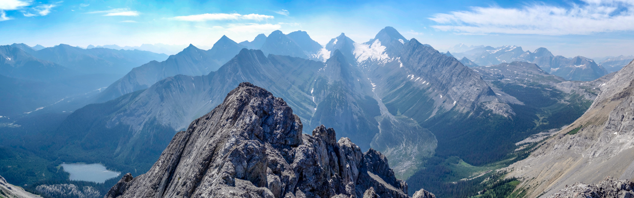
After a series of very careful steps, I finally reached the surprisingly small summit of Commonwealth Peak and was treated to a wonderful northward panorama that more than justified the misadventures that were required to get here. Click to see larger.
.jpg)
Mounts Eon, Aye and Assiniboine rise up beyond more proximate Smutwood Peak. The prominent peak in the middle ground is Mount Byng.
.jpg)
Mount Smuts’ sheer east face highlights the view to the north. Beyond Smuts, the peaks of the Sundance Range eventually give way to Spray Lake.
.jpg)
A closer look at the Fist (left) and Tent Ridge (center and right) above Spray Lake. Behind them and to the left, Cone Mountain and Mount Turbulent are apparent.
.jpg)
The Kananaskis Range fills the eastward panorama, which stretched from Spray Lake (left) to the Burstall Pass trailhead and Mud Lake (right). Peaks of note include (from left to right): Mount Nestor, Mount Buller, Mount Engadine, the Tower, Mount Galatea, Gusty Peak, the Fortress, Mount Chester, Headwall Peak, Mount Inflexible and Kent Ridge North. Click to see larger.
.jpg)
Looking down an extremely exposed crack towards Pig’s Back and tiny Commonwealth Lake. The photo here doesn’t entirely capture it, but staring down this chasm was vertigo-inducing! 😵💫
.jpg)
Spray Lake looks glassy-smooth between Mounts Nestor (left) and Buller (right). On Nestor’s left, distant Mount Rundle is visible, while the Big Sister appears to its right.
.jpg)
Who wouldn’t be smiling after an early morning bike ride, braving a bog, slogging up avi slopes and conquering a brutal gully full of scree-covered down-sloping slabs? That’s right, this is what I do for fun on my one day to myself! 😏🤷
.jpg)
A closer look across the Spray Valley towards the Rummel Lake Valley (left) and now-closed Chester Lake (right).
.jpg)
Looking back along the “fairly narrow” ridge, the point at the other end where I emerged from the scramble suddenly looked higher. While it wasn’t, it did sport a less obstructed view of the magnificent French and Robertson Glaciers, so I carefully retraced my steps to collect some photos from it before starting my descent in earnest.
.jpg)
Enjoying the less obstructed, glacier-filled southward panorama from the high point immediately above the rap slings/descent route. Click to see larger.
.jpg)
The Burstall Lakes (right) shimmer above Mud Lake (left) on a hot and hazy August afternoon. Later this evening, when I was back home with my family, a storm ignited a wildfire near these lakes, prompting the closure of the Burstall Pass trail the next day!
.jpg)
.jpg)
LEFT: Row up row of hazy silhouettes to the southeast: CGNEFS, Mount Murray, Mount Smith-Dorrien, Prairie Lookout and Mount French rise up beyond nearby Mount Burstall.
RIGHT: A closer look at the French (left) and Robertson (center) Glaciers across the valley to the south. Massive Mount Robertson separates these two icy expanses while 11,000er Mount Sir Douglas towers above them on the right. Below, a once-ice-filled valley is now filled with cascading streams.
.jpg)
A closer look at the rapidly retreating Robertson Glacier.
.jpg)
To the southwest, the rest of the trail to Burstall Pass is faintly visible below. Just above the Pass, Burstall Pass Peak rises gently before giving way to more significant peaks in the East Kootenays, including the Royal Group. Visible here (from left to right) are: Mount Princess Mary, Mount Prince Albert, 11,000er Mount King George, Mount Prince Edward, Mount Prince Henry, Mount Craddock, distant Mount Queen Mary, “tiny” Mount Tipperary, Mount Back, Mount Queen Elizabeth, Mount King Albert, Mount Leman and unofficially named “Royal Ridge.”
.jpg)
.jpg)
LEFT: And last, but not least, massive Mount Birdwood presents an imposing triangular face to the west. After taking in the views in all directions and enjoying a summit snack, 🥪 I started my descent down the summit block’s moderate scramble (visible in the shade immediately below me here). I’m a bit rusty, so I didn’t earn too many style points here, but I didn’t need the rap slings either at least! 😂
RIGHT: An ultra-scenic background distracts from the nasty gully ahead. It may look innocent enough in photos but descending loose marble-sized scree on steep down-sloping slabs is actually less fun than unexpectedly sinking into a dank and bug-filled bog!
.jpg)
.jpg)
LEFT: After surviving the gully, I traversed back out of it to the steep scree ramp that started this summit block scramble adventure and made my way back down to the tamer terrain at the corniced col below.
After cooling off with the cornice ❄️ for a moment, I started back down the massive avi slope towards the bog and glacial outwash flats some 600-vertical meters below. Presumably, a fault is responsible for the dramatic separation of gray blocky rocks and orange scree here. The latter proved lovely on the way down after my tense and tedious descent off the summit block! 😁
.jpg)
.jpg)
LEFT and RIGHT: Silky scorpion weed, pretty potentillas and all variety of other wildflowers 🌹🌻🌷 made for fine foregrounds as I descended with dramatic and distracting views of the Robertson Glacier throughout.
.jpg)
The avalanche gully stage of my adventure came to a scenic conclusion as I crossed the final few meters of deadfall and wildflowers.
.jpg)
Enter the bog! As I crossed the first stream channel and smiled for a selfie, I was surprised to discover that the water that had been knee-deep on my hike in was now thigh-deep or higher! Such is life immediately downstream of a glacier on a hot summer afternoon... Roll with it... While the water was painfully cold, it hurt in a good way given the extreme heat!
.jpg)
After an uneventful return through the bog, I reached my two-wheeled steed (back where I’d left it at the main Burstall Pass trail). From here, my descent was fast and exciting, as I sped down the fire road with my bike tires whipping up bear poo 🐻💩 as they reached speeds of 32 km/h! 😁
.jpg)
An excited scrambler 🤘 back at the scenic trailhead less than 15-minutes later. I don’t know how many times I’ve hiked up the Burstall Pass trail but this bike ride ruined it for me – I’ll never be able to walk it again!
All told, the exciting bike ride down provided a perfect cap to my 2024 birthday adventure: one that featured bogs, blocky rubble and a bit of scary scrambling for good measure. Better still, I finished around 2 pm, so I still got to enjoy an awesome evening with my girls before tomorrow’s “main event”: a day in the mountains with my family! ❤️
.jpg)
.jpg)
.jpg)
.jpg)