May 2024 will not be remembered for its mountain adventures as an unfortunate combination of work, work-related travel, and kids extracurricular activities conspired to keep us away from our beloved Rockies. 😔 When we finally had a commitment-free day on May 26, we therefore "pounced" 😺 on the opportunity to get out for an overdue Rocky Mountain adventure.
Unfortunately, those Rockies were still under a thick blanket of snow ❄️ thanks to this year’s unusually wet and cold spring. Looking for a snow-free adventure lower down in a valley, we therefore decided to visit Cat Creek Falls.😺 During summer months, a 3-km out-and-back interpretive hike provides easy access to these falls. Before June 15, however, getting to the falls is a bit more involved because of the annual Highway 40 closure which turns a simple hike into a more enticing bike-and-hike adventure. 🚴🚶
.jpg)
The greatest challenge of the day was not the hike or the bike - it was squeezing 3 bikes, 1 tag-along bike, a Chariot bike trailer and 5 humans into our modest SUV! Somehow, some way, I fit it all in! 🤯 After arriving at the highway closure gate, I then emptied our clown car-esque Highlander and reassembled various bikes and trailers to my wife’s, apparent, amusement.
.jpg)
.jpg)
LEFT: Right out of the gate, 8-Year-old Mera led the way on her first geared bike and wasted little time availing herself of those gears (since the road started straight up). Brianne, on the other hand, enjoyed a comparatively easy ascent thanks to 6-year-old Penny pedaling on the tag-along behind her (like a second engine at the back of a train). Or was the “lead engine” doing all the work on this hill? 🤔
RIGHT: 1-year-old Lillian and her tot trailer (most assuredly) did not provide me with any such “power-assist” on our way up hills. Even with pedals, this little one probably wouldn’t have been much help as she was overdue for a nap! 🥱
.jpg)
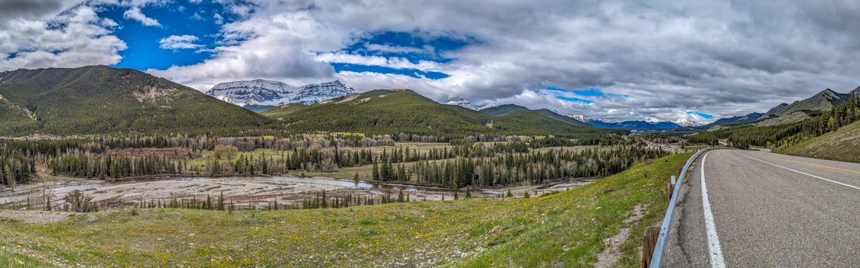
After starting our bike ride with a 2-km ascent, the highway crested “warmup hill”, 🥵 providing a pleasant panorama west and south over the Highwood River Valley. Click to see larger.
.jpg)
Snowy Mount Armstrong was the highlight of the view from the closed highway’s first hill.
.jpg)
Penny, Brianne and Mera feel the need for speed, cruising down the other side of “warmup hill!”
.jpg)
Apart from the first uphill, the highway grade rarely seemed steep so we were surprised that we couldn’t make it 5.5-km to the Cat Creek Falls trailhead before the kids needed to stop for a snack. On the bike ride back to the car, however, we realized that most of the ride in had been deceptively uphill…
.jpg)
After refueling, we enjoyed the last bit of our ride to the Cat Creek Provincial Recreation Area, where we were greeted by wintry views of Mount McPhail (left), Horned Mountain (center left) and Mount Bishop (center right) beyond the Hill of the Flowers (right).
.jpg)
.jpg)
LEFT: At the Cat Creek PRA, we easily located a trailhead sign for Cat Creek Falls and naively started our hike in the completely wrong direction. 🤦 I guess that’s the risk of trail signs that feature arrows in both directions… 🤨 Thanks Alberta Parks!
RIGHT: Starting along an obvious trail that was immediately behind the “Cat Creek Falls” trailhead sign. What could possibly go wrong, right? In retrospect, the small log that Penny is stepping over was probably meant to deter people from mistakenly following this trail like we did, but it wasn’t large enough to clue us in at the time… Especially since the trailhead sign was immediately in front of this path and had an arrow pointing in its direction!
.jpg)
Monkeys on a bench (on a trail that was not the one to Cat Creek Falls).
.jpg)
Hmmm… Where did the trail go? The lack of interpretive signs and on-again-off-again nature of the trail eventually started to clue us in that something was amiss… 🤔
.jpg)
The final clue that we were going the wrong way: this is the Highwood River. After following it for 1.5-km, it dawned on me 💡 that “Cat Creek Falls” would probably be along Cat Creek and not the Highwood River… 😐
.jpg)
.jpg)
LEFT and RIGHT: Most of the family was not pleased to hear this revelation, but Lillian didn’t mind turning around. Mind you, she wasn’t walking; she was getting carried!
.jpg)
After returning to our bikes, there was some debate as to whether or not we should even bother with the actual hike to Cat Creek Falls at this point. Eventually, we decided that we’d come all this way, so we might as well see the darned falls! To no one’s surprise, we found an obvious trail along the banks of Cat Creek. It should be noted that this trail was nowhere near the trailhead sign we'd discovered earlier and was actually on the other side of the highway from it! 🤬
.jpg)
.jpg)
LEFT and RIGHT: Interpretive signs were a good sign that we were actually on an interpretive trail this time!
.jpg)
After, for some reason, going up a steep hill and then back down the other side of it, the trail returned to Cat Creek where our kids were delighted to discover the first of two small bridges. Lillian seemed especially intent on tempting fate on these!
.jpg)
Mom watches while Lilly amuses herself by throwing stones into Cat Creek.
.jpg)
.jpg)
LEFT and RIGHT: AT LONG LAST!!! After 10-km of biking and hiking, we reached the end of the 1.5-km-long Cat Creek Falls interpretive trail and discovered that the falls were prettier than we’d been expecting. Not 10-km-hike-in-pretty, but pretty nonetheless! 🤣
.jpg)
Brianne and I enjoying a moment with little Lillian at the falls. We’d have taken a full family photo, but Mera and Penny (who claimed to be too tired to hike to the falls after our earlier misstep) were off climbing canyon walls and hopping across Cat Creek… 🙄
.jpg)
Aware that the hour was growing late thanks to our route-finding error and slowish bike ride in, we didn’t linger at the falls and made haste back to the closed highway so that we could start our long bike ride back before supper time.
.jpg)
My girls enjoy a deceptively downhill bike ride back to the highway closure gate. As mentioned earlier, the ride to Cat Creek hadn’t felt very uphill, but it took us only 1/3 of the time to get back, making it pretty obvious which direction gravity was on our side for!
.jpg)
Thanks to the largely-downhill bike ride back, Brianne and Penny were all smiles as they crested “warmup hill” for the second time and readied themselves for a speedy (44 km/h!) final couple of kilometers back to the car. 😁 There, I eventually managed to “Tetris” all of our bikes, trailers, and kids back in, bringing our Cat Creek Falls outing to a close. Click to see larger.
While the day didn’t go as planned (evidenced by our 16-km trip up a 3-km hike), adventures seldom do, and, with the benefit of hindsight, we eventually looked back fondly on this one! 😂
.jpg)
.jpg)