On September 14, 2013, Brianne and I exchanged vows, 👰🤵 in front of family and friends, high above Lake Louise on the sunny slopes of Whitehorn. ☀️ In the years since, we've made an anniversary tradition of either climbing a mountain together ⛰️ or having a baby together. 👶 The anniversary peaks currently outnumber the anniversary dchildren by a margin of 6 to 3. 😂
Anniversary Mountains:
• Eiffel Peak, the Onion, Wolverine Ridge, Lipalian Mountain, Purple Mound and Ptarmigan Peak.
Anniversary Babies:
• Mera, Penny and Lillian.
As our 10th wedding anniversary approached, we began to research potential celebrations. According to myweddinganniversary.com, “the added significance of your 10th wedding anniversary means that any celebration should be even more impressive than the nine preceding it.” Given that we weren’t expecting a 4th daughter in September 2023, this meant that we’d need to come up with a really good mountain to climb; some way of topping our other anniversary summits… 🤔
Always practical, I suggested an anniversary two’fer 😏 (two peaks in a single attempt not twins).
After the usual “why do I always have to hike on my anniversary” groans from Brianne, she surprisingly warmed up to this idea and we started planning our peaks in earnest. 🙌 Since a 10th anniversary, apparently, has “added significance,” it seemed appropriate to find a mountain that was equally significant to us. In this regard, Whitehorn was an obvious choice (having wed on its slopes ten years earlier and all… 😂). As I scanned Whitehorn’s surroundings, I noted that Richardson Ridge was nearby and that connecting the two would allow for a very scenic (gondola-assisted) loop. Excited for summits of significance, we pawned our eldest children off on our parents (thank you! 🙏) and made our way west towards the Lake Louise sightseeing gondola to celebrate our 10th wedding anniversary where we like it most: On Top!
.jpg)
.jpg)
LEFT and RIGHT: Usually, anniversary celebrations are for couples. On this anniversary, however, we were joined by the world’s cutest third wheel: nearly 1-year-old Lillian! 🥰 While Brianne and I have been on the Lake Louise sightseeing gondola a few times, this was Lilly’s first trip and, as you can see, she loved the speedy ride up Whitehorn’s lower slopes.
.jpg)
After gaining a cheeky 442 m of elevation, our first stop of the day was the Whitehorn deck, where we said “I do” exactly 10 years earlier. Getting to the deck required a 50 m elevation loss and a half kilometer walk out of our way but it was totally worth it to see Brianne roll her eyes 🙄 when I cued up the processional song that she walked down the aisle to on my phone. 😂 After waxing nostalgic for a few minutes (and sneaking an anniversary kiss 😘), I cued up our recessional and we returned to the top of the gondola to begin our hike in earnest.
.jpg)
.jpg)
LEFT and RIGHT: From the top of the gondola, we made our way through the resort’s ridiculous electric fence and started up the trail road towards the Kicking Horse viewpoint. Most visitors believe that this electric fence is intended to keep the bears 🐻 out of the gondola’s operations, but I’ve come to accept that its purpose is far more practical: to keep the tourists in… 🙃
.jpg)
In this regard, the fence is highly effective as we spotted only a handful of people hiking the short 0.65 km to the viewpoint. Above the viewpoint, we had the mountain to ourselves.
.jpg)
As we gained elevation on a ski hill access road, the surrounding forest transitioned from pine to golden larches and the views towards the glaciated giants of the Lake Louise group became more and more impressive.
.jpg)
Near the resort’s Kicking Horse viewpoint, we stayed on the access road as it turned abruptly to the east. As you can see from the look on Brianne’s face here, this moderately steep road had her openly questioning my assurances that the ascent to Whitehorn’s summit would be “easy.”
.jpg)
.jpg)
LEFT: Open ski runs full of frost-reddened fireweed provided a colorful fall foreground to compliment the mountain majesty that was unfolding across the valley.
RIGHT: About 1 km from the top of the gondola, the ski hill access road came to an end, and we continued up more directly on a smaller trail. This trail eventually led to another road (visible and rising diagonally to the east above Brianne’s head in this photo). We’d follow this road until it reached Whitehorn’s summit ridge and then turned back west and followed the “Summit” chairlift up the ridge.
.jpg)
The higher we went on Whitehorn, the more colorful larch trees we ran into. ‘Tis the season!
.jpg)
.jpg)
LEFT: Upon reaching the summit ridge, Lillian grew increasingly fussy (which is very unusual for her). Thinking that she might benefit from some free time, lunch and a diaper change, 💩 we therefore stopped short of the summit to give her a break. As you can see, most of that 25 minute break was spent trying to keep her from crawling off the mountainside. 😂
RIGHT: After our 25-minute baby break, it became apparent that our atypically fussy Lilly just needed a nap, so we packed her back up and set off anew for the summit, hoping that she’d fall asleep in her hiking backpack (like she usually does). 🤞
.jpg)
25-minutes later, we reached Whitehorn’s scenic summit with a still-awake, still-fussy baby. 😭 Fortunately, the summit featured a well-constructed windbreak, which became a high-altitude nursing room for Lilly and her Mom! 🍼
.jpg)
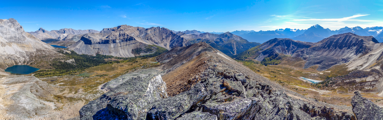
While Brianne nursed Lilly, I busied myself with the less-important task of photographing our panoramic 10th anniversary views over the Bow Valley. Click to see larger (and try to ignore the ski hill infrastructure and detritus).
.jpg)
To the east, amber larch forests added a splash of color to the slopes of Unity Peak (center left), Purple Mound (center) and Lipalian Mountain (right). Beyond this trio, Mount Avens, glaciated Pulsatilla Mountain, Bulwark Peak, Armor Peak and Protection Mountain were also apparent.
.jpg)
After Alberta’s smokiest summer ever, it was refreshing to see massive (but 75-km-distant) Mount Assiniboine again!
.jpg)
Across the broad Bow Valley, the view stretched from the Valley of the Ten Peaks (left) over to the Lake Louise group (right).
.jpg)
A closer look at the peaks above Moraine Lake and Paradise Valley. From left to right: Bident Mountain, Quadra Mountain, Mount Fay, Mount Babel, Mount Little, Mount Bowlen, Tonsa Peak, Mount Temple (!), Eiffel Peak, Neptuak Mountain and Wastach Mountain.
.jpg)
In his scrambling guidebook, Kane mentions that you must hike across the valley from Lake Louise to truly appreciate how beautiful this group of mountains is, and this view showcases that! Scenic peaks visible include (from left to right): Sheol Mountain, Hungabee Mountain, Haddo Peak, Mount Aberdeen, Fairview Mountain, Mount Lefroy, Mount Victoria, Collier Peak, Mount Whyte, Pope’s Peak, Mount St. Piran and Mount Niblock.
.jpg)
.jpg)
LEFT: After a good feed, both Brianne and Lilly were much happier and able to enjoy the views!
RIGHT: Little Lillian’s first summit views over forests filled with golden larch trees! 🥰
.jpg)
To the northwest, Whitehorn’s summit panorama stretched from Kicking Horse Pass, up the Icefields Parkway and into Skoki. Click to see larger.
.jpg)
A closer look at Kicking Horse Pass, which divides the provinces of Alberta and BC.
.jpg)
Broad-faced Mount Daly (center left) and glacier-covered Mount Balfour (center right) highlight the view up the Icefields Parkway.
.jpg)
11,000er Mount Hector and a host of other peaks to the northwest.
.jpg)
Merlin Ridge (center right) doesn’t look as grand as many of the surrounding peaks, but its ascent provided me with a great adventure earlier this year.
.jpg)
While Whitehorn’s frontside grants amazing views towards Lake Louise, its backside looks into Skoki and may be even more scenic. 😍 Click to see larger.
.jpg)
Mount Richardson was the first Skoki Peak that Brianne and I ever climbed together, and I intended to propose to her on its summit (but decided not to because it was overcast that day). 🤷
.jpg)
To the north, a blue tarn and golden meadows made the hanging valley between Whitehorn and our next anniversary objective, Richardson Ridge, enticingly colorful.
.jpg)
Looking over Richardson Ridge and deeper into Skoki. As always, Mount Douglas (center left) and Mount St. Bride (center right) were scenic highlights but, in terms of memories, the two peaks on the left of the photo take the cake. You see, Ptarmigan Peak provided Brianne and I with another anniversary adventure (and her 💯th different summit), while Fossil Mountain’s apex was the place that I actually proposed (on a sunny day 😏), and started our greatest adventure of all: marriage to one another!
.jpg)
Larch-filled hanging valleys below Richardson Ridge (left) and Redoubt Mountain (center) were my second favorite part of the view from Whitehorn on this day.
.jpg)
And the best part of the view was, of course, my beautiful wife Breezy Goat 🐐 and our baby girl.
.jpg)
After an enjoyable summit stay in the sunshine, Lillian grew fussy once more. You remember that nap that we hoped she’d have on the way up Whitehorn? Well now, she was really overdue! As anyone with a baby knows, getting them moving (in a car, stroller or on your back on a mountain) is the best way to soothe them to sleep, so we started down Whitehorn’s backside towards our next objective: Richardson Ridge (right). While the connecting ridge between these two features looked tempting on topographic maps, an intervening high point (above Brianne to her left) made it less so in person. To avoid this uncharted obstacle, we followed the drainage ahead of Brianne down and then side-hilled below the intervening prominence on its east side (right in this photo).
.jpg)
Magical autumn views into the tarn and larch-filled hanging valley between Whitehorn and Richardson Ridge. Even more magical still, Lillian fell asleep as we side-hilled between the two! 😴
.jpg)
Brianne, appropriately, follows a goat trail through the scree towards Richardson Ridge. Eventually, this trail became less of a hands-in-pocket walk as it descended more steeply towards the base of a prominent rock band that, from afar, looked like it might be problematic with a “baby on board.”
.jpg)
Nearing the potentially problematic rock band (left), we were treated to wondrous views east down the hanging valley behind the Lake Louise ski resort. Originally, our plan had been to ascend the south slopes of Richardson Ridge and to descend its north slopes towards Hidden Lake before hiking out on the main Skoki trail. Views like this, however, tempted us to descend via this valley (on Richardson’s south side) instead…
.jpg)
Up close, we easily located a hike-able break through the rock band that, from afar, looked like it might cause us some consternation.
.jpg)
Above the small rock band, we were treated to fine views of Mount Richardson beyond the Whitehorn-Richardson Ridge col. The sharp buttress on the left of this photo shows why a direct traverse along the ridge that connects these peaks is not feasible for scramblers with a baby.
.jpg)
Having descended nearly to the level of the hanging valley, we reached the base of a suddenly very steep-looking Richardson Ridge, which towered 280 vertical meters above. Since Whitehorn’s summit, we’d been dealing with a steady and cool breeze that constantly threatened to wake Lillian. We’d hoped that this wind would abate in the valley bottom but, perplexingly, it seemed even worse down here! 😔
.jpg)
.jpg)
LEFT: Lillian enjoys a restless nap in the wind, while I enjoy a good grunt up the Ridge’s very steep grass slopes. 🥵 It would have been nice to catch my breath a few times on this slope, but I was terrified to stop for fear that the sudden lack of motion and steady, cool wind would lead to Lillian waking up “on the wrong (proverbial) side of the backpack.”
RIGHT: Brianne follows Lilly and I up increasingly scenic slopes. Behind her, you can see the side-hilling descent line that we took to get here from Whitehorn (upper left).
.jpg)
Looking back towards the hanging valley and the ski resort’s back bowls. Sadly, these scenic slopes will see much more visitation abuse in the near future, thanks to a planned ski hill expansion up Richardson Ridge. Parks Canada may think that downhill skiing is a responsible use of natural lands, but the number of carelessly discarded beer cans and old snow fencing that we found while hiking on the ski hill’s lease 😒 definitely suggested otherwise…
.jpg)
As we neared the Ridge’s high point, we were treated to wonderful views of a previously unseen hanging valley. With a pair of binoculars, it would have been interesting to sit here and scan this more remote valley for wildlife but, since we forgot them, we just had to keep slogging up Richardson Ridge. 🤷😂 Around this time, the wind finally succeeded in waking Lillian as well, so we hurried on, under the impression that we might operating on borrowed time…
.jpg)
From afar, it looked like the Ridge’s summit might be a jumble of unstable boulders. As we neared the peak, we unfortunately confirmed this to be the case. There were definitely “moderate” scramble routes up from here, but the unstable nature of the terrain made it unwise to attempt these with a baby on my back. Hoping to circumvent the steepest of the boulders, we ventured southeast along their base and looked for an easier way up. In short order, we reached the grassy ridge crest but a quick look back towards the summit confirmed that there was no boulder-free way to the top.
.jpg)
.jpg)
LEFT: Having found the summit’s gentlest aspect (its southeast ridge), we started cautiously up the mess of boulders. After only a few steps, Brianne asked me to stop, as the terrain was no longer baby-friendly. I pressed on for a few more steps, hoping that it would get better, but it didn’t so I heeded her advice and we returned to the safety of the grassy ridge crest. Here, Brianne generously offered to stay with Lilly while I tackled the final 20-meter-high pile of boulders.
RIGHT: For her part, Lilly was perfectly happy to enjoy the near-identical views from much safer ground on the grassy ridge crest.
.jpg)
While the views from Whitehorn were wonderful, the panorama from Richardson Ridge was better-still, 😍 thanks in large part to the improved views of Skoki’s abundant alpine meadows, lakes and tarns. Click to see larger.
.jpg)
Not surprisingly, Richardson Ridge provided fine views of nearby Mount Richardson.
.jpg)
From the summit, the dark blue hues of Hidden Lake, Ptarmigan Lake and Baker Lake contrasted beautifully with the Skoki’s golden meadows and larch forests.
.jpg)
Magnificent hanging valleys to the left and right, plus views that showcase the best of Skoki and the Bow Valley. Add it all up and you get a 10th anniversary panorama that’s “even more impressive than the 9 preceding it.” 😁 Click to see larger.
.jpg)
Colorful tarns, lakes and larches line the valley floor between Richardson Ridge and Redoubt Mountain.
.jpg)
Crisp fall views southeast along the Ridge’s spine towards Banff, Assiniboine and Kootenay. Bonus points if you can spot Brianne and Lilly enjoying their ridge-top perch. 👀
.jpg)
Today’s trip report is brought to you by the term “hanging valleys” and the word “colorful.” Click to see larger.
.jpg)
.jpg)
LEFT: Massive Mount Temple towers above another pair of tarns on the backside of the Lake Louise ski resort.
RIGHT: Looking back to Whitehorn and beyond towards the always impressive peaks of the Lake Louise group.
.jpg)
A closer look at the ridge connecting Whitehorn to Richardson. Based on the number of side-hilling trails visible in the scree on the left, the goats in the area obviously know better than to attempt the direct route between these two points!
.jpg)
A final westward panorama stretching from 11,000er Temple to 11,000er Hector. Click to see larger.
.jpg)
Last looks northwest towards icefields and an 11,000er.
.jpg)
After hurriedly taking photos in all directions from Richardson Ridge’s heap-of-boulders summit, I quickly made my way back to my wife and daughter. Although it only took me 10 minutes to ascend, take photos and descend, the cool summit wind had Lillian less pleased with this anniversary peak than Brianne and I were. While I was away, Brianne worried that Lilly was cold and changed her into a fleecy sleeper. In the interest of finding a warmer place for a break, the decision was, therefore, made to pack up and descend ASAP.
.jpg)
Of course, we couldn’t go down without a ridge-top 10th anniversary selfie featuring my wonderful wife, yours truly and the cutest third wheel in the Canadian Rockies. ❤️
.jpg)
Having had her fill of the now-vexing wind, Brianne starts down the Ridge. Initially, we planned to walk along the crest until an easy descent line appeared to the skier’s right but we quickly tired of the wind and just went straight down. While we’d mused about descending left towards Hidden Lake, this route looked rockier and would have been a couple of kilometers longer, so we decided to explore the shorter but equally pretty valley between Richardson Ridge and Whitehorn instead!
.jpg)
.jpg)
LEFT and RIGHT: Brianne tackles steep scree and then grass on our descent line. At one point, the steep slope even tackled her back! 😬 Fortunately, Lilly was on my back and Brianne was fine. In the end, I suspect she’s not the first person to suffer a bruised behind on their 10th anniversary… 😉
.jpg)
After a steep 250-meter descent, we found ourselves on much easier terrain in the hanging valley below. While Brianne wanted to descend directly, I managed to steer us a little off her intended route so that we could visit the pretty tarn below.
.jpg)
An off-course but pretty panorama from the tarn’s edge. I was, however, warned not to wander further to see if it looked better from other angles. 😂 Click to see larger.
.jpg)
As we hiked down through idyllic terrain, alpine meadows gradually gave way to small stands of larch. It was around this point that the persistent wind also abated at last. 🙏
.jpg)
.jpg)
LEFT: Brianne follows the tarn’s outlet stream down into denser larch forest.
RIGHT: Looking back upstream as we prepared to leave the valley’s beautiful alpine environs behind. As we neared the tree line, we stopped for a proper, windless, lunch break 🥪 and let Lillian loose so that she could explore the more baby-friendly meadows.
.jpg)
After a relaxing respite in the afternoon sun, we reluctantly started back down. Following the stream, we began to notice litter and detritus, signaling that we were once again within the domain of careless skiers and careless ski hill operators. 🙄 Soon after, we stumbled upon a chairlift and its access road, which we followed easily down towards the Temple Lodge below.
.jpg)
From the Temple Lodge, all that was left was the “short” 4-km hike back down the horrifically hard-packed Temple fire road. Having walked this road far too many times (and often on her anniversary), Brianne didn’t hesitate to let me know what she thought of it! 👎
.jpg)
.jpg)
LEFT: Lilly was no fan of the Temple fire road either and Brianne worked hard during our hike down to keep her amused in her backpack perch. Here “Mom” demonstrates her “skills” twirling “batons”… It was a miracle that none of us lost an eye! 🤣🙈
RIGHT: After surviving the fire road descent without any tears (from baby and adults alike!), we let Lilly free at the Skoki/Fish Creek trailhead. Here, she decided that she preferred to wear the rest of her lunch instead of eating it, 🙄 and Brianne enjoyed a nice rest. What did I do, you ask? Those paying keen attention may note that we didn’t start the day at the Skoki/Fish Creek trailhead… This meant that someone still had to run back to the gondola parking lot and, you guessed it, that someone was me! Better still, thanks to the electric fences that the ski hill uses to keep the tourists in, I couldn’t go back directly and had to run down one road and then up another for about 3-km to get back to our car. While this wasn’t the most pleasant way to finish our hike, it was not nearly as “impossible” as the girl at the gondola ticket kiosk thought when I asked about electric fence locations earlier in the day. 😉😏
.jpg)
.jpg)
LEFT: Rather than rushing back to Calgary after our two’fer, we decided to cap our anniversary celebration with a night at the Johnston Canyon Campground. It was here that we discovered that Lilly had worked up quite an appetite on her big day out!
RIGHT: Gourmet 10th anniversary dining! Nothing but the finest for my wonderful wife! 😘
.jpg)
After a hearty repast, we enjoyed an evening together with our now-sleepy third wheel around the campfire. 🔥
10 years, 3 beautiful daughters, and a heck of a lotta summits later, I’m so happy to still be doing the things that I love with the woman that I love. Happy anniversary Brianne! ❤️🐐❤️
.jpg)
.jpg)
.jpg)
.jpg)
.jpg)
.jpg)
.jpg)
.jpg)