Prologue
No one looks forward to turning forty, and I was no different. As my August 3 midlife milestone approached, however, I consoled myself with the knowledge that forty was coming with a helluva birthday present 🎁: a two-day guided mountaineering trip up a big, beautiful, bucket-list peak, courtesy of my wife. Dates were booked months in advance; deposits were paid, and I grew more excited with each passing day.
Then it happened. My back went out (and it didn’t bounce back like it had in the past). 😔 In fact, I spent the next 4-months in varying degrees of pain, which forced me to give up many of the activities that I love. Being old was bad enough but feeling old really sucked. At one point, I did a hike with my family and could barely move after. 😑 If a kiddie hike did me in, how was I going to fare on a two-day mountaineering trip? The answer was: I wasn’t. With a day to spare before my 40th birthday present became non-refundable, I pulled the plug.
Giving up on the trip sucked. 😭 To cope, I doubled down on getting better. I went to physio, did my exercises, got referred to a specialist, and treated myself to an early birthday present (a private MRI because AHS couldn’t get one for me until February 2024). One week before my birthday, I got to see a doctor about my results. As though turning 40 wasn’t enough to make me feel old, the doctor diagnosed me with arthritis. 😣 On the upside, however, this meant that there was no acute problem (ruptured discs etc.). The doctor prescribed pain meds and gave me medical clearance to return to “normal activities.” When I asked if this applied to climbing “stupidly BIG mountains,” she answered that it did, provided that was a “normal activity” for me. 😏
Having just received the unexpected gift of medical clearance (and some good pain meds), I “scrambled” to salvage my 40th birthday plans. It was too short notice for the guided trip, so the question became: what big, beautiful, bucket-list peak could I attempt for my big FOUR-O? The answer came to me quickly: Jasper landmark, Mount Edith Cavell! With 2,033 m of prominence, beautiful Edith Cavell was definitely big enough, and the scrambling route up its west ridge (which those climbing its airy, 5.3 east ridge use for descent) had been on my bucket-list for years.
With a peak picked, I now needed a scrambling partner; But who would be foolish enough to join me? Edith Cavell is a magnificent mountain, but the prospect of a 5-hour drive, followed by a 25-km, 1,900-vertical meter day, followed by another 5-hour drive would be a deterrent for most. Luckily, I knew just the guy, and reached out to Andrew Nugara. After last year’s 2,200 vertical meter “Schanks for Nothing” day, I knew that Andrew could handle anything, and that he’d still (somehow) be smiling at the end of it! As I’d hoped, it proved relatively easy to trick this particular scrambling guidebook author into investigating a non-technical route on a big mountain like Edith Cavell. And so, with blessings from my doctor and, more importantly, my wife, Andrew and I left Calgary in the wee hours of August 2, 2023, for a 40th birthday suffer-fest of epic proportions.
The Birthday Scramble
.jpg)
A BIG drive for a BIG peak. According to Google Maps, the Edith Cavell trailhead is 5-hours and 4-minutes from my front door. To set ourselves up for success, Andrew and I therefore left Calgary at 3 am and took turns driving through the night, stopping only to empty our bladders, and when we ran into random red lights over 100-km away from anything at 6 am. What was especially irritating was that the light stayed red for 4 – 5 minutes while we were the only car on the highway!
.jpg)
Despite the hold-up at the red light in the middle of nowhere, we made good time and reached the “Tonquin Valley” trailhead near the Edith Cavell wilderness hostel just before 8 am. Anticipating a long day, we’d already made reservations for the hostel’s shared dorm that evening. We just hoped that we’d be back down in time to check-in by 10 pm as required! 🕙😬
.jpg)
Only minutes from the trailhead, we crossed Cavell Lake’s outlet on a good bridge, stopping to enjoy the reflections of beautiful Edith Cavell’s glaciated north face in the still morning water.
.jpg)
.jpg)
LEFT: Of course, the scene above the water’s surface also begged to be photographed! 🤩
RIGHT: Beyond the bridge, we followed the non-descript Astoria River trail as it gently descended through the forest for about 4-km. While the views weren’t remarkable, Andrew and I filled the time with, what we believed to be, witty banter.
.jpg)
After about an hour on the ho-hum Astoria River trail, we reached the unsigned Verdant Pass spur trail, and promptly walked right by it. 🤦♂️ Since this is the trail that leads to Edith Cavell’s west ridge, however, we soon found ourselves retracing our steps to get back to it. For my part, I blame this navigational error on the fact that I only got 2 hours of sleep the night prior. Andrew, by contrast, was well-rested with a whopping 4 hours of sleep, so I’m not sure what his excuse was… Perhaps it was age-related? Like me now, he is on the “wrong side” of 40! 👴
.jpg)
.jpg)
LEFT: Typical travel on the Verdant Pass spur trail – not really difficult and not really maintained by Parks Canada, either.
RIGHT: An inquisitive pine marten wonders what silly people would be romping through his woods at this hour?
.jpg)
After killing another hour in the woods, the terrain finally opened up a little and we were greeted by blue skies and big mountains (Chevron on the left and Throne on the right). To my great discouragement, this is also around the time that my back started to hurt, and some pain meds and stretches were quickly deployed. We also decided that this would be a good place to stop for lunch break #1 in an attempt to maintain our energy levels now that the approach hike was nearly complete.
.jpg)
A pair of small cairns mark the beginning of the route that Mike Mitchell described on his ascent of Sorrow Peak (Edith Cavell’s less prominent next-door neighbor).
.jpg)
Even without the cairns, Mike’s Sorrow ascent slope was reasonably obvious – just follow the boulders up! So why am I talking about Sorrow Peak, when Andrew and I were here for Edith Cavell? Well, because Andrew and I are fools, and our original (half-baked) plan for the day was to complete both mountains as an absurd two’fer. Having researched Sorrow to this end, we decided that this slope’s “stable boulders” sounded more appealing for ascent than Edith Cavell’s famously loose west ridge and bowl (the usual climber’s descent, aka, “the scramble route”).
.jpg)
.jpg)
LEFT: As advertised! 923 vertical meters of boulders over a horizontal distance of only 2.2-km! While things started off well enough on this slope, it ended up being exactly as fun as its stats would suggest… 😐
RIGHT: Grinding up the STEEP slope. Still happy for now… (photo courtesy Andrew Nugara)
.jpg)
Above the tree line, hazy views over nearby Verdant Pass provided a convenient excuse to stop for a breather and a photo (in that order).
.jpg)
Yours truly works his way up into more interesting terrain. There were always options for slogging, but the buttresses on the middle section of this MASSIVE slope provided welcome opportunities for fun hands-on scrambling (photo courtesy Andrew Nugara).
.jpg)
A tiny Matt (absolutely, dwarfed by the surrounding terrain) and a large boulder than looks like it might break free and put a quick end to his suffering… 🙃 (photo courtesy Andrew Nugara)
.jpg)
.jpg)
LEFT: Working my way around some more interesting buttresses (photo courtesy Andrew Nugara).
RIGHT: Andrew does likewise.
.jpg)
Beryl Lake and Buttress Lake come into view between Chevron Mountain (left) and Throne Mountain (right). While this ascent was an absolute grind, it allowed us to gain elevation and concomitant views on a rocket-like trajectory 🚀 (albeit without rocket-like speed). 😂
.jpg)
The ever-unfolding panorama behind us provided a wonderful excuse to stop for our second lunch of the day 🥪 about halfway up Sorrow’s merciless ascent slopes. Click to see larger.
.jpg)
At the halfway point of Sorrow’s ascent slope, we began to understand why someone named this mountain “Sorrow.” The answer: they, like us, obviously decided to ascend this way. 😣 It may not look horrific in photos, but this shot captures 440 vertical meters of steep, awful quartzite boulders. While I’d almost enjoyed the lower half of Sorrow’s ascent slope, its upper half was indescribably awful. Some of these boulders were stable. Others were not. You never knew if they were or weren’t until you committed your full weight to them. All ranged in size from microwave oven to real oven. Alarmingly, they also made a “hollow” noise as we hit them with our poles, prompting us to wonder what was holding this entire mountain up? 🤔
.jpg)
.jpg)
LEFT: Try to spot Andrew amidst a literal mountain of unstable boulders.
RIGHT: Same shot as above but zoomed in. This part required a never-ending series of tip-toeing contortions and twists to maintain our balance. It was murder on my already sore back. 😖
.jpg)
While the terrain did not improve, the views at least did. The problem was: I was no longer certain that I was enjoying them… (photo courtesy Andrew Nugara)
.jpg)
Eventually, our route joined up with Sorrow Peak’s south ridge and, for the first time in hours, we could see Mount Edith Cavell (right) again. It looked very, very, very far away. We also noted that the usual climber’s descent route (which goes down the middle of this face) looked near suicidal from this vantage. 😱
.jpg)
.jpg)
LEFT: A little below the summit ridge that connects Sorrow Peak to Mount Edith Cavell, we spotted a well-fortified bivy corral and decided that this was as good a spot as any for Lunch #3 (and another round of pain meds 💊 for my back). This slope had me ailing and I hoped against hope that some calories and some meds would make it all better! (photo courtesy Andrew Nugara)
RIGHT: Andrew, cheese bun in hand, surveys our spectacular surroundings from the bivy corral.
.jpg)
Full of food (but still not full of energy), our ascent resumed. It would have been tempting to side-hill more directly to Edith Cavell’s west ridge but, in practice, the loose rock and steep cliffs made this unappealing, so we continued up towards the high point between Sorrow Peak (far left) and Mount Edith Cavell (far right). Click to see larger. (photo courtesy Andrew Nugara)
.jpg)
Eventually, we succeeded in reaching this intervening 2,980-m-tall high point and we could survey the rest of the route up Edith Cavell. It had taken us 3 hours to move 2.2 horizontal kilometers on Sorrow’s awful ascent slope and the summit was another 2 km away and still nearly 400 m above us. Following a brief discussion here, Andrew and I abandoned the idea of a two’fer with Sorrow and chose to focus exclusively on the big prize: Mount Edith Cavell. In the back of my mind, I wondered if I had enough left in the tank for that even…
.jpg)
Yours truly taking a panoramic photo from the west ridge (and then ironically posting Andrew’s similar panoramic photo instead). 😂 Click to see larger. (photo courtesy Andrew Nugara)
.jpg)
From the ridge, the views east over the Angel Glacier proved quite dramatic! 😮
.jpg)
Equally dramatic was the dizzying 500 vertical meter drop from our present position to said glacier! 😱
.jpg)
What goes up Sorrow Peak’s ascent route must go down to the Edith Cavell-Sorrow col (before going back up the latter’s west ridge)…
.jpg)
Trying to ignore the fact that I’m going to have to regain the 50 m of elevation that I’m currently losing (photo courtesy Andrew Nugara).
.jpg)
How I felt at the Edith Cavell-Sorrow col. In a word: bagged. So this is 40…
.jpg)
But the show must go on… And so, with dying glacier and cornices to the left, we continued up exhausting class 2 terrain. Sadly, the peaks visible ahead are false summits whose down-sloping nature forced us to traverse more open slopes below their cliffs on the right. (photo courtesy Andrew Nugara)
.jpg)
The scree traverse below the false summit cliffs wasn’t technical but would be heart-stopping with any snow or ice present. Not pictured here is the “fast way down the mountain” below. 🙃 A slip on snow here wouldn’t be nice! Note also that the small yellow rock band ahead was down-sloping. This made it annoying, but it was still pretty easy to tackle head-on. Andrew tried to side-hill further around it to the right on ascent and this actually made his life unnecessarily difficult.
.jpg)
After rounding the bend on the scree traverse, we slogged up the "easy" backside of the false summits.
.jpg)
.jpg)
LEFT: At long last! About 7.5-hours after we left our car (and 12.5-hours after we left Calgary), the dramatic summit of Mount Edith Cavell was at hand!
RIGHT: Or was it? Edith is a tricky one, you see. Despite there being a cairn and a register on the first (west) summit, a pair of nearby bumps looked like they might be higher… 😐
.jpg)
Since there was little point to coming this far and not bagging the actual summit, we continued past the cairn/register on the west summit to "be safe." What’s a little further, right? (photo courtesy Andrew Nugara)
.jpg)
Of course, this is a slippery slope and, when we reached the second (central) summit, we noted that the next bump along the ridge looked like it might be the true summit… In for a penny, in for a pound. 🙃 Sigh. (photo courtesy Andrew Nugara)
.jpg)
The panorama from the eastern summit was marred by a large cornice over Edith Cavell’s sheer north face and my GPS suggested that this peak was marginally lower than the last, so we quickly turned back. Click to see larger (or not because the following panoramas will be better anyways 😂).
.jpg)
On the road again… Heading back up the central summit. My GPS suggested that this central summit was 1 – 3 meters higher than the other two but its views were also marred by a cornice so… (photo courtesy Andrew Nugara)
.jpg)
… We went right back to the first (west) summit, 🤣🤦♂️ enjoying a few airy steps along the way! Click to see larger. (photo courtesy Andrew Nugara)
.jpg)
The view to my right from the previous photo! I’m not overly prone to vertigo but this more than 1,500 vertical meter drop gave me a solid case of the willies “holy shits”! 😵💩
.jpg)
Success! 🥳 Finally on the summit of Mount Edith Cavell… Or a summit of Mount Edith Cavell? The pretty summit of Mount Edith Cavell, anyways. 😂 Time to hunker down for lunch #4! 🥪 (photo courtesy Andrew Nugara)
.jpg)
The cornice-less but hazy summit panorama to the east. Click to see larger.
.jpg)
Yep, this is a BIG, BEAUTIFUL mountain with BIG, BEAUTIFUL views! To the left, Sorrow Peak looks like it’s probably not worth the effort anyways (or so I tell myself now). 🙃 Below, the Angel Glacier becomes more broken and crevassed as it nears the sudden drop to the iceberg-filled Cavell Pond. A little way down the valley, Cavell Lake is obvious (with our car parked somewhere nearby). Finally, the Cavell Meadows trail network looks insignificant at right (even though these trails involve a 580 vertical meter gain)!
.jpg)
The beautifully broken Angel Glacier fills a large bench about 900 vertical meters below. Note also, the tiny “Cavell Meadow” parking lot on the top right of the photo.
.jpg)
Looking east over the Cavell Meadows and a host of hazy peaks beyond.
.jpg)
It may not have panned out exactly as I’d planned but I still managed to celebrate my big FOUR-O atop a big (11,000-foot-tall) peak! 🎉 From the smile on my face, I’m either very happy about that or my third dose of pain meds just kicked in! 🤷
.jpg)
While the eastward panorama featured dramatic views over the Angel Glacier and Cavell Pond, the panorama to the west showcased a seemingly unending sea of hazy peaks and icefields. Click to see larger.
.jpg)
To the south, Whirlpool Mountain was visible (beyond a pair of unnamed peaks in the foreground). Beyond Whirlpool, Mount Fryatt is the large peak with the glacier nestled below its pyramidal north face.
.jpg)
A closer look at 11,000er Mount Fryatt. The glaciers just visible in the haze beyond Fryatt are those of the Columbia Icefields.
.jpg)
Another grand glacier separates Mount Belanger from Mount Lapensee in the center of this photo.
.jpg)
A surprisingly unnamed lake highlighted the view over Verdant Pass to the southwest. The mountain above the lake is officially unnamed but is unofficially referred to as "Verdant Peak."
.jpg)
There are worse places to celebrate your fortieth birthday! Just because you are old, doesn’t mean that you have to act old! 😎
.jpg)
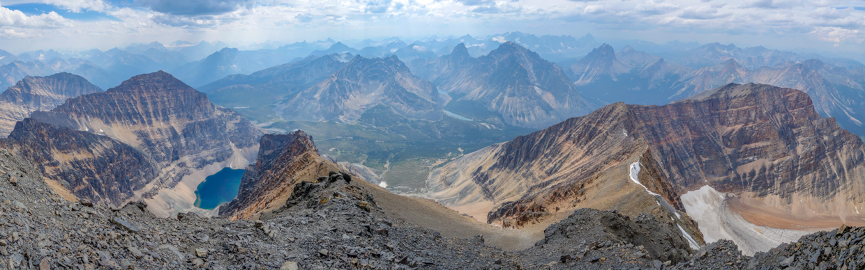
My favorite panorama of the day. 😍 As the sun attempted to break through partially cloudy, partially smoky skies, it cast streaks of light down upon the host of peaks, glaciers, and lakes to the northwest. Click to see larger.
.jpg)
Distant views towards Mount Hooker and the Hooker icefield. Mount Hooker (and nearby Mount Brown) enjoy a mythical history, as they were thought to be the highest peaks in the Canadian Rockies. Indeed, maps showed these peaks as being 4,900-m-tall for over a hundred years (despite the fact that the higher of the two, Hooker, is “only” 3,287 m-tall).
.jpg)
Andrew soaks in the summit scenery. While he’s my senior by a decade and a half, Andrew is indefatigable. While I struggled to stand and take photos atop Edith Cavell, Andrew was already plotting his return for a 3rd trip on a clearer day! For my part, I swore not to come back. 😉
.jpg)
Looking out over Verdant Pass (left), Chevron Mountain (center), Blackhorn Peak (right) and too many glaciers to count…
.jpg)
It’s relatively easy to see how Chevron Mountain likely got its name. Beyond, visible peaks include (from left to right): Beacon Peak, Whitecrow Mountain, Angle Peak and Campus Peak.
.jpg)
Mount Erebus and Simon Peak are the large, glaciated peaks visible beyond nearby Blackhorn Mountain and Throne Mountain.
.jpg)
.jpg)
LEFT: Looking back over the 2,980-m-tall high point that Andrew and I ascended earlier in the day, up the Astoria River Valley towards Oldhorn Mountain.
RIGHT: Looking beyond Oldhorn Mountain towards the famous Ramparts (left) and massive Mount Gelkie (distant right).
.jpg)
Looking north towards Sorrow Peak, we felt no sorrow at the prospect of skipping its summit for today! Immediately behind Sorrow, Chak Peak and Franchere Peak rose up. Andrew seemed to have a curious obsession with the latter because he obviously hadn’t had enough quartzite boulders already. 😂 A little more distant still, glaciated Majestic Mountain, Manx Peak and twin-summitted Indian Ridge were also visible. The latter is actually a pleasant scramble!
.jpg)
A pair of middle-aged men pose for a summit selfie, acutely aware that, much like our lives, this day was just at its mid-point; we still needed to get down and I, in particular, didn’t have much energy left (despite consuming an inordinate number of sandwiches, Clif Bars, apples and peperoni sticks)! How the heck were we going to get back to our car at that little Lake below?
.jpg)
Yours truly starts the long scramble down, one step at a time, and trying not to take any of those steps too close to Edith Cavell’s steep, loose north face. Much of this rock was probably covered by permanent ice and snow not long ago and now, with them gone, it didn’t look like there was much holding it all up! The constant sound of rockfall throughout the day corroborated this assessment… In fact, one need not dig too deep into recent Jasper history to find an example of a cataclysmic release from this precarious face. Back in 2012, an entire glacier fell suddenly off of it, causing a destructive tsunami when it hit the Cavell Pond below. (photo courtesy Andrew Nugara)
.jpg)
The reverse view (this time me taking a photo of Andrew atop the manky north face on his way down the west ridge towards the false summits).
.jpg)
After descending the tame backside of the false summits, Andrew negotiated this awkward (but easy) down-sloping rock band, before completing the side-hilling scree traverse back towards the west ridge.
.jpg)
Andrew methodically picks his way through the west ridge’s boulders towards the Edith Cavell-Sorrow col ahead. From here, we had the option to continue along the ridge towards Mike Mitchell’s scree-filled Sorrow descent route or to bail straight down the climber’s descent that begins near the col. Low on fuel and eager to lose elevation, we elected to go with the latter.
.jpg)
Boulders, boulders everywhere… It was at this point that my right knee started to hurt with every step. While this was less than ideal, it took my focus away from my back pain at least! 🤷♂️ (photo courtesy Andrew Nugara)
.jpg)
Near the col, we stopped for a parting view back down towards the spectacular Angel Glacier and the iceberg/serac-filled Pond below it. 🤩
.jpg)
Andrew starts down the conventional climber’s descent route (dislodging some truly impressive boulders along the way). The upper section of this route was completely non-technical, but it was impossible not to bring half the mountain down with every step that we took! You definitely wouldn’t want to come up this way if climbers were starting down it! For our part, Andrew and I spread out on the slope to avoid peppering one another with death boulders. ☠️ We wore helmets, of course, but given the size of the rocks we dislodged, these were decorative at best! 😬
.jpg)
Trying not to kill Andrew with near-constant rockfall (he was, after all, my ride home)! 🙃 (photo courtesy Andrew Nugara)
.jpg)
About one third of the way down Edith Cavell’s west bowl, the route slowly angled to the skier’s right where a (sometimes wet/sometimes dry) water course provided the least suicidal way down to the much mellower meadows below.
.jpg)
.jpg)
LEFT and RIGHT: Picking our way down step-like ledges by wandering back and forth on either side of the watercourse. The scrambling here was actually really fun (except for the fact that every step hurt my right knee and my back)! Despite appearances, there were always easy ways down the ledges if you looked for them. Bonus points if you can spot Andrew (way ahead of me and having a blast) in the right-hand image.
.jpg)
Easy does it. One step at a time… The only issue was there were a lot of steps! (photo courtesy Andrew Nugara)
.jpg)
Although my old man aches limited me to a sloth-like pace during our descent of the west bowl, the fact that its 700 vertical meters took us only an hour and a half, suggests that I was still moving somewhat capably. Without me, Andrew probably would have been down in an hour. Still, he was good enough to wait for me (over and over again), and we soon reached the bottom of the rubble heap and were able to stare back up, happy to be off it and onto much easier terrain! 🙏
.jpg)
Lovely late evening views towards Chevron Mountain, Blackhorn Peak and Throne Mountain from the tarn at the base of the climber’s descent route. The descent trail actually by-passed this tarn but Andrew was still energetic enough to make the small side-trip to its shores. For my part, I elected to minimize unnecessary wandering and simply stole his photos after the trip. 😂 (photo courtesy Andrew Nugara)
.jpg)
With the mountain of rubble behind us, it started to feel as though our day was drawing to a close, however, this was literally far from the truth, as we still had to hike 9-km to get back to the trailhead! At least the views were good (for the 1st of those 9-km, anyways)!
.jpg)
.jpg)
LEFT: Edith Cavell towers imposingly above a small creek in the massive cirque. This meadow proved to be a nice spot to enjoy my 5th lunch of the day 🥪 (sometimes referred to as dinner).
RIGHT: Once I’d eaten what little food I had left, it was time to GTFD! While I felt slow on the descent route’s blocky terrain, this path suited my sore knee and back better and I set a good pace, motivated to finish the hike out before the hostel’s 10 pm check-in deadline.
.jpg)
After tripping on roots and hopping over logs for 5-km on the Verdant Pass spur trail, we reached the highway-like Astoria River trail, which we had to follow gently uphill for the last 4-km of the day. The look on my face here aptly sums up how I felt about that (after having already hiked/scrambled 21-km and 1,800 vertical meters)! Yes, that’s right. We have a new entry in this website’s growing “FML” photo database (1, 2, 3)!
.jpg)
.jpg)
LEFT: That’s better! 🙏 After settling into a mind-numbing rhythm on the well-travelled Astoria River trail, we reached its end at the outlet of Cavell Lake after only an hour and were able, at last, to look up at the distant-looking summit in wonder. We’d just been up there 5-hours earlier! 🤯
RIGHT: Better still! There were a couple of celebratory beverages waiting for us in a cooler at the trailhead! 🍻 By the time that we cracked them, it was 9 pm (13-hours after we’d started hiking and 18-hours after we’d left Calgary). Exhausted, 😴 we were very pleased with our earlier decision to book a couple of beds in the dorm of the HI Edith Cavell Wilderness Hostel (which was conveniently located right at the trailhead!
.jpg)
Since I provided the refreshments, Andrew graciously supplied our “dinner” at the hostel. And what a dinner it was! I’ve never tasted such magnificent Oreos and chips! Truly a feast fit for a 40th birthday celebration! 🥳 With bellies full and thirst quenched, we retired to our dorm and thanked God that there were still bottom bunks available. I don’t think either of us would have managed to climb up to the top bunk if our lives depended on it! 🤣 1,900 vertical meters was enough for these two old men!
Epilogue
After an epic Edith Cavell suffer-fest (and an equally epic night’s sleep at the Edith Cavell hostel), Andrew and I both woke before dawn on my actual 40th birthday. The plan for this day was simply to drive back to Calgary, so that I could celebrate with friends and family. Clear skies and amber alpenglow, however, prompted us to make a quick side-trip to nearby Cavell Pond, the magnificent blue tarn we’d seen from over 1,500 meters above the day prior.
.jpg)
.jpg)
LEFT: The pond’s icy blue waters were as spectacular from below as they had been from above! Filled with icebergs from the calving Cavell Glacier and water from the Angel Glacier above, this serene scene made for a fine start to my forties! 😊
RIGHT: A closer look at the Angel Glacier’s seracs, hanging precariously above.
.jpg)
As we sat at the pond, the sun’s amber glow slowly made its way down Mount Edith Cavell’s massive north face. The only thing more fulfilling than watching this spectacle unfold, was the knowledge that we’d endured the previous day’s climb, and earned the reverse view from this big, beautiful, bucket-list peak’s summit high above. From its base to its summit, Edith Cavell was magnificent and made for a most memorable 40th birthday celebration.
.jpg)
Yours truly models the latest in hiking footwear for middle-aged men. 👴 After 13-hours in my boots the day prior, there was no way in hell that I was putting them back on today! 😂 After an hour or so along the shores of the Cavell Pond, I remembered why sandals are a poor choice for zero-degree mornings, and suggested that we retrace our steps down the short “Path of the Glacier” hike. With the heat on in Andrew’s car, I watched the mountains pass during our drive home, tired by yesterday’s efforts but still deeply satisfied with my 40th birthday present: Mount Edith Cavell! 🎁
.jpg)
After a pleasant drive home, I spent an enjoyable birthday afternoon with my wife and kids and was looking forward to a long-planned birthday dinner with them at Brewster’s. After all, the only thing that I like more than an epic mountain is a burger 🍔 and beer, 🍺 after an epic mountain. Arriving at the restaurant’s sunny patio, I was “surprised” by a small group of amazing family and friends, who my wife had secretly invited. Forty may be achy and it may not have unfolded as I’d planned, but my wife, my family and my friends made this a truly memorable milestone ❤️ (and the poor devils had to listen to me talk about Mount Edith Cavell the whole time)! 🙃
Here’s to my forties, the peaks they’ll bring and, more importantly, the people I’ll get to enjoy them with!
.jpg)
.jpg)
.jpg)
.jpg)
.jpg)
.jpg)
.jpg)
.jpg)