Why do I snowshoe up mountains and peaks? The answer is simple: snowshoes allow me to experience the mountain-top adventures ⛰️ that I love during our long Canadian winters. ❄️ They allow me to catch up with like-minded friends, while revelling in spectacular winter scenery. Having said that, snowshoes REALLY suck! They’re heavy. They’re cumbersome. They make me waddle 🐧 like a much fatter man than I am. Worse yet, they often fall well short of their purpose (particularly when the snowpack is made up of unconsolidated sugary crystals). There’s nothing quite as vexing as freezing your fingers to strap on a pair of ‘shoes, taking a step, and then immediately sinking down to your waist! Now, not only are the snowshoes not helping you to float atop the snow, but they’re actively scooping it, and making it more difficult to pull yourself back up! 🤬 Ah snowshoes.
Having not used my snowshoes since January 2023, I (of course) forgot all of the latter points while keenly remembering only the former… So, when fellow Matt/Mountain Man/PhD Chemist Dr. Clay reached out to see if I’d be interested in a “dumb idea” (also known as a snowshoe 😂) over the holidays, I replied in the affirmative!
While some genuinely “dumb ideas” were discussed, we eventually settled on a target that seemed downright reasonable: one of the outlying peaks on the ridge south of Mount Kent. The lowest outlier on this end of the ridge is quite popular and usually has a packed trail all winter-long. Of greater interest, extending our day further up the ridge towards Mount Kent promised to be a scenic endeavor (particularly with PERFECT weather forecast)! 🌞 Since Matt C. had already snowshoed this route a time or two, I did NO research on the objective 🤷 and, for some reason, assumed that it required an elevation gain of about 500 m. “Nothing to it!”: I naively thought as Matt C., his partner Sandra and I giddily drove west towards Kananaskis. Ignorance is, of course, bliss until you find yourself waist-deep in it with snowshoes weighing you down… 🤔
.jpg)
Rounding a random bend on the Smith-Dorrien trail (about 5.1-km from the junction with Kananaskis Lakes Trail), we spotted an old ‘shoe track, which climbed steeply uphill in the direction we wanted to go. Since there’s no shoulder here during winter months, we pulled over as far as we could and geared up in a snowbank. As we donned gaiters and microspikes, Matt C. naively asserted that the obviously overcast sky would clear as forecast (even going so far as to PROMISE that this would occur within an hour). The man who coined the term “Environment Canada parlance for Clear and Sunny” should have known better…
.jpg)
.jpg)
LEFT: Matt C. and Sandra set off up the, initially, steep slope above the road (optimistic that the patch of blue sky overhead is part of a greater clearing trend and not simply a “sucker hole”).
RIGHT: Into the typical K-Country forest. Even without the packed trail, there wouldn’t have been enough snow at this elevation to justify snowshoes…
.jpg)
After amusing himself by removing flagging tape (which needlessly littered hundreds of trees adjacent to the OBVIOUS track), Matt C. (and Sandra and I) emerged into a series of clearings. While we all enjoyed the clearings’ more open surroundings, only one of us did so with a massive ball of flagging tape in his pocket… Or was Matt C. just REALLY happy to be snowshoeing? 🤔
.jpg)
As we steadily gained elevation, we enjoyed improving views across the Smith-Dorrien Valley towards nearby Mount Warspite. Although we’d been moving for nearly 2 hours at this point, the clearing skies that Matt C. had been SO confident about had, as of yet, failed to manifest. 🤔
.jpg)
Emerging into a subalpine clearing, Sandra spotted the “Kent Ridge South Knob” just ahead. This feature is about 550 vertical meters above the road, and is as far up as most folks venture. From this point on, our progress slowed as we regularly punched through the broken trail up to our shins and knees, stubbornly refusing to stop so that we could don our snowshoes.
.jpg)
After acknowledging that we REALLY should have put snowshoes on for the last bit, we eventually reached the top of the knob and were greeted by a blustery winter panorama of the Smith-Dorrien Valley. Those with keen eyes may be able to spot the inexplicably popular Blackshale Creek Suspension bridge in the drainage far below. Click to see larger.
.jpg)
.jpg)
LEFT: Despite the bitter wind, I was enamored with the manner in which Blackshale Creek curved dramatically downhill towards Mount Invincible. Unfortunately, this shot cost me the feeling in my fingers (which quickly froze despite still having gloves on)! Does this make me a “knob” on a Knob?
RIGHT: While I dicked around taking photos and freezing extremities, Matt C. and Sandra smartly sheltered from the wind and readied themselves for the next stage of our adventure: up South Kent Ridge, which is visible behind them here.
.jpg)
Descending the Knob’s backside and slowly making our way towards Kent Ridge South (center). Beyond the Knob, there was no broken trail and snowshoes were no longer optional. There was definitely snow at this elevation! At first, the going was relatively easy (since we were in the process of losing about 60 meters elevation)…
.jpg)
… Eventually, what goes down had to go back up, however, and our pace plummeted as we sunk knee-deep into unconsolidated sugar snow with every step, pawing futilely upwards as the snow collapsed around us. Worse still, it wasn’t just us collapsing through the snow, as there were a dozen instances where the entire snowpack collapsed all around us with an impressive “WHUMPF.” For those unaware, this is a telltale sign of slope instability and, therefore, avalanche danger. We were, therefore, VERY careful to plot a plodding course up the gentlest and safest terrain features possible to avoid any features that could slide.
.jpg)
While the going up Kent Ridge South was genuinely MISERABLE, the skies did actually start to clear (better late than never), and improving views east towards the Opal Range motivated us to continue suffering upwards. Click to see larger.
.jpg)
Sandra and Matt C. cross a gully-like feature. Above them, windblown alpine slopes meant that snowshoes were, mercifully, no longer needed! Of interest, note who has finally taken on the lead position and its requisite trail-breaking! 😝 (Says the guy who took photos from the back of the pack. 😏)
.jpg)
Matt C. microspikes his way up a mix of windblown rock and grass as we near the ridge crest under *GASP* clearing skies!
.jpg)
Following a short jaunt along the relatively level ridge crest, we reached a cairned high point whose cornice-filled scenery prompted Matt C. to stop for a photo shoot. Work it Dr. Clay!
.jpg)
Sandra’s turn to model atop the precipice. While most intelligent human beings would probably stop here, Matt C. assured us that the next high point (visible in the sunlight on the right) was much closer and easier to get to than it looked, so… 🤷
.jpg)
… We continued onwards and upwards alongside increasingly dramatic cornices despite wavering energy levels. 🥵
.jpg)
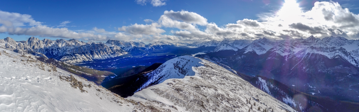
Fortunately, Matt C.’s assessment was atypically accurate, and the next high point was both easily gained and the most scenic yet! For proof, check out this magnificently cornice-filled panorama north towards Mount Kent (center). 🤩 Click to see larger.
.jpg)
To the west, Mount Black Prince’s long north ridge (and precipitous east face) stretched across much of the panorama.
.jpg)
While the skies to the east largely cleared, Mount Smith-Dorrien’s gracefully serpentine southeast ridge seemed to slither in an out of more persistent clouds to the west. To the right of Smith-Dorrien, Prairie Lookout and Mount Murray also enjoyed perpetual cloud caps.
.jpg)
Looking up the Smith-Dorrien Valley towards Canmore. Visible peaks include (from left to right): Commonwealth Peak, Pig’s Back, The First, Gibraltar Rock, Cave Mountain, Og Mountain, Tent Ridge and Cone Mountain.
.jpg)
The reason I bother to snowshoe! 🤷😁 Reveling in the spectacular winter scenery “On Top” of Kent Ridge South. In principle, it was tempting to investigate the 1-km traverse to the official summit of Mount Kent. In practice, however, I was totally knackered. 🥵 Fortunately, others have reported difficulties (including steep, snow-covered slabs) on this traverse so we had a convenient excuse to call it a day here! 😂 Besides, the REAL summit of Kent Ridge is still 5-km north of Mount Kent anyways!
.jpg)
Panoramic views east over the Kent Creek Valley towards the more distant Opal Range. Is it just me or does that valley look REALLY long from up here? 🤔 Click to see larger.
.jpg)
Mounts Inflexible (center) and Lawson (right) at the head of the Kent Creek Valley.
.jpg)
Opal Range peaks: Mount Packenham (center left), Mount Hood (center) and Mount Brock (right) rise dramatically above diminutive-looking King Creek Ridge.
.jpg)
Looking back along our corniced ascent ridge, the panorama stretched from the easterly Opal Range, over the Kananaskis Lakes and Elk Pass, to the westerly Spray Range. Click to see larger.
.jpg)
Dramatic views of glacier-sculpted Opal Range peaks beyond wind-sculpted snow to the southeast.
.jpg)
Looking south, beyond the snow-covered Kananaskis Lakes towards the perpetual inversion on the BC side of Elk Pass. In the foreground shade, the Knob that we’ll soon need to snowshoe back out to, over and down the other side of suddenly looks very far! 👀
.jpg)
Atmospheric and moody winter views southeast towards Mount Indefatigable (center left), Mount Invincible (center) and Mount Warspite (center right).
.jpg)
Golden light and icy gusts make for a dramatic scene over Mount Warspite.
.jpg)
A final group summit shot before reluctantly beginning our wintry trek down. The reason that we’re all SMILING here is that no one is currently wearing snowshoes! 😉
.jpg)
Enjoying panoramic (snowshoe-less) views towards the Kananaskis Lakes, while making our way back down the ridge in the late afternoon light. Click to see larger.
.jpg)
As we neared the point where snowshoes would soon be needed, Matt C. briefly thought about taking a shortcut down. No snowshoes need this way! 😉☠️😂
.jpg)
Wandering back towards Kent Knob (which still looks very far away here) as the long, cold shadow cast by the Spray Range stretches across the Smith-Dorrien Valley.
.jpg)
The Spray Range’s long shadow finally caught us as we reached the Knob and endured the short snowshoe back up and over it (cleverly side-hilling around its high point to save a few meters of elevation). By this point, my out-of-practice snowshoeing muscles were screaming for mercy and my troublesome back wasn’t much happier. 😖 The hour-long descent which followed ended up being a bit of a “grin and bear it” affair, filled with “old man noises” and exasperated “sighs”. 👴😣
.jpg)
After surviving the packed trail down through the unremarkable forest, I was relieved to reach the road as the fading sun painted the west faces of the Elk Range with its final rays. 😌 Back at the car, the strain of the day’s efforts soon faded thanks to a cozy seat heater and a hearty snack. Forgetting the panting, the post-holing and the pain, my day-dreaming mind wandered back to the spectacular cornices and peaks above. As the sun set to the west, my energy returned and Matt C. and I spent the rest of the drive home discussing our next “dumb idea”…
.jpg)
.jpg)
.jpg)
.jpg)
.jpg)
.jpg)