Nigel Peak
Elevation: 3211 m
Elevation Gain: 1175 m
Nigel Peak was named by Normal Collie for his packer Nigel Vavasour. Collie and Vavasour were members of the first major climbing expedition to reach the upper Saskatchewan region in 1897. Together, they climbed Mount Athabasca and were the first Europeans to lay eyes upon the Columbia Icefields. The peak was first ascended by the Interprovincial Boundary Commission in 1919. Accordingly, the summit ridge of Nigel Peak forms the boundary between Banff National Park and Jasper National Park.
My Ascents:
August 3 2010
After a busy start to the August long weekend (Saturday: Grizzly Peak, Sunday: Mount Fairview, Monday: Windtower and Rimwall Summit), it was time to finish it off in style and celebrate my 27th birthday with my fifth summit in four days. Occasions as grand as my birthday of course call for very long drives up to the Columbia Icefields where Grant and I decided that we would celebrate by groveling up an excessive amount of scree under (sadly) overcast skies.
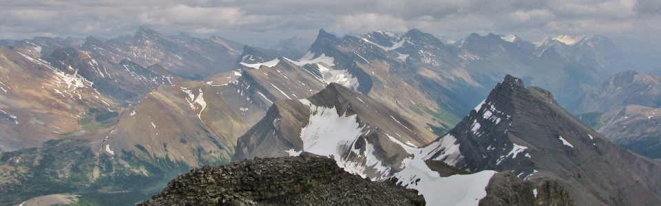
.jpg)
Early views of our objective Nigel Peak from the Wilcox Pass trail. Still a long way to go!
.jpg)
Breath-taking views of the Columbia Icefields across the valley.
.jpg)
So begins the scree...a 700 m vertical scree chute provides an unpleasant 'warmup' on ascent.
.jpg)
Fast-forward to the top of the saddle at the top of the scree chute (1.5 hours later). That's a lot of f*cking scree.
.jpg)
Grant unwinding after the vicious scree ascent. Still more scree to climb at the base of the summit cliffs!
.jpg)
The scree- and snow-filled route up from the saddle.
.jpg)
Athabasca Glacier.
.jpg)
Snow coaches making their way up the Athabasca Glacier.
.jpg)
Impressive views to the south including Mount Saskatchewan.
.jpg)
Mounts Athabasca and Andromeda high above the icefields.
.jpg)
Distant glaciers on Mounts Wooley and Diadem.
.jpg)
Athabasca provides a spectacular backdrop as we make our way towards the summit.
.jpg)
Crossing steep snow slopes. Good thing he has his walking stick 'Larry' out and his ice axe holstered still...
.jpg)
The view from Nigel's northwest ridge. Impressive snowfield in the foreground.
.jpg)
Beautiful orange peaks to the east.
.jpg)
Orange peaks to the east over blue tarns.
.jpg)
A nasty section of Nigel's northwest ridge. Rotten rock or steep, deep snow?...
.jpg)
Pinnacle near the summit.
.jpg)
At last we're up! Looking south along the Icefields Parkway.
.jpg)
Glacier, glacier everywhere...
.jpg)
Mighty Athabasca and Andromeda.
.jpg)
Looking south to Sunwapta Pass, mighty Mount Saskatchewan and diminutive Parker Ridge.
.jpg)
Looking north towards Jasper. The smaller Mount Wilcox across the green pastures of Wilcox Pass.
.jpg)
A long way down the glacier on Nigel's backside!
.jpg)
Beautiful tarns and peaks to the east.
.jpg)
Admiring the blue waters of a tarn.
.jpg)
More tarn action.
.jpg)
The Dome Glacier.
.jpg)
Mount Alberta makes an appearance.
.jpg)
Mount Wilcox behind Wilcox Pass and Wilcox Lake.
.jpg)
Small glacial Lake at the foot of Mount Athabasca. Hilda Peak in the foreground on the left and Boundary Peak in the foreground on the right.
.jpg)
Happy birthday at 3211 m!
.jpg)
Grant wants you...
.jpg)
High above smaller peaks to the east.
.jpg)
Columbia Icefields panorama. Left to right: Athabasca, Andromeda and the Snow Dome.
.jpg)
Wilcox panorama.
.jpg)
Eastern panorama.
.jpg)
Signing the summit register.
.jpg)
Happy birthday to me!
.jpg)
Altitude-induced silliness?
.jpg)
More battle damage...
.jpg)
Time to head down before the weather turns! On the way up, we had heard a couple of distant thunder rumbles. Fortunately, the weather did not close in while we were up high!
.jpg)
Grant on the northwest ridge above Wilcox Lake.
.jpg)
Slight exposure...
.jpg)
Making his way down steep, brutal rock.
.jpg)
I had a lazier idea. An uncomfortable steep glissade! Time to test out those new ice axes (birthday presents)...
.jpg)
Some hands-on moves on the ridge.
.jpg)
Avoiding scree in favor of a wet bum.
.jpg)
Glissade!
.jpg)
Crossing snow slopes on descent.
.jpg)
The Snow Dome in the background.
.jpg)
Great views of the North Twin and Twins Tower.
.jpg)
Glaciers!
.jpg)
Close-up of the aptly-titled Snow Dome. The Snow Dome bears the distinction of being the only peak whose melt water runs into three different oceans.
.jpg)
Close-up of Athabasca's summit (left) and Silverhorn (right).
.jpg)
Back down to the saddle above the scree. Wilcox Lake is a lot closer now!
.jpg)
Impressive glacier-carved peak near the saddle.
.jpg)
Scree-ing off the edge of the world! What followed was one of the most exhilarating scree skis of my life as we lost 800 vertical meters of elevation in a period of 16 minutes.
.jpg)
Mount Saskatchewan.
.jpg)
One last look towards the summit cliffs before scree-ing on down.
.jpg)
Grant already half way down to Wilcox Pass in the 2 minutes that it took me to take the last 2 photos.
.jpg)
Grant nearing the bottom of the scree chute. It took us over an hour and a half to grovel up this thing, and less than 16 minutes to come down it.
.jpg)
One hell of a scree slope! You can see our whole route down!
.jpg)
Mount Wilcox over the Pass. Looking at the summit ridge of this one reminds me why it scared me when we did it a few years ago!
.jpg)
Views from the Pass.
.jpg)
Smaller peak to the south from the Pass.
.jpg)
Birthday Peak!
.jpg)
'Canadream' RV in the parking lot. After getting stuck behind a dozen of these things on the windy two lane highway on the way up, we decided that 'Cananightmare' was more appropriate.
.jpg)
Grant making his usual haste. Since Nigel Peak wasn’t enough exercise already, we decided to jog up to the toe of the Athabasca Glacier.
.jpg)
While we were in the neighborhood, we paid a quick visit to the foot of the Columbia Icefields.
.jpg)
Cool glacier!
.jpg)
The other side of Mount Wilcox showing the route up the exposed ridge.
.jpg)
Nigel Peak!
.jpg)
Eat your heart out Gord! 616.8 km on a half tank of gas!