Mount Niblock
Elevation: 2976 m
Elevation Gain: 1260 m
Along with adjacent Mount Whyte, Mount Niblock forms the scenic backdrop to Lake Agnes. Mount Niblock was first ascended in 1899 by Walter Wilcox. In 1904, the peak was named for John Niblock the western superintendent of the Canadian Pacific Railway. Niblock was an early promoter of tourism in the Rockies and was responsible for naming many stops along the railway including Claresholm which was named for his wife (Clare’s home).
My Ascents:
September 12 2009
With perfect weather and clear skies forecast, Grant and I decided that a trip out to the grand scenery of the Lake Louise area was in order! Following the customary morning pit stop at Laggan’s, we were ready to launch our campaign on Mount Niblock!
.jpg)
Elbowing our way along the crowded Lake Louise path (crux, sort of...).
.jpg)
Mount Victoria behind Lake Louise.
.jpg)
Early views of Mount Lefroy on ascent to the Lake Agnes teahouse.
.jpg)
Crowds at the teahouse!
.jpg)
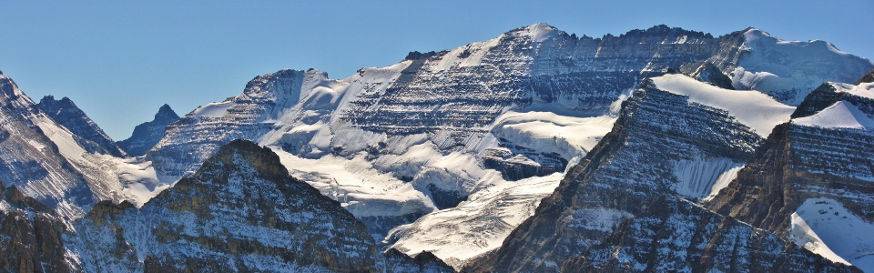
Examining the target: Mount Niblock in the sun. It's counterpart Mount Whyte in the shade.
.jpg)
Approaching the first series of obstacles...
.jpg)
Attempting to chart a safe course through the rock band.
.jpg)
Looking back towards Lake Agnes from midway up the rock band.
.jpg)
The fun never stops!
.jpg)
The sun rising over Mount Whyte's sheer face.
.jpg)
First views of Lake Louise below Lake Anges.
.jpg)
Mount Whyte.
.jpg)
Approaching the Niblock-Whyte col: First views of Mount Victoria.
.jpg)
Mount Whyte dominates the panorama as we gain the col. From left to right: Mounts Fairview, Sheol, Haddo, Temple, Whyte and Victoria. Click to see larger.
.jpg)
Skirting the base of Niblock's summit cliffs en route to the col.
.jpg)
The moon, still in plain sight as we attain the col.
.jpg)
Gorgeous views from the col.
.jpg)
More gorgeous views from the col.
.jpg)
Panorama from the col. Click to see larger.
.jpg)
Things getting a little more technical along the Niblock summit ridge.
.jpg)
Grant negotiating a narrow bit along the summit ridge.
.jpg)
Another couple of scramblers tackling the exposed ridge.
.jpg)
Watch your step!
.jpg)
One last narrow bit to go...I may or may not have crawled somewhere along this ridge...
.jpg)
Best summit shot ever!
.jpg)
The col between Mounts Lefroy and Victoria: site of Abbot's hut.
.jpg)
Abbot's hut perched precariously atop the glacier.
.jpg)
Panorama of the Lake Louise group. From left to right: Fairview Mountain, Panorama Ridge, Mount Temple, Haddo Peak, Mount Aberdeen, Mount Tuzo, Deltaform Mountain, Neptuak Mountain, Mount Lefroy, Mount Biddle and Mount Victoria. Click to see larger.
.jpg)
Mount Victoria.
.jpg)
The Victoria glacier.
.jpg)
The Deltaform rises up behind Mount Whyte.
.jpg)
Grant trying to determine the origin of the name 'Niblock'.
.jpg)
Narao Peak?
.jpg)
Mount Temple looms above Haddo Peak and Aberdeen.
.jpg)
Looking into British Columbia. From left to right: Mount Field, Mount Wapta, Mount Canaveron, and the glaciated President.
.jpg)
Closer view of Mount Wapta and the President. site of the Burgess shale.
.jpg)
Mount Stephen's 2 km sheer north wall rising up from the other side of the continental divide.
.jpg)
North Victoria.
.jpg)
Awesome crevasses.
.jpg)
Clear skies over the Wapta Icefield.
.jpg)
Mounts Daly and Balfour.
.jpg)
Icefields panorama including: Mount Niles, Daly and Balfour atop the Waputik (foreground) and Mounts Mummery and Forbes (background). Click to see larger.
.jpg)
Looking up the Icefields parkway. From left to right: Observation Peak, Cirque Peak, and the Dolomites beyond Bow Peak.
.jpg)
Lakes Agnes and Louise from the summit.
.jpg)
Not quite larch season yet...
.jpg)
Grant growing weary of my photography.
.jpg)
Grant preparing to leave the moon and the summit behind.
.jpg)
Exercising a little care as he begins his descent.
.jpg)
Enjoying the exposed ridge.
.jpg)
Grant overlooking the Lake Louise panorama.
.jpg)
Mount Victoria. Click to see larger.
.jpg)
Taking it in.
.jpg)
Token summit photo before heading down!
.jpg)
Grant waiting for me to put my camera away.
.jpg)
An interesting choice of places to sit and wait....certainly can't knock the view though!
.jpg)
Bits of the exposed summit ridge from the other side. On descent we used a gully to the skier’s right of the ridge. When dry, the gully offers an easier route down (and up), however, even on a hot September afternoon, there was still some ice in it.
.jpg)
Taking an important call from Dennis Butcher.
.jpg)
Looking back to the summit from the col. Easy but potentially icy gully far too the climber’s left. We stuck to the ridge crest on ascent and found it pleasant as well.
.jpg)
Back off the summit ridge, looking back up the cliffs we would have plunged off of had we slipped.
.jpg)
Lake Agnes in the fading afternoon light.
.jpg)
Another one bites the dust! Now to run down the dull approach hike from Lake Agnes to make it down in time for happy hour!
.jpg)
.jpg)
.jpg)
.jpg)
.jpg)