Mount Lawrence Grassi
Elevation: 2685 m
Elevation gain: 945 m
In addition to its summit, Mount Lawrence Grassi features 2 named peaks (Ha Ling Peak to the northwest and Ship’s Prow to the southeast). The mountain, like the small lakes at the base of Ha Ling’s north face) was named for a well-liked Canmore miner and mountain guide. Grassi emigrated from Italy in 1912 and worked as a coal miner in Canmore. He would often spend his days off ascending peaks (including an impressive 32 ascents of Mount Louis and the first solo ascent of Mount Assiniboine). In an effort to share his love for the mountains with others, Grassi took it upon himself to expertly craft many hiking trails (including those in the Lake O’Hara area).
My Ascents:
October 13 2007, July 2 2010
Seeking someone with whom to hike up the Windtower, my uncle Peter asked if I’d join him for a day in the mountains. My answer was, of course, “yes” but since the Windtower was not included in Kane’s guide, I wasn’t (at that time) keen to climb it. After a little lobbying, I was able to persuade my uncle that Mount Lawrence Grassi would be a good target. Having always looked up at it from Ha Ling, it didn’t take much arm-twisting to get him to change his original plan. Unfortunately, we were unable to leave Calgary until the afternoon as a result of a work commitment that Peter had made. It was already mid-afternoon by the time that we reached the parking area and soon we were making haste along the canal towards the base of Lawrence Grassi where we started to bushwhack unnecessarily (route-finding note: there’s a good trail on the climber’s left side of a boulder-filled drainage at the base of the ascent ridge; look for flagging and cairns – the trail is well-travelled). Despite the late start and unnecessary bushwhacking, we ended up being treated to a spectacular fall day (and night) in the mountains but learned a couple of valuable lessons along the way: 1) Get an alpine start for October scrambles! 2) If you ignore 1), bring a head lamp!
.jpg)
After a long slog up below the tree line, the views across the gap towards Mount Rundle finally start to open up.
.jpg)
Looking up towards the summit blocks of Mount Lawrence Grassi.
.jpg)
Looking back down the Lawrence Grassi ridge towards Spray Lake and canal. The ridge had a nasty habit of forcing one to down climb every few hundred meters. Fortunately, these down climbs were more annoying than difficult.
.jpg)
Peter catching up! That can only mean that I’ve been stopped taking photos for too long!
.jpg)
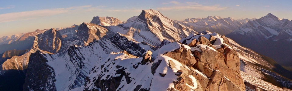
A splendid summit view looking towards the Three Sisters from one of the two summits of Lawrence Grassi. The other summit is immediately in the foreground, and looks to be at the exact same elevation as that from which the photo was taken.
.jpg)
Summit cairn on Lawrence Grassi, looking down at Ha Ling and the East end of Rundle.
.jpg)
Mounts Rundle and Cascade.
.jpg)
Peter on the summit push.
.jpg)
At this point I've got the summit poses down to a science.
.jpg)
Peter at the summit of Lawrence Grassi, towering above Ha Ling and the East end of Rundle.
.jpg)
Lunch time (as the sun begins to set)! It was FREEZING!
.jpg)
The alpen glow begins to overtake the Big Sister...we may have gotten a later start than we should have...time to get down before it's dark!
.jpg)
The sun dips behind the mountains on the opposite side of the Spray lakes valley...note how high up we are still...uh oh. Looks like we'll be pulling a Sonny Bou!
.jpg)
A high point between Lawrence Grassi and Ha Ling caught in the alpen glow.
.jpg)
Mount Rundle at twilight.
.jpg)
It's getting alarmingly dark and we foolishly do not have headlamps.
.jpg)
Surprisingly we weren't the last ones on the mountain. One foolish party summited as the sun was setting. I think they may have stayed up there and enjoyed the sunset with a few beers.
.jpg)
The two summit blocks of Mount Lawrence Grassi complete with a foolish party at the top. It may not look exposed but the section where the ridge narrows feels it. Slabby terrain covered with small loose rocks contributes to the precarious feel of this section.
.jpg)
Mount Rundle as the sun sets. So much for my hope that we'd be back at the tree line by the time it got dark...it was a long walk down through the forest in the dark without headlamp. Oddly enough, we managed to find (and mostly stay on) a good trail that we had missed on the way up (when we could actually see)!