Mount Kidd
Elevation: 2958 m
Elevation gain: 1350 m
Mount Kidd was named after Stuart Kidd, a Morley resident who outfitted early Kananaskis expeditions. The peak was named by D. B. Dowling in 1907. Dr. Dowling’s party with the geological survey of Canada would likely have found Mount Kidd to be particularly interesting as the peak represents the northern extremity of the 450 km long Lewis thrust which forced older Precambrian rock over Cretaceous rocks which are 1.4 billion years younger than those which now rest atop them. Mount Kidd has two prominent high points, the more northerly of which is the true summit.
My Ascents:
July 23 2010
Mount Kidd looks really freakin’ cool from the Kananaskis highway. So much so, in fact, that it is featured on the cover of “50 Roadside Panoramas in the Canadian Rockies”. What better reason is there then for wanting to climb a mountain than: “it looks badass”? For this reason alone, Grant and I set out early in the morning to attempt Mount Kidd. If the mountain looks so amazing from the road, surely the summit views will be astounding?
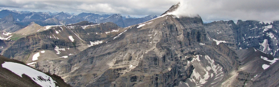
.jpg)
Mount Kidd surrounded by early morning clouds.
.jpg)
Clouds filling the ascent gully.
.jpg)
Grant making his way up towards the ledges on the right hand side of the waterfalls.
.jpg)
Some tricky moves on wet ledges...
.jpg)
Late season snow bridges. Enough to give one second thoughts about glissading higher up.
.jpg)
Grant climbing into the clouds.
.jpg)
The south summit of Kidd and it's crown of clouds.
.jpg)
Rock walls and clouds guarding the north summit.
.jpg)
Snow blocking the proper route. Too hard to kick steps in, it forced us off route onto steep slab rock.
.jpg)
A rock window in the mist.
.jpg)
Interesting pinnacles on North Kidd.
.jpg)
Pleased to be making his way up?
.jpg)
The buttress separating North and South Kidd.
.jpg)
Vicious evil scree. Thoroughly exhausting.
.jpg)
Finally past the scree and onto the summit ridge!
.jpg)
Lunch amidst the clouds.
.jpg)
The scenic telecommunications repeater on the summit...
*sigh* Is cell phone reception worth this?
.jpg)
The lush green valleys of Mount Allan contrasted with the harsh limestone of Mounts Sparrowhawk and Lougheed.
.jpg)
The east-most summit of Mount Lougheed (left) and Mount Allan (right).
.jpg)
Spray Valley to the west.
.jpg)
Interesting geology on Mount Bogart (pour Aurore).
.jpg)
Another summit crossed off the list!
.jpg)
High above multiple Olympic Summits...
.jpg)
Dwindling summit cornice.
.jpg)
The Wedge, Opal Ridge and the Kananaskis Valley to the south.
.jpg)
Looking north to the prairies.
.jpg)
Prairie through a gap in the clouds.
.jpg)
Opal ridge, showing the viciously steep ascent 'meadows' to the left of the road. Kane's description of the route up there leaves something to be desired...
.jpg)
Sick of clouds, and heading down!
.jpg)
The Fortress through the clouds.
.jpg)
The summit of Mount Bogart was obscured all day.
.jpg)
The most we could see of Bogart.
.jpg)
Sparrowhawk was similarly socked in.
.jpg)
K-Country.
.jpg)
Super bad ass fossil!
.jpg)
The Chester Lake scrambles in the distance. Left to right: Fortress, Mount Chester, Gusty Peak, Mount Galatea.
.jpg)
Finally a somewhat clear view of the Fortress!
.jpg)
Off route and trying to use our Mantracker skills to find some semblance of a trail...
.jpg)
Not the same way we came up...annoying slab rock on descent.
.jpg)
The snow that foiled all our attempts to stay on route both on the way up and on the way down...we went up to the right of it, and ended up coming down on the left.
.jpg)
The Wedge looking more prominent as we descend.
.jpg)
Grant making his way back down the gully.
.jpg)
Wedge Pond below the...well, you know.
.jpg)
The sharp drop-off above the waterfalls.
.jpg)
Finally a clear view of the waterfalls and South Kidd above them.
.jpg)
Gorgeous wildflowers.
.jpg)
Mount Kidd from the Kananaskis River. All clear on top now...
.jpg)
Rehydrating at Woody's Kananaskis with Mount Kidd in the background.