CREAK. SQUEAK. CREAK. SQUEAK. CREAK. SQUEAK.
There is no need for an alarm clock ⏰ when you stay at the Skoki Lodge because the slightest movement of any guest, anywhere on the Lodge’s second story floor produces so loud a noise, that you’ll swear it’s coming from inside your own room!
Luckily, my Mom (AKA “Grandma”) and I hadn’t come to Skoki to sleep in. We’d come to celebrate her 70th birthday 🎂🥳🎈, and we planned to do so by exploring Skoki’s many, beautiful valleys. As such, the rustic floorboard alarm conveniently ensured that we got off to an alpine start, following each of the 3 nights that we stayed at the historic Skoki Lodge.
.jpg)
.jpg)
As Day 2 of our trip dawned, we CREAKED and SQUEAKED our way out of our upstairs room and made our way downstairs. After our morning coffee and tea ☕ on the banks of the rain-swollen Pipestone River, we enjoyed a glorious breakfast inside and got to know some of the fellow CREAKERS and SQUEAKERS staying at the Lodge. While we were already intent on hiking, the rich meal’s many calories ensured that we pretty much had to now. The question was: what to hike?
Eavesdropping on others’ conversations about the hikes that they’d done, Grandma decided that the “Skoki Circuit” sounded like a good plan for Day 2. The 11-km Circuit was on the longer side of what she wanted to do, but she figured that doing it today would allow us to save an easier, shorter hike for Day 3 before our grand egress hike on Day 4. Intrigued by the “Skoki Circuit,” fellow lodge guest Tamara expressed interest in joining us. Since we’d enjoyed chatting with her at breakfast, we agreed, and Tamara became the first addition to our Skoki posse. 🤠
.jpg)
After taking care of some pre-hike “business” (avert your eyes, outhouse marmot!), we met Tamara in front of the Lodge and set off towards the Merlin Meadows to start the Circuit in a clockwise manner. At this point in the hike, navigation was easy as Parks Canada actually posted usable signs! 🤯 This would not always be the case later on…
.jpg)
Initially, the trail wandered through the woods and lost elevation. It was not especially inspiring but, fortunately, we had lots to chat about as we got to know Tamara. After about 1-km, the terrain opened up near the Merlin Meadows, granting us our first views of Silvertip Mountain above the morning mist.
.jpg)
The soggy Merlin Meadows also provided wonderful views up the Merlin Valley towards glaciated Mount Richardson. This is the direction that we’d explore on Day 3 but, for now, we continued in the opposite (less scenic 😔) direction and passed the MM backcountry campground.
.jpg)
.jpg)
Beyond the campground, we were lucky to have affable Tamara in our hiking posse because the forested trail was BORING! Luckily, the conversation was not, 😁 and the kilometers ticked away without being unduly tedious.
.jpg)
Funky foreground trees and a, briefly, open forest granted occasional views towards the object of today’s circumambulation: Skoki Mountain.
.jpg)
.jpg)
“Skoki” is, apparently, the Stoney Nakoda word for “marsh” and the Skoki Circuit showed us why. 😬
.jpg)
As the trail circled east towards the Red Deer Lakes, Cyclone Mountain made a welcome appearance above the forest.
.jpg)
Me posing with a Cyclone 🌀 and a septugenerian. 👵😉
.jpg)
About 3.5-km from the Lodge, the forest finally abated and we enjoyed the day’s first panoramic views towards Cyclone Mountain (left) and Pipestone Mountain (right). Click to see larger.
.jpg)
A closer look at Pipestone Mountain.
.jpg)
While the meadow below Cyclone/Pipestone was pleasant, all good things eventually come to an end and, all too soon, we found ourselves back in the forest. To complicate matters, we happened upon several forks in the trail. Parks Canada signage at these forks was either absent or unhelpful (see above)… 🤦
.jpg)
Despite Parks Canada’s best efforts to get people lost in the valley north of Skoki Mountain, we managed to stay on the correct trail, which emerged panoramically from the forest on the northwest shore of the Red Deer Lakes. Click to see larger.
.jpg)
Mount Douglas (center left), Oyster Peak (center right) and Tilted Peak (right) stand watch over the headwaters of the mighty Red Deer River. While Day 2 of our trip was still smoky, the fact that we could at least see massive Mount Douglas today confirmed that the air was clearer than it had been yesterday!
.jpg)
A new view of the same summit; On this hike, Skoki Mountain is a constant companion.
.jpg)
As we hiked around the north shore of the Red Deer Lakes, we eventually decided to stop at this particularly panoramic point to enjoy our delicious, Lodge-supplied lunches. 🥪🍪 Click to see larger and imagine this view with a turkey/avocado sandwich on freshly baked bread…
.jpg)
A pair of happy hiking Hobbses (happy mostly because the Lodge-baked cookies were amazing). Also, thanks to Tamara for taking some pictures of my Mom and I! Turns out she’s good company and a decent photographer!
.jpg)
After lunch, we continued along the trail as it turned south. There was some consternation amongst our hiking posse, however, when the path veered straight into the boggy channel that connected a pair of the Red Deer Lakes. 🤨
.jpg)
.jpg)
LEFT and RIGHT: Tamara and Grandma follow one of Parks Canada’s many, less-than-impressive, trail-making efforts (basically through one of the Red Deer Lakes)… 🤦
.jpg)
Eventually, the lake gave way to bog and that, in turn, gave way to meadows. These provided continuing good views but, as before, they wouldn’t last forever…
.jpg)
.jpg)
LEFT and RIGHT: Back in the bog. To make matters worse, the trail south of the Red Deer Lakes sees heavy equestrian use, which basically DESTROYS it and the landscape, leaving both full of poo 💩 and mud. I have a difficult time imagining how this scene can be allowed when Parks Canada’s mandate is to PROTECT sensitive areas for all Canadians (not just those on horseback who are descended from or related to the outfitters of the early 1900s). Yes, I understand that there is historical precedence for outfitters being allowed to ride here, but historical precedence doesn’t mean that something is a good idea (see, for instance, slavery). Worse still, even in spots where there were obviously separate trails for horses and people, ignorant outfitters had taken their horses up both to maximize their swaths of DESTRUCTION. This is also a section of the trail where Parks Canada decided that bridges were optional at creek crossings, resulting in Grandma having one extremely wet boot… 💦🥾 We'd gotten used to the CREAKy crossings upstairs at the Lodge but some of these CREEK crossings proved much less charming!
.jpg)
A very muddy Grandma works her way through the mess that the horses left behind, with a few choice words thrown in for good measure (sorry you had to hear those Tamara 😂)!
.jpg)
.jpg)
LEFT: After swimming through mud for a few kilometers, the trail turned back west, and began to gain elevation towards Jonas Pass. As we left the lowlands behind, the ground hardened, leading to concomitant (and most welcome) improvements in trail quality.
RIGHT: An unnamed creek cascades through subalpine meadows below Fossil Mountain.
.jpg)
She may have been covered in horse poo and mud, with a boot-full of creek water, but she was still smiling as we continued up towards Jonas Pass.
.jpg)
Traversing open avy slopes. Despite having walked about 9-km at this point, we were still right next to Skoki Mountain. 😂
.jpg)
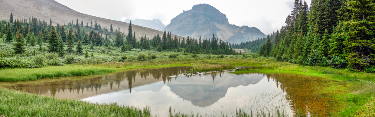
Just below Jonas Pass, we enjoyed my favorite view of the day courtesy of the Wall of Jericho and its rippled reflection in a conveniently placed tarn.
.jpg)
A more panoramic view of the above-mentioned tarn and Biblically referenced mountain. Click to see larger (but don’t walk around seven times, blowing trumpets 🎺).
.jpg)
.jpg)
LEFT: Another Parks Canada facepalm 🤦 after going up and over Jonas Pass: bridges everywhere except where they’re needed… I believe that we counted seven bridges in a 50 meter-or-so span here (despite having just forded and hopped across a half dozen creeks. Sigh.
RIGHT: After descending from Jonas Pass, we enjoyed fine views towards Ptarmigan Peak before the trail merged with the one that we’d followed down from Deception Pass yesterday. This meant that the end of the Skoki Circuit was at hand!
.jpg)
.jpg)
LEFT: 11-km later and back right where we began and stayed all day: at the foot of Skoki Mountain. 🤔
RIGHT: After removing her wet boots, Grandma declared that it was “happy hour.” Beer and comfy chairs happened in short order and all was deemed well in the Skoki world once more. 🍻
.jpg)
The Lodge’s afternoon charcuterie boards were really over the top! After a sufficient supply of ale and cheese/crackers, Grandma declared that “happy hour” was now closed and that it was, in fact, nap time now. And so, she CREAKED and SQUEAKED her way upstairs to our Lodge room for a Skoki siesta. 😂😴
.jpg)
Clearly, I am less intelligent than Grandma and Tamara, who both enjoyed a restful afternoon at the Lodge after our swampy Circuit. Since I don’t do rest, 🙃 I decided that it would be a shame to circumambulate Skoki Mountain and not summit it… Seeking to burn off the residual calories from my decadent breakfast and lunch, I therefore made haste up the peak’s standard route and found myself on its conch shell-topped summit a short and sweaty 🥵 55 minutes later.
.jpg)
A smoky Skoki Mountain panorama for anyone who completes the Skoki Circuit and wonders what the view from On Top looks like. 🙂 Click to see larger.
.jpg)
The other half of that Skoki Mountain summit panorama, featuring the Red Deer Lakes (which looked much less muddy from up here)! Click to see larger.
After enjoying a brief summit stay, I scree’ed my way back down towards the Lodge to enjoy another hearty dinner with my Mom and our new friend/fellow posse member Tamara. With a successful Day 2 in the books, the dinner conversation would, no doubt, revolve upon the most pressing matter at hand: what are we all hiking tomorrow?
.jpg)
.jpg)
.jpg)
.jpg)
.jpg)
.jpg)