As October 2023 approached its midway point, I wistfully noted that hiking season was coming to an end. Nights were now longer than days, the trees were bare, and the “s-word” ❄️ had reappeared in southern Alberta’s weather forecasts. As I lamented, Brianne suggested that I take advantage of a rare free day on our family calendar to attempt one last scramble (before shoulder season transitioned to outright winter). Knowing full well that a mid-October ascent probably wouldn’t be pleasant, 🥶 she also suggested that I find someone other than her to join me 😂 (and insisted that I not go solo following the recent bear tragedy in Banff National Park).
I, therefore, sent a quick message to Matt Clay to see if he’d be interested in an October 15 outing (knowing full-well that the answer was “yes”). After a flurry of IMs, Matt and I “narrowed” our list of prospective peaks to 31 potential targets. 🧐 However, of these, 1 came up over and over again: Mount James Walker in nearby Kananaskis Country. JW had been somewhere midway up my “to do” list for many, many years, and the idea of tackling a 3,000-m peak as a shoulder season objective held additional allure. Plus, if the whole thing turned into a suck-fest, the drive was, at least, short! With unsettled weather forecast, Matt C. and I agreed to hope for the best and left Calgary at 6:30 am.
As we drove down Highway 40, we eagerly anticipated the sunrise around 8:00 am. 🌄 Unfortunately, 8:00 came and went with no sign of the sun. 😬 While the sky brightened somewhat, it only revealed heavy clouds, which engulfed the surrounding mountains and produced a steady downpour. ☔ Facetiously, we joked that conditions were bound to be better above 3,000 meters elevation 😝 and decided to continue.
When we reached the “Sawmill” trailhead, we were encouraged to find that the rain had stopped. As we geared up, we set our optimism levels to “eleven”; Today, was going to be a great day. The weather was going to clear and we were going to be treated to spectacular views. Or so we told ourselves anyways!
.jpg)
From the trailhead, we followed signs for the “Snowdrift” trail, navigating the area’s labyrinth of old logging roads in a generally uphill/northerly direction.
.jpg)
After about 2-km of brisk morning hiking, we reached an unsigned fork in the trail and followed the narrower right-hand branch, which led up into the forested valley between “Mount Chesmill” and “Kent Ridge North.”
.jpg)
The hike up this valley was, initially, pretty dull (except for a run-in with an obese squirrel). At one point, I stopped to take a photo of some grass blades between trees because they were the most scenic thing that we saw for the first 3.5-km. 🤦♂️ I’ll spare you this photo and your imagination will just have to run wild wondering how pretty this grass must have been. Eventually, we reached a small clearing where views towards “Mount Chesmill” provided a more justifiable excuse to stop.
.jpg)
Continuing up-valley, we had ample time to scan “Mount Chesmill’s” slopes (as there was little else to see) and were excited to discover a family of mountain goats going about their morning routine, high above. This served to reassure me that today was going to be a great day because, well, GOATS!!!🐐
.jpg)
Further along our approach, the forest briefly became a boulder field (filled with barren larch trees) and we were treated to our first views of Mount James Walker ahead (center left).
.jpg)
Where once a lake dwelled… Sensing the changing of the seasons, this usually scenic tarn obviously migrated; perhaps south, but more likely east towards the Atlantic Ocean. 😏
.jpg)
.jpg)
LEFT: Normally, hikers have to walk all the way around this tarn but, oh no, not today! Matt C. and I saved ourselves at least 0.1-km by ambling straight through its muddy remnants. Winning!
RIGHT: Hmmm, looks like we weren’t the only ones keen to save a little distance/time… Yo Bear! 🐻
.jpg)
Upstream of the mud formerly known as tarn, we eventually found actual water in the form of a charming little creek, which cascaded forth from a small canyon. Here, we followed the trail as it ventured back into the woods above the canyon on its right side.
.jpg)
Soon, we encountered the defender of the canyon, who showed no fear as we entered his realm. This was fine because this gave us plenty of time to snap some photos of him. At one point, Matt C. was down on the ground with him trying to get a better shot and I jocularly noted that he may have met his intellectual match. 😝 Again, it was a pretty boring approach, so we needed to find ways to amuse ourselves.
.jpg)
.jpg)
LEFT: Eventually, the forest dwindled again and we discovered a spring, which appeared to pour forth from a cave! While this cave was slightly out of the way, I figured that it merited a side-trip and quickly scrambled up to it.
RIGHT: Unfortunately, the cave/spring were relatively underwhelming when seen up close… 😔
.jpg)
Continuing up out of the forest, we entered a vast alpine meadow at the intersection of the valleys between “Headwall Peak” (left), Mount James Walker (center) and Mount Inflexible (right). While JW can be tackled head-on via the moderate slopes visible here, we elected to follow the right-hand valley to its end, where an easier route up can be found. As the clouds continued to boil and swirl above, “sucker holes” of blue sky kept us optimistic RE: our chances of actually seeing something from the summit! 🤞 Click to see larger.
.jpg)
This vast alpine expanse was very clearly the realm of a grizzly bear and Matt C. mused that some of the diggings we found were not especially old. 🤔 Again, after the recent tragedy in Banff NP, this had us a little more on-edge than usual but bears literally come with the territory out here, so we continued (loudly) up the valley…
.jpg)
… And what a pretty alpine valley it was! 😍
.jpg)
Better still, the valley was filled with coral fossils! On descent, Matt C. and I would spend quite a bit of time nerding out 🤓 here but, for now, we had a mountain to climb! Up and at them!
.jpg)
.jpg)
LEFT and RIGHT: Further up valley, we discovered a series of scenic tarns. Stopping to take some quick pics, we briefly “Oohed” and “Aaahed” until we got chilled and decided to carry on. 🤷♂️
.jpg)
Looking back down our scenic ascent valley, we suspected that there were mountains somewhere above in those clouds and remained optimistic that we’d even see a few of them today!
.jpg)
At the head of the valley, the pleasant meadow literally ran out and we were left with nothing but gray scree, which we followed up and to the climber’s left towards an unseen col.
.jpg)
Matt C. slowly moseys up and left towards the col, taking advantage of grassy slopes when they were available. At this point, we both noted that we were atypically lethargic. Seasonal affective disorder on a gray day, perhaps? Nevertheless, we continued up, and up, and up (albeit slowly).
.jpg)
Above the last of the grass, we actually found a good trail through the scree up to the col. As we neared it, JW’s brooding summit slopes finally came into view ahead on the left…
.jpg)
Hiking up gray scree under gray skies, we eventually got high enough to catch a cloudy glimpse of the Opal Range beyond the more proximate connecting ridge to Mount Inflexible.
.jpg)
.jpg)
LEFT: As we prepared to tackle the final 400 vertical meters to the summit, Matt C. remained naively happy. Having scrambled up JW once before, he really should have known better! 😂
RIGHT: A little over 400 vertical meters of increasingly steep, windswept, frozen scree. Ain’t gonna climb itself… 😖
.jpg)
As we tackled this final slope (which was objectively miserable), we eventually encountered JW’s sheer northeast face. While the drop from this face was precipitous, it did grant pleasant views of the Kananaskis Valley, nestled below a low cloud ceiling. Click to see larger.
.jpg)
About an hour after we started our summit push, we reached JW’s apex and marveled at the sheer drops all around it. While our ascent route hadn’t been pleasant, we certainly wouldn’t have enjoyed any of the alternatives more!
.jpg)
.jpg)
LEFT: For views like this, all of the suffering, slipping and cold were worth it though!
RIGHT: At least, the visibility was good enough to see the summit register! Given the peak’s relative ease and proximity to Calgary, it was surprising to find such old ascent records still buried within its frozen summit cairn!
.jpg)
Mount James Walker is 3,035-m-tall and, on this day, the cloud level was, more or less, 3,035-m. So much for the spectacular views that we’d promised ourselves at the hike’s outset! 😂 Ah well, a gloomy weather day in the mountains is still a good day and it’s not every October 15th that you can sit atop a 3000-m-tall peak and bitch about the weather! Click to bitch see larger.
.jpg)
From the summit, we could see the right-hand branch of the westerly valley which we did not ascent and noted that it also featured some potentially scenic tarns. Of course, we’d have loved to have looked above the valley bottoms, but there wasn’t much to see there today!
.jpg)
Cold and cloudy Kananaskis Range peaks to the northwest…
.jpg)
Clouds swirling around JW’s NW ridge.
.jpg)
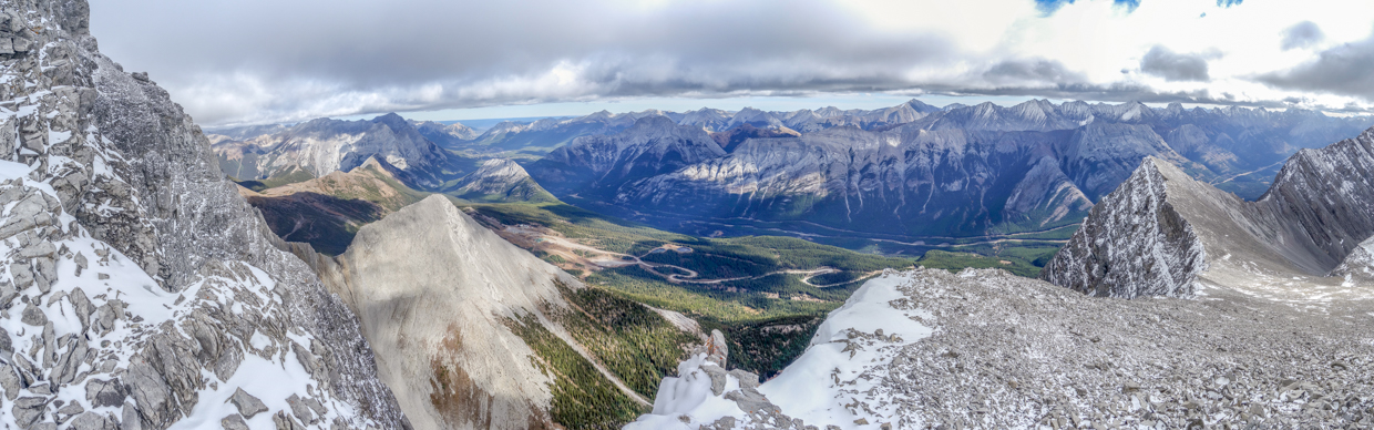
An overcast panorama north and east, over the derelict Fortress Ski area, towards the sunnier Kananaskis Valley. Despite waiting atop the chilly summit for 35-minutes, there was no significant clearing and this view was, pretty much, the best one that we got. Click to see larger and imagine having really cold hands and feet for this view. 🥶
.jpg)
Yours truly about to be engulfed in cloud.
.jpg)
Looking back down our non-technical ascent slopes and catching panoramic glimpses of the Opal Range to the east. Click to see larger.
.jpg)
The Wedge (left) and Opal Ridge (right) were among the peaks we could actually distinguish on this day!
.jpg)
Ah well, the sun can’t shine every day! After a chilly 35-minutes atop Mount James Walker, we picked an apt background ☁️ for our group summit selfie and packed up to head down!
.jpg)
While the peak’s southeast slopes are completely non-technical, they are deceptively steep and with frozen scree and wind-polished sn’ice, descending them wasn’t trivial. Mercifully, the cold had numbed our butts, so they didn’t hurt when we fell on them.
.jpg)
Below the steepest summit slopes, Numb-Butt 😝 Matt C. enjoys the scenic and easier trail down through the scree towards the base of Mount Inflexible.
.jpg)
When we reached the valley, its soft (but narrow) grass carpet was most welcome underfoot after several hours on frozen scree!
.jpg)
Once we were well down the peak, the sun finally managed to break through the persistent clouds that haunted our hike. ⛅ Ideally, this would have come to pass an hour or two earlier but that’s not usually how climbing mountains works…
.jpg)
.jpg)
LEFT: The now-sun-splashed tarns in the descent valley proved even more scenic than they had in the morning’s flat light.
RIGHT: Following a pleasant mixture of karst pavement and alpine meadows down towards the intersection of the valleys on the east and west sides of James Walker. Below this point, the merged valleys continue down towards the still-distant trailhead.
.jpg)
Matt C. pauses to enjoy sunnier skies, as we continue our descent past the mud formerly known as tarn.
.jpg)
.jpg)
LEFT: While we mostly made haste during our 9.5-km descent, we stopped now and then to enjoy the little things (like this mossy canyon) before resuming our hike out.
RIGHT: ♫ Blue skies, smiling at me; Nothing but blue skies, do I see! ♫ 😂🤦♂️
In the end, our mid-October ascent of a 3000-m peak proved about as enjoyable as expected. Views or no views, and with or without feeling in our fingers and toes, it was still great to get out with Matt C. for one last “big one” before our long Canadian winter truly settles in… 🥶🌨️⛄
.jpg)
.jpg)
.jpg)
.jpg)
.jpg)