Wapta Falls
Elevation: 1080 m
Elevation Gain: 125 m
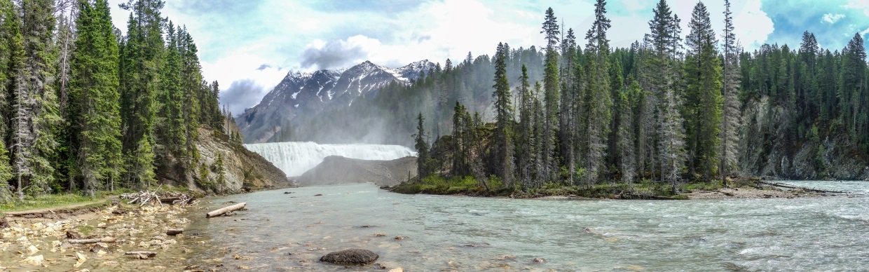
With a height of 18 m and a width of 107 m, Wapta Falls is the Kickinghorse River’s largest waterfall. “Wapta” is the Stoney term for “running water” which is apt given the falls’ average flow of up to 96,000 liters per second.
My Ascents:
June 10 2021
Trailhead: Wapta Falls Trailhead
After 8 pandemic-filled months apart, Brianne, the girls and I finally decided to brave interprovincial travel to visit her sister on her acreage in Armstrong, BC. Recreational travel was still officially frowned upon but, with our girls quickly growing up, we decided that a long weekend with “Auntie” qualified as “essential” for them! Of course, the drive would bring us over both the Canadian Rockies and the Purcell Mountains, offering plenty of opportune places to “stretch our legs” (read: hike). During previous commutes along this stretch of highway, I’d noted that Wapta Falls looked like a nice outing but, with a camping trailer usually in tow, its petite parking area always deterred me. Without our well-travelled trailer, this trip provided the perfect opportunity to break up the 6-hour drive with a little mountain air!
.jpg)
And we’re off! After being cooped up in their car seats for 3 hours, Mera and Penny made quick work of the, initially, arrow-straight trail, sprinting towards our detour destination.
.jpg)
The trail maintenance crew had obviously put their chainsaw to good use in some areas…
.jpg)
.jpg)
LEFT: … But they missed at least one! 🤣
RIGHT: As the roar of the falls grew louder, fences popped up to keep small children and idiots away from steep upstream terrain.
.jpg)
Impressive views west beyond the fences (possibly Coral Mountain).
.jpg)
As the trail began to descend towards the falls, it forked. The left-hand branch proved steeper but passed an impressive overlook. The right-hand branch was much gentler but provided no glimpse of the falls until the hike’s terminus downstream of them. Both trails meet up at that point so we went down the steep trail and completed our little loop by coming up the other way.
.jpg)
A spectacular scene from the steeper trail’s overlook! These falls are as wide as a Canadian (real) Football field!
.jpg)
As the trail wound its way downstream, the falls began to disappear beyond a monstrous rock pile. At one time, this pile was the lip of the falls but erosion of softer rock upstream eventually saw the falls migrate backwards, leaving a more resistant rock rib where they once plunged downwards. Fortunately, the fine views of the Chancellor massif above more than compensated.
.jpg)
.jpg)
LEFT: The picturesque scene downstream of the falls could have been painted. Hell, there were even paintbrushes! 🎨
RIGHT: Riverside refreshments for our little ones.
.jpg)
With the 2.5 km return hike and a 4 hour-drive still ahead of us, we decided we’d best get back underway after a brief repast in the cascades’ swirling mists…
.jpg)
.jpg)
LEFT: But not before a quick (and colorful) family selfie!
RIGHT: They may look sweet now but you sure wouldn’t want to spend the next 4 hours stuck in a car with them! (At least, we knew we’d have “backup” at the end of our long day’s journey) …