Toe of the Athabasca Glacier
Elevation: 2035 m
Elevation Gain: 60 m
The Athabasca Glacier is one of eight tributary glaciers which flow down from the Columbia Icefield. The icefield is one of the largest accumulations of ice and snow south of the Arctic Circle, covering 325 square kilometers and ranging in depth from 100 to 360 meters. The icefield is located atop the hydrological apex of North America and its melt waters flow into 3 different oceans (Pacific, Arctic and Atlantic). Although the sheer volume of ice stored within the icefield is difficult to comprehend, it is rapidly shrinking as a consequence of climate change. In the past 125 years, the Athabasca Glacier has receded by over 1.5 km and has lost half of its volume. The name “Athabasca” is derived from a Cree word meaning “where there are reeds.” This word was first used by fur-traders to describe northeast Alberta’s Athabasca Lake and ultimately found its way to the lake’s source in 1898.
My Ascents:
August 18 2021
Trailhead: Toe of the Athabasca Glacier Trailhead
All good things, as they say, must come to an end. After an eventful hike-full 4-night family camping trip in Jasper, the time came to pack up our site and brave the 5-hour drive home with our kids. Road trips with young children can range from “bearable” to “hell on Earth” so to maximize the likelihood of this drive being the former, we planned a couple of stops to let the kids burn off steam. Since the spectacular Columbia Icefield was on our way home, we figured that the small 1.4-km hike to and from the toe of the mighty Athabasca Glacier would make for a good first stop. In fact, we’d planned to stop here on our drive to Jasper days earlier but aborted our attempt when the kids stopped cooperating, a Goat wouldn’t cross a road and a full-on domestic broke out. Having been cooped up in the car together for only an hour on the way home, we all arrived at the trailhead in much better spirits this time! 🙃
.JPG)
.JPG)
LEFT: Brianne, Penny and Mera pose on a bridge at the trailhead. Beyond them, the busy trail travels a short distance up glacial debris towards the (unseen from here) Athabasca Glacier.
RIGHT: Mount Kitchener is one of several 11,000ers visible from the small bridge at the trailhead.
.JPG)
.JPG)
LEFT: 5-year-old Mera gives 3-year-old Penny a hand as they follow “the path of the Glacier” (passing year markers that serve as a depressing reminder of the impact that human-caused climate change has had on this landscape 😔).
RIGHT: It seems that we’re raising a pair of posers. Who needs a fan for that coveted “windblown hair” look when there’s an icefield to generate katabatic winds nearby?
.JPG)
Penny proves (once again) that even the simplest hike can be scrambling if you try hard enough! 🤦♂️
.JPG)
Brianne stops to take in “The Big Picture” from a plateau that grants magnificent views towards the Athabasca Glacier’s toe.
.JPG)
The awesome Athabasca Glacier plunges 800 vertical meters down from the much larger Columbia Icefield above.
.JPG)
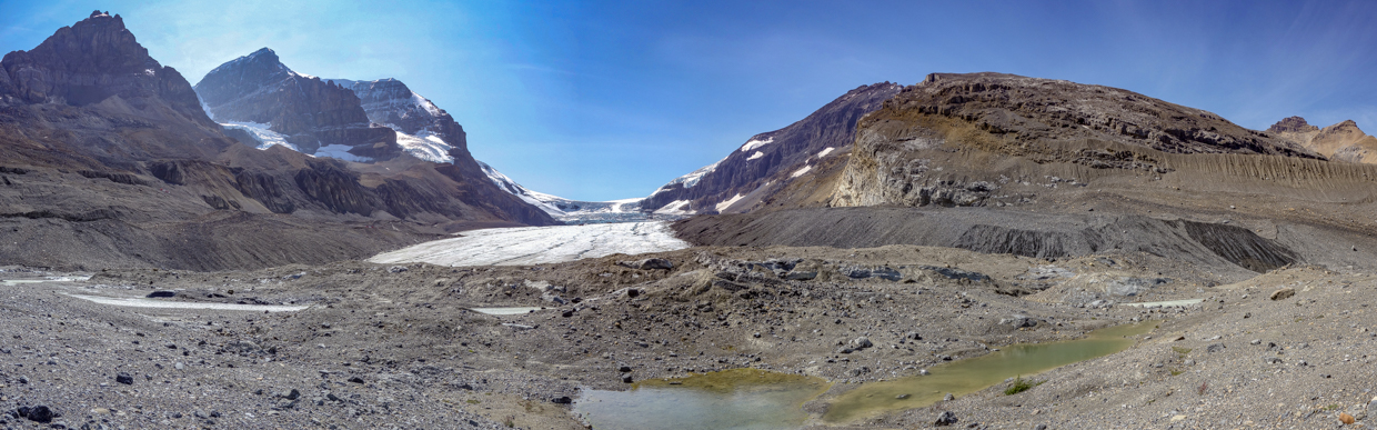
The glacial panorama from the trail’s end (click to see larger). While the hike may, at one point, have ventured as far as the Glacier’s actual toe, it now stops well-short as the likely result of glacial recession and Parks Canada safety concerns. The hike’s terminus is well-marked with ropes, pylons and signs and those who are not familiar with/equipped for glacier travel are advised to respect them.
.JPG)
A pair of snowcoaches navigate the Athabasca Glacier’s lateral moraine at the feet of Mounts Athabasca and Andromeda (another pair of 11,00ers). These tourist-oriented buses provide a great experience for visitors but my confidence in them was completely eroded by a horrific 2020 accident that left 3 passenger dead. I’ve enjoyed previous rides on these monster-buses but, going forward, I’ll leave my Athabasca Glacier explorations to certified guides who provide a more earnest glacier experience.
.JPG)
.JPG)
LEFT: A closer look at Mount Andromeda and its spectacularly broken hanging glacier.
RIGHT: Mera and Penny enjoy the scenery and company on a beautiful sunny day. It was a pity that we had to get back in the car to complete the 4-hour drive home after this!
.JPG)
A telephoto towards the snowcoach-transported tourists on the glacier. Above the snowcoach area, several of the Glacier’s icefalls make it obvious why the buses stop where they do!
.JPG)
.JPG)
LEFT: A pair of tourons who decided that the many warning signs didn’t apply to them. “Hi friend – can you please take a pic of me falling into a crevasse for my Instagram account?” 🙄
RIGHT: A series of seracs hang precariously above the Athabasca Glacier on the flanks of Snowdome (another 11,000er).
.JPG)
Those darned katabatic winds wreak havoc with our family selfie at the “Toe” of the Glacier. Ah well, at least my hair still looks fine! 🤣
.JPG)
After admiring the Glacier for a few minutes and taking some photos, Mera, Penny and Brianne took off to complete the remainder of the hike which briefly looped around the nearby moonscape before returning to the trailhead. While the views in this direction were less spectacular, they did highlight the monstrous size of the Athabasca Glacier’s lateral moraines (the striated pile of rocky debris above the crowd in this photo). These moraines were piled up by the Glacier during the height of its most recent advance in 1844. That is to say that the Glacier was as deep as that pile of rocks back then. Sadly, its estimated that the glacier is currently losing 5 m of depth per year and that loss appears to be accelerating. All good things, as they say, must come to an end and I fear that the end of the Rocky Mountain glaciers is rapidly approaching…
.JPG)
The nascent Athabasca River mirrors the Glacier’s form as it begins its long journey towards Athabasca Lake (some 1,231 km away) and, eventually, the Arctic Ocean.
.JPG)
Massive lateral moraines bookend the rubble field that the Athabasca Glacier’s recession has left in its wake. The trees visible in the distance show how far the Glacier reached as recently as the mid-19th-century.
.JPG)
Snow-dusted Tangle Ridge (left) and glacier-carved Wilcox Peak (center right) tower above nearby Sunwapta Lake.
.JPG)
Nearby Nigel Peak also sported a dusting of fresh (mid-August) snow.
.JPG)
Making our way back to the popular trailhead amidst a steady flow of tourists and sightseers.
.JPG)
Improved views of Snowdome (left), Mount Kitchener (right) and the impressive icefall between them from the nearby Icefields Center (where we’d parked our camping trailer for fear that it wouldn’t fit in the trailhead parking lot). After loading everybody back up, we bid adieu to the spectacular Columbia Icefield and resumed our, still lengthy, 4-hour drive home.
.jpg)
.jpg)
LEFT: Of course, 4-hours of driving in one shot is a pretty tall order with 2 young children in tow. We, therefore, stopped in Banff to let them run off even more steam (lest the drive degenerate to “hell on Earth” status).
RIGHT: Rest stops aren’t the only way to make travelling with young children bearable 🍺! After a quick run down Bear Avenue and a pint/meal at the new Three Bears Brewery, we hit the road again to complete the final leg of our drive home from Jasper. All good things, as they say…
.JPG)