After an enjoyable cycling adventure on Banff National Park’s Legacy trail a few weeks earlier, we decided to tackle another Bow Valley spin. With a seasonal closure to motorists in effect, the Bow Valley Parkway (BVP) is a no-brainer Banff bike ride and had been on our bucket-list for a few years. In fact, we almost tackled it 2-weeks earlier but deemed its 36-km return distance to be “too long” to do with our kids. Instead, we took on the 45-km Legacy Trail, essentially, by accident. Armed with the knowledge that we could bike that distance as a family, the 36-km ride to Johnston’s Canyon from Banff and back suddenly seemed more reasonable! In fact, we figured that a mere 36-km might prove too easy and decided to tack on a small hike for good measure. How could we bike 18-km to Johnston’s Creek without exploring its popular namesake Canyon (at least a little)?
.JPG)
After a leisurely morning watching the local elk forage at Banff’s Tunnel Mountain Village I campground, we loaded our bikes onto their rack (with great difficulty) and made our way west towards the BVP. Side note: views like this are why Village I is INIFINITELY preferable to its neighboring campground Village II (avoid at all costs).
While the Parks Canada website lists the Fenlands Rec Center or Banff train station as preferred parking spots for the BVP, these add 6.5-km distance to the day in each direction. As a result, we elected to park right at the BVP’s eastern end where the road is closed to vehicles. Based on the number of cars that parked alongside us here, it seems that few are keen to park in the town of Banff as advised.
.JPG)
Ready – Set – Go! Brianne and 5-year-old Mera set off for our day’s BVP bike ride.
.JPG)
After a couple of kms of leisurely road cycling, we stopped at a pullout to see the smoky Bow Valley sights (the Sundance Range at left and Mount Bourgeau at right). I’ve driven along the BVP dozens of times but this was the first time that I stopped to enjoy the view from any of the road’s many lookouts. Another benefit of cycling the BVP: pullouts are a break instead of a delay!
.JPG)
.JPG)
LEFT: Mera enjoys the first of many Parks Canada signs teaching her about the nature all around her. Who wouldn’t want to learn about backswamps?!
RIGHT: A bald eagle watches on from above the backswamp. The BVP is a significant wildlife corridor and, based on the amount of bear scat that we found on the road, the animals like it almost as much as cyclists do. 🐻💩
.JPG)
Back on our bikes, we resumed our journey, passing under one of Mount Cory’s impressive outliers.
.JPG)
.JPG)
LEFT: Pilot Mountain towers across the Bow Valley while Mera and her Mom quickly disappear down one of the road’s many downhill sections. Unfortunately, these would become uphill sections on the way back!
RIGHT: Getting ready for another speedy downhill section.
.JPG)
An interesting peak (unofficially called “the Finger”) makes for a scenic backdrop to the Sawback burn. The Sawback Range has been the site of repeated prescribed burns (1985, 1986, 1993, 1998 and 2014) intended to reintroduce fire to the Banff National Park ecosystem after decades of suppression. These burns not only opened up views like this but they also opened up habitat for a number of plants and animals.
.JPG)
.JPG)
LEFT: A flower-filled view towards Bow Valley landmark Pilot Mountain.
RIGHT: A BVP peculiarity – a large tree in the middle of the road (but is it a magical, talking whitebark pine? 🤯).
.JPG)
Cruising through montane meadows at the foot of magnificent Mount Ishbel.
.JPG)
.JPG)
LEFT: As we neared Johnston’s Canyon, a terrible thing happened. The highway split into separate eastbound and westbound lanes and the westbound road went STRAIGHT uphill. It may not look like much in this photo but this section had us huffing and puffing in our lowest gear for a long, long time!
RIGHT: Seeking to shed weight on the steep uphill, Brianne (faintly visible in the distance) let Mera off her tag-along bike. While Brianne continued to cycle struggle up the road, Mera made things look easy by sprinting straight up. In a word, her energy is BOUNDLESS.
.JPG)
.JPG)
LEFT: What goes up, must eventually come down (at BREAKNECK SPEED, no less). As we crested the monstrous uphill, we were greeted by a downhill so long and steep that we couldn’t see its end. Allowing gravity to do its thing, we accelerated furiously (daring not to brake or turn for fear that our bikes would fly apart). As you can see from my GPS, we set (what I believe to be) a land speed record for a bike towing a 3-year-old in a Chariot (62.7 km/hour)!
RIGHT: Shortly after the formidable downhill, a sign heralded our arrival at Johnston’s Canyon.
.JPG)
After parking our bikes, we set off on foot towards the popular Johnston’s Canyon hike. As you can see, its bridge and many catwalks proved to be a hit with our little ones.
.JPG)
Stopping for a quick bite to eat before proceeding up the canyon in earnest.
.JPG)
.JPG)
LEFT: Mera consults a sign for directions (only she can’t read yet).
RIGHT: For reasons that were not immediately obvious, Mera insisted that I take a photo of her with this tree. Once it was taken, however, she ran off and never asked to see it again.
.JPG)
.JPG)
LEFT: Although the popular trail featured a wide, paved path, our children insisted on following the “balance beam” alongside it for as long as they could.
RIGHT: Eventually, the retaining wall/balance beam deteriorated and the children were “forced” to “scramble.”
.JPG)
.JPG)
LEFT: As we continued up alongside Johnston’s Creek, the canyon walls quickly became more formidable.
RIGHT: Mera leads the charge up the first of many catwalks that cling to the canyon’s sheer walls.
.JPG)
.JPG)
LEFT: You never know who you’ll run into on a popular hike! As the girls took a potty break in the woods, Brianne enjoyed a rest on a bench. Moments later, her Uncle Odo sat next to her (initially unaware that he’d sat next to his niece). As he struck up a conversation with the “stranger” next to him, they both did a quick double-take. Once the girls completed their “business”, we returned and were thrilled; the girls because they love their Great Uncle Odo and me because he was staying in one of the cabins below and offered us a beer! Cheers Odo! 🍻
RIGHT: While Brianne and I caught up with Odo (something to the effect of “What the hell are you doing here?!”), the girls busied themselves climbing whatever they could find nearby.
.JPG)
.JPG)
After a brief chat, we parted ways with Uncle Odo. He was on his way down and we still had more canyon (LEFT and RIGHT) to explore!
Moments after leaving Odo, we ran into his wife (Brianne's Aunt Donalee) and her family (including Mera's favorite second-cousin). What started as a bike-and-hike was quickly turning into a family reunion! After, again, catching up, we parted ways (for now) and resumed course upstream.
.JPG)
Mera and Penny “do their little turn on (another) catwalk.”
.JPG)
.JPG)
LEFT: After just over a km on the popular trail, we reached the spectacular Lower Falls.
RIGHT: Unfortunately, we weren’t the only ones at the Lower Falls. As you can see, there was quite a queue to get up close and personal with them (we didn’t bother)! Since we still had an 18-km bike ride ahead of us and knew there was a cold beer waiting for us in Odo’s cabin below, we decided that the Lower Falls were as good a spot to turn around as any and did just that.
.JPG)
Making our way back down along the catwalks.
.JPG)
Pausing for a quick photo of my girls in the canyon (which was only spoiled somewhat by Penny throwing an epic tantrum for no reason).
.JPG)
After enjoying a cold beer with Uncle Odo, Aunt Donalee etal. at the base of Johnston’s Canyon, we reluctantly climbed onto our bikes and started back east towards our car, some 18-km away. As we embarked on our return journey, we were acutely aware that the hill which we’d furiously sped down needed to be ascended in this direction…
.JPG)
Winding our way up yet another hill. Fear not – we were in no danger of exceeding the posted speed limit at this point! 🤣
.JPG)
Mera and Brianne continue to pedal as a “local” watches on.
.JPG)
Bah Ram Ewe!
.JPG)
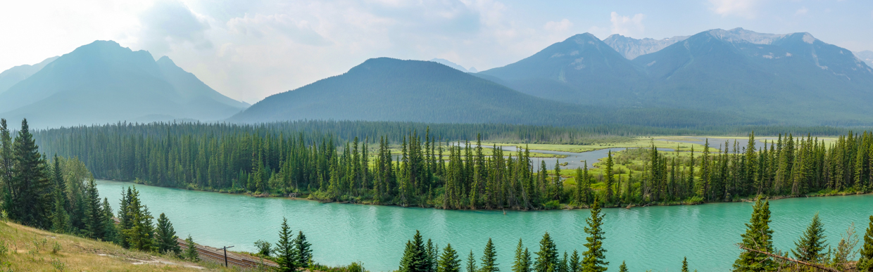
Stopping to admire the view of the Bow River’s cerulean waters – there’s definitely some glacial silt left at this point in the river’s journey towards the Atlantic Ocean!
.JPG)
BVP Beauties (looking a little more tired than when we first set out earlier in the day).
.JPG)
Brianne and Mera coast back to the car (running on fumes) after another eventful day. 39-km after we started, we finished. At least it wasn’t the 45-km Legacy Trail this time! 🤣
.JPG)
While our BVP bike ride proved exhausting, we were fortunate that our Village I campground was only a few minutes away. Better still, the ice cream in our trailer’s freezer was still frozen, allowing us to refuel for our next mountain adventure… 🍨