At some point during Brianne and I’s seven years (and counting) of marriage, our wedding anniversary came to be associated with climbing a mountain (how’d that happen?!). While Brianne has mentioned, from time to time, that there is more to marriage (and life) than mountains, I am a hopeless peak-bagger. So as our September 14 anniversary approached, I began to dream of summits for us to celebrate atop together.
With COVID-19 still wreaking havoc on normal life, our anniversary routine changed somewhat this year. Instead of staying overnight at Lake Louise’s, usually full, Deer Lodge, we decided to spend the weekend on our own in our beloved camping trailer. Having just camped in Lake Louise, we also decided to explore a new area and booked ourselves a spot at Kootenay National Park’s Redstreak campground. Of course, a new area meant new mountains (for me anyways) and I became extremely excited at the prospect of taking Brianne up a remote peak in the BC backcountry! Indeed, Redstreak’s proximity to various BC Forestry Service Roads proved especially enticing. Afterall, what woman wouldn’t want to be whisked 50 km up a rough logging road for her anniversary?
.jpg)
After working from home on Friday, we left our kids with their Nannie and Papa (THANKS!!!) and completed the drive to Redstreak where we set up camp for the weekend. As you can see, camping really isn’t “roughing it” for us anymore! Unfortunately, we had an unusually poor sleep as wildfire smoke rolled in during the night, causing allergies to go into overdrive.
.jpg)
Despite the poor night’s sleep, we still managed to get ourselves out of bed on Saturday morning and navigated a series of FSRs to reach the base of our intended target: White Man Mountain. WM has been high on my to-do list ever since Andrew Nugara posted stunning photos from its east peak in 2008. Since then, Matt Clay also climbed WME with his wife, confirming that it was a suitable peak for spouses. After completing a delicate 10-point turn just before a road washout, we parked and set forth on our 2020 anniversary adventure!
.jpg)
Brianne enjoys easy travel and spectacular, but hazy, views along the FSR beyond the washout.
.jpg)
With a massive headwall ahead, we took advantage of a clear-cut to begin gaining elevation on more passable slopes as the morning sun attempted to break through the wildfire smoke.
.jpg)
.jpg)
LEFT: A few weeks prior to our anniversary, a “little birdy” informed me of a trail in the area that could be used to grant bushwhack-free access to White Man Mountain. Happily, we found the trail and put it to good use! This trail is used by the operators of a nearby backcountry lodge. Out of respect for said lodge and its guests, I’ve decided to keep the details in this trip report vague. Hence, it will feature no detailed route description nor will it include a GPS track.
RIGHT: The trail was both well-maintained and well-marked with blazes. As you can see from this photo, some of those blazes were happier than others! 🤣
.jpg)
After an hour in the forest, we followed the trail into a subalpine cirque where Brianne managed to enrage a nest full of wasps who decided that I was the one who should be stung! 😒
.jpg)
Brianne follows the lovely trail as it meanders cleverly back-and-forth on ledges to overcome the massive headwall below White Man Mountain.
.jpg)
Atop the headwall, we discovered a pristine alpine plateau replete with colorful larch trees in their full autumn glory. White Man Mountain’s west (center left) and east (center) peaks were also laid out for our evaluation at last. While the west peak is White Man’s true summit, it reportedly requires ropes while the marginally lower east peak is walk-up. Unfortunately, said walk goes up the right-hand skyline ridge which looked further away in person than it had when I planned the route out on topo maps! Click to see larger.
.jpg)
In an effort to avoid unnecessary ups and downs, we contoured along wide ledges as we made our way towards the larch-filled meadows at the base of WME (left side of the above photo).
.jpg)
A different angle reveals why those who have climbed WME (right) don’t continue to the true summit (center left).
.jpg)
A closer look at the traverse between the true (center) and east summits of White Man Mountain. The ridge top route is most certainly a no-go but it looks like a scree ledge traverse below could be feasible (if not unduly spicy).
.jpg)
Brianne makes her way across alpine terrain, aiming for the low point of WME’s ascent ridge at right. While topo maps and satellite imagery made these environs looks like gentle alpine meadows, we discovered that they were, in fact, made up of dozens of rocky ledges. These ledges were not difficult to navigate around; a combination of off-trail hiking and easy scrambling was always sufficient. They did, however, have the nasty habit of angling us away from where we were attempting to go! Their cumulative up-downs also started to add up as we made our way over to WME. As a result, the distance and elevation gain across, what was supposed to be a flat meadow, proved larger than anticipated.
.jpg)
Alpine plateaus make for lovely grizzly bear habitat! Not sure if this was a den or the result of an overzealous bruin trying to dig out a marmot… Either way, “Yo Bear!”
.jpg)
As we finally neared the ascent ridge, we spotted several cairns and a faint path through the scree, suggesting that the nearby backcountry lodge brings some of their guests up WME.
.jpg)
Mount Sir Douglas makes an impressive appearance beyond more proximate Mount Leman as we follow the scree path up towards WME’s ascent ridge.
.jpg)
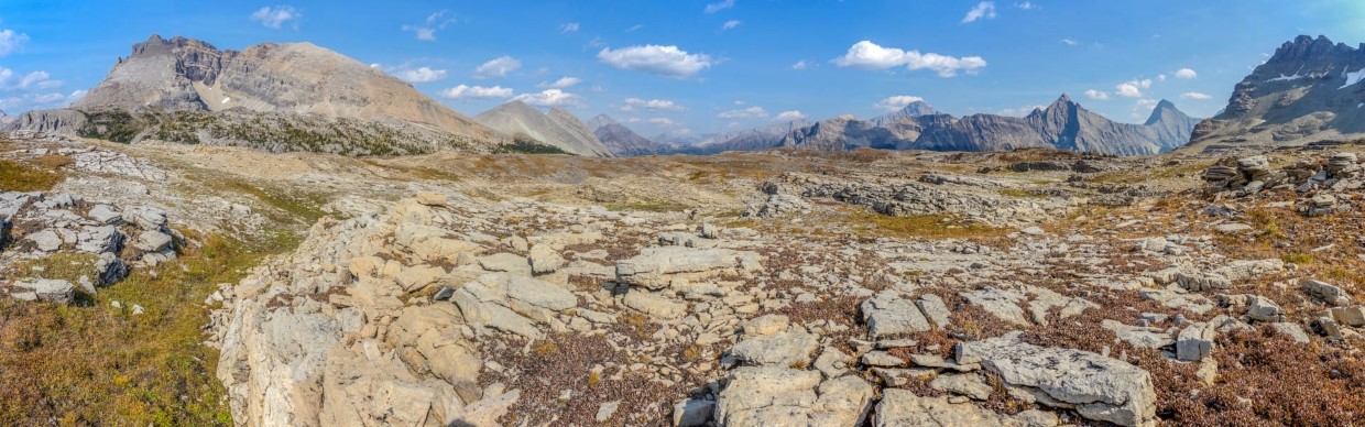
Upon gaining the ascent ridge, a smoky but spectacular panorama unfolded before us. Click to see larger.
.jpg)
From the ascent ridge, Leman Lake was visible at the foot of its namesake mountain. Beyond the lake and peak, Burstall Pass and Burstall Pass Peak were also visible. Beyond the pass and peak, familiar Kananaskis landmarks like Mount Chester (left), Whistling Rock Ridge (center), Mount Murray (center right) and Mount Sir Douglas were also visible. One of the funny things about hiking in this area is the fact that it takes nearly 4 hours to drive here and, when you arrive, you’re not far (as the crow flies) from peaks that are only a 1.5 hour drive from Calgary! Nevertheless, the views and lack of Calgary crowds more than justify the extra drive (in my opinion, anyways).
.jpg)
Massive Mount Sir Douglas is one of the many 11,000ers near White Man Mountain.
.jpg)
Peaks rear impossibly skyward above the Albert River Valley to the southwest.
.jpg)
Incredible rock-folding on Mounts Queen Elizabeth (left), King Albert (center left), Back (center right) and Craddock (right).
.jpg)
The hazy heart of the Royal Group appears as a smoky silhouette beyond Lockwood Peak. Mount Prince John is the eye-catcher at right.
.jpg)
Apart from blocky talus, the ascent ridge looked straightforward. What the picture doesn’t show, however, is the gale force wind which constantly threatened to knock us off of our feet on this unstable terrain. On the upside, the wind cleared away the heaviest of the smoke which plagued our ascent and our night’s sleep prior to that. On the downside, it was vexing and cold. With the knowledge that the summit was still 460 vertical meters above us, we stopped to discuss the merits of continuing up vs. turning back. In addition to the factors above, Brianne wasn’t exactly “feeling this one” after sleeping very poorly the night prior. We also knew that we had a long hike back over the ledge-filled alpine plateau below and then a slow drive back to Redstreak on FSRs. If there was going to be anything to our anniversary celebration except for remote hiking, we’d need to turn back…
.jpg)
Agreeing that there’s more to life than summits, we made the difficult decision to turn back. During our discussion, Brianne offered to wait on the windy ridge while I tackled the peak as quickly as possible. That offer was tempting (so much so that I actually readied myself to depart at one point) but, in the end, I couldn’t justify separating. I want White Man Mountain. But I want my wife more and today was our anniversary. I love standing atop mountains with her but the time spent together on those mountains has always been more important than reaching their apexes. Not making the summit might gnaw at me a little but leaving my wife on our anniversary would have made it difficult for me to look in the mirror.
I can be a bit pouty when I don’t get to the summit I’ve targeted but, on this day, the vast alpine plateau at the foot of White Man Mountain was so stunning that I chose to enjoy it rather than dwelling on the summit that got away. Ironically, Brianne (who is also goal-oriented) seemed more upset by our turnaround than I was!
.jpg)
.jpg)
LEFT: If either of us was disappointed about turning around early, that disappointment quickly washed away amidst the alpine splendor that surrounded us.
RIGHT: Brianne makes her way across the alpine plateau towards eye-catching Sharkfin Peak. Having cut our ascent short, we decided to explore the spectacular alpine plateau for a bit before meandering back to "our" secret trail. Now that we didn’t have to grovel up nearly 500 vertical meters of talus, there was a little extra time for scenic wanderings.
.jpg)
As we worked our way towards the high point of the plateau, we were gobsmacked by the spectacular panorama west towards where we’d originally hiked in. Click to see larger.
.jpg)
Rarely ascended peaks (and one pretty popular one) highlighted the view to the west. From left to right: Mount Alcantara, Eon Mountain, Mount Assiniboine and Red Man Mountain.
.jpg)
A closer look at Red Man Mountain’s colorful summit.
.jpg)
Of course, the southward panorama from the plateau wasn’t exactly “chopped liver.” Click to see larger.
.jpg)
The prettiest part of the view! 😍 After the difficult decision to turn around on WME, it was great to see my love smiling again (she was a bit surly at first 🤣)!
.jpg)
Geologic faulting along the plateau created a mixture of black and orange rock that enhanced the view towards Mount King Albert’s impossibly sharp summit.
.jpg)
A striking, but unnamed, 3-summited peak on the plateau’s southern edge.
.jpg)
Are we there yet? Every time that we climbed a small ledge thinking that we would pop out on top of the plateau, a new ledge seemed to appear above! All told, we ended up wandering 1.5 km off of our ascent path in our attempt to reach the plateau’s high point.
.jpg)
Of course, some views are worth hiking a bit further for! As we topped out on the plateau, we were greeted by a wonderful panorama which included alpine meadows, golden larch trees, glimmering tarns and sheer Sharkfin Peak. Click to see larger.
.jpg)
Sometimes it’s the small things… With grand views all around, it’s surprising that the spring in the foreground stood out as such a highlight! This amazing little creek bubbled vigorously forth from the moss on the right, forked into 2 streams and then promptly disappeared down deep fissures in the earth.
.jpg)
.jpg)
LEFT: From whence it came – a closer look at the underground waterfall where the spring disappeared back into the earth only seconds after it emerged.
RIGHT: After we’d finally hiked far enough to sate my thirst for alpine scenery, we sat down and enjoyed it together. Happy anniversary Love!
.jpg)
A closer look at Sharkfin Peak and the tarn shimmering at its backlit base.
.jpg)
The (still) happy couple, 7 years later. Brianne’s probably just smiling because she knows that we can finally start hiking down now (70 minutes after we made the decision to turn around)! 🤣
.jpg)
.jpg)
LEFT: Hiking around ledges as we finally start back down. Of course, because of ledges like this, many "downs" were followed shortly thereafter by another "up." 🙄
RIGHT: Some of the plateau’s ledges are bigger (and more larch-covered) than others.
.jpg)
Final alpine views before rejoining the trail and descending towards the FSR below.
.jpg)
.jpg)
LEFT: Back down to the scenic subalpine cirque (and this time without getting stung!).
RIGHT: About an hour after leaving the plateau behind, we found ourselves separated from it by an impressive headwall as we neared our journey’s end.
.jpg)
New peaks come and new peaks go but one thing stays the same – beers on the tailgate with my Breezy Goat after another successful anniversary adventure. 🍻 🥰
Anniversaries are about staying together and, summit or not, I’m glad we did today (and every other)! 💕
.jpg)
.jpg)
.jpg)
.jpg)
.jpg)