Marble Canyon & the Paint Pots
Elevation: 1510 m
Elevation Gain: 250 m
Marble Canyon was officially named in 1952 for the carbonate minerals through which it cuts. These rocks belong to the Cathedral formation and their origins stretch back over 500 million years. Initially carved by glaciers, Marble Canyon has since been eroded into a narrow chasm by Tokumm Creek. The Paint Pots are a series of pools that originate from colorful ochre springs in Kootenay National Park. Ochre is a yellow-orange clay-based pigment containing ferric oxide. Variants including hematite are characterized by red coloration. The ochre springs in the area were first discovered by indigenous peoples who mixed the colored clays with fish oils or animal grease to color their bodies, clothes and teepees. In the 19th century, European prospectors followed, mining the ochre for use in paint. Today, mining relics can still be found near the colorful springs.
My Ascents:
July 25 2020
Trailhead: Marble Canyon Trailhead
With its majestic mountains and glacier-fed lakes, it’s easy to see why camping reservations in Banff National Park are hard to come by. So, when the beleaguered Parks reservation system opened, we were elated to obtain a pair of neighboring campsites at the Tunnel Mountain Village II campground. When we checked in with my parents, however, we were astonished to discover that Parks Canada has somehow found a way to make this spectacular area ugly. In fact, the term “ugly” doesn’t really begin to describe Banff’s Village II campground. Eyesore would be more apt and abomination, better still. While most campgrounds feature some semblance of privacy and/or nature thanks to separate sites and trees, Village II is literally a parking lot where RVs park nose-to-tailgate along the side of the road and neighbors are separated by internment camp-style chicken wire!
Quite obviously, this view would not suffice. Disenchanted with Banff, we therefore set off towards nearby Kootenay’s Marble Canyon for a scenic reprieve from the Tunnel Mountain “Trailer Park.” Having heard that the canyon featured fine views and fun bridges, it had long been on my hiking-with-kids to-do list and since it makes for a short day on its own (1.6-km return), we decided to make the most of our time by also connecting it with the nearby Paint Pots hike.
.jpg)
.jpg)
LEFT: Tokumm Creek provides a much-needed dose of breathtaking scenery immediately after departing from the crowded Marble Canyon trailhead.
RIGHT: Grandma and Grandpa enjoy a sunny summer morning on the popular trail.
.jpg)
.jpg)
LEFT: Speaking of popular, Marble Canyon may not be the smartest place to visit during a global pandemic! While outdoor activities like hiking are generally considered low-risk, this hike features a number of bridges and pinch points that don’t allow for proper physical distancing. Not long after leaving the car, we all wished that we’d remembered our masks like Grandma did!
RIGHT: Tokumm Creek rushes out of the canyon’s narrow confines. It was views like this that created crowds on the hike’s many bridges.
.jpg)
After noting that Penny is spending too much time in her hiking carrier, we decided that she should tackle this short walk on her own. However, we quickly changed our minds in the interest of moving through the hike’s crowds more efficiently. As you can see, Penny didn’t mind one bit…
.jpg)
.jpg)
LEFT: At least our eldest will hike without being carried!
RIGHT: The Hobbs clan poses atop one of the canyon’s higher (and surprisingly less busy) bridges. Photo courtesy Gord Hobbs.
.jpg)
.jpg)
LEFT: Fine views of Vermilion Peak above and Marble Canyon below. Photo courtesy Gord Hobbs.
RIGHT: Tokumm Creek races downslope carving a steep chasm. Photo courtesy Gord Hobbs.
.jpg)
A bench provides Mera and Grandma with an opportunity for an all-together unnecessary rest.
.jpg)
Snowy Mount Allen is the second highest point in the famous Valley of the Ten Peaks and was the highlight of the upstream view.
.jpg)
Stanley Peak (left) and Vermilion Peak (right) dominate the downstream panorama from, yet another, bridge. Click to see larger.
.jpg)
.jpg)
LEFT: The hike’s final bridge spans the vertiginous drop near an impressive waterfall.
RIGHT: Mera and Mom enjoy the waterfall’s cool mist.
.jpg)
.jpg)
LEFT: Watching Tokumm Creek cascade into the canyon from the hike’s final bridge.
RIGHT: downstream views of the waterfall’s deep drop from the same point.
.jpg)
.jpg)
LEFT: Mera and Grandma hike back down after completing their explorations of the crowded canyon. Despite the amazing scenery, we spent most of our time in the canyon on-edge as a result of the inability to physically distance from other hikers. This was a real pity since most of the hike featured trails on both sides of the canyon that could easily be made into one-way paths to mitigate the current public health risk. Doing so would, however, require an unusual level of intelligence on the part of Parks management.
RIGHT: After returning almost all the way to the parking lot, we found the marked trail towards the nearby Paint Pots by the first bridge. As we branched off from the main trail, Crux insisted upon visiting a pleasant little cove to cool his hot puppy paws.
.jpg)
.jpg)
LEFT: With the crowded trail behind us, we decided that it was finally time for Penny to hike and took her out of her carrier. This decision was immediately met with a terrifying tantrum. While negotiating with terrorists/toddlers is ill-advised, we weren’t keen to give in to her.
RIGHT: Fortunately, Brianne is a toddler-whisperer and, after an unpleasant 5 – 10 minute span, Penny (temporarily) forgot about her carrier and enjoyed a nice hike with her mom.
.jpg)
Thanks to the devastating wildfire that ravaged the area in 2003, the hike towards the Paint Pots featured mostly open views and lush undergrowth.
.jpg)
.jpg)
LEFT: Open views and fireweed have been staples in the area since 2003.
RIGHT: Sisters stopping to smell the flowers! 😍
.jpg)
Colorful paintbrushes flourished amidst the valley’s many fire-felled logs.
.jpg)
.jpg)
LEFT: The Hobbs family is spoiled for choice when it comes to picking a log to sit on for lunch! Photo courtesy Gord Hobbs.
RIGHT: An impressive log jam along the Vermilion River.
.jpg)
As we neared the Paint Pots, the trail followed the Vermilion River through a forest that was somehow spared by 2003’s intense fire.
.jpg)
Colorful forest berries.
.jpg)
Mushrooms take advantage of the forest’s shade (which is quite rare in this valley).
.jpg)
Penny helps her mom across a wobbly log bridge.
.jpg)
A bench near the Paint Pots provides an opportunity for Mera to pose with Grandpa and Grandma.
.jpg)
Soon after the bench, the trail meandered away from the Vermilion River and began to cross expansive ochre flats. Photo courtesy Gord Hobbs. Click to see larger.
.jpg)
Outliers of Numa Mountain reflect in calm ochre pools. Photo courtesy Gord Hobbs.
.jpg)
The lush green avalanche slopes on this outlier of Tumbling Peak contrast with the orange hues of the ochre flats. Photo courtesy Gord Hobbs.
.jpg)
.jpg)
LEFT: Muddy flats make for messy travel. As you can see, the boardwalk that would normally prevent damage to the landscape has been maintained to typical Parks Canada standards.
RIGHT: Rusty relics provide evidence of bygone ochre mining in the area.
.jpg)
Beyond the messy mud flats, the trail ascends gently alongside vibrantly colored spring water.
.jpg)
.jpg)
LEFT: The source of the ochre spring: a “Paint Pot.”
RIGHT: As always, Crux finds a mud puddle to cool off in!
.jpg)
At the source of the springs, there were 3 “Paint Pots” of varying sizes and colors. Photo courtesy Gord Hobbs.
.jpg)
.jpg)
LEFT: Mera investigates and discovers that the smallest “Paint Pot” is surprisingly deep! Don’t ask us how she made this discovery (spoiler alert: she got WET)…
RIGHT: After enjoying the “Paint Pots” with a handful of other hikers (a far cry from the hordes that swarmed Marble Canyon earlier), we started back down alongside the spring water, enjoying colorful views towards Vermilion Peak along the way.
.jpg)
.jpg)
LEFT: Mera proudly displays the “paint” from the “pot” that she fell into…
RIGHT: After our 1.6-km hike up Marble Canyon and our 4.4-km excursion to the “Paint Pots”, our tiring crew started the return trip up the Vermilion River back towards Marble Canyon.
.jpg)
The hike along the river proved quite scenic and, despite our kids’ tired states, we even managed to obtain a nice family photo (courtesy Gord Hobbs)!
.jpg)
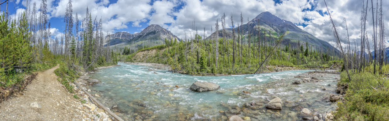
A pleasant panorama towards Stanley Peak (left) and Vermilion Peak (right) from the banks of the icy Vermilion River. Click to see larger.
.jpg)
.jpg)
LEFT: As we neared Marble Canyon, the highway came back into view and the riverbed began to take on a more canyon-like character.
RIGHT: Grandma keeps a tired Mera going by playing “wagon train” (whatever that is). By this point, Mera was closing in on 10-km of unassisted hiking which is an impressive feat for one with legs so little!
.jpg)
.jpg)
LEFT: Returning to Marble Canyon, we discovered that the first bridge was surprisingly devoid of people and made haste to cross it before the crowds returned! Beyond the bridge, a very short walk brought us to the parking lot and…
RIGHT: …TREATS! After a great day of hiking amidst fine Kootenay scenery, trailhead treats were deemed to be in order. As you can see, everyone chose something to their liking; Mera opted to drink a Bubly water like Gollum, Penny devoured a rainbow cookie and Brianne enjoyed a craft adult beverage!
Satisfied with a day full of Rocky Mountain scenery, we returned to the desolation of the Tunnel Mountain “campground” where the views were lacking but the company was good and the adult craft beverages were cold!
.jpg)
.jpg)
.jpg)