Elevation: 2442 m
Elevation Gain: 1100 m
Rogan Peak is the unofficial name of a highpoint located between Mounts Galwey and Dungarvan. Despite its unofficial status, Rogan is actually higher than officially-named Mount Galwey. Andrew Nugara originally called the peak “Dunwey” (since it lies between Mounts Dungarvan and Galwey). Following the birth of his nephew Rogan, however, Nugara opted to re-christen the peak in his honor.
My Ascents:
January 12 2019
Trailhead: Horseshoe Basin Trailhead GPS Track: Rogan (Dunwey) Peak
Many a husband has felt his heart sink upon hearing the following words from his wife’s mouth: “Honey, my mother is coming for a visit.” Houseguests cramp anyone’s style and the terrifying mother-in-law is the apex predator amongst these. As my “fight or flight” instincts kicked in, I opted for the latter (we all know that “Nannie” fights dirty). Under the cover of predawn darkness, Crux and I, therefore, packed our gear and escaped to the sanctuary offered by our beloved Canadian Rocky Mountains.
Weary of this year’s unstable snowpack, we drove mountain-wards hoping to find a lofty, but dry, front range peak whose towering summit would keep the marauding MIL at bay without the need to expose ourselves to potential avalanche hazard. As the sun rose to the south of Pincher Creek, our salvation appeared on the horizon. Rogan Peak’s ascent route was visible from the highway and it appeared to be remarkably snow-free! Having hoped to ascend Rogan for several years now, Crux and I, therefore, made haste. An escape from the houseguest to end all other houseguests atop a scenic summit? What a happy day, indeed!
Following Highway 6 south, we turned west onto the Bison Paddock road immediately north of Waterton. Continuing right at a fork, we followed a well-maintained dirt road along the paddock’s northern edge, reaching the gated (but unsigned) Horseshoe Basin trailhead a short time later.
Rogan Peak’s snowy east face appears beyond the gated trailhead with its foreboding appearance sure to dissuade any nearby mother in laws! Fortunately, the peak’s north-facing ascent ridge was much dryer for Crux and I. Unfortunately, it’s a 7 km hike from here to access that ascent ridge. The hike into Horseshoe Basin begins by following the northern edge of the Bison Paddock before ascending a 200 vertical meter rise and then dropping into the basin which lies between Rogan Peak (center) and Lakeview Ridge (right).
The hike into Horseshoe Basin was quite pleasant, however, it appears to have taken on a different character following the massive Kenow Wildfire in 2017. Previous trip reports showed this hike to be verdant and densely vegetated. Now, lush greenery has been replaced by wildfire-twisted remains. The combination of warm mid-winter lighting and charred vegetation made for a beautiful yet dreadful scene.
Not a speck of green left in this, once-lush, valley! From the top of the hike’s first rise, the route drops into the shaded basin ahead before curving north (right) up-valley between Rogan Peak (center) and Lakeview Ridge (right). Click to see larger.
Mount Galwey rears skyward from the fire-ravaged valley.
After crossing bone-dry Galwey Brook, the Horseshoe Basin trail veered north towards the head of this, now-dead valley, before switch-backing up steep slopes to the pass between Rogan Peak (out of sight to the left) and Lakeview Ridge.
While much of the area’s flora appear to have perished, the many, many prints that I saw suggest that its fauna had returned to graciously break trail for me! Much of the valley was bone dry, however, crusty snow drifts accumulated here and there causing some annoyance to Crux, myself and the local elk population.
A herd of elk (center right) take advantage of very gently-graded switchbacks to ascend the pass ahead. Despite their numbers and impressive size, they seemed genuinely concerned by the approach of a lone scrambler and his calm, on-leash dog. Imagine how scared they'd have been if a mother-in-law approached!
A closer look at the 8 elk who made impressive haste up the pass ahead of Crux and I.
Earlier on, I mentioned that the switchbacks up the pass are gently-graded. In fact, they’re too gently graded with their ascent angle bordering on flat! As a result, Crux and I opted to go straight up this once-forested slope to the pass. As we climbed, we were treated to improving views of Rogan Peak and its north ascent ridge. During summer months, the obvious snow-filled gully makes for a fine shortcut but, on this day, we opted to stay on dry ground given the considerable avalanche danger forecast.
Near the pass, we took a small break to refuel for the grind ahead. We’d already hiked 7 km and gained 500 meters but still faced the prospect of gaining an additional 700 m over the next 3 km. Complicating matters, we’d been hiking into a relentless 70 – 80 km/h headwind all morning and, now that we were finally set to turn south, the wind direction seemed to reverse as well. Nothing like hiking into the wind both ways!
After replenishing ourselves at the pass, I put on more wind gear to contend with the constant westerly barrage that, predictably, grew stronger on the ascent ridge. As we hiked along the ridge, I discovered that its many bumps and outcrops, which appeared small from below, were in fact quite large. Indeed, some looked downright menacing. Fortunately, all could be circumvented or overcome by non-technical means. These outcrops won’t deter a scrambler but hikers might feel a bit of angst here or there. I had expected that these bumps might provide the day’s crux but didn’t think that it would come in the form of an obstinate ram (center right) who seemed determined to prevent Crux and I from passing. After a couple games of “Baa Ram Ewe”, we ended up doing some, otherwise, unnecessary side-hilling to give him the wide berth he clearly felt entitled to!
Impressive views of Mount Dungarvan and a relentlessly fierce wind were our constant companions as we hiked ever upwards on Rogan’s ascent ridge.
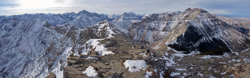
On and on we plodded into the stiff breeze yet Rogan’s summit never appeared to get closer! Indeed, it ended up taking us a full 2 hours to reach the peak (right) from the pass (far left). Fortunately, this trudge involved an ever-improving panorama of Waterton’s always stunning peaks and prairies. Click to see larger.
After a final slog up steepening scree slopes, we finally reached Rogan’s spectacular summit. Nary a mother in law to be found! Click to see larger.
My peak-bagging pup and I hunker down to avoid blowing off the mountain! Suffice to say, the vicious wind which buffeted us throughout our ascent did not abate on top. As I would proceed to take my myriad summit photos, I had to constantly brace myself to avoid being blown over. Perhaps I should have expected as much. This is, afterall, Waterton and there's obviously a reason this route was snow-free! Indeed, any snow which had previously fallen on this peak would surely have been blown clear through Saskatchewan in winds like this! Mercifully, the powerful chinook winds were, at least, warm!
“From the peaks to the prairies, wherever I roam…” Our fiery ascent route up Horseshoe Basin fills the foreground between Lakeview Ridge (left) and Bellevue Hill (center right). Beyond, vast prairies spread eastward in sharp contrast to the lofty Rockies both north and south of the 49th parallel. Click to see larger.
Lakeview Ridge and the great flat beyond to the east.
Montana’s Chief Mountain punctuates the horizon (center right) beyond fire-ravaged Bellevue Hill. Hopefully the Kenow fire counted some of the area’s many ticks amongst its victims…
Massive Mount Cleveland (center) highlights the view towards the “more impressive peaks” south of the border. On the Canadian side of things, Middle Waterton Lake separates Vimy Peak (left) from more proximate Mount Crandell (right).
Immediately to the south, Mount Galwey’s steep summit block gives it a reputation as a formidable scramble. The dramatically pointed mountain in the distance to the left is the Stoney Indian Peaks. To its right, Cathedral Peak, Heaven’s Peak, Mount Vaught, Mount Richards, Kootenai Peak and Bertha Peak can also be seen.
Looking south, the winter sun sits low in the sky casting a golden glow over the sea of peaks beyond the long, airy ridge connecting Rogan Peak to Mount Galwey (left).
To the west, Mount Blakiston towers above Rogan Peak’s precipitous southeast face.
Mounts Blakiston (left) and Dungarvan (right) bookend the many peaks of the Red Rock Parkway. Click to see larger.
Despite its fearsome appearance, Anderson Peak (center) is an easy scramble and remains high on my to-do list; that is, if the access to it reopens. Kenow Mountain is visible in the distance immediately to the left of Anderson and was the epicenter of the Kenow Wildfire which so dramatically altered this landscape. Two years ago, this photo would have been filled with forests. Today, all that remains are charred remnants.
Nearby Mount Dungarvan is rumored to be one of the finest scrambles in the area though its usual access is now closed as the result of the wildfire.
Looking north beyond Mount Dungarvan and Spread Eagle Mountain towards the more distant Livingstone and High Rock Ranges.
A classic chinook arch takes shape directly overhead. The area to the north of Rogan Peak is known as “Oil Basin.” Not surprisingly, Shell’s Waterton Gas Plant is located in this area some 18 km from the summit. Click to see larger.
A two-handed summit selfie. With the wind still pummelling me, I didn’t trust my camera in only one hand and a self timer shot was absolutely out of the question!
Just how windy was it? Why not ask Crux? Suffice to say, despite the phenomenal views, we did not linger atop Rogan Peak. Once photos had been taken in every direction, we beat a hasty retreat!
That’s better! After descending a good way, we were finally able to find a lee area suitable for a break. Having been on the go without eating or drinking for some time, I enjoyed the most spectacular cup of tea and apple ever. I had, briefly, attempted to drink some tea on the summit but it literally blew out of my cup within instants of being poured!
Mangled, low-lying vegetation attests to the area’s common windiness. Apart from their interesting appearance, these shrubs were noteworthy in that they were the first living vegetation I’d seen all day.
Long shadows spill over the pass into Oil Basin in the same manner that the Kenow Wildfire did 2 summers earlier. Click to see larger.
Looking down Horseshoe Basin (and our upcoming 7 km deproach) from the pass. Although the hike out is trivial, I wasn’t sure that we’d make it back to the car before dark. At the very least, the wind had finally abated so our long walk out would be peaceful.
The moon rises over Bellevue Hill’s burnt matchstick forest.
Sunset lighting bathed the intersection of peaks and prairies as we descended the day’s final rise.
Apparently this massive herd of elk can’t read signs. This is supposed to be the bison paddock!
In a display of remarkable timing, the sun set behind Rogan Peak just as we arrived back at the trailhead parking area. Rogan Peak is an outstanding scramble, complete with an interesting approach through fire-ravaged valleys and a summit panorama that rivals that of many larger peaks. At > 20 km round trip and 1,360 cumulative vertical meters, it is, however, a significant undertaking on a short winter day!
The sun sets and the moon rises after another spectacular (mother-in-law-less) day in Waterton National Park. You’d think that a long, windy day like this would be draining but I found it to be quite the opposite. As I embarked on the 3 hour drive home to Calgary, I felt rejuvenated and ready to face the rest of our visit with my mother-in-law.
(With sincere apologies to my mother-in-law "Nannie" who I actually like very much and who helped my wife watch our girls allowing Crux and I to enjoy a beautiful day to ourselves in the mountains. Lucky for me, she's got a good sense of humor!)
.jpg)
.jpg)
.jpg)
.jpg)
.jpg)
.jpg)
.jpg)
.jpg)
.jpg)
.jpg)
.jpg)
.jpg)
.jpg)
.jpg)
.jpg)
.jpg)
.jpg)
.jpg)
.jpg)
.jpg)
.jpg)
.jpg)
.jpg)
.jpg)
.jpg)
.jpg)
.jpg)
.jpg)
.jpg)
.jpg)
.jpg)
.jpg)
.jpg)
.jpg)
.jpg)
.jpg)
.jpg)