Picacho Peak is a classic Arizona scramble which features wire cables to assist hikers across YDS Class 2, 3 and 4 terrain. As such, it’s one of the few via ferratas in the United States. These cables allow thousands to reach the summit each year so don’t come to Picacho Peak seeking solitude! Crowds aside, Brianne remembered having a blast on Picacho Peak when she climbed it with her dad and sister in 2011. Apart from fun, cables and dropping a water bottle on a poor hiker below her, however, Brianne remembered very little about Picacho Peak. When it came time to pick our annual escape-from-the-kids Arizona scramble, she was therefore keen to repeat it (and I was certainly not opposed to checking it out for myself).
After depositing our “little monkeys” with her parents in Apache Junction, we made a speedy getaway south towards Picacho Peak State Park (likely escaping before the grandparents realized what had occurred!). Following a thoroughly unnecessary side trip to Casa Grande for gas, we continued down the I-10 south, admiring Picacho Peak’s shapely silhouette as it grew closer and larger. Following obvious signs, we easily found the state park and paid our $7 fee to enter.
.jpg)
From the “Hunter” trailhead, Picacho Peak certainly looks formidable! It also looked very green after a week of heavy rains (and snow elsewhere in the state). The “Hunter” trail is the shortest and most popular way up Picacho Peak. After starting innocently enough, the trail quickly steepens before switch-backing through a prominent break in the peak’s cliffs and reaching a saddle (mouse over to see the general route).
.jpg)
Picacho Peak is famous for its proliferation of golden Mexican Poppies which, thanks to the recent precipitation, were blooming all over its lower slopes.
.jpg)
Brianne makes her way up the steepening lower mountain’s Class 2 terrain with relative ease – “Look Ma! No hands!”
.jpg)
Route finding on Picacho Peak borders on idiot-proof thanks to the “Hunter” trail’s popularity, many signs and cables. There’s really no need to download a GPS track before heading up this peak.
.jpg)
Uncharacteristically green hillside, a massive magmatic rock and an eye-catching outlier highlight the view as we continue up Picacho’s lower slopes.
.jpg)
The “Hunter” trail ascends Picacho’s northern aspect so the peak’s vertical summit block soon obscured the sun, providing welcome shade for much of our hike up to the saddle.
.jpg)
Brianne poses after reaching the base of a massive cliff face. From here, the route continues along a broad ramp which follows the base of the cliffs to the west (climber’s right).
.jpg)
You never know what kind of terrifying things you’ll see if you peer into the small caves which adorn the cliff’s base…
.jpg)
After enjoying a shady hike up along the broad and prominent ramp which bisects 2 significant rock bands, we reached the saddle and were treated to our first southward views. From here, the trail crosses over to Picacho’s south aspect, descending about 75 m (250 feet) before turning east and starting upwards once more. From the saddle, signs and cables (bottom right of this photo) make this descent stupid-obvious but that still didn’t stop another couple from asking us for directions.
.jpg)
Brianne dons stylish gloves and starts down from the saddle on a steep section of somewhat exposed, down-sloping, worn rock. Without cables, this stretch would certainly be daunting but, with them, it felt secure and straightforward.
.jpg)
Looking back up as another hiker descends from the saddle.
.jpg)
Once the trail bottoms out, it cuts back to the east along another prominent ramp before zig-zagging up ledges to surmount a large rock band (a scrambler is visible ascending the rock band in this photo just above the sky-silhouetted cactus on the center-right). Mouse over to see the approximate route.
.jpg)
My lovely hiking model pauses to admire the view near a conspicuous cactus. Sadly, this cactus appears to have been prodded and poked by many passers-by. I can only hope that it poked a few of these boors right back!
.jpg)
Having reached the end of the rock ramp, Brianne fearlessly powers up the large rock band. The wires continue up and out of sight around the corner above her. The out-of-sight section just above her also featured significant exposure (class 4 IMO). Fortunately, the wires helped to alleviate the uneasiness that might result from similarly “airy” but unprotected perches.
.jpg)
Above the “airy” corner, the angle subsided and the trail continued east through a large hanging bowl (the edge of which is just visible to the left of this photo). This hanging bowl provided beautiful desert outlooks and was quite mellow…until it ended in a near-vertical 4 – 5 m (20 – 25 foot) wall! Mouse over to see approximate route.
.jpg)
Using wires to pull myself up a steep crack in the near-vertical wall. Most of the crack felt like class 3 scrambling but the last meter or so was steepest and, without wires, might be up to class 4.
.jpg)
Looking back as Brianne tops out on the near-vertical wall with the trail through the hanging bowl obvious a good distance below her.
.jpg)
Wires continue to mitigate the sense of exposure as Brianne makes her way up the mellower class 3 terrain above the wired wall.
.jpg)
A panoramic view of the hanging bowl and desert floor below a scenic sub-summit. One aspect of this scramble that really impressed me was the different microclimates on Picacho’s sunny but very arid south side (shown here) and its much greener, shaded north aspect. It was remarkable to see completely different sets of flora meters from one another depending on what side of the peak you were on. Click to see larger.
.jpg)
Brianne uses an unexpectedly loud (!) catwalk to overcome a final igneous obstacle before topping out on Picacho Peak’s broad summit ridge.
.jpg)
Once on the summit ridge, a final stretch of easy class 2 terrain leads up to Picacho’s pyramidal summit (the easternmost peak on the summit plateau).
.jpg)
Brianne is all-smiles on the summit (just like the last time that she was up here 8 years ago). Her memory may have failed her with regard to the scramble’s details but she was sure right about Picacho Peak being fun (and better still, she didn’t drop heavy objects on anyone else this time)!
.jpg)
Scenic summit flora.
.jpg)
Native desert grasses contrast the greener fields being cultivated to the southwest.
.jpg)
A telephoto towards the out-of-place looking, lush, green, irrigated fields nearby. The prominent mountain in the distance is likely Gu Achi Peak.
.jpg)
The I-10 continues southeast over unimaginably flat desert towards Tuscon, which is bracketed by the Santa Catalina Mountains (left) and the Tuscon Mountains (center).
.jpg)
Waason Peak (center) rises up over Tuscon 47 km to the southeast. Impressively, Mount Wrightson (center right) is even visible in the background some 116 km away!
.jpg)
Brianne enjoys a view of the I-10 and the Santa Catalina Mountains with her lunch.
.jpg)
The highest of the Santa Catalina Mountains: snowy Mount Lemmon.
.jpg)
Snowier peaks on the distant northern horizon (right) provide a stark contrast to arid Newman Peak across the I-10 corridor. Unfortunately, Newman Peak completely obscures the view towards the Phoenix area and the scenic Superstition Mountains.
.jpg)
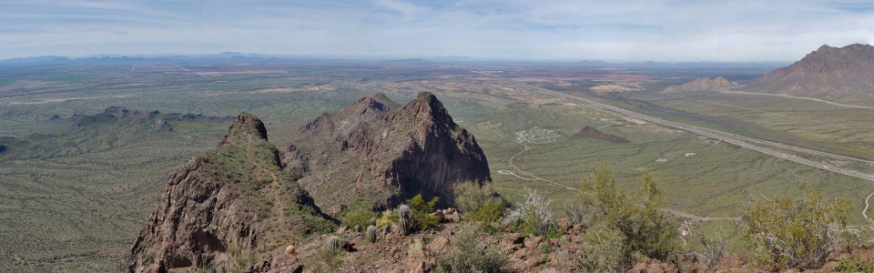
Picacho’s own sub-peaks are probably the most scenic part of the summit panorama. Click to see larger.
.jpg)
A closer look at Picacho’s scenic sub-peaks which stretch out to the northwest from its main summit. On our way down, we followed the obvious well-beaten path to Picacho’s second highest peak (center left) to check out the view from there as well.
.jpg)
A summit shot with my Love marks the (literal) high point of our afternoon away from the kids! Once lunch was consumed and summit photos aplenty had been taken, we started to miss our “little monkeys”, however, and, so, started down shortly thereafter.
.jpg)
Enjoying the sun on our skin and fine desert views as we hike northwest along Picacho’s broad summit ridge to its second highest peak.
.jpg)
Yours truly on Picacho’s scenic secondary summit. A special thanks to Brianne for not taking a photo with my feet cut off (for once)!
.jpg)
The hike back from the false summit provided some excellent views of the 4 – 5 m crux wall that we’d soon have to descend. Normally, I’d be apprehensive about descending this kind of terrain but, with wires, I was confident that our descent would go smoothly. Mouse over for approximate route line.
.jpg)
Our descent begins as Brianne retraces her steps over the small catwalk (this time taking care not to stomp it with undue force).
.jpg)
Looking down the 4 – 5 m crux wall. What goes up…
.jpg)
After navigating Picacho’s technical cruxes (the 4 – 5 m wall and the airy corner) with relative ease, we reached the true crux of the day: climbing 75 m back up to the saddle! Ugh!
.jpg)
Taking in Picacho’s impressive saguaro-dotted cliffs as we go.
.jpg)
At the saddle, the landscape instantly grew greener as passed under Picacho’s impressive summit (visible in the sun above Brianne) and made our way back down the prominent rock ramp towards the welcome shade below. Click to see the saddle’s lovely view in a larger format.
.jpg)
After a speedy descent from the saddle, we soon reached the trailhead and its proliferation of poppies. Pichacho Peak provided some wonderful scrambling and some much-needed fun away from the kids for Brianne and I (thanks again to “Nannie” and “Papa” for watching our monkeys!). Eager to see how the kiddos were doing, we made a quick pit stop to refill water bottles at the nearby visitor center and then started our hour and half drive back towards Apache Junction.
.jpg)
Oops! Looks like we must have taken a “wrong turn” somewhere on that drive home to the kids…oh well! While our drive to Picacho Peak featured an all-together unnecessary diversion through Casa Grande, our drive home involved a much-needed side-trip to the Desert Eagle Brewing Company! What can I say, we worked up a thirst on Picacho that just couldn’t be satisfied with water from the State Park Visitor Center! Mouse over to see who LOVES good craft beer after bagging a peak!
.jpg)
.jpg)
.jpg)