On June 25, I ironed my pants and donned a nice shirt and tie (a rare occurrence, indeed). Of the work meetings that brought me to Denver, this morning's was, no doubt, the most important. As the central air whirred to life in a basement ballroom at the Sheraton, I delivered my presentation and defended my position on all variety of intriguing issues ranging from turbine oil acid limits to the persistence of emulsions. Exciting stuff to be sure. Following the most important meeting of the trip, I enjoyed the satisfaction of knowing that the agenda which I'd come to propose now appeared to be in motion. I attended subsequent meetings but was pleased to make less of a show of myself there. In this windowless business world, a ticking clock provided the only evidence for the passage of time. Like all good things (and many otherwise), the day's meetings would eventually come to an end and, when they did, I decided to make up for lost time. The better part of the day had passed but the days in June are long and the mountains were calling!
.jpg)
After trading my dossier, shirt and tie for boots, poles and an ax, my metamorphosis from professional to peak-bagger was complete and my rental car and I made haste for Loveland Pass's alpine environs. The Pass is located only an hour west of Denver and is reached via the highest year-round road in North America. This short drive and high elevation trailhead made it a perfect place for an after-work hike on the most meeting-filled day of my trip. There was no sense spending what was left of the day hiking below tree line when I could drive to an elevation 110 m higher than the summit of Mount Temple back home!
.jpg)
As I geared up at the trailhead, I noticed 2 things:
1) Holy $hit - the air was thin!
2) This sign suggesting that I'd best be back to the car by 7pm. Still, the sign doesn't actually forbid parking after 7 pm...
.jpg)
Within seconds of leaving the tourist-filled parking lot, my objective for the evening (Mount Sniktau) came into view on the left. With only 550 vertical meters and 3 km separating me from its summit, I figured that I could easily summit my first Colorado 13er and be down before the 7pm parking restriction. During my pre-trip research, I'd also noted that a high traverse between Sniktau (left), "Cupid" (center left) and Grizzly Peak D (center) was possible though it seemed unlikely that I'd have time to complete it on this day. Click to see larger.
.jpg)
A well-established trail provides evidence of Mount Sniktau's popularity. Following it upwards, I felt low on power and, aware that I'd not been this high in years, set a very conservative pace. With such a short objective in mind, there really was no need to rush anyways so I enjoyed the crisp, cool (and thin) air, stopping frequently to photograph the beautiful alpine meadows all around.
.jpg)
Views south towards the (still-operating!) Arapaho Basin ski area. A late-June after-work ski was also tempting but hiking Mount Sniktau had the advantage of not requiring a lift ticket purchase is US dollars!
.jpg)
Enjoying the view west towards the still-very-snowy Continental Divide.
.jpg)
Evidence of a spectacular cornice failure under the summer sun. More impressive still, a lot of cornice was left to fail!
.jpg)
Two paths diverge. After ascending rolling alpine meadows, the trail eventually split and I kept left to continue up Mount Sniktau. To the right, an equally established trail led towards "Cupid" and Grizzly Peak D. Click to see larger.
.jpg)
After a series of false peaks, red rocks and a cornice highlighted the final stretch of ridge below Sniktau's shapely summit.
.jpg)
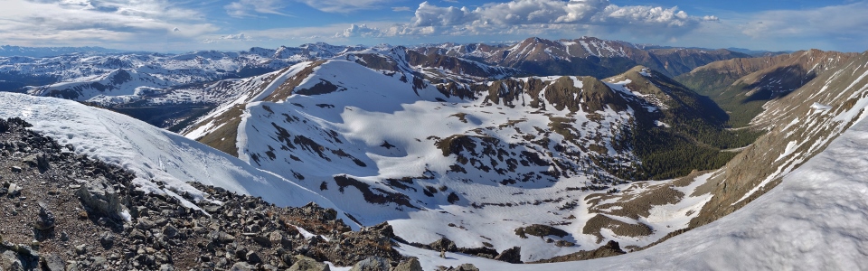
Despite cyclone summit winds, I felt completely at peace as I stepped onto Sniktau's 13,240-foot-high summit. Perhaps it was the satisfaction of knowing that my work meeting had gone very well. Perhaps it was the meadows all about (which were tranquil apart from the constant westerly blasts). Perhaps it was my altitude-inspired lackadaisical pace. Regardless, this felt like a place to relax and reflect on all that is good in life. Click to see the southern section of the summit panorama which so soothed my soul in more detail.
.jpg)
14er Mount Evans (center right) sneaks into view beyond Kelso Mountain (center) to the east.
.jpg)
Mount Edwards (left) and a couple of 14ers (Torreys Peak and Grays Peak - right) to the southeast. For ambitious parties, a 5 peak traverse from Sniktau to distant Grays Peak is possible.
.jpg)
Grizzly Peak D (left) and "Cupid" (center) are the 2 peaks you'd need to hike up and over to complete the grander 5 peak traverse to Torreys and Grays.
.jpg)
Looking southwest towards Mount Guyot and Bald Mountain on the left while 14ers Mount Bross, Mount Lincoln, Mount Democrat and Quandary Peak rise up in the center.
.jpg)
To the west, the I-70 snakes its way beneath the Continental Divide thanks to the Eisenhower-Edwin Johnson Memorial tunnels. Click to see larger.
.jpg)
The second-highest peak in the Rockies (obviously a 14er), Mount Massive was also visible some 76 km away (center right). In the foreground, a host of closed ski hills provide the only evidence for this photo have been taken in summer.
.jpg)
14er Mount of the Holy Cross to the west (center). Surprisingly, the characteristic snow cross for which this peak is named is obvious enough to be apparent from 60 km distant! Mouse over if you don't see it.
.jpg)
Life is good!
.jpg)
Red Peak (left) and Mount Valhalla (right) rise up beyond, yet another, ski hill.
.jpg)
The sun catches the peaks of the Gore Range to the north of Vail.
.jpg)
Filled with snow, reddish rock and alpine meadows, the panorama to the north reminds me of Parker Ridge in the Canadian Rockies (except that the American panorama features an Interstate in the valley instead of an icefield!). Click to see larger.
.jpg)
What? What? What mountain boy? Why, Hagar Mountain, the Citadel and Pettingell Peak to the northwest (of course).
.jpg)
Despite Mount Sniktau's popularity, I enjoyed an hour on its summit with only this pika (foreground center) for company.
.jpg)
To the east, the I-70 winds its way down-valley towards Denver. Click to see larger.
.jpg)
Active afternoon weather beyond Mount Vasquez (foreground right). Fortunately, the storm systems appeared to be limited to the east side of the Divide away from my Sniktau sanctuary.
.jpg)
Woods Mountain (left), Mount Parnasus (center) and Bard Peak (center right).
.jpg)
Like I said, life is good! With no sense of urgency to move on, I decided to craft a stony seat from flat rocks near the summit's snow-filled windbreak. From my high-altitude armchair, I even put my camera down for a few minutes to be present in the moment rather than thinking of the trip report that I'm now writing.
.jpg)
After getting more Zen than I usually do on mountains, I remembered that part of my ascent had taken place while still, technically, on the clock so I answered a few work emails to cover my a$$.
.jpg)
Having completed my summit photography, summit meditation and summit email correspondence, I figured that the time had come to start back down. Noting that "Cupid" (center left) looked to be practically on the way down, I figured I might also pop over to it so that I could claim another multi-peak day. Of course, this "Ah - what's 1 more peak?" attitude can be dangerous with people like me...
.jpg)
In love with "Cupid's" gentle ascent slopes. What a chill way to round out my evening! 😘
.jpg)
Meandering meadows give way to the 14ers of the more-distant Mosquito Range.
.jpg)
At the risk of sounding Canadian, "F*ckin' eh!" The sun finally came out as I reached the summit of "Cupid" granting spectacular views that more-than justified a extra ups and downs on the way from Mount Sniktau (center right). Just when I thought my evening couldn’t get any better! Click to see larger.
.jpg)
The trio of Hagar Mountain, the Citadel and Pettingell Peak looks even better without overcast skies!
.jpg)
Spectacular evening lighting on the Continental Divide. Click to see larger.
.jpg)
The grand traverse continues over Grizzly Peak (center) towards Torreys Peak and Grays Peak (left). Click to see larger.
.jpg)
A smile that can only mean one thing: plotting another summit! As I came to the realization that it only took me 45 minutes to traverse from Sniktau to "Cupid", I began to wonder if I could tackle the more-difficult-looking traverse to Grizzly Peak D in a similar timeframe. I also began to wonder how strict that 7am to 7pm parking rule was... 🤔
.jpg)
As my three-year-old would say: ARE DOING IT! With Grizzly Peak so close-by and the evening lighting so lovely, it would almost be stupid not to climb it…
.jpg)
With oxygen at a premium and energy levels low, I'd hiked up Mount Sniktau at a very relaxed pace. After all, I was in no rush. As I continued my day up "Cupid", I hiked with a bit more haste knowing that the hour was drawing late. As I decided to truly push my luck by continuing on to Grizzly Peak D, my pace quickened to "All Guns Blazing." Thin air or not, this peak was going to happen and it had to happen FAST!
.jpg)
Looking back towards “Cupid” and the day’s crux: a spine of large, loose boulders. Though completely non-technical, this ankle-twisting labyrinth was a little annoying given that I was, suddenly, in quite a hurry. From here, most of the boulders can obviously be bypassed on steep snow but, from above, it was impossible to tell if this snow was part of an ill-advised cornice bypass.
.jpg)
A good reason to be cautious on the snow here! This cornice certainly looked ready to plummet at any moment.
.jpg)
From the second saddle separating “Cupid” and Grizzly Peak D, the final 215 vertical meter slog is all that’s left. Now to see how quickly I can bomb up this rubble slope with 40% less oxygen than would be available at sea level...
.jpg)
Although the slope appears somewhat intimidating from afar, it’s just a steep, rocky hike once you’re on it. While this type of terrain is generally tedious, I felt challenged by the late hour and pushed myself hard. I breathed deeply while my heart raced to circulate precious oxygen. Sweat poured from my brow. Earlier, I’d casually hiked at a relaxed pace. Now I was racing and I felt alive!
.jpg)
A goat print suggests that others had recently enjoyed this fabulous scree slope as well.
.jpg)
The reward for my rapid ascent of Grizzly Peak D: a spectacular summit atop which I could finally catch my breath. Click to see larger.
.jpg)
US Highway 6 weaves its way up to the trailhead at Loveland Pass. From Grizzly Peak D, the pass parking lot looked quite distant and I wondered what sort of Herculean pace I’d need to maintain to get back there in 45 minutes. Perhaps if I’d brought skis like someone else clearly did (note the tracks in the immediate foreground), I’d have a hope in hell of making it.
.jpg)
Looking north along the undulating ridge that separates Grizzly Peak D from “Cupid” (center left) and Mount Sniktau (center right). Note that the traverse features 2 unnamed bumps that are nearly as high as either “Cupid” or Sniktau. Thanks to these many ups and downs (on the way in and out), my cumulative elevation gain for the day would end up being a very respectable 1260 m (4134 feet)! Not bad for an after-work “quickie!”
.jpg)
Mount Parnassus (center left), Bard Peak (center) and lowly Baker Mountain (middle-ground right) rise up above Grizzly Gulch to the northeast.
.jpg)
14ers Torreys Peak (left) and Grays Peak (right) look tantalizingly close…it would be a shame not to climb them on an evening this nice, right? Lol…jk. 😂
.jpg)
The southern panorama featured Chihuahua Lake, still entombed in ice and snow, at the base of impressive east-facing cliffs. Click to see larger.
.jpg)
Santa Fe Peak (center left) rises up at the far end of Chihuahua Gulch.
.jpg)
The Arapaho Basin ski area still looks to be in fine form beyond the jagged ridge which connects Grizzly Peak D to Lenawee Mountain.
.jpg)
Looking southwest towards Dillon and its reservoir.
.jpg)
Work hard and play harder! Loving my third after-work summit of the day!
.jpg)
With the sun sinking beyond the Continental Divide to the west, I reluctantly decided that it was time to end my summit sejour with 45 minutes to make it back to the Loveland Pass parking lot some 4.5 km away and 600 m below. Sounds doable, right?
.jpg)
A sad find as I retraced my steps between Grizzly Peak and (back up – ugh) “Cupid.” It seems that the goat who left prints high on Grizzly Peak may not have fared well. Poor goat. Despite the alleged absence of grizzlies in Colorado, this relatively recent kill had me on high alert (and had me wondering how I walked by it on the way up without noticing!). I had a hard time imagining what else could have done this once-beautiful animal in…Yo Bear!
.jpg)
Spectacular evening views as I make my way back up (and over – ugh) “Cupid,” imagining a hungry grizzly bear around each outcrop.
.jpg)
Descending “Cupid’s” mellow slopes. As the day’s final uphill came into view (right), I decided to go off-piste and side-hill back towards Loveland Pass (center left) using the obvious snow slopes and grass ramp. Enough of this up and down and up and down and up and down non-sense!
.jpg)
Mercifully, the snow slopes that I opted to shortcut across proved supportive! Going off-piste to avoid a final 60 m elevation gain might have proven really stupid (even by my standards) if I’d ended up post-holing all the way back to the trailhead. In addition to being supportive, these snow slopes provided one final breathtaking view (click to see larger) as I boot-skied down them in the hopes that my car was not locked in the parking lot overnight…it was now 7:30pm – whoops! 🤷
.jpg)
As I returned to the parking lot, I was pleased to see that I wouldn’t be spending the night at Loveland Pass (it seemed unlikely that my rental Hyundai’s backseat would have been as comfortable as my room at the Sheraton). There was no locked gate and cars were still pulling in. In fact, as near as I could tell, no one paid any attention whatsoever to the parking hours posted (not that I did either, mind you)! Tired from the torrid pace I’d set on the latter half of the evening’s adventure, I keeled over on the hood of my car and snapped a selfie to capture the essence of the moment.
.jpg)
With the sun setting and my stomach rumbling, I found a remarkable brewery/restaurant to sate my thirst and hunger about halfway back to Denver. Highly recommended for any craft beer (or mac and cheese) lovers passing by Idaho Springs, CO!
.jpg)
A satisfying end to an overwhelmingly satisfying day. 🍻 Now to get back to my room in time to iron my shirt and pants for tomorrow’s meetings…
.jpg)
.jpg)
.jpg)
.jpg)
.jpg)
.jpg)
.jpg)
.jpg)
.jpg)
.jpg)
.jpg)
.jpg)