Mount Evans
Elevation: 4350 m (14271 feet)
Elevation Gain: 40 m (131 feet)
Originally named Mount Rosa, Mount Evans is a prominent Front Range 14er which dominates the Denver area skyline. It is likely that Mount Evans was first ascended by Albert Bierstadt in 1863. Bierstadt christened the peak Mount Rosa after the wife of another man (who Bierstadt would later marry). In 1895, the peak was officially renamed Mount Evans to honor Colorado’s second Governor John Evans. Prior to his career as a politician, Evans was a physician who founded numerous hospitals and medical associations in addition to playing a role in the founding of Northwestern University and the University of Denver. Evans was a personal friend of Abraham Lincoln, who appointed him Governor of Colorado. Evans’ time as Governor was marred by his role in the Sand Creek Massacre. Fearful that Denver could be overrun by nearby tribes while most men of fighting age were involved in the American Civil War, Evans ordered “friendly Indians” to present themselves to various forts for their own “safety and protection.” Those who did not comply were deemed “hostile” and Evans authorized citizens to pursue, “kill and destroy” them. On November 29, 1864 Colonel John Chivington followed these loathsome orders and killed 163 unarmed men, women and children belonging to the Cheyenne and Arapaho tribes at Sand Creek. As of 2019, the US Geographic Board is considering alternate names for Mount Evans. The name Mount Cheyenne-Arapaho has been proposed to honor the massacre’s victims. Despite the sins of its namesake, Mount Evans is a beautiful peak which formed following a magma intrusion 1.4 billion years ago. The surrounding sedimentary layers of rock wore away long ago leaving a batholitic granodiorite core which was later carved by glaciers. Indeed, Mount Evans sports the deepest cirques in the Colorado Rockies, many of which are now home to lovely lakes/tarns. In 1930, the Mount Evans Scenic Byway was completed 15 years after roadwork began. The Scenic Byway rises 2100 m over 45 km and culminates a mere 40 m below the summit of Mount Evans making it the highest paved road in North America. Thanks to ease of access, Mount Evans is a hotspot for tourism and scientific research ranging from the impacts of altitude to particle physics. Mount Evans is also home to the world’s third-highest observatory.
My Ascents:
June 27 2019
Trailhead: Mount Evans Scenic Byway Summit Parking
After hiking to the top of the highest peak in the Rockies earlier in the day (and tagging 8 other summits over the course of the previous few evenings), my 4-day Colorado adventure was drawing to a close. Having managed to balance 9 new peaks with work commitments, the trip had proven more productive than I ever imagined it might. Still, 9 summits is a bit of an awkward number and an even 10 sounded much better to me…
Luckily, I had the perfect peak in mind for my tenth and final Colorado summit. Mount Evans is a spectacular 14er which I’d already seen during many of my earlier ascents. It also happens to have a paved road that stops only 40 m (130 feet) below its summit and was “only” 90 km out of my way as I drove back to Denver. Indeed, with blisters on my feet and a combined 4665 m (15305 feet) elevation gain over the past few days, a drive-up peak sounded like a pretty brilliant idea at this point!
.jpg)
Work smarter not harder! After a busy few days, I was quite content to let my little rental Hyundai do the heavy lifting during my ascent of Mount Evans.
.jpg)
After ascending an exciting 1500 m or so on a twisty, turny mountain road, I decided to stretch my legs at, still-frozen, Summit Lake. Beyond the icy tarn, Mount Evans’ summit is visible atop a steep, scenic cirque. Yep – that’s right. I’m about to drive up there! 😁 Click to see larger.
.jpg)
As I stepped out of my car, I noticed that I wasn’t the only one enjoying the views of Summit Lake!
.jpg)
The most majestic, spectacular, amazing animal on the face of the planet: the graceful mountain goat.
.jpg)
Even majestic and graceful creatures post-hole apparently!
.jpg)
On the road again (literally). After gawking at goats, I eventually pulled myself away so that I could resume my automobile-assisted ascent.
.jpg)
Rock Star parking at 4310 m elevation!
.jpg)
From the parking lot, the remainder of the climb to Evans’ summit looked manageable… 😉
.jpg)
Ugh – you mean I can’t drive to the summit?!
.jpg)
Lovely views from the well-trodden tourist path that switchbacks its way up the final few meters from the summit parking lot to the summit proper.
.jpg)
A colorful tourist takes in the spectacular view from Mount Evans’ boulder-strewn summit. Despite the summit’s ease of access, most people seemed content to enjoy the views from the parking lot just below. Surprisingly, I’d shared the summit of Mount Elbert with more people earlier in the day than were on Mount Evans!
.jpg)
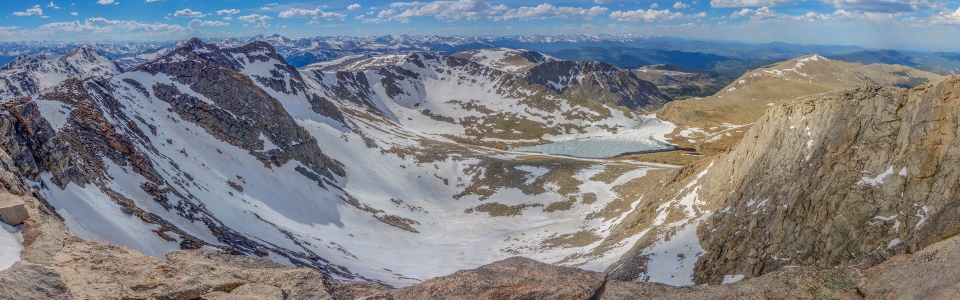
Scenic Summit Lake occupies the base of a spectacularly snowy cirque which falls dramatically away from Mount Evans’ summit. You don't get to see this view from the parking lot so I'd highly recommend "hiking" the extra 5 minutes to witness it for yourself! Click to see larger.
.jpg)
Nearby Mount Bierstadt (named for the man who, likely, first ascended Mount Evans).
.jpg)
Looking west beyond Bierstadt towards 14er Quandary Peak (center left) and the Mosquito Range.
.jpg)
Further west, the giants of the Sawatch Range are also visible including 14er Mount of the Holy Cross (center).
.jpg)
Mount Evans’ nearby west peak looks to be of similar height. I’d have been curious to wander over with a GPS to check its relative elevation but I left my handheld unit in the car and lord knows I wasn’t going down 40 m and then coming right back up! What do I look like? A mountain climber? 😜
.jpg)
A lone figure stands atop Evans’ west peak, providing an impressive sense of scale.
.jpg)
Looking northwest towards 14ers Grays Peak and Torreys Peak. Less-impressive Mount Sniktau (site of my first Colorado 13er two evenings prior) is also visible (third bump from the right of the photo).
.jpg)
A host of nearby Front Range peaks including (from left to right): Mount Sniktau, Hagar Mountain, the Citadel, Pettingell Peak, Mount Parnassus, Bard Peak, Byers Peak and Mount Spalding (immediate foreground).
.jpg)
Distant 14er Longs Peak is faintly visible on the very front edge of the mountains over 70 km beyond Summit Lake.
.jpg)
The rest of the summit crowd (including someone hell-bent on re-enacting a Juicy Fruit commercial).
.jpg)
A panorama filled with tourists coming and going to the southeast. Click to see larger.
.jpg)
Interesting lighting and active weather to the east towards Denver.
.jpg)
The Meyer-Womble Observatory and nearby Rosalie Peak. In the distance, 14er Pikes Peak is also visible on the right-hand horizon some 100 km away.
.jpg)
Round-topped Mount Logan (left), Mount Blaine (center) and Kataka Mountain (right) to the south.
.jpg)
A happy Matt atop his 10th new summit of the trip. With three 13ers and five 14ers under my belt, I decided that it was time to head down for an overdue call home and a well-deserved ale (or two…)!
.jpg)
Even when the hike is only 40 vertical meters, people (somehow) still managed to get off-route on Evans!
.jpg)
After enjoying a spectacular half hour soaking in the summit views, I enjoyed the equally entertaining drive back down the Mount Evans Scenic Byway to Idaho Springs.
.jpg)
And once back in Idaho Springs, I enjoyed an overdue video chat with my girls back home followed by another amazing round of beers at the Tommyknocker Brewery. Satisfied with the ales, the ridiculously good mac & cheese and the 10 new summits I’d visited, it was time to head back north to my end of the Rockies (and more importantly to my beautiful girls).
So long Colorado! I get the strangest feeling that I’ll be back someday… After all, 10 Colorado summits is kind of an awkward number. A cool dozen might be the way to go…
.jpg)
.jpg)
.jpg)