June 26 dawned much as the previous day had. I woke to the early morning light and views of crack-heads out the window of my hotel room (pro tip: insist on a room on a higher floor at the Denver Sheraton). As I readied myself for the morning's work meetings, I checked the weather and noted that it was, once again, supposed to be spectacular out. When my boss told me to go to Denver months earlier, I'd hoped to have at least 1 day of clear weather for an after-work hike. Today looked like it would be my third straight day of clear, sunny skies! Excited (for the sunny skies or the meetings?), I grabbed my morning tea and located the correct meeting room amidst the labyrinth that was the Sheraton's basement (several route finding failures occurred but I eventually found the right room).
As I dutifully took notes throughout the meeting, my mind occasionally drifted to the snow-capped Rocky Mountains immediately to the west. With meetings scheduled until almost lunch time, I hoped to be able to enjoy another evening summit today. Suddenly, the sight of business folk packing up their briefcases roused me from my daydream. What was going on? As I reengaged with the present, I discovered, to my great surprise, that the meeting had ended nearly an hour and a half early! Knowing that I still had work to do, I packed my things up and schmoozed for the appropriate amount of time outside the meeting room with the right people. As my boss would say, "gotta play the game." Once the "game" was over, however, I found myself without immediate commitment and on the doorstep of Colorado's spectacular Rockies. Let's be honest. We all knew how this was going to turn out all along!
Having anticipated being in meetings all morning, I'd short-listed a couple of suitably short peaks that would make for good after-work targets (just like yesterday...). With my day over earlier than anticipated, however, my plans got thrown for a loop. Luckily, a peak-bagger is always prepared! During my pre-trip research, I'd identified a potential four'fer of 14ers ("Decalibron") that I could climb. While the possibility of seriously padding my summit stats initially excited me, I ultimately wrote these peaks off. Four 14ers represent a significant undertaking (especially during a late summer and record snow year) and I knew that I wouldn't be able to squeeze them in while fulfilling my work obligations. When those work commitments eased, however, things changed. As quick as you can say "Seriously, Matt?", I had lost my business-casual attire and was setting a good pace through the Sheraton lobby with snowshoes and an ice axe strapped to my pack (there were some stares given that it was 34 C outside).
.jpg)
After a 2 hour drive that included a painfully full bladder and a very long alternating one-way traffic zone on the highway, I reached the Kite Lake trailhead with my trusty "compact SUV" rental (it proved more compact than SUV FYI). In fact, it was so poor of an SUV that I decided to park about 1 km before the trailhead. The road ahead was visibly snowy and icy and I decided that I'd rather hike an extra 2 km (round trip) than get stuck in the snow in the middle of a remote Rocky Mountain wilderness.
.jpg)
Hiking the snowy final km of road towards the Kite Lake trailhead. Ahead, Mount Democrat looks very, very white...
.jpg)
While the snowy landscape still looked like winter, it sure as heck felt like summer! Even at the absurd trailhead altitude of 3560 m, it was still over 20 degrees C. The melt was on!
.jpg)
As I neared Kite Lake (which is still buried under snow and ice somewhere in the foreground of this photo), I noted that the standard "Decalibron" ascent route via the Mount Democrat (left) - Mount Cameron (right) col looked very snowy...
.jpg)
...I also noted that the standard descent route via Mount Bross' west slopes looked remarkably snow-free. Unaware that Mount Bross is still, technically, closed, I, therefore, opted to reverse the standard loop. I figured that if I grovelled up scree on Bross, I could enjoy a spectacular glissade from the Democrat - Cameron saddle later (and I wasn't keen on post-holing my way up said saddle in the 20 C afternoon heat)! When I made this decision, I had no idea that I'd be "trespassing" on Mount Bross. Indeed, I saw not mention of a closure on the reliable 14ers.com website's route description nor did I pass a single closure sign (though one might have been found at the snow-bound trailhead or along sections of snow-covered trail that I avoided). If I had known, I might not have ascended Mount Bross. Having said that, how can you "own" a mountain?! Only in America...
.jpg)
As it turned out, my punishment for trespassing was this relentless scree slope. While it was tempting to kick steps up the snow gully in this photo, I'd noted a "Closed for Rehabilitation" sign in it and decided to respect it. In retrospect, the whole frickin' mountain is, apparently, closed so I may as well have gone for it!
.jpg)
After a 500 vertical meter huff-and-puff on the Mount Bross treadmill, the angle eased all-at-once and I suddenly found myself on a peak so gentle that it was hard to tell where the summit was!
.jpg)
Attracted by a large windbreak, I initially wandered to the east end of Bross' summit plateau and was greeted with a fine view of the town of Alma on the altiplano below...
.jpg)
...As I looked back to the west, however, I noted that the windbreak on that side of the peak looked to be higher. A short amble and GPS measurement revealed that it was (by about 5 m).
.jpg)
When in doubt about where an actual summit is, go with the log.
.jpg)
Mount Bross' forbidden summit might have been flat but it was also spectacular! Click to see the western summit panorama in more detail.
.jpg)
Great views west towards snowy Mount Buckspin and the more distant giants of the Sawatch Range.
.jpg)
Pyramidal Mount Democrat was probably the highlight of the summit view.
.jpg)
Beyond Democrat, Mount of the Holy Cross (center right) was also quite striking (although the "holy cross" proved much less apparent from this angle than it was from Mount Sniktau a day earlier).
.jpg)
The Mosquito Range 14ers dominated the panorama to the north. From left to right: Mount Democrat, Mount Cameron, Mount Lincoln and Quandary Peak. Click to see larger.
.jpg)
Quandary Peak appears to the right of Mount Lincoln. Mining access roads are obvious scattered across the flank of each.
.jpg)
Looking east over Bald Mountain (center left), Red Mountain (center) and Mount Silverheels (center right) towards the Front Ranges beyond the Colorado altiplano. Somewhere about a quarter of the way from the left edge of the photo, Mount Sniktau is blending into the sea of snowy peaks along the Continental Divide. Click to see larger.
.jpg)
Trying to set up a summit selfie with my camera's 10 second timer and failing. Meh. Good enough!
.jpg)
After enjoying a snack (yum - another 7 Eleven sandwich) and a rest on Bross' forbidden summit, it was time to continue on towards the next peak on the reverse circuit: Mount Cameron (right). As you can see, the panorama from the traverse was okay. Click to see larger.
.jpg)
An unexpected find at the Bross - Cameron col. A closer investigation revealed that someone had, apparently, thrown the battery through the windshield after the truck failed to start. Haven't Americans ever heard of packing out their trash? This obviously goes well beyond the "leave only footprints" mantra. Sigh...
.jpg)
The Bross - Cameron saddle was guarded by an epic marmot.
.jpg)
Beautiful violet-leafed flora among the high-altitude red-rock moonscape.
.jpg)
Another "inspiring" grind up Mount Cameron's southeast slopes. At least this one was only 120 vertical meters from the Bross - Cameron saddle!
.jpg)
Greeted by a scenic snowfield and remnant cornice as I crest the steepest point along Cameron's southeast aspect.
.jpg)
Beyond the snowfield, the rounded "summit" of Mount Cameron appears bookended by 14ers Quandary Peak (left) and Mount Lincoln (right).
.jpg)
The "summit" of officially named Mount Cameron. I can see why purists wouldn't consider this its own distinctive mountain. It really does feel more like a shoulder or false peak on the Mount Lincoln massif. Still, it has an official name and shows up on maps...Whatevs, I'm counting it!
.jpg)
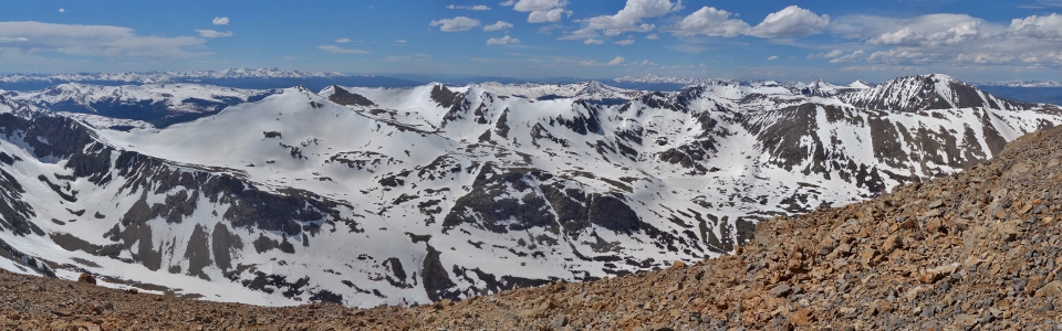
While Mount Cameron was the most dubious of the day's summits, it was, IMO, the most spectacular. Great lighting helped, no doubt, but this 14er-filled panorama stretching from Mount Democrat (left) to Quandary Peak (right) proved to be my favorite of the day! Click to see larger.
.jpg)
From left to right (foreground): Mount Buckskin, Mosquito Peak, Treasurevault Mountain, Mount Tweeto, Mount Democrat and Mount Arkansas.
.jpg)
Some 38 km away, Mount Elbert (center) rises above every other peak in the Rocky Mountains.
.jpg)
Even the famous (and lovely looking ) Maroon Bells (center right) were visible over 80 km to the west. You can write off the "summit" of Mount Cameron but you can't write off its summit view!
.jpg)
Life is good! Posing for a more successful 10 second timer selfie with Buckeye Peak (center left), Traver Peak (center) and Clinton Peak (center right).
.jpg)
Even if its "holy cross" is not apparent from the Mosquito Range, the Mount of the Holy Cross (center) most certainly is.
.jpg)
Still snowbound valleys to the north below Clinton Peak (left), Wheeler Mountain (center) and Fletcher Mountain (center right).
.jpg)
Snow dunes visible on the surface of a still-snowbound Wheeler Lake far below.
.jpg)
To the northeast, Quandary Peak (left), Mount Lincoln (center) and Mount Silverheels dominate the panorama. Click to see larger.
.jpg)
14er Quandary Peak.
.jpg)
Front Range 14ers Torreys Peak and Grays Peak make a cameo appearance over 40 km beyond the left shoulder of Mount Lincoln. Grizzly Peak D (the site of yesterday evening's adventure) is just out of sight one peak to the left of this frame.
.jpg)
Of the Lincoln/Cameron/Bross trio, Mount Lincoln is, by far, the most aesthetic which is fitting given that it's the high point of the Mosquito Range.
.jpg)
14er Mount Evans is just visible immediately to the right of Mount Lincoln.
.jpg)
A better look at Mount Silverheels and the altiplano which separates the Mosquito Range from the more easterly Front Ranges.
.jpg)
A final look back towards Mount Bross' forbidden summit before continuing on with the day's adventure.
.jpg)
Onwards and downwards (a whopping 42 m) towards the Cameron - Lincoln saddle.
.jpg)
From the saddle, a well-defined trail leads skywards towards the apex of the Mosquito Range: Mount Lincoln.
.jpg)
One of many abandoned mine sites that I passed. If the mine owners can bar access to peaks, surely they can be held to account to clean up their refuse once done?
.jpg)
From a distance, Mount Lincoln looked like it might present the day's greatest challenge but, as I neared, its summit block looked less and less fierce.
.jpg)
The extent of the "scrambling" on Mount Lincoln's summit block - a class 2 walk-up at most!
.jpg)
I guess this is the summit...
.jpg)
If the survey marker didn't make things evident enough, this stunning summit panorama to the south made it quite apparent that I'd reached the high point of the Mosquito Range. Click to see larger.
.jpg)
Beyond Mount Lincoln's steep south face, Mount Cameron looks mountain-like enough for me (prominence isn't everything, right?).
.jpg)
To the west: a host of snowy summits (that I've already identified from my Mount Cameron summit photos!). Click to see larger.
.jpg)
Batting 0.667 on my 10 second timer summit selfies.
.jpg)
Wheeler Mountain (center left), Fletcher Mountain (center) and Quandary Peak (center right) ... again. Multiple summit traverses are great but, even, I must admit that the summit views start to look a lot alike by then end!
.jpg)
Thanks to an uncharacteristically late summer, the snow-capped peaks made for a very scenic late-June summit but it would be nice to see Wheeler Lake thawed amidst, presumably, green alpine meadows. Perhaps my boss will send me to Colorado again next June?...
.jpg)
As the afternoon became early evening, clouds began to accumulate leading to sun-splashed panorama to the east. Click to see larger.
.jpg)
Red Mountain (left), Mount Silverheels (right) and the Montgomery Reservoir to the east.
.jpg)
A final look back towards the forbidden peak from whence I came before heading down.
.jpg)
On the way from Cameron to Lincoln, that 42 m loss seemed inconsequential but on the way back that 42 m gain seemed less -so (though perhaps that's just the altitude speaking)!
.jpg)
Traver Peak's isosceles east face was a pleasant companion as I descended Mount Cameron's west ridge towards the Cameron - Democrat col.
.jpg)
All day-long, Mount Democrat looked snowy and intense. As I neared the saddle to its east, however, it began to look less-formidable. Even so, with the hour drawing late and a longer drive back to Denver, I decided to be uncharacteristically sensible and to call it a day after "only" three 14000-foot-tall summits.
.jpg)
Looking back down the Kite Lake Valley from the Cameron - Democrat saddle. A section of the regular trail is visible below but it doesn't take full advantage of this year's uncharacteristically abundant snowpack...
.jpg)
Readying myself for the best part of my day: a (literally) cheeky 400 vertical meter glissade!
.jpg)
Moments later, with a wet bottom, I was gleefully looking back up at a tremendous a$$bogganing slope!
.jpg)
Boot-skiing down a more mellow snowfield near Kite Lake (I swear it's under that snow somewhere!). While this part of the day could have gone seriously sideways, the snow was still, mercifully, supportive and I only post-holed for the last 5 - 10 steps before stepping back onto dry meadow below.
.jpg)
As I walked down the Kite Lake Road, a plow went in the opposite direction. Another few days of this heat and some more plowing and compact "SUVs" like my rental might even be able to make it to the trailhead! Until then, however, I was still stuck walking 1 km back along the road to my econo-rental.
.jpg)
Of course, there are worse things than walking back...about 100 m from where I parked, I stumbled upon this ACTUAL SUV quite completely stuck. Despite my fatigue, I tried to help as best I could; be it the ol' Canadian push, digging, letting air out of tires or placing rocks under his wheels. When none of the above worked, the driver asked if I'd bring my little rental up the road so he could use his winch to pull himself out. Given that his suburban assault vehicle had dug itself into a predicament, I figured that my compact was unlikely to fare better and told him as much. I also told him that he could walk 1 km up the road to find a plow that would surely come to his aid. He seemed appalled at the idea of walking 1 km and, instead, returned to his vehicle and kept on with his strategy of "gun it and hope for the best." I, on the other hand, hiked back along the last 100 m of road towards my dry parking spot. After driving almost all the way back to Denver, I found a lovely taproom to gain back all the calories that I'd lost (cheese steak FTW!) and wondered if that poor dolt was still digging himself deeper into the snowbank. As I enjoyed a well-earned NEIPA, I reflected back on the 8 summits I'd managed to tackle over the past 3 days with a deep sense of satisfaction and wondered what tomorrow (the last day of my Denver trip) would bring.
As they say, go big or go home!...
.jpg)
.jpg)
.jpg)
.jpg)
.jpg)
.jpg)
.jpg)
.jpg)
.jpg)