Next to the many larger peaks of the Castle Mountain massif, Helena Ridge’s East Peak appears to be little more than a rocky bump. At over 2,500 m elevation, however, this peak is far from diminutive! Moreover, the views that its summit offers rival those of any of the massif’s larger peaks. Until recently, however, Helena East literally existed in the shadows of its loftier neighbors. A small cairn on its summit suggests that it was occasionally visited but, of the hordes that hike to Rockbound Lake or scramble up Castle Mountain/Stuart Knob/Helena Ridge, few seemed to even notice Helena East.
All of that changed in February 2019, however, when Matt Clay posted a snowshoe trip report. Matt’s photos were spectacular and his route appeared to generally avoid avalanche terrain. The internet noticed and, soon, the rush of copycat ascents was on! Suddenly, this previously unheard-of outlier was “the world’s most popular peak.” Generally, I disfavor copycat ascents. I prefer to lead not follow. Having said that, all the cool kids were doing it…
After succumbing to peer pressure (and the myriad lovely photos that littered my social media feed), I managed to convince Dr. Phil (no – not that Dr. Phil) to join me for a Friday ascent of Helena East. Like me, Phil claimed that he wasn’t keen on copycat ascents but, suspiciously, didn't put up much of a fight when I suggested Helena East as our target.
Phil and I literally have a history of spectacular failure together. The only time we’d ever met was one of the most amazingly scenic days that I’ve ever had but it ended without the summit that we both coveted. In the 2.5 years since, we’ve messaged dozens of times but somehow always been unable to make plans stick. Even in the week leading up to this outing, a couple of injuries, a bout of vomiting and a sudden work emergency nearly thwarted our plans. Finally, as our Friday off approached, another obstacle reared its ugly head; unseasonably warm March weather sent avalanche forecasters into a tizzy and a “Special Avalanche Warning” was issued for all regions of the Canadian Rockies. I’ve never ventured out in “High” avalanche conditions but, as Phil pointed out, “High” is still better than “Extreme.” We were both pretty desperate to get out so we figured we’d give it a go, taking special care to avoid questionable terrain. If we couldn’t find a safe way up Helena East, we’d just turn around. Given our history, we figured that a failed summit bid could at least be part of, what was shaping up to be, a spectacular day!
.jpg)
Here we go again… After 3 previous trips each up the plodding Rockbound Lake trail, Phil and I both swore we’d never return. Funny how that worked out! Fortunately, the combination of supportive morning snow and good conversation made us largely oblivious to the trail’s tedium. Energized by brilliant blue skies and warm sunshine, our hike up the packed trail seemed to pass remarkably quickly. This would, of course, average out on descent when the same trail seemed to stretch on ad inifinitum.
.jpg)
Phil enjoys the still mountain air as the Eisenhower Tower finally comes into view. By this point, we’d put 5.2 km and 530 vertical m of uninspiring trail behind us. Excited by the adventure to come, however, this distance felt like nothing at all.
.jpg)
The trail to Rockbound Lake begins with a pair of never-ending switchbacks. After the second switchback, the trail turns sharply to the west and makes its way towards the basin between Castle Mountain and Helena Ridge. About 300 m after the trail veers westward, we saw the (now obvious) ‘shoe track branching off to the north across snow-covered Silverton Creek and towards Helena East. We also caught our first glimpse of the objective itself through the trees. The safest line up Helena East loosely follows its gentle southwest ridge (mouse over for approximate route).
.jpg)
As we followed the well-established track, we soon reached the same gully feature that others reported ascending. While it would have been easiest to follow the ‘shoe track into this gully, Phil and I opted to avoid this obvious terrain trap given the current avalanche danger.
.jpg)
Fortunately, we found a relatively low-angled ridge to ascend to the climber’s right of the gully. Unfortunately, this meant that we were no longer following in everyone else’s footprints and that we (read: Phil) now had to take on the strenuous task of breaking trail.
.jpg)
Crux stops to catch his breath (a common occurrence for all amidst the waist-deep sugar snow that we were attempting to swim uphill in).
.jpg)
I really can’t thank Phil enough for taking the lead through the worst of the day’s snow. In addition to packing it down for Crux and I, his misplaced optimism provided some much needed levity! Every time that he failed to sink to at least his knees, he’d cheerily and excitedly remark: “The snow is finally getting better!” This of course set him up brilliantly for the face-plant into waist-deep snow that inevitably followed (often only a single step later)!
.jpg)
As we neared tree line, we eventually intercepted the established ‘shoe track above the gully. Excitedly, we followed it upwards into the alpine.
.jpg)
Breathtaking views (like this one over Castle’s shoulder towards Vermilion Pass) unfolded behind us as we continued up increasingly open, but still gentle, slopes. As my energy waned somewhat, I was happy to have such sights since they provided a good excuse for frequent “photography” stops! Even the indefatigable Dr. Phil must have been feeling the effects of trail-breaking as he also stopped often to delight in the patterns that the strong March sun (and an erstwhile skier or two) had carved into the snow’s surface.
.jpg)
An impressive outlier of Helena Ridge rises dramatically above the (somehow) still-golden larch forest.
.jpg)
Large cornices cling to their lofty perches above.
.jpg)
Crux and I tackle the final open slopes below Helena East’s summit ridge. On ascent, we followed the main ‘shoe track which continued directly above us. These slopes were generally benign, however, 1 or 2 brief rolls were steep enough to prompt us to alter course slightly in an attempt to avoid convexities. On descent, we plotted an even more conservative course and made our way down gentler slopes on the right of this photo. Photo courtesy Phil.
.jpg)
As we reached the summit ridge, we were greeted by splendid Sawback scenery! Click to see larger.
.jpg)
Crux and I pause to enjoy the spectacular views as we continue up along the corniced ridge. Photo courtesy Phil.
.jpg)
The final scenic stretch towards Helena East’s broad but spectacular summit (right).
.jpg)
Dramatic outliers of Helena Ridge tower above Helena’s smaller East Peak. As impressive as these peaks are, they’re still lower than Helena’s true summit which is out of sight some 3 km to the west!
.jpg)
About 5 hours after we set out, we finally reached Helena East’s small summit cairn, proving that we aren’t jinxed when it comes to summit bids. Indeed, we appear to be batting .500 now!
.jpg)
Helena East’s summit provides wonderful views of Banff National Park’s Sawback Range. Given the Range’s proximity to the Bow Valley and TransCanada corridor (right), it’s surprising that many of these jagged peaks are unnamed. Click to see larger.
.jpg)
A host of unnamed Sawback summits rise above the Johnston Creek Valley to the north. Of all the peaks in this photo, only the distant pointy peak on the far right (Noetic Peak) has an official name. I’ve seen some other online reports that mention Block Peak, however, I believe that the view of Block is, effectively, “blocked” by the large outlier of Noetic in the center of the photo.
.jpg)
Nameless splendor. Certainly makes identifying peaks an easy task! As near as I can tell, the only named peak visible here is distant Mount Aylmer (center right horizon). The very large and jagged peak at center is listed only as “Sawback Range” on government topo maps.
.jpg)
To the southeast, the Sawback (left) and Massive (right) Ranges bookend the Bow Valley beyond Helena East’s corniced summit ridge. Click to see larger.
.jpg)
Mystic Peak (center left) is a rare creature indeed: a named Sawback summit!
.jpg)
Closer to the TransCanada Highway, the official names start to come fast and furious! Mount Ishbel is the spectacularly pointed peak at center left while Cockcomb Mountain (distant center) and double-summited Mount Cory (right) are also apparent.
.jpg)
A closer look at the TransCanada Highway as it winds its way east to Banff. Like the Sawback Range, the Sundance Range (center left) is largely unnamed. Indeed, this 24 km-long collection of peaks features, to my knowledge, only 4 named summits including snowy Beersheba Peak at center. To the center right, distant Mount Sir Douglas can be seen while Old Goat Mountain is the impressive peak in the distance on the left.
.jpg)
With summit views like this, it’s hard not to smile. Fear not though! That smug smile would eventually be wiped from Phil’s face when it came time to plod back down the soul-destroying Rockbound Lake trail…
.jpg)
The southern panorama features the Massive (left) and Ball (right) Ranges. Castle Junction can also be seen in the Bow Valley below (right). When I set my sights on Helena East, I was convinced that the most spectacular peaks would be in this direction. They are, after all, the biggies along the Continental Divide. This angle, however, doesn’t really do them justice. Click to see larger.
.jpg)
Mount Bourgeau (left), Pilot Mountain (center) and Mount Brett (right) form the heart of the Massive Range beyond some impressive cornice scenery. In this distance, mighty Mount Assiniboine (center left) also makes a cameo appearance.
.jpg)
Pilot Mountain (left) and Copper Mountain (right) bookend the high alpine meadows that surround Healy Pass (center). Beyond Healy Pass, the Monarch and much smaller Monarch Ramparts can also be seen.
.jpg)
Haiduk Peak (center) stands tall over the Egypt Lakes area to the south while distant Mount White Tail (right) appears through Ball Pass.
.jpg)
Massive Mount Ball is the unquestioned king of the area...
.jpg)
…though Storm Mountain also presents a compelling case.
.jpg)
Obligatory On-Top summit shot with Castle Mountain (right). The large rocks that poked through the snowpack here and there provided good places to pose without having to worry about falling through a cornice!
.jpg)
Beyond Castle Mountain, Highway 93 South crests the continental divide at Vermilion Pass before meandering on towards Radium Hot Springs.
.jpg)
Distant Hewit Peak (left) Tumbling Peak/Mount Gray (center) and Mount Whymper (right) tower beyond Vermilion Pass.
.jpg)
Crux enjoys a well-deserved summit snooze in the shadow of Helena Ridge’s impressive subpeaks.
.jpg)
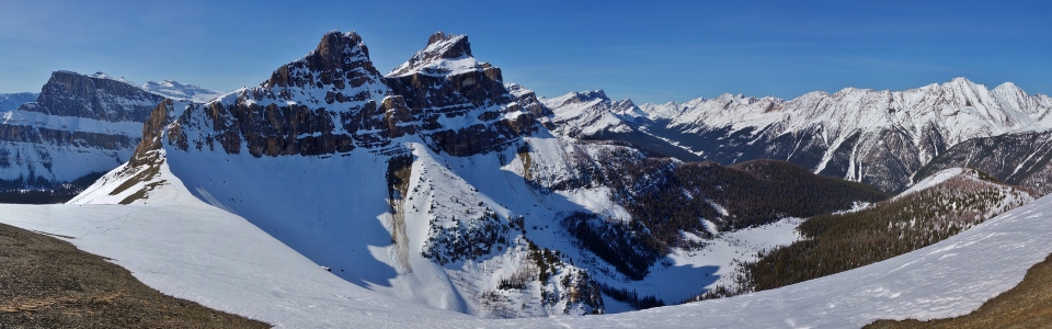
With peak-filled panoramas in every direction, Helena East is a fine snowshoe objective but the spectacular western panorama towards the Castle Massif’s larger peaks really sets it apart as a jewel! Click to see larger.
.jpg)
Proof that the avalanche forecasters weren’t wrong…this impressive slide ran all the way to ground (and it was far from the only one)!
.jpg)
Helena Ridge’s spectacular subpeaks highlight the view northwest along Johnston Creek.
.jpg)
A closer look at the real show-stealer.
.jpg)
Pulsatilla Mountain (left) stands tall over Pulsatilla Pass (center) at the headwaters of Johnston Creek. Beyond the pass, Cyclone Mountain is also apparent.
.jpg)
The Sawback Range features only a single named peak (Hickson Peak on the distant center left) to the north of Noetic Peak (distant center right). Click to see larger.
.jpg)
Sun, snow and smiles atop Crux’s 80th different peak!
.jpg)
Chronicling a spectacular success with a group summit shot.
.jpg)
After a lengthy summit stay, all good things had to come to an end and Crux and I started our descent from Helena East’s scenic summit. Photo courtesy Phil (who eventually grew weary of my non-stop summit photography and started down ahead of us).
.jpg)
After catching the speedy doctor, we set off down the gentlest slopes that we could find together.
.jpg)
As the afternoon grew late, the hot sun beat down relentlessly turning the snow into a wet, heavy mess. As we descended, our steps frequently produced localized settlements as the heavy, wet surface snow collapsed on the airy, unsupportive sugar snow that lay beneath it (mouse over to see one of the many we left behind). Fortunately, these never propagated since the slopes were, largely, too gentle to slide! Even so, we very cautiously plotted our course avoiding any rolls or high consequence terrain.
.jpg)
The best part of the day! Not wanting to part from this peak, I insisted that we stop for another break at tree line where we enjoyed an invigorating late afternoon tea while soaking in the scenery and sunshine.
.jpg)
Once we’d had a proper afternoon tea, we resumed our descent post-hole-a-thon down through the trees, using our up-track to avoid the scenic terrain trap gully once more. Thanks to the amazing weather, we sank even deeper (and, surprisingly, more frequently) on descent than we had on the way up. Whenever we didn't sink, we slipped as the teeth on our snowshoes failed to find purchase on the snow's slushy surface. Of course, this only marked the beginning of the suffering that was soon to come…
.jpg)
Having seen firsthand how weak the snowpack had become, Phil cautiously tiptoed across snow-bridged Silverton Creek. Like any good friend would, I stood back, camera in hand, hoping that he’d fall through…
.jpg)
But alas, his slender frame only weakened the snow bridge! Despite a recent diet, it was left to me to utterly destroy it. Mouse over to see a suddenly wet Matt. Photos courtesy Phil who was good enough to document my unplanned bath.
.jpg)
They say that “all’s well that ends well” but that’s not true of Helena East. It’s still well – spectacular even. BUT IT DOESN’T END WELL. It ends with a mind-numbing plod down the Rockbound Lake trail’s 2 never-ending switchbacks. We’d both previously sworn not to do this to ourselves but here we were (again). Phil’s an accomplished long-distance runner and no stranger to LONG days in the mountains so I was quite surprised to find him bitching as much as I was. That’s probably a true testament to the Rockbound Lake trail’s FML character. It really put the "hell" back in "Helena." As my sighs of despair echoed off Castle Mountain’s impressive cliffs (which can’t even be seen from this God-forsaken trail despite the fact that it passes right under them), I swore that I would never hike this trail again…
Oh who am I kidding? I’ll be back. Sigh.
As Phil noted, “memories of that trail will fade as we marvel at the lovely photos we got of a superbly sunny, warm, windless day.” A day that will, no doubt, be the highlight of my winter mountain adventures this year.
.jpg)
.jpg)
.jpg)
.jpg)
.jpg)
.jpg)