In recent years, my job has forced me to take on more work-related travel. In theory, getting paid to visit new places sounds great. In practice, it doesn’t always work out so well. For every interesting trip that I’ve been sent on, there’s been a less interesting one to Indiana or the City that Fun Forgot (Toronto). I know, “woe is me”, right? When my boss told me that he wanted me to attend some June meetings in Denver, however, my heart skipped a beat. For me, it doesn’t get much better than a summer trip to the Rocky Mountains (be they American or Canadian – I don’t discriminate). Of course, I’d need to get my work done but the days are pretty long in late June. Perhaps I could sneak in an after-work peak or two?...
.jpg)
With meetings scheduled on Tuesday morning, Monday was always going to be a travel day so I booked myself an early flight to Denver. The gentleman who sat next to me on the plane said he’d never seen anyone working so hard on a flight. Despite the phenomenal views out the plane’s window, I was doing my damnedest to take care of my Monday tasks and prep for my Tuesday meeting before landing. Once on the ground, I had other plans...
.jpg)
After landing at 10:30 am, I was in a rental car and on my way to Boulder, CO within an hour. Boulder is about 40 minutes north of Denver and home to the world-famous Flatirons. Although I’m not a climber, I figured that, as a mountain enthusiast, I owed it to myself to see this climbing mecca while in Colorado. My quick Google search of the area also revealed that Bear Peak stood immediately south of the Flatirons and featured a relatively short 8.5 km out-and-back trail to its summit (hmmm…). After loading up on Cliff Bars and apples at the local grocer, I made my way to the large hiking trailhead at the National Center for Atmospheric Research (NCAR) and set out to tackle my first Colorado Rocky!
.jpg)
A trailhead sign reveals a plethora of hiking options. Despite the detailed map (which I even took a photo of for ease of reference), I’d still manage to get myself briefly lost. When a climb involves complex route-finding, I have no issues but put me on a marked approach trail and I’m bound to get lost!
.jpg)
Spectacular views of the Flatirons only moments from the trailhead parking lot.
.jpg)
A closer look at the Third (center) and Second (center right) Flatirons from the Walter Orr/NCAR trail. I can certainly see the allure that these sandstone features would have for climbers.
.jpg)
While the Flatirons provided a feast for the eyes to the north, Bear Peak looked just as appealing to the south.
.jpg)
Hiking through beautiful pine forest early on.
.jpg)
The sign that almost got me lost about 30 minutes from the trailhead. With Bear Peak as my destination, it seemed reasonable to follow the sign for Bear Canyon, no? As I set off on the Bear Canyon trail, however, things just didn’t feel right. For one: I was now losing elevation. For two: I was now hiking away from Bear Peak. Usually, things like that are dead giveaways but I assumed that the trail would descend to the canyon and then turn back around and re-ascend. After walking a couple hundred meters, however, my peak-bagging senses began to tingle and I (fortunately) decided to do an about-face. As I did, I ran into another hiker who was in a similar quandary so apparently it wasn’t just me!
.jpg)
What goes down the wrong trail must go back up – at least I’m headed towards my objective this time!
.jpg)
Stopping to smell the flowers – in this case, a wild rose. I probably should have done more of this on my way up Bear Peak but, for some reason, I felt compelled to bust my ass up this peak (despite the fact that my energy levels weren’t keeping up with my ambitions). I think the “get it all done ASAP” attitude that I’d adopted for my work on the plane carried over and set the tone for everything else on this day.
.jpg)
About 10 – 15 minutes above the confusing sign, I reached the correct turn-off for Fern Canyon (the steepest and most direct route up Bear Peak).
.jpg)
The Fern Canyon trail certainly lived up to its “short and steep” billing and had me huffing and puffing in the afternoon heat.
.jpg)
Fern Canyon featured a number of beautiful rock features that begged for some exploratory scrambling. Most of these were, however, within a seasonal wildlife closure intended to protect nesting raptors (!).
.jpg)
More off-limits but tantalizingly climbable rock at the top of Fern Canyon near the col to the north of Bear Peak.
.jpg)
Colorful wildflowers and fantastic Flatiron views from the saddle to Bear Peak’s north. Having busted a gut on the hike up Fern Canyon, the saddle provided a scenic rest stop to enjoy my adlibbed lunch. Sadly, the consumption of food did little to alleviate my woeful energy levels and, instead led to a solid case of ETAP.
.jpg)
After my repast, I followed the well-established but steep trail on Bear Peak’s north ridge. As my sides ached, I took occasional rest stops. They didn’t seem to help but at least I got to enjoy the views of the larger (snowier!) peaks to the west as they opened up.
.jpg)
Iron-rich red rocks and twisted pines near the summit of Bear Peak.
.jpg)
A couple of other hikers tackle the final, exciting ridge to Bear Peak’s summit. The ridge is a little airy but actually looks worse than it is. In my opinion, it straddles the line between easy (class 2) and moderate (class 3) scrambling.
.jpg)
Enjoying a scenic (and slightly airy) perch on my first Colorado Rocky!
.jpg)
The summit panorama to the north featured fine views of the larger Indian Peaks to the west, Mount Green and the Flatirons to the north and Boulder below to the east. Click to see larger.
.jpg)
Arapahoe Peak (center) and Kiowa Peak (right) both rise to above 4,000 m elevation to the west.
.jpg)
Mount Audubon (center left) and Saint Vrain Mountain (center right) highlight the view to the northwest.
.jpg)
Longs Peak (center left) is one of 53 “ranked” 14ers in Colorado (a 14er being a peak whose elevation exceeds 14,000 feet/4,267 m).
.jpg)
The treed summit of Green Mountain rises directly above Boulder to the north. Green Mountain’s east slopes are home to the famous Flatirons I’d come to see. When I first looked into hikes, I intended to ascend Green Mountain (since it is properly the summit of the Flatirons) but opted instead to hike Bear Peak when I discovered that Green Mountain’s summit view was marred by trees.
.jpg)
A closer look at Boulder, CO. The funky looking NCAR building where my rental car was parked is visible atop a foothill in the immediate foreground.
.jpg)
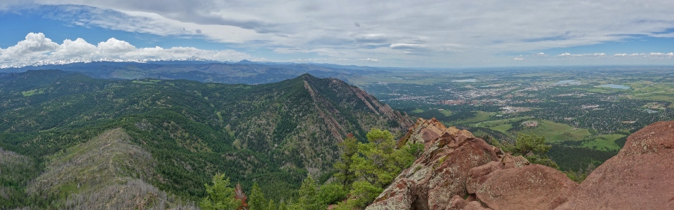
The southern panorama featured lush green prairies to the east, a host of smaller front range peaks (including nearby South Boulder Peak) to the south and more snow-covered giants to the west. Click to see larger.
.jpg)
Lichen and iron make for a colorful combination on Bear Peak’s summit ridge where a gap in the rocks frames the Denver skyline.
.jpg)
A closer look at “the Mile High City”: Denver, CO.
.jpg)
As I enjoyed the sights from Bear Peak, I couldn’t help but notice that nearby South Boulder Peak looked to be a tiny bit higher. Although I could have Googled its elevation to find out for certain, I figured it would just be easier to hike over and see for myself…
.jpg)
Mount Evans (another 14er) makes an appearance immediately to the right of South Boulder Peak.
.jpg)
Looking southwest towards James Peak.
.jpg)
It looks like ski season is over at Eldora but you might get some use out of those snow sticks a bit further to the west still…
.jpg)
Another hiker carefully makes his way up towards Bear Peak’s airy summit. Having enjoyed the summit for about 20 minutes, I decided that his arrival was my cue to leave. After all, I now needed to check out South Boulder Peak’s nearby summit to see which was higher!
.jpg)
Following another well-established trail through a recent burn towards South Boulder Peak.
.jpg)
Views towards Denver from the wildflower-littered Bear Peak – South Boulder Peak saddle.
.jpg)
Aptly named bluebells.
.jpg)
Less than a kilometer from Bear Peak, South Boulder Peak rises only 100 vertical meters above their shared col. This little add-on, therefore, provides a rather cheeky two’fer. Once you’ve gone to the effort of hiking up one, you may as well tackle the other!
.jpg)
The similar (but slightly different) summit panorama from South Boulder Peak. South Boulder Peak did prove to be marginally taller than Bear Peak (as Google could have told me anyways) but Bear Peak’s summit definitely offered the superior view. Click to see more of the same (but slightly different) in more detail.
.jpg)
Nearby Eldorado Mountain (left) and Crescent Mountain (right) highlight the view to the south. The actual highlight of the summit view was a soaring eagle but I wasn’t quick enough to snap a photo of him!
.jpg)
The still-snow-covered Indian Peaks rise up beyond a sea of verdant foothills to the west.
.jpg)
After hopping across a pile of wobbly boulders for this 10 second timer selfie, my camera opted to focus on the rocks in the foreground. Oh well…good enough!
.jpg)
After enjoying a quick snack atop South Boulder Peak, it was time to head back towards Bear Peak (center) and, ultimately, down. I’d hoped to enjoy a video call home to my girls while traversing between these peaks but cell phone service, unfortunately, cut out at the saddle.
.jpg)
Ugh. A knee-jarring descent from Bear Peak (and this would only get worse back in Fern Canyon). There are longer, more pleasant ways down from Bear Peak and South Boulder Peak but I opted to retrace my steps on the most direct route in the hope of connecting with my girls via video call before they went to bed for the night. Fortunately, the combination of anti-inflammatories and hiking poles allowed for a relatively speedy descent.
.jpg)
Back to Fern Canyon and ready to make full use of my hiking poles. Remarkably few of the local hikers that I ran into used poles. Given the speed with which I passed them on descent, they might want to reconsider!
.jpg)
Passing a lovely creek near Bear Peak’s foot. With temperatures uncomfortably high for a Canadian (30 C!), it felt amazing to dunk my head under this refreshing cascade.
.jpg)
A twisted pine and some rolling hillsides near the trailhead provided a lovely place to video-chat with my girls thanks to sudden cell phone reception. After warming my heart with their little smiles (and no doubt annoying the other hikers around me), I said my goodnights to them and continued (sadly uphill) for the final stretch back to the trailhead.
With my presentation for the next day’s meeting complete and 2 peaks in the bag, this proved to be one of my most “productive” work travel days ever! Best celebrate (and rehydrate) at the nearby Mountain Sun brewpub (where I was pleased to learn that your first Mountain Sun beer is on the house)!
Cheers!
.jpg)
.jpg)
.jpg)