"Waaah! Waaah!" My infant daughter's cries echo through our house. My amazing wife dutifully slips out of our warm bed and makes the familiar walk to our little girl's room in the pitch dark. As she comforts our baby girl, a glance towards the alarm clock reveals that it's 3:30 am. Sadly, this is the norm. I close my eyes and try to fall back to sleep.
It's no use. I'm awake. As I lay in bed, the compulsive peak bagger in me also stirs. If I'm up this early, why not make the most of it? The weather forecasts don't look promising but they suggest an outside chance of sunny skies until about 9 am. No point letting an alpine start and a possible early morning weather window go to waste!
I sneak out of bed and tread lightly as I ready my gear; I (correctly) suspect that my amazing wife will not see the brilliance of my current plan. Avalance.ca lists the danger today as "considerable." Best stick to conservative terrain.
"Waaah! Waaah!" More crying...except this time, it doesn't sound like crying. This time it sounds like a suggestion. Wawa. Wawa Ridge. I have my target!
.jpg)
Thanks to my early morning "wake up call", I arrived at Sunshine Village before the hordes and was treated to rock star parking right next to the lower gondola terminal. Given the forecast avalanche hazard, I reasoned that an ascent of Wawa Ridge via the Sunshine ski resort would be safe. 80% of the route is on avalanche-controlled ski runs and the final "out of bounds" south ridge to the summit is too low-angled to slide.
Under the hum of the deserted gondola, I put on my skinny cross country skis and set off up the ski-out's fresh corduroy snow. No easy ride up for me. Afterall, to employ such a conveyance would not constitute bagging a peak by fair means!
.jpg)
Mount Bourgeau and the popular Bourgeau Left ice climb catch the day's first rays as I sweat my way up the ski-out.
.jpg)
Empty gondola cars float effortlessly uphill, taunting me! Having not been up any peaks in the Rockies for over 3 months, I found myself huffing and puffing. The Sunshine ski out never seemed this difficult during my prior downhill ski trips here! Still, despite the strain of the ascent, I pushed my pace motivated by the (for now) clear blue skies overhead. Knowing that these were unlikely to last long, I skied up as fast as I could hoping to summit during the brief forecast weather window!
.jpg)
About halfway up the ski-out, my objective revealed itself. Some of Wawa Ridge's steeper slopes are fodder for backcountry and slackcountry skiers, however, my route up will be a winding one via resort runs and the mellow south (left-hand) ridge.
.jpg)
After 75 minutes and 5 km of hard work, I reached Sunshine Village, turned right past the Wawa chairlift and started up the ridge's green # 61 "Meadow Park" run. While I'd always found this name to be apt on downhill skis, the run seemed suddenly steeper as I cross-country skied up it!
.jpg)
Looking back towards Sunshine Village as I pause to catch my breath on Meadow Park.
.jpg)
As I climb, Mount Assiniboine comes into view framed by naked larch trees.
.jpg)
Looking past the ski resort's Great Divide chairlift towards (from left to right) Mount Assiniboine, Mount Nestor, Quartz Hill, Quartz Ridge and Simpson Ridge.
.jpg)
Twin Cairns appears ahead as the Meadow Park run veers to the west. Twin Cairns is close enough to Wawa Ridge to merit consideration as a two'fer, however, its steeper slopes present a greater avalanche risk.
.jpg)
A scenic and solitary moss-covered tree stump marks the apex of the Meadow Park run.
.jpg)
As the top of the Wawa chairlift (and the day's first downhill skiers) came into view, I reached a conveniently placed gate which allowed me to exit the resort's property without having to duck under the "Ski Area Boundary" rope. The gate also funnels backcountry traffic into one spot and I was, therefore, able to take advantage of a well-packed trail/up track for some time. A short distance beyond the gate, I ditched my skinny cross country skis (which don't fare well in deep snow) and donned snowshoes.
.jpg)
A picture perfect morning for a ski/snowshoe through the Sunshine Meadows (click to see larger)! Wawa's mellow south ascent ridge is obvious on the left while Goat's Eye's myriad ski offerings can be seen on the right. The south ridge itself presents no risk of sliding, however, Wawa's east aspect becomes steeper the closer one gets to the summit. It's therefore best to gain the south ridge as soon as possible after leaving the ski area.
.jpg)
Wandering up wonderfully wind-affected snow (no post-holing!) on Wawa's gentle south ridge.
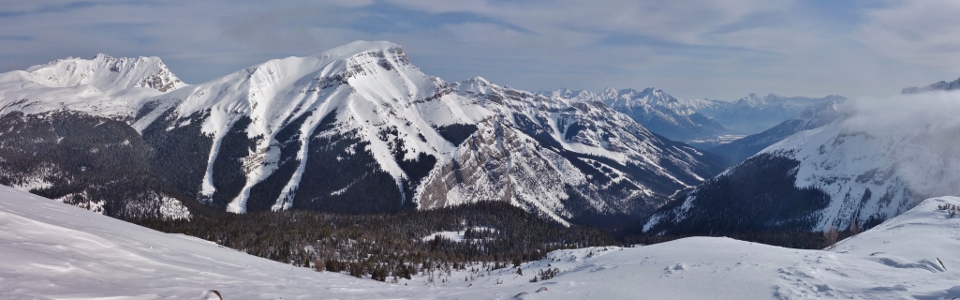
.jpg)
A spectacular panorama unfolds at my back as I make my way up the final ridge (click to see larger). As the clock struck 9 am, the good weather window for Wawa began to close and clouds started to pour over the nearby Great Divide.
.jpg)
After one final (slightly steep) slope, Wawa's summit is marked by a large cairn and a variety of communications and weather equipment.
.jpg)
Ski resort detritus on the summit. Wawa Ridge offers a line of sight to both the lower gondola terminal and the ski area proper likely making it a good place for radio equipment.
.jpg)
An improved summit panorama with the various bits of ski area infrastructure artfully cropped out! Click to see larger.
.jpg)
Mount Brett (distant) and its more proximate southeast subpeak (Black Brett).
.jpg)
On top before 10 am and enjoying the view towards Mount Bourgeau (left) and Massive Mountain (center right)... all thanks to my beautiful baby girl!
.jpg)
Looking northeast towards Banff which sits in the valley below Cascade Mountain (left), Mount Inglismaldie (center right) and Mount Girouard (right).
.jpg)
To the south, clouds continue to pour over the Great Divide as the fair weather window scenically slams shut. Click to see larger.
.jpg)
Taking a summit photo with "the Matterhorn of the Rockies" while it's still visible!
.jpg)
To the east, Eagle Mountain (left) and Mount Howard Douglas (right) account for most of Sunshine's skiable terrain (althought the resort erroneously calls them "Goat's Eye Mountain" and "Lookout Mountain").
.jpg)
A closer look at Mount Howard Douglas (true summit on the left).
.jpg)
Obligatory summit selfie.
.jpg)
A pair of visitors join me as I enjoy the rapidly whitening view towards the Monarch.
.jpg)
A rushing river of cloud overtakes the Monarch Ramparts and Healy Pass to the west.
.jpg)
Massive peaks of BC's Vermilion Range dramatically enveloped in swirling clouds. From left to right they're probably: Unnamed, Mount White Tail and Mount Verendyre (it's kind of hard to tell when you can only see their summits).
.jpg)
Mount Ball (left) presides over its namesake range to the northwest.
.jpg)
Storm Mountain (right) makes an appearance at the northern edge of the Ball Range.
.jpg)
A spectacular summit scene as clouds fill up valleys and the Sunshine Meadows disappear to the south, creating a short-lived but stunning inversion. Click to see larger.
.jpg)
Nearby Twin Cairns is battered by icy gusts as it begins to disappear into the rapidly rising inversion layer. By this point, the deteriorating weather made the prospect of a two'fer much less appealing and I began to contemplate my descent.
.jpg)
The clouds race upwards, obscuring all but the summit of the nearby Monarch.
.jpg)
Thanks to its near-11,000 foot elevation, Mount Ball continues to poke above the growing cloud cover...for now.
.jpg)
A final sighting of majestic Mount Assiniboine to the south. After enjoying the rapidly changing weather for 45 minutes atop Wawa Ridge, I too was enveloped in frigid whiteout conditions.
.jpg)
The sudden disappearance of everything and continued cold prompted me to start making my way down. Fortunately, I timed my ascent better than these ski tourers who arrived on top moments after the clouds overtook Wawa Ridge. I hadn't felt thankful when my baby girl woke me up at 3:30 am but found myself feeling that way as I gleefully plunge stepped down the now featureless terrain. If it hadn't been for my alpine start, I surely would have missed the morning's spectacular scenery!
.jpg)
Following a viewless descent, I soon returned to the ski area and donned my skinny cross country skis for what I hoped would be a fun ski down. Unfortunately, by this time, the morning's smooth corduroy snow had been replaced by carved ruts and piles of loose snow. On alpine skis, these present no issue, however, they proved a little challenging to navigate on hard-to-control, edgeless cross-country skis...still that lack of control didn't stop me from reaching speeds up to 40 km/h!
.jpg)
Enjoying the nearly deserted ski-out as I continue my more-rapid-than-normal descent. From time to time, downhill skiers flew easily past me, probably wondering who this amateur furiously snowplowing the whole way down was! Despite my slower relative speed, I still made it from summit to parking lot (without incident) in only an hour.
Following the consumption of some much-needed caffeine (I had, after all, been up since the middle of the night!), I made my way home where I was eager to see my baby girl. Upon being reunited, I was quick to thank her for the alpine start (and quicker still to thank my wonderful wife for watching both our girls while Daddy was off gallivanting among the clouds)!
.jpg)
.jpg)
.jpg)
.jpg)
.jpg)