Picketpost Mountain
Elevation: 1334 m (4378 feet)
Elevation Gain: 610 m (2010 feet)
Picketpost Mountain is the prominent remnant of a once-much larger volcanic feature. The mountain’s volcanic rocks have weathered into steep vertical cliffs, creating the appearance of an impregnable butte. The peak was named for a military encampment which existed at its base in 1870. Established by General George Stoneman during the Apache wars, this camp benefited from lookouts atop the mountain. Although the military camp was short-lived, the nearby town of Superior quickly grew following the discovery of silver and copper in the area.
My Ascents:
March 8 2018
Trailhead: Picketpost Mountain Trailhead
GPS Track: Picketpost Mountain
In the midst of Calgary’s coldest and snowiest winter in a generation, Brianne, Mera, Penny and I were even more excited than usual about our annual Arizona getaway. Adding to Brianne and I’s excitement was the built-in babysitting that comes along with our annual trip to see her snowbird parents! Having not been on a proper date in eons, we excitedly formulated our adult escape plans. With Penny still nursing, our date would need to be a speedy one. Fortunately, the girls’ grandparents live a short 35 minute drive from the Picketpost Mountain trailhead. After feeding the girls and very hastily researching the route up, we set off in ‘Papa’s’ generously donated-for-the-day truck and made our way to the well-marked Picketpost Mountain trailhead just east of mile marker 221 on highway US 60.
.jpg)
Picketpost Mountain rises dramatically above the surrounding desert floor from the trailhead. When we set off from her parent’s house, I’d informed Brianne that Picketpost was a small mountain (which it is by Rockies standards). Upon seeing it from the trailhead, however, she took exception to my definition of ‘small’ (apparently size does matter to my wife)!
.jpg)
From the trailhead, the route follows the relatively flat Arizona trail for about 1 km (1/2 mile) before splitting at a well-signed fork. From here, the going soon becomes much steeper. The initially well-established trail deteriorates into a series of loosely connected paths which become somewhat difficult to follow. In general, however, the route follows a rib up towards the prominent draw which separates the 2 high points visible in this photo. This draw breaches Picketpost’s formidable walls, eventually granting access to its broad summit plateau.
.jpg)
Saguaros and boulders highlight the surrounding desertscape.
.jpg)
As the rib at Picketpost’s foot reaches its steep walls, the route becomes more hands-on. Having only glanced at a route description beforehand, we were both somewhat surprised at the sustained moderate/class 3 scrambling involved.
.jpg)
Thanks to some digital wizardry, a pair of Briannes show the way up the draw’s steep, water-worn rock. We were led into the draw at this point by a large cairn, however, easier ascent options exist out of sight to the climber’s left; we would use these on descent and find that they were well-cairned as well. As always, a cairn only means that someone else went that way…not that it was the smartest way to go!
.jpg)
Steep scrambling in the draw. I didn’t mind the moderate scrambling on smooth rock here but, at my wife’s request, we avoided it on descent.
.jpg)
Eventually, we escaped the increasingly steep, smooth terrain in the draw and found a decent path along ledges just above its north (climber’s left) side. Faded arrows (bottom left of this image) and cairns marked the path of least resistance here but multiple ascent options existed.
.jpg)
Brianne pauses to take in the panorama (click to see larger) after route finding her way up the steepest section. From here, the summit plateau is within striking distance (although the summit proper is, discouragingly, on the far side of it).
.jpg)
Making her way out of the draw and onto the expansive summit plateau.
.jpg)
The Superstition Mountains make for a lovely backdrop as Brianne hikes across the suddenly-flat terrain towards the summit on Picketpost’s south side.
.jpg)
This oddly placed mailbox makes the summit of Picketpost Mountain impossible to miss.
.jpg)
As you’d hope, the summit mailbox comes complete with a backstory:
“TRUE HISTORY OF THIS BOX: RESIDED FOR YEARS AT 9843 HAMMER RD. LINDEN, WASH. 98264. ONCE BARRELED OVER BY A GREEN, GREEN JOHN DEER TRACTOR, DRIVEN BY AN EAST INDIAN. REPAIRED AND REPLACED ON SEPT. 10, 1994 WAS NEARLY DISTROYED BY A WHITE CHEV. 1978 SEDAN DRIVEN BY A DRUNKEN GUATEMALAN. WAS RETIRED, RESHAPED AND RELOCATED AT THIS SPOT WHERE IT IS BELIEVE TO BE RELATIVELY SAFE FROM EITHER.” (sic)
.jpg)
Brianne enjoys the beautiful view from an aptly placed summit bench.
.jpg)
The expansive southern panorama from Picketpost's summit. Click to see larger.
.jpg)
The town of Superior lies at Picketpost's eastern foot while King's Crown Peak (left), Fivepoint Mountain (distant center) and Apache Leap (right) highlight the eastern horizon.
.jpg)
The Alamo Canyon (and Arizona Trail) highlight the panorama to the south which stretches from Pinal Mountain (distant left) to Kitt Peak (distant right).
.jpg)
Distant Mount Lemmon rises up beyond the southern reaches of Alamo Canyon.
.jpg)
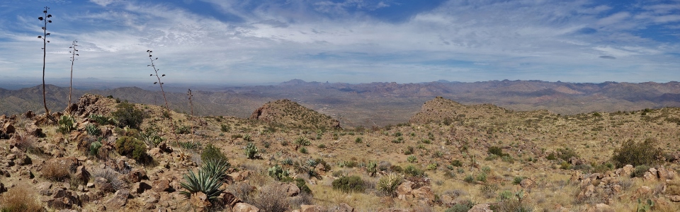
The panorama to the south and west. Click to see larger.
.jpg)
Mineral Mountain’s distinctive form (center left) is obvious to the west.
.jpg)
Looking north and west across Picketpost’s expansive summit plateau. To the left, the greater Phoenix area is obscured by desert haze while the Superstition Mountains highlight much of the remaining panorama to the right. Click to see larger.
.jpg)
Superstition Mountain (left) and Weaver’s Needle (right) are unmistakable to the northwest.
.jpg)
Brown’s Peak and the Four Peaks Massif tower above all the other peaks visible to the north.
.jpg)
The happy summit couple on their first ‘proper date’ in some time! Alas, like all good things, the date would soon come to an end as we didn’t want to leave our baby for too long.
.jpg)
Retracing our steps down the scenic (and SPIKY!) summit plateau.
.jpg)
Brianne deftly avoids an unpleasant poke in the bum as we re-enter the draw, making our way back down towards the more interesting scrambling therein.
.jpg)
Carefully negotiating a waterworn ledge on descent. Although we were keen to get down to our waiting babies below, the descent obviously required care and ended up taking nearly as long to complete as our ascent did. About halfway down, we actually came upon a scrambler who sustained nasty looking injuries in a 15 – 20 foot fall! Fortunately, he already had a group of people attending to him and administering first aid. After confirming that our help was not required, we continued downwards (even more carefully than before).
.jpg)
Looking back up the steep draw at the terrain which required care to ascend and descend. By this time, the group assisting the injured scrambler had made their way about halfway down and are visible just above a large cliff in the center of the photo (mouse over for a closer look). From the peak’s foot, we quickly made our way along relatively easy trail and returned to the trailhead. Our kid-less date proved refreshing (if not tiring!) and we were soon on our way home looking forward to seeing our little girls once more!
.jpg)
Reunited with our loves! What better way to rinse off all that desert dust than a dip in the pool with the kiddos at day’s end? As always, thanks to “Nannie” and “Papa” for babysitting. As far as ‘proper dates’ go, Picketpost Mountain proved perfect!
.jpg)
.jpg)
.jpg)
.jpg)