Before becoming parents to 2 amazing (and sleep-depriving) daughters, my wife and I had all sorts of mountain adventures. Indeed, by my tally, we’ve stood atop nearly 80 different summits together. As regular readers will know, we’re still adventurous but our recent outings tend to be smaller-scale, more family-friendly affairs. Still, old habits die hard and when we asked for babysitting so that we could enjoy a date-day together, there was little doubt as to what kind of adventure Brianne and I were going to have: a mountain adventure, of course!
Wanting adventure, Brianne and I settled upon Gap Mountain in Kananaskis which promised to be a relatively quick day owing to its modest elevation gain (780 m) and round trip distance (5.2 km). With its ‘difficult’ rating, however, we knew the peak would keep us on our toes. We figured the peak would prove entertaining while still getting us home in time to relieve our babysitters.
.jpg)
Unfortunately, Gap Mountain (visible above Brianne) became adventurous much earlier than we’d anticipated. Mere meters from the trailhead parking area, we discovered a large pile of recently deposited bear scat. In the photo above, Brianne is actually poking it with a pole to evaluate its freshness!
.jpg)
A few meters beyond the fresh scat was an obvious bear closure. After examining the sign, we confirmed that the ascent route for Gap Mountain was just outside the closure area. Discouragingly, there was obvious bear poop on both sides of the tape. Obviously, the bear didn’t care to stay on his/her side of the closure…
After last week’s close ursine encounter, we were alarmed but, as yet, undeterred. We’ve been surrounded by bear sign on countless other mountains that we ascended incident-free. If we turned back every time that a bear pooped nearby, we’d summit very few peaks!
Of course, as we continued up Gap Mountain, the bear signs didn’t abate. In addition to (more!) poop, sections of the trail were very recently rototilled indicating that a grizzly had been at work. I examined the diggings closely and saw no boot prints in them (despite the fact that they were on the trail).
.jpg)
The final straw: bear poop so fresh that Brianne felt the need to check to see if there was still heat emanating from it! We don’t like turning around on a mountain but continuing up amidst so much fresh bear sign seemed folly. We’d been willing to ignore 5 or 6 red flags but by the 7th or 8th, we decided that it would be best to leave the (obviously) nearby grizzly bear in peace.
.jpg)
Cautiously retreating down Gap Mountain’s lush ascent gully. “Yo bear!”
.jpg)
Take 2: with options somewhat limited by the amount of time that our babysitters had agreed to stay and the amount of time we’d already spent on Gap Mountain, we made our way to the Fortress Junction Service Station to begin a lightning ascent of Opal Ridge’s South Summit. Having already climbed Opal South without Brianne a few years earlier, I knew we could be up and down it quickly and that the views would not disappoint. An easy scrambling, repeat peak wasn’t exactly the adventure I’d hoped for but sometimes you eat the bear and sometimes the bear eats you…
The Opal South trail starts by a “No Parking” sign in the northwest corner of the parking lot. This trail quickly ascends to a service road beneath power lines. After following this road north for a short distance and past a stream, the trail leaves the road, venturing uphill at a well-cairned junction. Thanks to cairns, stone arrows and logs blocking incorrect paths, the route is obvious. All of that still didn’t stop 2 young men who passed us from heading up a blockaded path which likely resulted in them having more of an ‘adventure’ on Opal South than we did!
.jpg)
Opal South may be easy scrambling but that doesn’t mean it’s easy! As you can see, the going is steep right from the get-go!
.jpg)
The Opal South trail(s) navigate a labyrinth of minor rock banks on the climber’s left, ultimately granting a pleasant ridge walk to the summit on the climber’s right. The route wasn’t quite the adventure that I’d hoped for but I (surprisingly) didn’t care all that much. Brianne apologized a couple times that we weren’t doing something more interesting (as though the bear on Gap Mountain was her fault!) but despite my habit of forsaking repeat ascents, I thoroughly enjoyed my Sunday afternoon on Opal South. As Brianne and I sweated our way up, I realized that the company of my date was what really mattered. :-)
.jpg)
Mounts Lawson (left) and Inflexible (right) make for a pleasant backdrop while my ‘hot date’ (literally and figuratively) tackles a more ‘scrambly’ step.
.jpg)
A pleasant Kananaskis Valley panorama from a grassy bench about halfway up (click to see larger). Also a great place to stop for a quick break! I’m not sure whether Brianne is enjoying the view, the break or the company more. I have a suspicion that it was one of the former though!
.jpg)
Higher up, the trail follows steep grassy terrain through the rock ‘gates’ at center right.
.jpg)
A preview of the pleasant ridge walk to come.
.jpg)
A pair of hikers (center left) make their way along the ridge, dwarfed by the massive afternoon clouds above.
.jpg)
The Fortress Junction area beautifully framed as we make our way through the rock ‘gates.’
.jpg)
A Goat in the ‘gates!’
.jpg)
Above the ‘gates,’ the broad ridge crest is quickly reached granting great views of the Opal Range (left) and Kananaskis Range (right) to each side of Opal’s South Summit. Click to see larger and try to spot Brianne on the ridge crest.
.jpg)
Enjoying colorful ridge-top rock gardens as we hike towards the nearby summit.
.jpg)
Cinquefoil.
.jpg)
Moss campion.
.jpg)
Homicidal hoary marmot!!! After our bear-related abort earlier in the day, we were extremely unnerved to hear growling from out of sight just below the summit! As I unsheathed my bear spray and investigated, I found that a relatively small marmot was the source of the big sounds we were hearing! It seems that this poor fellow found himself literally wedged between a rock and a hard place! Presumably, he’d heard us coming and tried to hide but ended up quite stuck. Like cornered animals tend to do, he, therefore, proceeded to make all variety of terrifying sounds that I’ve never heard from a marmot before! We thought about intervening to help him but the rocks that he’d wedged himself between were simply too large to move. Fortunately, he was ultimately able to free himself.
.jpg)
Very happy to have my summit model back (not that Matt Clay isn’t pretty too…)!
.jpg)
Mount Kidd (center left) and the Wedge (center right) highlight the view north along Opal Ridge to its buttress-like northern summit.
.jpg)
The jagged Opal Range (left) and distant Kananaskis Lakes (right) make for a fine panorama south from the summit. Click to see larger.
.jpg)
Idyllic alpine meadows adorn the passes which separate the larger Opal Range from Opal Ridge. The prominent peak at center left is Mount Evan Thomas (the highest point of the Opal Range). Beyond, Mounts Packenham, Hood, Brock and Burney are also visible.
.jpg)
Summit selfie.
.jpg)
Telephoto south towards the Kananaskis Lakes. Glaciated Mount Joffre (center right) punctuates the horizon beyond the lakes and is one of 54(ish) peaks over 11,000 feet-tall in the Canadian Rockies.
.jpg)
Mount Lawson’s long north ridge fills the westward panorama with dozens of lush green avalanche slopes. Click to see larger.
.jpg)
Massive Mount King George is another 11,000er visible to the west.
.jpg)
A host of Kananaskis Range peaks rise above the old Fortress ski hill (center) to the west.
.jpg)
Mount James Walker (left) and the Fortress (right) tower above a tiny red helicopter.
.jpg)
The best summit company a guy could ask for!
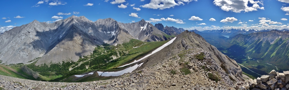
A final 360-degree panorama from the beautiful summit of Opal South. Click and drag to explore the area’s peaks or look straight down the peak’s sheer west face!
.jpg)
After a brief summit stay, we remembered that we had kids to get home to and started, what we hoped would be, a rapid descent (spoiler alert: it was not!).
.jpg)
Beautifully up-tilted rock strata are a hallmark of the Opal Range and can readily be seen on both micro- and macro-scales.
.jpg)
Brianne cautiously descends steep slopes. After our ascent took only 2 hours, we’d hoped to be down Opal South in about 1 hour. Unfortunately, the peak’s combination of a thin layer of scree atop rock-hard dirt made for a tedious descent. When coupled with the myriad of ‘sucker trails’ which lead to more moderate scrambling, our hike down ended up taking nearly as long as our hike up had!
.jpg)
The descent took longer than we’d hoped but sometimes you just have to stop to smell the flowers (in this case a wild rose) … and sometimes you also need to stop to grab a beer and some nachos before heading home to relieve your tired grandparent babysitters!
Cheers to a great date day with my beautiful ‘Breezy Goat!’
.jpg)
.jpg)
.jpg)
.jpg)