When I was younger, drinks, merriment and a late night were standard New Year’s fare. Obviously, my previous New Year’s celebrations killed too many brain cells because, these days, I’d prefer to celebrate with an alpine start and frozen extremities atop a snowy summit. When I really stop to think about it, I’m not sure which involves more suffering: a January 1 hangover or snowshoeing? I do, however, know which leaves me feeling better about myself! And so, as 2017 drew to a bitterly cold end, I made plans to start off 2018 in my favorite place: On Top!
Having discussed a holiday outing with Matt Clay when we last scrambled a few months ago, I was pleased to hear that he was still interested in joining despite, what promised to be, a chilly start. I was even more pleased to finally meet Matt’s lovely wife (and trail-breaking associate) Sandra. Together with Crux, we set out from Calgary at 6 am, braving treacherous icy and snow-blown roads. As we drove west, the temperature rose from -29 C to -16 C causing much excitement. By the time we reached our trailhead (the Sunshine Village parking lot), however, the temperature had dropped back to an unpleasant twenty below. Such is life in a climate where the local zoo has to move penguins inside due to extreme cold, I suppose. With the knowledge that a warmer mass of Pacific air was arriving at higher elevations, however, we wasted little time and started up the Healy Pass trail towards the Monarch Ramparts hoping to find warmer conditions (and great views) at elevation.
.jpg)
As we ascended the Healy Pass trail, the day’s first rays warmed the surrounding summits. Unfortunately, their effects would not be felt in the valley bottoms for hours…
.jpg)
Matt C. and Sandra snowshoe along the dull, densely forested Healy Pass trail. While Healy Pass is a spectacular place, the hike leading up to it is rather mundane. Having recently endured this trail on another trip, I opted to attempt it on skinny cross-country skis in the hopes of, at least, getting it over with quickly at the end of the day. As it turned out, the skis were only a minor advantage as many sections of the trail were too narrow to allow for the stylish descent I’d hoped for. Touring skis would be better here but their added weight would be a disadvantage on the trail’s many flat sections. Basically, the Healy Pass trail sucks regardless of your conveyance! For anyone else thinking about using skinny skis on this trail, I’d recommend using them until the E5 (Healy Creek) backcountry campground. Above this point, they were more trouble than they were worth!
.jpg)
After an hour, we found the bridge over Healy Creek impassable thanks to recent snowfall. Luckily the damned creek was frozen stiff so we just skied/snowshoed across it. While we’d assumed that the temperature would rise as we climbed, it initially did quite the opposite – bottoming out below -30 C here.
.jpg)
Sandra manages a smile despite the extreme cold. The Healy Pass trail is as mundane as they come, however, so at least her fogging glasses and goggles didn’t cause her to miss anything.
.jpg)
After 7 km and 2 hours in the icy shade, we finally felt the sun’s warmth upon reaching a small clearing. This clearing granted us our first views (click to see larger) of the Monarch Ramparts (right) extending northward from their much larger namesake mountain (center). Taking a break, Matt C. and Sandra refueled while I switched from my ski gear into my mountaineering boots/snowshoes. Although Matt C. and Sandra had been discussing the cold for some time now, I hadn’t really noticed it until we stopped. As soon as we did, however, I froze instantly.
.jpg)
Beyond the small clearing, the dense forest we’d grown accustomed to quickly gave way to open alpine meadows. We passed the turnoff for Eohippus Lake and continued north towards Healy Pass for a short distance (about 150 m) before noticing a broken trail heading in the direction of the Monarch Ramparts; could it be?!
.jpg)
Fortuitously, the broken trail deposited us exactly where we hoped it would: a low angled ramp on the south shore of the tarn closest to Healy Pass. This feature is the safest way to ascend the Monarch Ramparts in winter conditions (click to see our route); other possibilities (including a direct ascent from Healy Pass) involve steeper, potentially avalanche-prone slopes.
.jpg)
All good things must come to an end…while we’d been happy to follow broken trail 1 km further than anticipated, the ‘shoe track we’d stumbled upon petered out at the base of the Ramparts leaving us (read: Matt C and Sandra) to break trail the rest of the way (thanks again guys!).
.jpg)
While the ascent up the Ramparts was tiring, the ever-improving views towards Mount Assiniboine provided a convenient excuse to take frequent photo breaks!
.jpg)
Matt C. and Sandra explore an alpine basin at the top of the low-angled ramp. From here, the Ramparts’ high point is several bumps to the south (left), however, the safest way to get there involves sticking to lower-angled terrain on the right before turning back to the left atop the ridge.
.jpg)
Return of the post-holing puppy! Crux chugs along amidst awesome winter scenery as we near the ridgetop.
.jpg)
The winter sun sits low in the sky, casting long shadows and a golden glow across the spectacular alpine landscape east of the Monarch Ramparts. Click to see larger.
.jpg)
A closer look at the nascent cornices forming along the Ramparts’ ridge crest.
.jpg)
While the January sun is ideal for lighting, it (unfortunately) does little to provide warmth! As we reached the Ramparts’ ridge crest, we were greeted by -15 C temperatures and a stiff breeze from the west (better than -30 C, I suppose!). In addition to maintaining Crux’s frosty appearance, this also served to freeze my toes (despite the fact that I was already wearing toe warmers, insulated socks and mountaineering boots). This is the first time in my life that I’ve lost feeling in my feet while wearing toe warmers and I was forced to take a break until circulation could be returned to my wooden feet. While I rubbed my feet and added more heat packs, Matt C. and Sandra continued ahead lest they stop moving and start to freeze up as well!
.jpg)
By the time that feeling had returned to my feet, Matt C. and Sandra (just visible in the center of this photo) were nearing the Ramparts’ summit (a broad high point about a km south of where we’d first gained the ridge crest).
.jpg)
Fortunately, the ridge was generally windswept or covered in supportive wind-affected snow and where lee areas collected sugary powder, Matt C. and Sandra had already broken trail. As a result, Crux and I made good time as we hiked along the frozen ridge (photo courtesy Matt Clay).
.jpg)
Crux races to beat me to the summit as we rejoin Matt C. and Sandra atop the Monarch Ramparts (photo courtesy Matt Clay).
.jpg)
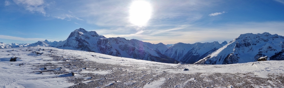
A spectacular panorama to the west from the Ramparts’ broad, windswept summit. This beats a New Year’s hangover anyday!!! Click to see larger.
.jpg)
“The Matterhorn of the Rockies” (Mount Assiniboine) and the Marshall (right) rise up beyond Simpson Ridge to the south while a distant Mount Sir Douglas is also visible on the far left.
.jpg)
Sandra and Matt C. pose beneath the Monarch.
.jpg)
To no one’s surprise the Monarch Ramparts provide perfect views of their spectacular namesake mountain.
.jpg)
The summit panorama to the west stretches from Kootenay’s East Verdant Creek (left) to Banff’s Egypt Lakes and is spectacular regardless of which jurisdiction it falls under. Click to see larger.
.jpg)
A closer look at Kootenay’s East Verdant Creek and Verdant Creek Valleys immediately west of the Monarch Ramparts. For much of the previous summer (2017), these valleys were ravaged by the massive Verdant Wildfire which burnt 176 square km (44,000 acres).
The Monarch Ramparts played a key role in the Verdant fire, acting as a physical barrier to keep the flames from reaching Banff/Alberta. Ever since the fire had been deemed “held”, I was curious to make my way to its edge to see how it had changed the mountain landscape.
As you can see from the photo, the entire valley between the Ramparts and Mount Schanks (left) and Hawk Ridge (right) was razed. For a time, Schanks and Hawk kept the fire from encroaching on the Vermilion River Valley and Highway 93S further to the west, however, it eventually spread via the Simpson River to the south of Schanks.
.jpg)
Distant Mount White Tail is a stunning (unofficially named) high point along the Vermilion Range.
.jpg)
A glance north towards Egypt Lakes reveals how high the fire crept upon the west face of the Monarch Ramparts (note the singed trees on the ridge in the foreground). Across the East Verdant Valley, the Park Ranges (including from left to right: unnamed, Scarab Peak, the Sphynx, Mount Ball and Pharaoh Peaks) provide an aesthetic background to the blackened forest.
.jpg)
A closer look at the Verdant Fire’s northernmost reach along the Monarch Rampart’s west ridge.
.jpg)
Scarab Peak.
.jpg)
Crux and I celebrate the New Year in style atop a spectacular summit!
.jpg)
Group summit photo (minus Crux who decided he’d rather lay down in the shelter of a lee area).
.jpg)
Matt C. and Sandra (left) are dwarfed by the panorama to the north (click to see larger) as they begin to head back down. Having arrived on the summit before me, they were starting to freeze and, so, needed to start moving once more.
.jpg)
Gibbon Pass separates Storm Mountain (left) from Gibbon Pass Peak/Little Copper (right) beyond the northern edge of the Ramparts. Through the pass, distant Bow Peak and Observation Peak are visible while distant Mount Hector is obvious to the right of Gibbon Pass Peak.
.jpg)
Looking north, a broken trail leads up Healy Pass with Healy Pass Peak (center right) and Pilot Mountain (right) towering above. In the exact center of the photo, our low-angled ascent ramp (and ‘shoe track) is apparent in a shaded area near a frozen tarn.
.jpg)
Distant Skoki peaks visible beyond Healy Pass (from left to right: Mount Richardson, Pika Peak, Redoubt Mountain, Ptarmigan Peak, Armor Peak and Protection Mountain).
.jpg)
Looking out over the Sunshine Meadows to the east (click to see larger).
.jpg)
Mount Bourgeau rises up above the shade of our long approach valley (Healy Creek). Beyond Bourgeau, the Fairholme Range provides a scenic backdrop to the Bow Valley. The extensive forests in the foreground of this photo are about 1 km from where to Verdant Fire stopped. Had the fire managed to cross the Ramparts, this forest would have provided a direct path towards Banff!
.jpg)
Looking east towards the Sunshine Village ski resort (from left to right: Eagle Mountain, Mount Howard Douglas, Lookout Mountain and Brewster Rock). While throngs of people flocked to Sunshine to ring in the New Year, we didn’t see another soul apart from our brief time in the trailhead parking lot. As bad as skiing up Healy Creek in -30 C seemed, sitting idle on a windy chairlift sounds much worse!
.jpg)
Eagle Mountain (aka: Goat’s Eye Mountain as Sunshine arbitrarily named it) beyond Wawa Ridge.
.jpg)
Mount Howards Douglas, Lookout Mountain and Brewster Rock (the highpoint of the Sunshine ski resort). A short time after this photo was taken, we heard several large avalanches which caught us off guard given how stable the snowpack was; perhaps the ski area was performing avalanche control in Delirium Dive?
.jpg)
The Sunshine Meadows stretch south towards Mount Assiniboine (click to see larger).
.jpg)
Pointy Nasswald Peak (left) highlights the view over the Simpson River Valley to the southeast. The Verdant Fire also worked its way up this valley. Fortunately, it did not reach Simpson Pass or, once again, it would have had a clear path towards Banff.
.jpg)
Crux looks stoic atop the Monarch Ramparts while a fighter jet flies over us. Every year I attend multiple sporting events that feature fighter jet flyovers. These never fail to scare the $hit out of me in a stadium when I’m expecting them (say nothing of atop a quiet mountain when I’m not)!
.jpg)
After collecting a myriad of summit photos in every direction, I reluctantly put away my camera and Crux and I started back down along the ridge, catching up to Matt C. and Sandra a short time later.
.jpg)
Late afternoon shadows overtake Matt C. and Sandra as they plunge step back down the steepest section of our ascent ramp.
.jpg)
Looking back up towards the Monarch and the Monarch Ramparts (right) as the sun dips behind the continental divide.
From this point on, Matt C. and Sandra started their snowshoe down the dull Healy Creek trail while Crux and I took a break. After enjoying a hot cup of tea amidst the icy peaks, I took off my snowshoes and put my frozen ski boots and skinny skis back on.
Setting off downhill, I thought I’d catch Matt C. and Sandra in no time. What I hadn’t banked on was how difficult the narrow Healy Pass Trail would be to navigate on skinny skis! Much of the trail is steep enough to get some good speed going, however, it is far too narrow to control that speed with a snowplow! Being in the woods, there are plenty of obstacles to avoid as well!
I’m a good cross-country skier and a very able downhill skier. I’ve been on skis since I was 3 years old and am quite comfortable in expert (black, double black etc.) terrain. In the past decade, I’ve probably fallen on skis twice. I went a$$ over tea kettle at least 6 times while attempting to ski down Healy Creek (although I blame Crux for cutting me off on at least 1 of those spills). After finding myself face down in the snow a number of times before reaching the E5 backcountry campground, I finally started to make better time as the terrain eased below. I finally caught up to Matt C. and Sandra 3 km above the Sunshine parking lot. Having expected to be passed 3 or 4 km earlier, they were relieved to see that I’d survived my descent and moved aside for me to pass (I was in full-on GTFD mode by then).
The last 3 km down to the parking lot went quickly on skis and Crux and I were happy to relax in our warm car for 20 minutes before Matt C. and Sandra caught back up to us.
Was it cold? F*ck yes. Do I ache from head to toe? Most certainly. Do I miss staying up late to ring in the new year with a selection of fine ales and good friends? Sometimes…but in the end, there’s no better way to start the year off than On Top! Happy New Year!
.jpg)
.jpg)
.jpg)
.jpg)
.jpg)
.jpg)
.jpg)
.jpg)