Elevation: 1875 m (Pass) 1935 m (Hill)
Elevation Gain: 425 m (Pass) 485 m (Hill)
Grass Pass is popular hike accessed via the well-travelled Pack Trail Coulee. The pass is open and grassy (likely the origin of its name), granting pleasant views of South Kananaskis. Although the name has been in use since the 1930s, it was not granted official status until 1980.
My Ascents:
May 6 2018
Trailhead: Sentinel Day Use Area
Growing up, I was dragged up Grass Pass by my parents at least once per year. Although I have fond memories of these trips, my recent preference has been to explore new areas, forsaking the familiar for the exciting. Now that I have a family of my own, however, the comfort of familiar is becoming more welcome. Researching a new hike for myself involves a good deal of work. Researching one that will be suitable for my toddler, baby and forgotten child (the dog) is an even more significant undertaking. As a new parent, I really don't have the energy to justify all that effort! When presented with a warm, sunny May Sunday, I therefore decided that it was time to introduce a new generation to Grass Pass!
The family starts up the road-like trail. Shortly after this photo was taken, we made an unsettling discovery: a freshly severed deer leg in the middle of the trail. With a flick of my hiking pole, I quickly launched the limb into the woods (hopefully sparing my daughters some trauma). After some discussion, Brianne and I elected to continue hiking but raised our ‘bear alert’ level. This precaution would seem to have been merited given our later discovery that a bear attacked a dog nearby the day prior!
Teaching the next generation how to hike safely in bear country!
As the trail leaves the woods behind, our destination for the day comes into view. Grass Pass is the low point on the left, however, the grassy hill to the right requires only slightly more effort to ascend and offers much better views. Despite the unusually high snowpack this year, we were pleased to discover that our route was almost entirely snow-free (sometimes it pays to pick a hike which ascends open, south-facing slopes).
Penny enjoys the cool mountain breeze on an otherwise warm Sunday afternoon.
Brianne and I with our ‘training weights’ at the pass. The views from the pass are pleasant but we all know that higher is better…
Penny enjoys a lift up the small grassy hill east of Grass Pass.
Brianne tackles the final, gentle slopes to the high point immediately east of the pass. This hill is only 60 m higher than the pass but offers significantly better views west towards the area’s more impressive peaks. In short, it’s well worth the small added effort. Ambitious parties can continue to wander east from the highpoint to explore the Bull Creek Hills, however, that outing is likely to be less toddler-friendly than the pleasant hike up Grass Pass Hill.
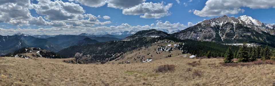
Forested foothills fill the panorama to the south from the hill’s high point. To the left, these hills dwindle as they encroach upon the expansive prairies while they rise up to the right, eventually culminating in the large peaks of the continental divide. Click to see larger.
Looking beyond the south ridge of Bull Creek Hills towards the prairies. With the snow in this area having only recently disappeared, we were surprised to spot a nearby wildfire (mouse over for a better look).
Mera, Crux and I enjoy the views southward from our little grassy ‘summit’.
A still snowy Raspberry Ridge rises up beyond Hell’s Ridge (sounds pleasant, no?) and Mount Mann. Beyond, the snowier-still High Rock Range (Mounts O’Rourke and Farquhar specifically) divides Alberta from British Columbia.
The spectacular panorama to the west which justifies coming back year after year. Click to see larger.
Our ‘forgotten child’ happy to be hiking again.
High Rock Range views to the southwest. From left to right: Mount O’Rourke, Mount Farquhar, Mount Etherington and Baril Peak.
Mount Armstrong makes an appearance beyond the Gunnery-Holy Cross col to the west.
To the west, Holy Cross Mountain (center) and Mount Head (right) tower above Grass Pass (left).
Crux patiently waits for Mera to accidentally drop her sandwich…
A closer look at nearby Holy Cross Mountain. Unfortunately, the peak’s characteristic cross is still buried under this year’s heavy front range snowpack.
Mount Head to the northwest.
The northern edge of the nearby Highwood Range includes pointy Pyriform Mountain (center left) and Junction Mountain (right).
My perfectly posed girls enjoy the spring sunshine atop Grass Pass Hill. If only they posed like this on their own (mouse over to see who was really responsible for this cute pic)…
The girls take in the last of the views before starting back down.
Brianne ambles down one of the dozen tracks which cut their way down the hillside from Grass Pass (an obvious indication of the area’s popularity).
Naptime snuck up on someone. Looks like I lost my bear-calling assistant (Yo Bear)!
Mera’s lost baby recovered near the severed deer leg at the trailhead. Fortunately, ‘Baby’ seems to have fared better on her own than ‘Bambi’ did…
My little hiker enjoys a well-earned treat (40 minutes after ordering it!) at the Hitchin’ Post in High River. Now that she’s learned to associate hiking with ice cream, I’m sure that we’ll all be hiking back up Grass Pass again soon!
.jpg)
.jpg)
.jpg)
.jpg)
.jpg)
.jpg)
.jpg)
.jpg)
.jpg)
.jpg)
.jpg)
.jpg)
.jpg)
.jpg)
.jpg)
.jpg)
.jpg)
.jpg)
.jpg)
.jpg)
.jpg)
.jpg)
.jpg)
.jpg)
.jpg)
.jpg)
.jpg)